Tennessee Valley Photos


You might also consider
More like Tennessee Valley
Recommended Reviews - Tennessee Valley
Start your review...

Reviews With Photos

Beautiful and heavily trafficked hiking area in Mill Valley. We did the Tennessee Valley trail down to the beach and then the Lower Tennessee Valley trail on our way back. The two routes were the same, aside from a short stretch of trail. The lower trail is a bit more narrow, but doesn't have as much elevation gain as the namesake trail, which still didn't have anything too aggressive. There were plenty of paths and trails that you could take in the area, some easier and flatter (the two mentioned above) and others on the steeper side. Once down to the beach the area is fairly small and there isn't too much to explore, but the rock walls surrounding the beach are pretty cool. There's also a set of stairs right before the beach that you can climb up to get to what I assume is a good view. It was foggy when we were there so we didn't make the climb. The area doesn't have much shade so be prepared to lots of direct sunlight, especially on those warmer days. There is a parking lot as well as street parking in the dirt that lines the road. The lot and sides of the road were absolutely packed when we came on a Saturday, but since it is heavily trafficked people are constantly leaving so snagging a spot wasn't too hard.

Basic hike takes about 3.84 miles out and back on an easy road with not too much elevation out to a beach. The beach is calm and nice for photos. There are no bathrooms here so it's best to go on the trailhead beforehand. There are a bunch of other trails if you don't do the main one, you can get to the Marin Headlands, you can get the Muir Beach, all depending on how long you wanted to go. The parking lot gets PACKED on the weekends, and you may have to park down the street and walk in far. Weekdays aren't as bad.

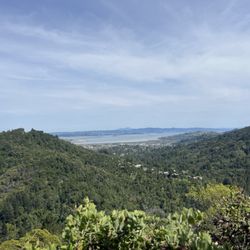
Free Parking in Lot & Road. Arrive Early (Before 8AM on Weekends) for Parking. Bathroom at Trail Start. Varying Length Trails. Mountain & Water Views. Popular Among Bikers, Hikers, & Runners. Trails are Biosterous. See Below for More Information: Free Parking in Lot & Road; There is free parking in the lot at the start of the trail. Additionally, cars park alongside the road on both sides leading up to the trail. Arrive Early (Before 8AM on Weekends) for Parking: Most of the parking spots in the lot are taken by 7AM on weekends. People then start to park along the road. Upon finishing my hike around 8AM, many cars were turning back as there were no more spots. Hence, I recommend arriving early to secure yourself a parking spot. :) Bathroom at Trail Start: There are two gender neutral restrooms located at the start of the trail. However, these are solely stalls without a sink. I suggest having some hand sanitizer at hand. Varying Length Trails: Depending on your energy and fitness levels, you and/or your party can make your hike as short or long as you would like. The shorter trail is at about one mile and longer version at about seven miles. Most of the trails are well-kept. The terrain varies from dirt to stairs and grass. Mountain & Water Views: Tennessee Valley is a beautiful hiking destination offering both mountain and water views. The mountain scenery is visible at the start of the trails while to get to the water, it is about a three-mile hike roundtrip. Popular Among Bikers, Hikers, & Runners: Given the beauty, Tennessee Valley is popular among bikers, hikers, and runners. If you are hiking, expect to be stopping constantly for runners and bikers, especially if you are doing a longer hike. Trails are Biosterous: Tennessee Valley is among the most boisterous trails I have hiked thus far. People are loud and conversations project.

Gotta give a shout out to my oldest to keep us moving forward.. I remember the days of taking trips to Santa Rosa, Petaluma and Mill Valley.. So nice to see such nice scenery... Made it to the beach area.. So serene and calm being near the beach.. Hearing the waves.. So grateful for every day! Life is getting better...

We arrived around 10:30am on a Sunday morning and it was already getting busy. Driving up, there were still lots of open spots on the side of the road but that required a bit of a walk to the actual trailhead. We tried the main parking lot and was lucky enough to find a spot! Parking is free so I would attempt the main lot first. It was a very sunny day but the winds were cold. Definitely bring a jacket for the start of the hike if you are going in the morning. It was a very easy hike with clear signs marked throughout the trail. Once you reach Tennessee Beach, there's are stairs that leads up to the Tennessee Beach Outlook for a much better view. Up there, you will also see an old bunker. The hand washing area at the parking lot ran out of water so I suggest bringing some extra water bottles or sanitizing wipes just in case. There are some picnic benches in the parking lot as well if you want to have a picnic.

"Take the Lower Trail 3x" My first time at this preserve, and I concentrated on the main Tennessee Valley Trail. The round trip is only 3.6 miles, so I ran it three times. You're not required to obey me, but you should. The day I visited, 3 emergency vehicles were called to rescue someone who was too tired to hike out. (No, that person was not really me.) Whilst the rescuers were searching down by the beach, the person walked out. When the 4th emergency vehicle started going down the road, I stopped it and explained the person was no longer there. They were grateful, and all was well. The main trail is great for hiking, biking or running, as it is not very steep. It takes you all the way to Tennessee Beach, which is a nice spot. You can run in the sand and play in the water, or just enjoy the nice view. There's a a little look-out up above to get an even better view. The trailhead has a huge amount of free parking spaces, but even on a weekday, most of them were filled up. On a weekend in summer this place must be a madhouse. At the beach, there are big signs warning you that you will die if the dam breaks. What dam are they talking about? And is it likely to break? Yes, these are indeed questions that must be pondered. About halfway down the trail, you have an option to stay on the main trail or take the lower trail. The lower trail is less hilly and more beautiful, so I recommend that option. The trails here are well-maintained and there are even several outhouses around the trails. There's a large information booth at the trailhead, but no maps. Please add maps. Don't be cheap. So overall a good visit. Yes, it's fun to see the ocean, but aside from that it's nothing special. For a better trail run I recommend Windy Hill in San Mateo.

Recently visited the Tennessee Valley Hiking Trail and can't wait to return! This trail is mostly level, some incline but just enough to get that heart rate going - the hike to the beach is about 1.8 miles (it took us about 45 min to walk there, at a gentle pace). And just as everyone else mentions, for those more adventurous, there are a number of additional trails leading off to the trails that split off from the main trail. However, I must say, the best part is ending your walk/bike ride at the beach. Things to note: - free parking, fills up quickly but no worry as cars start parking on the edge of the road near the entrance - bathrooms are available - there are picnic tables available - trail starts paved but turns into an unpaved trail - I saw many people on bikes - the beach is mostly sand and tiny rocks - don't forget your water!

Great hike await you at Tennessee Valley. Sure you can take the path to the beach...and that is a wonderful little walk. But there is so much more under the surface. There are trails leading to Zen Green Gulch, Muir beach, Rodeo Beach. The permutations are endless. Great exercise and training for backpacking, hiking, trips. Nice parking lot that is getting upgraded. Highly recommend

Visited Marin county and we wanted an easy hike, so the Tennessee Valley Trail was chosen. This is an easy 3.4mi trail and ends with a stunning view of the beach. There is a free parking lot area that's s but bumpy because it is a dirt road. I recommend getting here early to grab a good parking spot, it's a popular hike. There are minimal elevation changes, so it's an easy stroll for the most part. The view of the beach is stunning and we spent a good 20 mins admiring it. There isn't much shade, so I can see it being quite hot during the summer. We visited in November, so it was a chilly and windy, but definitely got a bit warmer as we hiked.
Really nice trail. Paved for a bit but established enough trail for all ages. I saw people of all ages make it to the beach. If you're feeling like you need more, there are several more challenging trails that splinter off and a beautiful lookout the is worth the short climb up. It's unfortunate that some very rude people were picking flowers even though there are signs posted everywhere to respect that botanical life. There are bathrooms at the beginning and end of the trail. Lovely day out

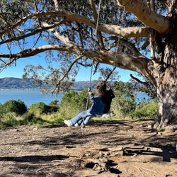
This has been my sanity saver during this time of Covid. All my time living in the area this has been my re-charge place. It's a good relatively easy walk out to the ocean and back. Cell reception is thankfully terrible ! The world can wait. The scenery and views are beautiful. I have seen plenty of wildlife from rabbits to stags. Once on the beach there are cliffs making a break from the wind and a good sized sandy beach. There is an old fort one can hike up to. The views are stunning from there. There are plenty of more moderate and harder trails off the main trail. One can hike up far enough to see Stinson beach and or the Golden Gate Bridge. Plenty of people run, hike, and walk this trail. Be mindful to keep social distancing yourself. It's generally very doable. I look forward to seeing this place again!

I love this hike so very much. Kevin and I went on a Tuesday during Covid times and let me tell you the weekend after Christmas was crazy we had to park pretty good distance away from the main parking lot so we had to walk all the way up the hill. But we didn't mind that at all actually worked out pretty well because after our hike it got really crowded and it was hard for cars to back up. The Tennessee Valley Trail leads up to a beautiful scenic pebble beach In between big rocks surrounded with mountains and unfortunately lots of poison ivy. I repeat POISON IVY!!! Once you get to a more muddy area of the trail you have to keep an eye out for these poison ivys. There are two trail tracks you are given either the lower side of the Tennessee Valley Trail or the upper side which is pretty self-explanatory, on our way there we took the upper part of the valley trail hike which had a couple Steep grounds and loose gravel but it wasn't too bad! On our way back we went to a more straight tomorrow flat lower side of the hiking trail which was also pretty cool cool. I suggest coming in really really early to get a really good parking or come in maybe later on the afternoon when people are starting to leave. Overall this hike was great it had great Inclines and three views of the mountains as well as rocks. Definitely coming back

Plenty of parking in the lot and overflow on the side of the street. We took the Tennessee Trail that ends at the beach and takes about 1.7miles one way. The first half is paved, but the overall trail was mild-moderate with minimal elevation changes. Scenery is pretty nice with views of valleys, mountains and the ocean along the trail. There's plenty of connecting trails that you can explore and I will definitely be back to check them out. Recommend wearing layers as it can get a bit windy.

Great family friendly hike (the main Tennessee Valley trail) with a nice beach at the turnaround point. You have the option to take a flatter lower route or get more views and exercise by going up some mild hills on the route. Our 6 year old made the 4 mile trek no problem. An off road stroller could be easily used or you can carry a toddler in a pack (heavy but no dangerous moments). read more


You might get a foggy gray day, you might get a sunny day. Better vivid colors on a sunny day but you can't plan that. You get what you get and enjoy it anyway Many trails, though I thought it was slightly confusing. Make sure to take a pic of the map at the trailhead to keep with you. Keep you on track as you come to a few forks Going up the hill on Fox trail was pretty good exercise and a nice challenge. Take it easy and slow. The beach was nice surprise, pebble beach and then becomes sand when you get closer to the ocean. Can only get here by hike. Careful of rip tides and as tempting as it is, don't go too close to the water! Watch your kids I saw deer, rabbits, birds, lots of dead fish scattered along the trails (dropped by birds from the sky) Parking is tough, get here by 9am weekend for one of the last spots. Around 1pm people are done and leaving read more


1 year ago
Beautiful and heavily trafficked hiking area in Mill Valley. We did the Tennessee Valley trail down to the beach and then the Lower Tennessee Valley trail on our way back. The two routes were the same, aside from a short stretch of trail. The lower trail is a bit more narrow, but doesn't have as much elevation gain as the namesake trail, which still didn't have anything too aggressive. There were plenty of paths and trails that you could take in the area, some easier and flatter (the two mentioned above) and others on the steeper side. Once down to the beach the area is fairly small and there isn't too much to explore, but the rock walls surrounding the beach are pretty cool. There's also a set of stairs right before the beach that you can climb up to get to what I assume is a good view. It was foggy when we were there so we didn't make the climb. The area doesn't have much shade so be prepared to lots of direct sunlight, especially on those warmer days. There is a parking lot as well as street parking in the dirt that lines the road. The lot and sides of the road were absolutely packed when we came on a Saturday, but since it is heavily trafficked people are constantly leaving so snagging a spot wasn't too hard. read more


Basic hike takes about 3.84 miles out and back on an easy road with not too much elevation out to a beach. The beach is calm and nice for photos. There are no bathrooms here so it's best to go on the trailhead beforehand. There are a bunch of other trails if you don't do the main one, you can get to the Marin Headlands, you can get the Muir Beach, all depending on how long you wanted to go. The parking lot gets PACKED on the weekends, and you may have to park down the street and walk in far. Weekdays aren't as bad. read more


Free Parking in Lot & Road. Arrive Early (Before 8AM on Weekends) for Parking. Bathroom at Trail Start. Varying Length Trails. Mountain & Water Views. Popular Among Bikers, Hikers, & Runners. Trails are Biosterous. See Below for More Information: Free Parking in Lot & Road; There is free parking in the lot at the start of the trail. Additionally, cars park alongside the road on both sides leading up to the trail. Arrive Early (Before 8AM on Weekends) for Parking: Most of the parking spots in the lot are taken by 7AM on weekends. People then start to park along the road. Upon finishing my hike around 8AM, many cars were turning back as there were no more spots. Hence, I recommend arriving early to secure yourself a parking spot. :) Bathroom at Trail Start: There are two gender neutral restrooms located at the start of the trail. However, these are solely stalls without a sink. I suggest having some hand sanitizer at hand. Varying Length Trails: Depending on your energy and fitness levels, you and/or your party can make your hike as short or long as you would like. The shorter trail is at about one mile and longer version at about seven miles. Most of the trails are well-kept. The terrain varies from dirt to stairs and grass. Mountain & Water Views: Tennessee Valley is a beautiful hiking destination offering both mountain and water views. The mountain scenery is visible at the start of the trails while to get to the water, it is about a three-mile hike roundtrip. Popular Among Bikers, Hikers, & Runners: Given the beauty, Tennessee Valley is popular among bikers, hikers, and runners. If you are hiking, expect to be stopping constantly for runners and bikers, especially if you are doing a longer hike. Trails are Biosterous: Tennessee Valley is among the most boisterous trails I have hiked thus far. People are loud and conversations project. read more

Gotta give a shout out to my oldest to keep us moving forward.. I remember the days of taking trips to Santa Rosa, Petaluma and Mill Valley.. So nice to see such nice scenery... Made it to the beach area.. So serene and calm being near the beach.. Hearing the waves.. So grateful for every day! Life is getting better... read more


4 years ago
We arrived around 10:30am on a Sunday morning and it was already getting busy. Driving up, there were still lots of open spots on the side of the road but that required a bit of a walk to the actual trailhead. We tried the main parking lot and was lucky enough to find a spot! Parking is free so I would attempt the main lot first. It was a very sunny day but the winds were cold. Definitely bring a jacket for the start of the hike if you are going in the morning. It was a very easy hike with clear signs marked throughout the trail. Once you reach Tennessee Beach, there's are stairs that leads up to the Tennessee Beach Outlook for a much better view. Up there, you will also see an old bunker. The hand washing area at the parking lot ran out of water so I suggest bringing some extra water bottles or sanitizing wipes just in case. There are some picnic benches in the parking lot as well if you want to have a picnic. read more


"Take the Lower Trail 3x" My first time at this preserve, and I concentrated on the main Tennessee Valley Trail. The round trip is only 3.6 miles, so I ran it three times. You're not required to obey me, but you should. The day I visited, 3 emergency vehicles were called to rescue someone who was too tired to hike out. (No, that person was not really me.) Whilst the rescuers were searching down by the beach, the person walked out. When the 4th emergency vehicle started going down the road, I stopped it and explained the person was no longer there. They were grateful, and all was well. The main trail is great for hiking, biking or running, as it is not very steep. It takes you all the way to Tennessee Beach, which is a nice spot. You can run in the sand and play in the water, or just enjoy the nice view. There's a a little look-out up above to get an even better view. The trailhead has a huge amount of free parking spaces, but even on a weekday, most of them were filled up. On a weekend in summer this place must be a madhouse. At the beach, there are big signs warning you that you will die if the dam breaks. What dam are they talking about? And is it likely to break? Yes, these are indeed questions that must be pondered. About halfway down the trail, you have an option to stay on the main trail or take the lower trail. The lower trail is less hilly and more beautiful, so I recommend that option. The trails here are well-maintained and there are even several outhouses around the trails. There's a large information booth at the trailhead, but no maps. Please add maps. Don't be cheap. So overall a good visit. Yes, it's fun to see the ocean, but aside from that it's nothing special. For a better trail run I recommend Windy Hill in San Mateo. read more


4 years ago
Recently visited the Tennessee Valley Hiking Trail and can't wait to return! This trail is mostly level, some incline but just enough to get that heart rate going - the hike to the beach is about 1.8 miles (it took us about 45 min to walk there, at a gentle pace). And just as everyone else mentions, for those more adventurous, there are a number of additional trails leading off to the trails that split off from the main trail. However, I must say, the best part is ending your walk/bike ride at the beach. Things to note: - free parking, fills up quickly but no worry as cars start parking on the edge of the road near the entrance - bathrooms are available - there are picnic tables available - trail starts paved but turns into an unpaved trail - I saw many people on bikes - the beach is mostly sand and tiny rocks - don't forget your water! read more

Great hike await you at Tennessee Valley. Sure you can take the path to the beach...and that is a wonderful little walk. But there is so much more under the surface. There are trails leading to Zen Green Gulch, Muir beach, Rodeo Beach. The permutations are endless. Great exercise and training for backpacking, hiking, trips. Nice parking lot that is getting upgraded. Highly recommend read more


5 years ago
Visited Marin county and we wanted an easy hike, so the Tennessee Valley Trail was chosen. This is an easy 3.4mi trail and ends with a stunning view of the beach. There is a free parking lot area that's s but bumpy because it is a dirt road. I recommend getting here early to grab a good parking spot, it's a popular hike. There are minimal elevation changes, so it's an easy stroll for the most part. The view of the beach is stunning and we spent a good 20 mins admiring it. There isn't much shade, so I can see it being quite hot during the summer. We visited in November, so it was a chilly and windy, but definitely got a bit warmer as we hiked. read more


2 years ago
Really nice trail. Paved for a bit but established enough trail for all ages. I saw people of all ages make it to the beach. If you're feeling like you need more, there are several more challenging trails that splinter off and a beautiful lookout the is worth the short climb up. It's unfortunate that some very rude people were picking flowers even though there are signs posted everywhere to respect that botanical life. There are bathrooms at the beginning and end of the trail. Lovely day out read more


This has been my sanity saver during this time of Covid. All my time living in the area this has been my re-charge place. It's a good relatively easy walk out to the ocean and back. Cell reception is thankfully terrible ! The world can wait. The scenery and views are beautiful. I have seen plenty of wildlife from rabbits to stags. Once on the beach there are cliffs making a break from the wind and a good sized sandy beach. There is an old fort one can hike up to. The views are stunning from there. There are plenty of more moderate and harder trails off the main trail. One can hike up far enough to see Stinson beach and or the Golden Gate Bridge. Plenty of people run, hike, and walk this trail. Be mindful to keep social distancing yourself. It's generally very doable. I look forward to seeing this place again! read more

I love this hike so very much. Kevin and I went on a Tuesday during Covid times and let me tell you the weekend after Christmas was crazy we had to park pretty good distance away from the main parking lot so we had to walk all the way up the hill. But we didn't mind that at all actually worked out pretty well because after our hike it got really crowded and it was hard for cars to back up. The Tennessee Valley Trail leads up to a beautiful scenic pebble beach In between big rocks surrounded with mountains and unfortunately lots of poison ivy. I repeat POISON IVY!!! Once you get to a more muddy area of the trail you have to keep an eye out for these poison ivys. There are two trail tracks you are given either the lower side of the Tennessee Valley Trail or the upper side which is pretty self-explanatory, on our way there we took the upper part of the valley trail hike which had a couple Steep grounds and loose gravel but it wasn't too bad! On our way back we went to a more straight tomorrow flat lower side of the hiking trail which was also pretty cool cool. I suggest coming in really really early to get a really good parking or come in maybe later on the afternoon when people are starting to leave. Overall this hike was great it had great Inclines and three views of the mountains as well as rocks. Definitely coming back read more


5 years ago
Plenty of parking in the lot and overflow on the side of the street. We took the Tennessee Trail that ends at the beach and takes about 1.7miles one way. The first half is paved, but the overall trail was mild-moderate with minimal elevation changes. Scenery is pretty nice with views of valleys, mountains and the ocean along the trail. There's plenty of connecting trails that you can explore and I will definitely be back to check them out. Recommend wearing layers as it can get a bit windy. read more


6 years ago
It felt like Spring was in the air today at Tennessee Valley. I lucked out on the gorgeous weather, but be prepared for possibly foggy and freezing conditions. Wear layers just in case. The Coastal trail is a 3 mile loop. There are technically two paths: one is completely flat while the other is mostly flat with a couple steep inclines. It is surrounded by lush green hills, amazing cliffs, wildflowers, and wildlife. There are several warning signs on the trail of coyotes. To the right of the Coastal trail is a big steep hill which is the Muir Beach trail. One of my goals is to hike that trail one day. Parking fills up quickly on the weekends. It is an unpaved lot with pot holes. When I finished my hike mid morning, there were about two miles of cars parked alongside the road. It is not dog friendly. read more


2 years ago
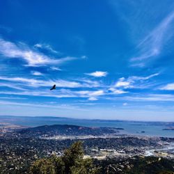
Tennessee valley, coastal, coyote ridge, and miwok loop. Here's my trail map. https://www.gaiagps.com/public/vgOC9WbWYGEOFD2DsjleD5lx This is easily one of the best hikes in the San Francisco Bay area. I made the mistake of going clockwise because I missed the counterclockwise starting point, but in the end the trail shocked and amazed. I recommend counterclockwise because the home stretch would be all flat from the beach to the parking area. if you go clockwise you'll hit the beach first. it's a beautiful beach with an amazing geologic showing of radiolarian chert. after the beach going clockwise you will veer off to the left and begin your ascent. the views are stunning in all directions from almost every inch of the trail. as you approach the high point look off to the north and you'll see the Golden gate bridge and the Salesforce Tower peaking through an opening in the mountain. even the steep parts are a perfect combination of climb and plateau. I arrived at 1300 on the most beautiful day and there was still plenty of parking. if your goal is a simple hike from the parking lot to the beach take the lower Tennessee valley trail out and back. read more


5 years ago
If you're in Mill Valley, I'd highly highly recommend trying this trail out close to sunset ! The trail is a 3.4 mile long out-and-back trail (1.7 mile either way) that opens up to a beautiful "black sand" beach that provides majestic views of the sunset. With regards to elevation, this trail can be considered as an easy one with fairly low elevation (170 ft.) .. if you're coming here alone, I'd recommend avoiding it after dusk due to high coyote activity. read more


Nice hike and fairly level but also fairly common to get your car broken into. Glass in the main lot from the car before us and ranger taking another report and a broken window as we were leaving And Christmas eve at that. Parker beware, I will not be back. read more

6 years ago
The trails of Tennessee Valley in Marin County might just be the most accessible and well-thought out network of trails in the Marin Headlands. There are so many rolling hills of lush greenery, mixed with burgeoning wildflowers, creeks and it all leads to one of the most spectacular beaches in the entire Bay Area. I had the opportunity to come with a group of friends on a cold but cloudy Sunday afternoon who were planning a picnic on Tennessee Beach. But first we had to get there and it's a short exit from Highway 101 off the Shoreline Highway exit. After a winding drive up, be wary that there is an smaller entrance alongside Tennesee Valley Road where you'll see a sign saying Tennessee Valley but that's not necessarily the main trail, the is the Oakwood Valley Trail which leads you all the way into the hills. You want to continue heading north to the Tennessee Valley Trailhead which is at the end of Tennessee Valley Road. There is parking but it fills up fast, even on a post rainy day we had to park all the way down the hill and walk up to the park area to meet the rest of our party. There are also a number of trails in Tennessee Valley, from Miwok to Marincello, they all seem to head in different directions, but the main trailhead leads you right to the beach with its beautiful views and cliffs, it can be a paradise when not too crowded or foggy. Getting to the beach is the easy part, a steady trek down the path and you're there right at a poorly diverted stream that makes for crossing rather unbearable but with a hop and a jump you're there. There are also some nice lookouts for those of you who need a better view of the ocean, but they require a bit of a hike through jagged cliff and man-made steps, but what a view it is when you get to the top! When hiking back to the parking lot you may better notice a fork in the road leading to what seems like another path headed toward a different direction and not back tot he parking lot, on my first trip we decided to stay on course and head back uphill on the asphalt road, since we knew where that was going and where we would wound up. It turns out both paths eventually rejoin together eventually, so my best advice is to stay to the right each time, whether your headed to the beach or back to your car, especially if you are not an experienced hiker because the trek uphill, although paved can be quite exhausting. Either way we had a great time, and I would totally go on that hike again with the perfect views and weather and a mild walk to boot, no wonder why the parking lot was so full that Sunday morning we visited. I'd try to get there early as well! read more


Such a breathtaking beauty! Memories of my last visit here are replaying in my head like a movie on repeat. A plethora of walking and hiking trails, the soothing waves of Tennessee Beach, and the most astounding views of the Tennessee Cove await you here at Tennessee Valley. I'll admit that I've been slacking when it comes to being physically active as of late. But, the short and relatively easy hike out to Tennessee Beach really inspired me to get back to my old hiking self. I had never even heard of Tennessee Valley until I was invited here as a plus one for a Yelp Elite Event. Tennessee Valley is located on the way to Muir Woods and Mount Tamalpais. It's tucked away on an off street just off of highway 1. On the drive here, you'll pass by a large sign with the Tennessee Valley namesake. You can most certainly park on the side of the road and begin your hike here, but the main entrance is about another mile down. You'll reach a dead end with a parking lot once you've reached this entrance. When I say that there are tons of trails, I'm not exaggerating! Right from the parking lot, you'll find several different trailhead entrances that will take you to different areas of Marin. Rodeo Beach, Pirate's Cove, and Muir Beach are just some of the few destinations that are accessible through the hiking trails here. We took the Tennessee Valley trail which took us directly to Tennessee Beach. The trail is roughly 4 miles roundtrip and is out and back. The path is a flat dirt trail with minimal inclines. I spotted a few other trails that looked to be a lot more challenging in the distance, so there are hiking trails available for all skill levels. Along the hike, I enjoyed the beautiful views of the rolling Marin hills and the statuesque trees that lined the trailhead near the entrance. But the most rewarding element of taking this trail is ending it with an immaculate view of the beach. It was too chilly this time of year to actually get in, but the views and sounds were enough to fully satisfy me. The up close and personal view of the California coastline is just stunning. The beautiful blue beach water and the calming waves made for a wonderful experience. We took the small trek up to the Tennessee Beach Overlook before heading back to our cars, and I'd have to say that this was probably the biggest highlight of my hike. The hike up to the Overlook will have you out of breath from it's steep vertical incline and wide stairs. But, I would totally recommend it for the spectacular views! It's only 800 feet to the top! Just take a few rest breaks on your climb up, and you'll be there before you know it. The views up there are amazing and made the entire hike worth while for me. I'm so excited to come back to Tennessee Valley in the future to discover more hiking trails. If you're looking for a diverse mix of hiking trails with stellar ocean views, I would highly recommend it read more


This was a gorgeous and easy hiking destination, a combination of both mountains and sea between you. Not a very arduous trail, the Tennessee Valley allows beginners to enjoy the beauty without having to crawl their way across and climb on rocky hills. The walkway paths were smooth and simples, with rarely any rocking climbing experience required. With going back and forth, I ended up with over 15,000 steps for such an easy trail. The parking may be an obstacle because everyone comes and goes too fast, you may take several minutes to find a parking spot. Although, horse feces' unpleasant smell came across my path but that contributed too little to ignore the natural beauty of mother's nature. The ocean was clean and enjoyable. The coolness of the salt water was refreshing, although some of my mates thought that was too cold for their weak endurance. In my part, I adore the temperature. The rocky sands, however, hurt my feet. I must admit that my soles are thin. Overall, you can bring beach towel, a speaker, and something to lay on. That gives you an easy breeze and perfect nature to sleep upon. read more


WEREN'T ABLE TO LOCK IN A RESERVATION AT MUIR WOODS ON TIME?! Do not fret, my friends! I honestly had no idea Muir Woods started mandating reservations until after I had crossed the Golden Gate and saw a sign that stated it. Literally, my thoughts after driving almost 1.5 hours up were, "Oh Shxt!" And so what did I do?! As soon as I exited, I tried to make that super last minute phone call to Muir (while still headed to Muir), hoping I could still lock in a reservation. After about 15 minutes talking to a robot on the phone, I had found out that, of course, all reservations were taken for the day...but I didn't stop there! I decided to just pull over to the nearest neighborhood along the way and desperately Yelped for the closest hiking place next to Muir. Luckily enough, I stumbled across Tennessee Valley, which was only about 2-3 miles away! F*** yeah! Once I re-navigated myself over to Tennessee Valley, I really had no idea there was such a hike within such a close proximity to Muir Woods! It was truly a hidden gem within Mill Valley. Parking, although we went during a long weekend, wasn't as packed as I had anticipated, probably because everyone and their grandmaa must've been at Muir. My S/O and I decided to go ahead with walking the Tennessee Valley trail. Apparently, there are multiple trails within this area that you could choose from, granted, they all branch off from the main trail. The main hiking trail starts off pretty mellow in an area with lots of trees, mini bridges, and shade. After you walk about 3 miles into it, it gradually gets steeper as you ascend up the hill about 1.5 miles. This uphill climb was a bit steep, so if you're still a beginner hiker, I highly suggest you take your time up the hill and make sure to take breaks when needed. On the top, you will begin to see a view of the Marin right in front of you, which I found absolutely gorgeous. Also at the top, you will notice the main train branching off into two separate trails from you to choose from. Unfortunately, we decided to end our hike there as we wanted to go back and drop by the Golden Gate before heading back home. This day was exceptionally special in that it was clear blue skies and no wind, a rare moment in the Marin! After we reached the view, my S/O decided to take a few photos and take a few breaths while enjoying the lovely view that was in front of us. Afterwards, we turned back around and headed back down the hill we had initially climbed to get there in the first place. I would love to come back to this hidden trail again in hopes to explore more trails they have to offer. It was great to know that the tough uphill climb ended with a beautiful view - something hikers usually look forward to! read more


6 years ago
Love, love, love!! Definitely one of my favorite places to escape from negative world. It's one of my peaceful spot. Just keep on walking all the way to the end to the beach and just watching and hearing the waves tides...RELAXING! :) lol Definitely a lot of cardio (hiking, walking, bike rides,etc) People do wear mask. Which I like. Especially the 6ft. I need to stop by when I have a chance and just go get my peace. :) read more


5 years ago
I've been wanting to come here for a long time. I found this place on Instagram. We came early on a Thursday morning. It looks like parking gets full. There are several walk ways to the beach. There is one way at the bottom where you can take a stroller. There are different path ways that are a little harder on the hills. It's about 1 1/2 miles one way. The bottom has a little shade. The views are really nice. At the end you get to a small beach. It is very beautiful and relaxing. There are two bathrooms a long the way. Definitely would recommend coming here. read more

4 years ago
It's a short 1.8 mile hike one way and 1.8 back, but the view at the end is amazing. This is the second time I've been there and I can't believe its been so long. I will make it a regular thing with the family. read more


There's free parking in the parking lot and it wasn't difficult to find a spot. The trail is spacious and is good for mountain biking or jogging as well. The trail itself is dirt and is pretty smooth. It's often grey/overcast here and it can get windy. The views are very open and picturesque. Part of the coastal trail is steep and mainly uphill. I really enjoy how lush and green the hills. It looks like a peaceful and heavenly scene from a movie. There are nice ocean views from this trail. Some people mentioned not having cell phone reception here but my T-mobile phone service was fine. I didn't get a chance to do the full loop or to gain access to the beach but there are trails that lead to it. The trails are well marked with signs. I'd definitely love to come back here again to explore more trails. It's great because it isn't as popular or overcrowded as other SF hiking spots. read more

8 years ago
Came here for our first time and just did the 1.8 mile Tennessee Beach trail. Super easy trail for all ages. There were a few signs on our way to the beach informing us that there was a whale that washed up. It was mostly bones but the smell was diffenitly still there. The beach was to crowed and the weather was perfect the day we went. No jacket needed! We will be going back to learn more trails. On the way to the trail there was a veggie stand. Try the pickled green beans !! read more


7 years ago
Great hike! I got there fairly early on a Friday morning. The parking lot is fairly small! People were parking along side the road by the time I got there. The hike was great 1.8 miles from the trailhead to the beach. The entire trail is a nicely maintained path that is wide enough to accommodate groups of walkers. I also passed several folks on bikes. There are two trails out to the ocean, I took the upper path out and returned on the lower path. The lower path is much narrower. Once out at the beach, the climb to the cliff was slightly more challenging. If you are unsteady on your feet I would skip it; however, the views from up top are amazing! I would definitely go back! read more


7 years ago
We started at the Muir Beach Parking lot (it's free) and have bathrooms. To navigate there we used AllTrails but I think you could also search up "Muir Beach Parking Lot" Then we took the Middle Green Gulch Road to Pirate Cove to Coastal Fire Road to Tennessee Valley. RT was around 7 miles. Was super easy most of the way. A lot of steps when you start the Tennessee Valley trail and it gets steeper but definitely doable. Wear hiking shoes because it's rocky! You can also walk around Muir Beach itself and Pirates Cove, but swimming seems way too cold. Absolutely beautiful views throughout of the water! You'll probably see some deer and rabbits too! read more

8 years ago
We've been to this area for the loop hike further south along Miwok Trail and Rodeo Beach. There's some good uphill and pretty views when the clouds are clear. However, we were looking for something with more mileage. The Tennessee Valley Loop (Coastal Fire Rd Trail to Pirates Cove Trail, past Muir Beach, Middle Green Gulch and Green Gulch and then Fox Trail) is quite the hike. Epic views of the ocean and cliffside, green hills (most of it uncovered, hot in the summer), beautiful flowers and varieties of other plants. This is a great hike. It's also popular. Parking was a little challenging around 1030AM, but doable. There's a dedicated parking lot but plenty of people park on the side of the street which has small and uneven shoulders. If you're up for some steep ascents and descents, hit the trails here. read more


Page 1 of 6
More info about Tennessee Valley
Golden Gate National Recreation Area
Mill Valley, CA 94941
Directions
Hours
Indoor Amenities
Outdoor Amenities
Ask the Community - Tennessee Valley
Review Highlights - Tennessee Valley
You might also consider


Why does Yelp recommend reviews?
11 reviews that are not currently recommended
The reviews below are not factored into the business's overall star rating.
15 years ago
3 years ago
14 years ago
16 years ago
12 years ago
18 years ago
3 years ago
14 years ago
16 years ago
10 years ago
13 years ago
Tennessee Valley - hiking - Updated July 2026
Best of Mill Valley
People found Tennessee Valley by searching for…
Beaches in Mill Valley, California
Campgrounds in Mill Valley, California
Parks in Mill Valley, California
Easy Hikes in Mill Valley, California
Hiking Trails in Mill Valley, California
Swimming Holes in Mill Valley, California
Attractions in Mill Valley, California
Scenic View in Mill Valley, California
Things to Do in Mill Valley, California
Rock Climbing in Mill Valley, California
Dog Friendly Hiking Trails in Mill Valley, California
Great View Points at Night in Mill Valley, California
Kids Friendly Beaches in Mill Valley, California
Dog Friendly Beaches in Mill Valley, California
Off Road Trails in Mill Valley, California
Photo Spots in Mill Valley, California
View Points in Mill Valley, California
Playgrounds in Mill Valley, California
Sunset Views in Mill Valley, California
Free Parking in Mill Valley, California
Secret Spots in Mill Valley, California
Watch Sunset in Mill Valley, California
Trending Searches in Mill Valley, CA
4th Of July Fireworks near Tennessee Valley
Black Owned Nail Salons near Tennessee Valley
Boat Rental near Tennessee Valley
Cliff Jumping near Tennessee Valley
Day Trips near Tennessee Valley
Fireworks near Tennessee Valley
Jet Ski Rental near Tennessee Valley
Kayak Rental near Tennessee Valley
Lakes & Ponds near Tennessee Valley
Off Road Trails near Tennessee Valley
Outdoor Activities near Tennessee Valley
Places To Walk Around near Tennessee Valley
Public Pools near Tennessee Valley
Public Shower near Tennessee Valley
River Swimming near Tennessee Valley
Rock Quarry near Tennessee Valley
Running Trails near Tennessee Valley
Scenic Night View near Tennessee Valley
Scenic Overlook near Tennessee Valley
Secluded Spots near Tennessee Valley
Soccer Store near Tennessee Valley
Splash Pad near Tennessee Valley
Strawberry Picking near Tennessee Valley
Sunrise View near Tennessee Valley
Swimming Holes near Tennessee Valley
Swimming Lakes near Tennessee Valley
Watch Sunset near Tennessee Valley
Browse Articles
Browse Nearby
BEST of Mill Valley, California Coffee near Tennessee Valley
BEST of Mill Valley, California Things to Do near Tennessee Valley
BEST of Mill Valley, California Restaurants near Tennessee Valley
BEST of Mill Valley, California Scenic View near Tennessee Valley
BEST of Mill Valley, California Parks near Tennessee Valley
BEST of Mill Valley, California Breakfast near Tennessee Valley
BEST of Mill Valley, California Hot Springs near Tennessee Valley
BEST of Mill Valley, California Campgrounds near Tennessee Valley
BEST of Mill Valley, California Lodging near Tennessee Valley
Browse Brands
Related Searches in Mill Valley, CA
Affordable Kayak Rental Services in Mill Valley, California
Best Fishing Locations and Guides in Mill Valley, California
Best Nature Trails for Hiking in Mill Valley, California
Best Places for Horseback Riding in Mill Valley, California
Check Out Off Road Trails in Mill Valley, California
Discover Dog Friendly Trails to Explore in Mill Valley, California
Discover Kid Friendly Hiking Trails in Mill Valley, California
Discover Scenic Hiking Trails in Mill Valley, California
Discover Scenic Mountain Bike Trails Near Mill Valley, California
Discover Scenic Waterfall Spots in Mill Valley, California
Discover Top Nature Parks to Visit in Mill Valley, California
Discover Walking Parks in Mill Valley, California Near You
Discover a Hiking Trail in Mill Valley, California
Discover the Best Night Hike Trails in Mill Valley, California
Discover the Best Running Track in Mill Valley, California
Dog-Friendly Hikes With Dogs in Mill Valley, California
Enjoy Camping Adventures Around Mill Valley, California
Enjoy Kayaking Adventures in Mill Valley, California
Enjoy Tent Camping Spots Around Mill Valley, California
Enjoy a Beautiful Waterfall Hike in Mill Valley, California
Enjoy the Best Picnic Spots and Ideas in Mill Valley, California
Enjoy the Best Walking Path in Mill Valley, California
Enjoy the Best Walking Trails in Mill Valley, California
Exciting Cliff Jumping Spots in Mill Valley, California
Explore Beautiful Parks and Green Spaces in Mill Valley, California
Explore Easy Hikes Perfect for All in Mill Valley, California
Explore Fun Activities to Do in Mill Valley, California
Explore Popular Campgrounds Near Mill Valley, California
Explore the Best Beach Spots in Mill Valley, California
Explore the Best Swimming Holes Around Mill Valley, California
Explore the Best Trail Options in Mill Valley, California
Family Friendly Hiking With Kids in Mill Valley, California
Find Beautiful Views in Mill Valley, California
Find the Best Parks for Picnics in Mill Valley, California
Find the Best Scenic View Locations in Mill Valley, California
Great Places to Walk in Mill Valley, California
Hike the Popular Waterfall Trail in Mill Valley, California
Hiking Trails With Waterfalls in Mill Valley, California
Off Leash Dog Hiking Trails in Mill Valley, California
Plan a Scenic Drive Route Near Mill Valley, California
Popular Outdoor Activities to Try in Mill Valley, California
Popular Picnic Spots to Visit in Mill Valley, California
Safe River Swimming Areas in Mill Valley, California
Safe and Fun Parks for Kids in Mill Valley, California
Top Climbing Spots and Gyms in Mill Valley, California
Top Running Trails to Explore in Mill Valley, California
Top Swimming Lakes to Enjoy in Mill Valley, California
Top Swimming Spots and Pools in Mill Valley, California
Walk Dog Friendly Hiking Trails in Mill Valley, California
Walk the Best Paved Walking Trails in Mill Valley, California
People who viewed Tennessee Valley also viewed
Tiburon Ridge Preserve
15 reviews
Slackers Hill
23 reviews
Old St. Hilary's Open Space Nature Preserve
12 reviews
Cascade Park
4 reviews
Matt Davis-Steep Ravine Loop
91 reviews
Hoo Koo E Koo Loop
8 reviews
Baltimore Canyon
18 reviews
Morning Sun Trail
5 reviews
Mount Tamalpais State Park
433 reviews
Muir Woods National Monument
1886 reviews