Indian Tree Preserve Photos


You might also consider
More like Indian Tree Preserve
Recommended Reviews - Indian Tree Preserve
Start your review...

Reviews With Photos

It was absolutely beautiful. The trails were all cleared off very well lots of trees, outstanding view. Dogs and horses are welcome. It was my first time here and they do have a map at the beginning but I would've liked a few more signs along the way or trail markings. Not a lot of people so probably obvious good to bring someone with you. Great hike can't wait to go again!

I went on a hike w/ Greenbelt Alliance to Indian Tree OSP in Novato. First time there and I really enjoyed it. It's about 1hr10min from Fremont. No water so bring your own. No toilets - there is a grocery store and Starbucks off the freeway that is convenient. No bikes allowed I think because it's mostly single track trails and horses are on the trail along with hikers. Dogs allowed on leash. Limited roadside parking on Vineyard Rd. We started on the Upper Meadow Trail - Big Trees Trail, lots of gradual uphill on switchbacks - had lunch with a nice view near the Big Trees - then we took the Deer Camp Trail & Deer Camp Cutoff back to Upper Meadow Trail and the cars. I think it was about 5-6 miles total. We saw a snake, not much else. Worth a day trip if in the area or wanting to explore something new.

It's a real shame mountain biking isn't allowed. This area attracts only a handful of hikers and equestrians--it is sure beautiful. The grade couldn't be lovelier, it's always interesting with diverse flora: irises, ferns, Oak, California Bay, Buckeye, Redwood. Loop is about 2.5 hours hike. Midway up you hit chaparral with manzanita, madrone, and a view south, it's breathtaking. The coast redwood at the summit is a specimen that will leave you in awe every time.

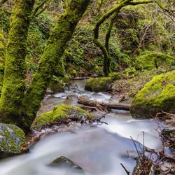
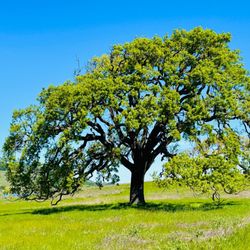
To get to this trail you must exit city life as you know it, then cross over to the dirt road. The preserve features a path which meanders through Oak and Redwood trees, a diversity of ferns and moss. After walking a little ways on the trail, you'll come upon a sign post. One direction says 'trail' the other says 'Big Trees'. I wanted to see what the Big Trees looked like so I took this path. I'd say it's a good 5-6 mile hike. It's not loop so you come back the way you came. There is a fire road that continues the trail, making it a 10 mile hike start to finish. After speaking with local hikers at the end of my hike, that I found I should have continued on this road. But it is at this junction where the Big Trees live. Like something out of a movie where upon exiting the forrest you step out to a verdant clearing, then BAMM! a group of gargantuan redwoods are in your sight. Not many people on this trail, in fact it was probably every 30 minutes before I saw other hikers. So your company are the Ravens, the Gray Squirrels, Salamanders and the trees. At one point you're fully surrounded by Oak, then the floor turns a bright red from the leaves of the Redwood, then you're with the Oaks again. Surrounding the preserve are rolling hills, which when not in drought would undoubtedly be lush with tall grass. This is a very easy hike with lots of switchbacks. Only at the very end is there a push in elevation, no doubt easily accomplished by anyone with a few extra deep breaths. Once you make it to the top you will be rewarding with an amazing view of Novato, San Pablo Bay and Petaluma off in the distance.

I realized I have not been on this hike in several years and decided today was the day to revisit. I've enjoyed this area in the past and I certainly remembered how pretty it was once we got going. Most of this hiking trail is shaded, which is helpful on the warmer days- however a few parts are out in the open. The trails are very well maintained, which is much appreciated. The views of Stafford Lake on one side of the hill and then looking towards the East Bay & Mount Diablo on the other side are both sensational. Dogs on leash are permitted. read more


This hiking trail is located pretty far out down Vineyard Road which goes on forever and in an area that many Novato locals don't even know exists. There is a horse stable at the end of the road and people horseback ride through the trails. Be ready to dodge lots of horse poop. It's very calm and peaceful up here, it's not nearly as busy as many other Marin hiking trails. Parts of the trail look out to views of Mount Burdell and Stafford Lake. The main loop (Upper Meadow with Big Trees) is about 4 miles and takes about 2 hours. It isn't too difficult, but it does have about a 650ft steady elevation gain so you are constantly going uphill until the top where you loop around and descent. Most of it is shaded, but I'd still skip it in the summertime, unless going early in the morning. There are a couple of trails where you can branch out more at the top. I've tried the Ships Mast which ended up on the residential Rebo Drive. I wouldn't recommend that unless you had sturdy boots or hiking poles. When it turns into Indian Tree fire road there are parts that are STEEP. This is actually good if you want something rigorous for your calves on the way up but for the descent there were some parts I thought that were downright dangerous for slipping even with running shoes. There are a couple of trails on the AllTrails app that in person are overgrown and closed with signs saying 'H Ranch keep out'. Still can't figure out who owns H Ranch but I've seen signs like that at the Fairway waterfall and Indian Valley Preserve. read more


Listen, if you're tired of constantly escaping the paparazzi, as most of us experience, then you may want to drive out to the isolated western part of Novato and hike the trails in this heavily wooded preserve. Trust me, nobody will find you here, and frankly I had trouble finding the open space since there was no parking lot and a small sign hardly visible from the road. In fact, I found myself on a gravel road in the middle of a horse stable. Once I finally found the Big Trees Trailhead, I began a slow and steady walk that became a gradual ascent through a wide variety of trees. It was quite manageable through a series of lengthy switchbacks. This pattern lasted for a couple of miles before I reached the first directional sign. What a welcome sight as I was growing weary of looking at the same foliage over and over again. Here I diverted myself to the Deer Camp Trail which turned my hike into a more circuitous path where I felt the prospect of seeing my car again increased significantly. My major challenges during this stretch were piles of horse manure and indeed the occasional equestrian where I had to yield perilously on a ledge since the trail became quite narrow. I made another right onto the Upper Meadow Trail where yes, civilization felt imminent. No autographs please. RELATED - Exploring north of San Francisco? Here's a collection of places I've visited and reviewed: https://bit.ly/2OrC8nU read more


It was absolutely beautiful. The trails were all cleared off very well lots of trees, outstanding view. Dogs and horses are welcome. It was my first time here and they do have a map at the beginning but I would've liked a few more signs along the way or trail markings. Not a lot of people so probably obvious good to bring someone with you. Great hike can't wait to go again! read more


I went on a hike w/ Greenbelt Alliance to Indian Tree OSP in Novato. First time there and I really enjoyed it. It's about 1hr10min from Fremont. No water so bring your own. No toilets - there is a grocery store and Starbucks off the freeway that is convenient. No bikes allowed I think because it's mostly single track trails and horses are on the trail along with hikers. Dogs allowed on leash. Limited roadside parking on Vineyard Rd. We started on the Upper Meadow Trail - Big Trees Trail, lots of gradual uphill on switchbacks - had lunch with a nice view near the Big Trees - then we took the Deer Camp Trail & Deer Camp Cutoff back to Upper Meadow Trail and the cars. I think it was about 5-6 miles total. We saw a snake, not much else. Worth a day trip if in the area or wanting to explore something new. read more


6 years ago
It's a real shame mountain biking isn't allowed. This area attracts only a handful of hikers and equestrians--it is sure beautiful. The grade couldn't be lovelier, it's always interesting with diverse flora: irises, ferns, Oak, California Bay, Buckeye, Redwood. Loop is about 2.5 hours hike. Midway up you hit chaparral with manzanita, madrone, and a view south, it's breathtaking. The coast redwood at the summit is a specimen that will leave you in awe every time. read more


12 years ago
To get to this trail you must exit city life as you know it, then cross over to the dirt road. The preserve features a path which meanders through Oak and Redwood trees, a diversity of ferns and moss. After walking a little ways on the trail, you'll come upon a sign post. One direction says 'trail' the other says 'Big Trees'. I wanted to see what the Big Trees looked like so I took this path. I'd say it's a good 5-6 mile hike. It's not loop so you come back the way you came. There is a fire road that continues the trail, making it a 10 mile hike start to finish. After speaking with local hikers at the end of my hike, that I found I should have continued on this road. But it is at this junction where the Big Trees live. Like something out of a movie where upon exiting the forrest you step out to a verdant clearing, then BAMM! a group of gargantuan redwoods are in your sight. Not many people on this trail, in fact it was probably every 30 minutes before I saw other hikers. So your company are the Ravens, the Gray Squirrels, Salamanders and the trees. At one point you're fully surrounded by Oak, then the floor turns a bright red from the leaves of the Redwood, then you're with the Oaks again. Surrounding the preserve are rolling hills, which when not in drought would undoubtedly be lush with tall grass. This is a very easy hike with lots of switchbacks. Only at the very end is there a push in elevation, no doubt easily accomplished by anyone with a few extra deep breaths. Once you make it to the top you will be rewarding with an amazing view of Novato, San Pablo Bay and Petaluma off in the distance. read more


10 years ago
Gorgous space, well worth the drive from San Francisco to explore. It is an easy hike and the trail is well-maintained. I appreciated that the people that brought their dogs were good about keeping them on a leash. GPS location on Google maps is a bit off; it says to drive past the horse stables, which you cannot do. Park once the paved road abruptly turns into a dirt road. If you want to see a ferns and Redwoods, use the trail on the left. read more


10 years ago
13 years ago

More info about Indian Tree Preserve
Vinyard Rd
Novato, CA 94947
Directions
Visit Website
https://www.marincountyparks.org/parkspreserves/preserves/indian-tree
Hours
Indoor Amenities
Outdoor Amenities
Ask the Community - Indian Tree Preserve
Review Highlights - Indian Tree Preserve
You might also consider


Why does Yelp recommend reviews?
1 review that is not currently recommended
The reviews below are not factored into the business's overall star rating.
5 years ago
Indian Tree Preserve - hiking - Updated August 2026
Best of Novato
People found Indian Tree Preserve by searching for…
Trending Searches in Novato, CA
Blueberry Picking near Indian Tree Preserve
Boardwalk near Indian Tree Preserve
Boating near Indian Tree Preserve
Cinema near Indian Tree Preserve
Cliff Jumping near Indian Tree Preserve
Cruising Spots near Indian Tree Preserve
Day Trips near Indian Tree Preserve
Dog Friendly Beaches near Indian Tree Preserve
Dog Friendly Things To Do near Indian Tree Preserve
Flower Fields near Indian Tree Preserve
Free Picnic Areas near Indian Tree Preserve
Jet Skis near Indian Tree Preserve
Kayak Rental near Indian Tree Preserve
Kids Activities Indoor near Indian Tree Preserve
Lakes near Indian Tree Preserve
Lookout Points near Indian Tree Preserve
Outdoor Activities near Indian Tree Preserve
Parks near Indian Tree Preserve
Peach Picking near Indian Tree Preserve
Playgrounds near Indian Tree Preserve
Public Beaches near Indian Tree Preserve
River Swimming near Indian Tree Preserve
Rock Quarry near Indian Tree Preserve
Scenic Drive near Indian Tree Preserve
Sunrise View near Indian Tree Preserve
Surf Shop near Indian Tree Preserve
Swimming Holes near Indian Tree Preserve
Things To Do On A Rainy Day near Indian Tree Preserve
Things To Do With Kids near Indian Tree Preserve
Watch Sunset near Indian Tree Preserve
Water Parks near Indian Tree Preserve
Browse Nearby
BEST of Novato, California Restaurants near Indian Tree Preserve
BEST of Novato, California Coffee near Indian Tree Preserve
BEST of Novato, California Things to Do near Indian Tree Preserve
BEST of Novato, California Breakfast near Indian Tree Preserve
BEST of Novato, California Wineries near Indian Tree Preserve
Browse Brands
Related Searches in Novato, CA
Affordable Kayak Rental Services in Novato, California
Best Dog Hiking Trails Around Novato, California
Best Fishing Locations and Guides in Novato, California
Best Nature Trails for Hiking in Novato, California
Best Off Leash Dog Parks in Novato, California
Best Parks for Parties and Events in Novato, California
Best Places for Horseback Riding in Novato, California
Best Sightseeing Experiences Available in Novato, California
Best Water Parks for Kids in Novato, California
Check Out Great Playgrounds in Novato, California
Check Out Off Road Trails in Novato, California
Discover Baseball Fields Around Novato, California
Discover Dog Friendly Trails to Explore in Novato, California
Discover Easy Hiking Trails Near Novato, California
Discover Fun Toddler Parks in Novato, California for Your Little One
Discover Kid Friendly Hiking Trails in Novato, California
Discover Lakes & Ponds to Explore in Novato, California
Discover Popular Bike Trails in Novato, California
Discover Soccer Fields in Novato, California Near You
Discover Top Nature Parks to Visit in Novato, California
Discover Top State Parks to Visit in Novato, California
Discover Walking Parks in Novato, California Near You
Discover a Hiking Trail in Novato, California
Discover the Best Beaches in Novato, California
Discover the Best Kids Park Spots in Novato, California
Discover the Best Night Hike Trails in Novato, California
Dog-Friendly Hikes With Dogs in Novato, California
Enjoy Camping Adventures Around Novato, California
Enjoy Kayaking Adventures in Novato, California
Enjoy Off Leash Dog Hikes in Novato, California
Enjoy Scenic Places to Walk in Novato, California
Enjoy a Beautiful Waterfall Hike in Novato, California
Enjoy the Best Picnic Spots and Ideas in Novato, California
Enjoy the Best Walking Path in Novato, California
Enjoy the Best Walking Trails in Novato, California
Explore Beautiful Parks and Green Spaces in Novato, California
Explore Easy Hikes Perfect for All in Novato, California
Explore Free Picnic Areas Around Novato, California
Explore Fun Activities to Do in Novato, California
Explore Parks With Pull Up Bars in Novato, California
Explore Picnic Parks Near Novato, California
Explore Popular Campgrounds Near Novato, California
Explore Popular Dog Walking Trails in Novato, California
Explore Popular Kids Parks Throughout Novato, California
Explore Popular Picnic Areas Around Novato, California
Explore Popular RV Parks Around Novato, California
Explore Scenic Lakes to Visit in Novato, California
Explore Top Dog Parks in Novato, California Near You