Steep Ravine Trail Photos


More like Steep Ravine Trail
Recommended Reviews - Steep Ravine Trail
Start your review...

Reviews With Photos

This is an awesome trail with scenic views for days. The name describes the trail. The trail is different in the way that it descends and keeps going down for the first half. Expect a lot of greenery and water streams. The trail is about 5 miles and I would say is moderately difficult. If you keep going you will eventually end up at Stinson beach. There is one parking lot at the trailhead but it fills up fast. Another parking lot is a short 0.5 mile walk away. Parking is $8, cash only. Be careful on the way there cause there are a lot of bicycles taking up the road. For sure not a trail for small children or pets.

I've done some intense hikes and the loop from old mine and Dipsea and up Steep Ravine is intense. There were beautiful ocean views and what seemed like a rainforest under the massive redwoods and a beautiful stream. The ladder was very unique. This trail gets super crowded and parking is insane. I prefer Cataract Falls for the scenery and payout for the effort.

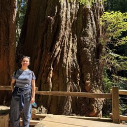
Insanely GORGEOUS!!! Now THIS is my kinda hiking trail, folks! Redwood heaven right before your eyes. Hiked the Steep Ravine Trail in conjunction with the Matt Davis and Dipsea trails for a loop, and I instantly fell in love with this part of the hike. This was definitely my favorite stretch of the loop. And, how could it not be?! You're basically hiking through a lusciously green meadow lined with the most vibrant plants and the most gorgeous Redwood trees. The peaceful sounds of the water running through the creek will gently sing to your ears as you meander through this stunning little forest. If you're lucky, you'll even be able to spot the little waterfall nearby. I mean, it's so gorgeous that it just downright looks fake. Oh, but it's real alright! A real beauty for sure. It seems like the popular way to get here is by hiking up the steps through the Dipsea trail from Stinson Beach. I decided to go the opposite way and take the Matt Davis Trail up and then reward myself by coming down through the Steep Ravine. Totally worth it either way that you go, but I feel like I'd do this loop the exact same way again. If you're coming from the Dipsea trail, the inclines through the Steep Ravine are pretty gentle. You'll also get to climb up the famous latter this way! I had to climb down it which was kind of tricky, but I made it work. It's so peaceful and serene. This is a popular trail, so if you're on it during the afternoon, you'll be sharing it with quite a few other people. But, it won't be so crowded that you can't enjoy it. This has easily become of my favorite Marin hiking trails! It's simply beautiful. Would recommend to anyone who is looking for a gorgeous trail to explore.

A beautiful hike with lush greenery and running water stream. It took about 3.5 hours with small breaks round-trip. We started at Stinson beach (free parking), hiked uphill on Steep Ravine, and returned back down on Dipsea Trail with ocean views. It is a moderate level of difficulty, though any level of hiking experience can be suitable for all.

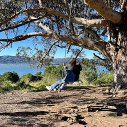
Steep Ravine Trial is awesome. Me and my friends went here recently. Had the whole trial to ourselves. Epic views of the ocean and rugged cliffs. Breathtaking views and perfect for a nice hike. The air here is super fresh. There are cabins right by the ocean yet the park ranger said need to be booked six months ahead of time. They run around $100 a night up to five people. Apparently there is a hot springs in a cave near the ocean as well yet only available certain times of year and only during low tide. Can't go wrong with a hike here.

"Jungle, Ladder, Nudist Beach?" When I asked my hiking friends what they thought was the most memorable Trail in the Bay Area, many of them mentioned Steep Ravine. This trail has some interesting history. For one thing, the famous artist Thaddeus Welch and his artist wife had a cabin here about a hundred years ago. I really wanted to find the location for the cabin, but I never really succeeded. The artist is the one who came up with the name Steep Ravine. I came here on a mild October morning. At 7:15 I found plenty of parking spaces at Pantoll campground. The trailhead is clearly marked at the back of the campground. It's easy to see why this is a favorite. It's a lush trail with tons of vegetation. It's like being in a forest! Be aware that it is fairly steep and uneven at places. Of course, there is the fun ladder to descend as well. Just be careful and you will be okay. It's easy to make a loop. I decided to come back on the Dipsea trail. Both trails are equally interesting and lush green. But the Dipsea Trail does not have a ladder. Near the junction with Dipsea, there is a fire road that leads to another historical place. It is an old Army artillery site close by. There's a few interesting artifacts to see there as well. You exit Steep Ravine trail at Highway 1. If you wish you can cross the highway and go see the Steep Ravine cabins there as well. It's a bit more of a hike, but I thought it was worthwhile. Pretty close to the Steep Ravine cabin is a small beach, which turns out to be a nudist beach. I wanted to go see it, but my wife told me I was not allowed to. Plus, I wasn't sure how I was going to write a Yelp review about a nudist beach. Would I be allowed to upload photos or video? Anyway, the beach seemed to be deserted. I was hoping to see some people, just so that I could confirm it was a nudie beach. Just think if you thought it was a nudist beach but it turned out not to be after you arrived. So all in all, the Steep Ravine Trail is well worth seeing. Be sure to come early to get a parking spot. If you happen to go to the nudie Beach, please tell me how it worked out.

We had such a good time on this hike! Almost the entire trail has tree cover overhead, which provides shade from the heat and some quiet from the nearby road. The cool air, the green canopy above, the beautiful water flowing alongside you, the rock steps and bridges all coalesce into a memorable scene. The trail is not very difficult with a nice distinct path for the majority of the hike. We saw all ages along the way. As long as you don't have a problem with stairs, you should be good. We hiked to the manmade ladder structure before turning back, but that was enough to leave a lasting impression on me. I hope we can come back to do this one a second time.

We did a roughly 7 mile circuit of Dipsea/Steep Ravine/Matt Davis, starting and ending in Stinson Beach. Moderately challenging hike - the steep ravine part probably had the most uphill grade - with very varied scenery along the way so never a boring moment. Compared to east coast trails most of the trail surface's squite even and not very rocky. At about 2/3 of the way we stopped on a hilltop to rest and have lunch - good spot for a view of the skyline of San Francisco. Closer to the end there was another smaller rock outcropping for a view of the town of Stinson Beach. The trails are all well maintained and marked and there are longer and shorter variations suitable for all levels and abilities.

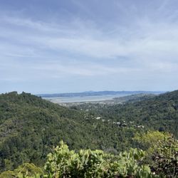
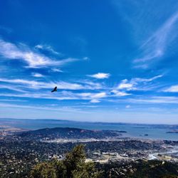
After a particularly rough week, the great outdoors was calling. I was looking for a hike that would be moderately challenging, not super long and involved a variety of terrains and scenery. The Steep Ravine Trail fit the bill perfectly! Following directions to the Pantoll Ranger Station, we arrived to a full lot. After doing a loop, we snagged a spot from someone leaving and paid the $8 to park for day use. Super helpful ranger helped us map out our route and off we went. Following the Old Mine Trail, we didn't turn right on the Dipsea right away, but instead followed that a bit more to the east and connected with the Dipsea route in the direction of Muir Woods. It's not the path to take if you are just doing the Dipsea/Steep Ravine Trail, but we veered off course a bit just to get a feel for the other trail heads in the area. After having our fill of that route, we doubled back and began the loop hike in earnest. The first part of the Dipsea trail after the Old Mine is open with expansive views of the coast. We saw the fogline and all the way out to the Sutro Tower-pretty epic and amazing. After scrambling down a narrow trail with chapparl you start to head down in to the forest. For the rest of the hike, it's a wonderland of redwoods, ferns, streams, footbridges and stairs. Once you reach the bottom of the Dipsea you will see a clearly marked sign to the Steep Ravine trail, which runs about 1.7 miles back towards the Pantoll station. There is a creek (which was down to a trickle but still present) that runs along the trail and what appear to be some small waterfalls (hard to tell in this drought but come winter, I can imagine it's all quite magical.) With several miles behind us, the hike back up through Steep Ravine was somewhat challenging (not strenuous, but at the tail end of our hike, we felt every step up that hill.) We made it to the infamous ladder, which is actually quite easy to scramble up and then after that just wound our way back up to the ranger station and campground. If you do the Old Mine Trail (which you can pick up immediately to the right of the restrooms) to Dipsea to Steep Ravine, I believe it's about a 3.9 mile loop. However, as we did, you can connect with a variety of other trails and I even saw signs indicating the distance to Muir Woods. There were plenty of other folks on the trail, but it wasn't overcrowded either. With clean restrooms, maps and easy access to the playground that is Mt. Tamalpais, the Steep Ravine Trail via Pantoll is a moderate and wonderous shorter hike. I can't wait to go back after some rain and experience the creek in winter or spring. Other tips: Bring plenty of water (although much of the hike is shaded, the up & down creep up on you,) layer (it was cooler in the forested areas,) take care with your footing-some of the stairs were damp and slippery and go with a buddy (while it seems like a safe and well traveled trail, there are a lot of rocks and roots and drop offs-so best to be with someone who can look out for you.) Enjoy and have fun!

This is a truly magical hike, that starts either at the Pantoll Ranger Station or at the South/East edge of Stinson. (I prefer to start at the Pantoll Ranger Station, go down to Stinson on Matt Davis Trail, have lunch in town, go to the ocean, and head back up Steep Ravine.) The trailhead from Stinson end is marked as "To Dipsea"--but once you're 20 minutes in to the hike you'll start to see the signs for Steep Ravine. The actual trail begins right at the base of a creek and seasonal pond. From there starts an incredible grove of redwoods that goes up the entire way to the ranger station. It's a journey through twists and turns, moss-covered giants, fallen trees, and trickling waterfalls. There's a ladder at one point (only way up a rocky part)--so it's not wheelchair accessible, and not good for little kids. Go in late spring when you'll see all the shades of green Marin has to offer. You'll be glad you did! I've taken a few out-of-town guests on this hike--and they've all been amazed. (Especially Oregonians: "Wow, there's no place in Oregon in which you can hike for two hours to a town for a great lunch, then see redwoods!")

Fun hike! Went around 9 or 10am on a Saturday morning. The weather was perfect. I mainly wanted to come here to see the famous ladder, but ended up going all the way down to Stinson beach and back. Parking can be tricky..the lot closest to the trail gets filled pretty quickly, so try to get here early! Beautiful trail in general.. Some mini waterfalls, and tons of towering trees. Worth the sore muscles :0) check this place out! Ps. There's a geocache hidden somewhere along this trail! Keep your eyes open ;)

1 year ago
I just hiked most of this trail yesterday, and it was lit. I hiked the section from Pantoll Ranger Station to Dipsea, and to Stinson Beach from there. I looped back up on the Matt Davis Trail. Steep Ravine is famous, or at least locally famous, for its ladder up the side of a waterfall. On this occasion, it was slippery and wet, and was missing two of its rungs. Last time, I went up, but this time, I went down, which I think was way scarier. I would definitely not want to do this in the rain. As it was, I clung to the ladder with my whole body, and still felt like I was gonna slip. I became covered in mud, as a warning to all the other hikers passing in the other direction of what was to come. There are so many gorgeous little waterfalls on Webb Creek on this trail. Hiking through this forest almost feels like traveling back in time. It's so beautiful. I thought a heard a few fish splashing up the creek, but didn't see any. It looks like a salmon paradise, with hundreds of shallow pools connected by tiny cascades. Very hard but very rewarding trail. Make sure to bring food and water, since there isn't any water on the trail, and the only food is in Stinson Beach. read more


This time we started with the Steep Ravine and came back via the Dipsea Trail- great choice! Beauty surrounds you the entire hike. Be prepared to hike up many, many steps on Dipsea. So many gorgeous spots for photos and a lunch break. Fantastic map of area at the Pantoll Ranger Station (he was super nice & kind of cute). The entire area is very well maintained (Support your Parks!). Next time I think we shall start our hike at Stinson Beach. read more


I love this hike because the trail is so lush and forested. It's around 4 miles but down and back but some people could take 2 cars and park at the other entrances on Shoreline or Panoramic which might be good to cut it in half for people that can't hike that far. The main entrance is at the Pantoll campground which isn't too big. If the lot is full, you can go higher up Pan Toll Road where there are pockets of land to park but since it's a paved road just be careful to watch out for cars and especially bikes that come whizzing down. The weekend brings lots of people, it can get crowded, but the weekdays are better if you can swing it because you have more of the forest to yourself. The ladder is about 1 mile from the Pantoll parking lot, it's the only waterfall I know in Marin that has a ladder. During the weekend it's harder to get photos of the ladder and waterfall without getting other hikers in it. read more


This is an awesome trail with scenic views for days. The name describes the trail. The trail is different in the way that it descends and keeps going down for the first half. Expect a lot of greenery and water streams. The trail is about 5 miles and I would say is moderately difficult. If you keep going you will eventually end up at Stinson beach. There is one parking lot at the trailhead but it fills up fast. Another parking lot is a short 0.5 mile walk away. Parking is $8, cash only. Be careful on the way there cause there are a lot of bicycles taking up the road. For sure not a trail for small children or pets. read more

I've done some intense hikes and the loop from old mine and Dipsea and up Steep Ravine is intense. There were beautiful ocean views and what seemed like a rainforest under the massive redwoods and a beautiful stream. The ladder was very unique. This trail gets super crowded and parking is insane. I prefer Cataract Falls for the scenery and payout for the effort. read more


Insanely GORGEOUS!!! Now THIS is my kinda hiking trail, folks! Redwood heaven right before your eyes. Hiked the Steep Ravine Trail in conjunction with the Matt Davis and Dipsea trails for a loop, and I instantly fell in love with this part of the hike. This was definitely my favorite stretch of the loop. And, how could it not be?! You're basically hiking through a lusciously green meadow lined with the most vibrant plants and the most gorgeous Redwood trees. The peaceful sounds of the water running through the creek will gently sing to your ears as you meander through this stunning little forest. If you're lucky, you'll even be able to spot the little waterfall nearby. I mean, it's so gorgeous that it just downright looks fake. Oh, but it's real alright! A real beauty for sure. It seems like the popular way to get here is by hiking up the steps through the Dipsea trail from Stinson Beach. I decided to go the opposite way and take the Matt Davis Trail up and then reward myself by coming down through the Steep Ravine. Totally worth it either way that you go, but I feel like I'd do this loop the exact same way again. If you're coming from the Dipsea trail, the inclines through the Steep Ravine are pretty gentle. You'll also get to climb up the famous latter this way! I had to climb down it which was kind of tricky, but I made it work. It's so peaceful and serene. This is a popular trail, so if you're on it during the afternoon, you'll be sharing it with quite a few other people. But, it won't be so crowded that you can't enjoy it. This has easily become of my favorite Marin hiking trails! It's simply beautiful. Would recommend to anyone who is looking for a gorgeous trail to explore. read more


2 years ago
A beautiful hike with lush greenery and running water stream. It took about 3.5 hours with small breaks round-trip. We started at Stinson beach (free parking), hiked uphill on Steep Ravine, and returned back down on Dipsea Trail with ocean views. It is a moderate level of difficulty, though any level of hiking experience can be suitable for all. read more


1 year ago
Steep Ravine Trial is awesome. Me and my friends went here recently. Had the whole trial to ourselves. Epic views of the ocean and rugged cliffs. Breathtaking views and perfect for a nice hike. The air here is super fresh. There are cabins right by the ocean yet the park ranger said need to be booked six months ahead of time. They run around $100 a night up to five people. Apparently there is a hot springs in a cave near the ocean as well yet only available certain times of year and only during low tide. Can't go wrong with a hike here. read more


"Jungle, Ladder, Nudist Beach?" When I asked my hiking friends what they thought was the most memorable Trail in the Bay Area, many of them mentioned Steep Ravine. This trail has some interesting history. For one thing, the famous artist Thaddeus Welch and his artist wife had a cabin here about a hundred years ago. I really wanted to find the location for the cabin, but I never really succeeded. The artist is the one who came up with the name Steep Ravine. I came here on a mild October morning. At 7:15 I found plenty of parking spaces at Pantoll campground. The trailhead is clearly marked at the back of the campground. It's easy to see why this is a favorite. It's a lush trail with tons of vegetation. It's like being in a forest! Be aware that it is fairly steep and uneven at places. Of course, there is the fun ladder to descend as well. Just be careful and you will be okay. It's easy to make a loop. I decided to come back on the Dipsea trail. Both trails are equally interesting and lush green. But the Dipsea Trail does not have a ladder. Near the junction with Dipsea, there is a fire road that leads to another historical place. It is an old Army artillery site close by. There's a few interesting artifacts to see there as well. You exit Steep Ravine trail at Highway 1. If you wish you can cross the highway and go see the Steep Ravine cabins there as well. It's a bit more of a hike, but I thought it was worthwhile. Pretty close to the Steep Ravine cabin is a small beach, which turns out to be a nudist beach. I wanted to go see it, but my wife told me I was not allowed to. Plus, I wasn't sure how I was going to write a Yelp review about a nudist beach. Would I be allowed to upload photos or video? Anyway, the beach seemed to be deserted. I was hoping to see some people, just so that I could confirm it was a nudie beach. Just think if you thought it was a nudist beach but it turned out not to be after you arrived. So all in all, the Steep Ravine Trail is well worth seeing. Be sure to come early to get a parking spot. If you happen to go to the nudie Beach, please tell me how it worked out. read more


5 years ago
We had such a good time on this hike! Almost the entire trail has tree cover overhead, which provides shade from the heat and some quiet from the nearby road. The cool air, the green canopy above, the beautiful water flowing alongside you, the rock steps and bridges all coalesce into a memorable scene. The trail is not very difficult with a nice distinct path for the majority of the hike. We saw all ages along the way. As long as you don't have a problem with stairs, you should be good. We hiked to the manmade ladder structure before turning back, but that was enough to leave a lasting impression on me. I hope we can come back to do this one a second time. read more


We did a roughly 7 mile circuit of Dipsea/Steep Ravine/Matt Davis, starting and ending in Stinson Beach. Moderately challenging hike - the steep ravine part probably had the most uphill grade - with very varied scenery along the way so never a boring moment. Compared to east coast trails most of the trail surface's squite even and not very rocky. At about 2/3 of the way we stopped on a hilltop to rest and have lunch - good spot for a view of the skyline of San Francisco. Closer to the end there was another smaller rock outcropping for a view of the town of Stinson Beach. The trails are all well maintained and marked and there are longer and shorter variations suitable for all levels and abilities. read more


5 years ago
4 years ago
11 years ago
After a particularly rough week, the great outdoors was calling. I was looking for a hike that would be moderately challenging, not super long and involved a variety of terrains and scenery. The Steep Ravine Trail fit the bill perfectly! Following directions to the Pantoll Ranger Station, we arrived to a full lot. After doing a loop, we snagged a spot from someone leaving and paid the $8 to park for day use. Super helpful ranger helped us map out our route and off we went. Following the Old Mine Trail, we didn't turn right on the Dipsea right away, but instead followed that a bit more to the east and connected with the Dipsea route in the direction of Muir Woods. It's not the path to take if you are just doing the Dipsea/Steep Ravine Trail, but we veered off course a bit just to get a feel for the other trail heads in the area. After having our fill of that route, we doubled back and began the loop hike in earnest. The first part of the Dipsea trail after the Old Mine is open with expansive views of the coast. We saw the fogline and all the way out to the Sutro Tower-pretty epic and amazing. After scrambling down a narrow trail with chapparl you start to head down in to the forest. For the rest of the hike, it's a wonderland of redwoods, ferns, streams, footbridges and stairs. Once you reach the bottom of the Dipsea you will see a clearly marked sign to the Steep Ravine trail, which runs about 1.7 miles back towards the Pantoll station. There is a creek (which was down to a trickle but still present) that runs along the trail and what appear to be some small waterfalls (hard to tell in this drought but come winter, I can imagine it's all quite magical.) With several miles behind us, the hike back up through Steep Ravine was somewhat challenging (not strenuous, but at the tail end of our hike, we felt every step up that hill.) We made it to the infamous ladder, which is actually quite easy to scramble up and then after that just wound our way back up to the ranger station and campground. If you do the Old Mine Trail (which you can pick up immediately to the right of the restrooms) to Dipsea to Steep Ravine, I believe it's about a 3.9 mile loop. However, as we did, you can connect with a variety of other trails and I even saw signs indicating the distance to Muir Woods. There were plenty of other folks on the trail, but it wasn't overcrowded either. With clean restrooms, maps and easy access to the playground that is Mt. Tamalpais, the Steep Ravine Trail via Pantoll is a moderate and wonderous shorter hike. I can't wait to go back after some rain and experience the creek in winter or spring. Other tips: Bring plenty of water (although much of the hike is shaded, the up & down creep up on you,) layer (it was cooler in the forested areas,) take care with your footing-some of the stairs were damp and slippery and go with a buddy (while it seems like a safe and well traveled trail, there are a lot of rocks and roots and drop offs-so best to be with someone who can look out for you.) Enjoy and have fun! read more


16 years ago
This is a truly magical hike, that starts either at the Pantoll Ranger Station or at the South/East edge of Stinson. (I prefer to start at the Pantoll Ranger Station, go down to Stinson on Matt Davis Trail, have lunch in town, go to the ocean, and head back up Steep Ravine.) The trailhead from Stinson end is marked as "To Dipsea"--but once you're 20 minutes in to the hike you'll start to see the signs for Steep Ravine. The actual trail begins right at the base of a creek and seasonal pond. From there starts an incredible grove of redwoods that goes up the entire way to the ranger station. It's a journey through twists and turns, moss-covered giants, fallen trees, and trickling waterfalls. There's a ladder at one point (only way up a rocky part)--so it's not wheelchair accessible, and not good for little kids. Go in late spring when you'll see all the shades of green Marin has to offer. You'll be glad you did! I've taken a few out-of-town guests on this hike--and they've all been amazed. (Especially Oregonians: "Wow, there's no place in Oregon in which you can hike for two hours to a town for a great lunch, then see redwoods!") read more


10 years ago
Fun hike! Went around 9 or 10am on a Saturday morning. The weather was perfect. I mainly wanted to come here to see the famous ladder, but ended up going all the way down to Stinson beach and back. Parking can be tricky..the lot closest to the trail gets filled pretty quickly, so try to get here early! Beautiful trail in general.. Some mini waterfalls, and tons of towering trees. Worth the sore muscles :0) check this place out! Ps. There's a geocache hidden somewhere along this trail! Keep your eyes open ;) read more


8 years ago
Came to see the wooden ladder! One of the many hikes that will lead you to Stinson Beach should you choose to venture a more challenging path. Sadly, I didn't have the time that day to walk all the way down. My friend and I came down here early afternoon last Saturday after visiting Mt. Tam East Peak (10 minute drive up), and boy was the parking lot packed. I was fortunate enough to find off road parking 10-15 minutes away! Probably better to come here earlier rather than later, but at least I avoided the parking fee. Pantoll Campground is the main lot that leads to a lot of other local trails as well, but the Steep Ravine Trail is the one with the famous wooden ladder. As we made our way down, we noticed a lot of ferns and some redwoods spread alongside Webb Creek. Sadly there wasn't a strong flow when I went. The ladder is located about 2 miles down from the campground so not too bad compared to the entire 6.5 mile loop back to the Matt Davis Trail. The ladder is sturdy and rests against a giant boulder. The steepness and rise between steps reminds me of the moon bridge found in the SF Japanese Garden. Wish I completed the entire loop though, but will save that for another time. read more

My only regret was not coming here early enough to actually finish the hike. Otherwise, it's a great place to hike! You get to see so much throughout - the water, the hills, the forest-y area, etc. Each part that you walk or run into feels like you're in a different place. For the most part, the hike wasn't particularly hard - and that's measured by how out of shape I am, so you'll probably be okay. It does range though - it's flatish in some places, hillier in others and at times there are stairs. But overall, it's a great hike because there is a lot of variety. read more


12 years ago
I've recently hiked this with a friend because I was so curious as to why people loved it so much. Now I see why! This place is a beauty, and I love that for the very first time ever, I wasn't lost. The trees are lusciously green despite the water drought. Just wish I could see more water and creeks in the future IF the drought is ever over. When I first drove here, it was quite confusing to find the place, so I kept driving until I saw a huge parking lot with people there only to find you have to pay $8 to park here. I believe it was at the Pantoll Ranger Station. Not too bad since the staff directed me to where the trail was supposed to start. We didn't continue the trail after seeing the huge ladder, instead we just hiked back, and went on the Old Mine Trail to check out the bench area. It was a good day to hike for us despite the small fog that came by afterwards; however, I would love to explore many other possibilities and trails the next time I come! read more


10 years ago
After a relaxing lunch and nap at Stinson beach, my SO and I took this trail back to the Pantoll Ranger Station. It took us about two hours in combination with the Dipsea trail. If this trail wasn't in the Bay Area, it would have definitely kicked my ass. I'm extremely grateful for the cool temperature and the occasional breeze while climbing all those steps. The view is beautiful, you get to hike along a creek and be surrounded by lush greenery. Don't forget to bring plenty of water! read more


We did this hike from the Pantoll ranger station to Stinson Beach and back to the ranger station. Total hike was 10 miles. Tough but a nice hike. Most of the trail was shaded and stays cool. But when you get to the fire road going toward Stinson Beach there's no shade at all. My son's first ten mile hike and he loves it. I think this loop is the best loop in Mount Tam. Make sure you have $8 to park or you will get a ticket. Start early because the trail can get crowded. Bring lots of water if you're going to do the whole loop. Bring some snacks also. This hike will definitely challenge you. read more


Challenging topography, gorgeous views, and enough natural shade for even the hottest days. We linked a few trails together, but spent the most of our time on Steep Ravine Trail. There's lots of tiny waterfalls and the trail follows the flow of the water for a soothing soundtrack to your hike. There's also LOTS of stairs (up and down) and a ladder! This is probably one of my favorite trails so far! NOTE: $8 for parking (credit card only at the machine). read more


13 years ago
7 years ago
11 years ago
One of the best trails in the Bay Area! Bridges to cross, fallen trees to go under, ladders to climb and creeks to see and elevation changes to test your endurance. At the end, you get to a beautiful beach, Stinson beach. Recommend it for first time hikers! read more


10 years ago
Um wow! Absolutely beautiful. Came here over the weekend with my trainer and his 6 week new you challenge group and his crazy ass wants to speed through. haha I enjoy staring and taking photos of nature's beauty. So I was totally in the back of the line and looking like a straight Asian taking hella photos.. Then would have to run to catch up! hahah Such a beautiful hike.. Everywhere I looked there was something to look at.... mini streams, waterfalls, stone steps, wood steps (which are slippery so BE CAREFUL with your footing), twisted steps... tons of trails to lightly jog if you like......walls and steps covered in moss and fern peaking out every little corner. Fallen Tree stumps everywhere where you have to maneuver under... tons of brides to cross. Up and up and up you go....literally felt like fairy land. I absolutely loved this one. I think the total hike is around 9 miles? It ends up to Stinson beach. Where you can lounge around. There's a cute little town where you walk through before you hit the beach. Buy food and chill or buy food and go sit on the beach. Instead of going back to the trail. (which I may do that next time I go) we walked to our car which was a little over a mile away and near the two lane highway... slightly scary walking near all that lol. BUT also very pretty to see the coast. All in all, great hike. difficulty? I say a 2-3 out of 5. But then again I have what's called Asthmatic Bronchitis .....so I kind of wheeze while I walk up lol. YES I had my inhaler .... so those who think they can't make it... you can... just go slow and listen to your body......... I will definitely come back again! read more


10 years ago
When we left our house for this trail we weren't sure as it was still raining but i guess it was the best decision it is a very beautiful trail.It passes through a deep Redwood forest and the loop is completed with lovely occean views.As it was raining the previous day there lots of waterfalls luckily it didnt rain while we were there.Must do read more


12 years ago
It was a fun first time hiking here. The trail that leads to the beach is beautiful. The sunset, the fog, and the sky form some kind of heaven. read more

15 years ago
8 years ago
Page 1 of 2
More info about Steep Ravine Trail
Mill Valley, CA 94941
Directions
Hours
Indoor Amenities
Outdoor Amenities
Ask the Community - Steep Ravine Trail
Where do you park to get here?
Pantoll Campground parking lot or Stinson Beach parking lot. There's another place near Stinson Beach where you can park in the dirt.
Review Highlights - Steep Ravine Trail


Why does Yelp recommend reviews?
Steep Ravine Trail - hiking - Updated June 2026
Best of Mill Valley
People found Steep Ravine Trail by searching for…
Natural Hot Springs in Mill Valley, California
Hiking Trails With Waterfalls in Mill Valley, California
Beaches in Mill Valley, California
Scenic View in Mill Valley, California
Watch Sunset in Mill Valley, California
Campgrounds in Mill Valley, California
Easy Hikes in Mill Valley, California
Free Campgrounds in Mill Valley, California
Parks in Mill Valley, California
Playgrounds in Mill Valley, California
Dog Friendly Hiking Trails in Mill Valley, California
Things to Do in Mill Valley, California
Free Parking in Mill Valley, California
Walking Trails in Mill Valley, California
Dog Friendly Beaches in Mill Valley, California
Redwood Trees in Mill Valley, California
Stairs Workout in Mill Valley, California
Redwood Forest in Mill Valley, California
Fishing in Mill Valley, California
Waterfalls in Mill Valley, California
Hiking Club in Mill Valley, California
Waterfalls and Swimming Holes in Mill Valley, California
Trending Searches in Mill Valley, CA
Black Owned Nail Salons near Steep Ravine Trail
Boat Rental near Steep Ravine Trail
Cliff Jumping near Steep Ravine Trail
Day Trips near Steep Ravine Trail
Dog Friendly Trails near Steep Ravine Trail
Fishing Spots near Steep Ravine Trail
Jet Ski Rental near Steep Ravine Trail
Kayak Rental near Steep Ravine Trail
Lakes & Ponds near Steep Ravine Trail
Off Road Trails near Steep Ravine Trail
Outdoor Activities near Steep Ravine Trail
Places To Walk Around near Steep Ravine Trail
Public Pools near Steep Ravine Trail
Public Shower near Steep Ravine Trail
River Swimming near Steep Ravine Trail
Rock Quarry near Steep Ravine Trail
Scenic Night View near Steep Ravine Trail
Scenic Overlook near Steep Ravine Trail
Secluded Spots near Steep Ravine Trail
Soccer Store near Steep Ravine Trail
Splash Pad near Steep Ravine Trail
Strawberry Picking near Steep Ravine Trail
Sunrise View near Steep Ravine Trail
Swimming Holes near Steep Ravine Trail
Swimming Lakes near Steep Ravine Trail
U Pick Farms near Steep Ravine Trail
Watch Sunset near Steep Ravine Trail
Browse Articles
Browse Nearby
BEST of Mill Valley, California Walking Trails near Steep Ravine Trail
BEST of Mill Valley, California Coffee near Steep Ravine Trail
BEST of Mill Valley, California Restaurants near Steep Ravine Trail
BEST of Mill Valley, California Things to Do near Steep Ravine Trail
BEST of Mill Valley, California Parks near Steep Ravine Trail
BEST of Mill Valley, California Breakfast near Steep Ravine Trail
BEST of Mill Valley, California Hot Springs near Steep Ravine Trail
BEST of Mill Valley, California Campgrounds near Steep Ravine Trail
BEST of Mill Valley, California Sightseeing near Steep Ravine Trail
Browse Brands
Related Searches in Mill Valley, CA
Affordable Kayak Rental Services in Mill Valley, California
Best Fishing Locations and Guides in Mill Valley, California
Best Nature Trails for Hiking in Mill Valley, California
Best Places for Horseback Riding in Mill Valley, California
Check Out Off Road Trails in Mill Valley, California
Discover Dog Friendly Trails to Explore in Mill Valley, California
Discover Kid Friendly Hiking Trails in Mill Valley, California
Discover Scenic Hiking Trails in Mill Valley, California
Discover Scenic Mountain Bike Trails Near Mill Valley, California
Discover Scenic Waterfall Spots in Mill Valley, California
Discover Top Nature Parks to Visit in Mill Valley, California
Discover Walking Parks in Mill Valley, California Near You
Discover a Hiking Trail in Mill Valley, California
Discover the Best Night Hike Trails in Mill Valley, California
Discover the Best Running Track in Mill Valley, California
Dog-Friendly Hikes With Dogs in Mill Valley, California
Enjoy Camping Adventures Around Mill Valley, California
Enjoy Kayaking Adventures in Mill Valley, California
Enjoy Tent Camping Spots Around Mill Valley, California
Enjoy a Beautiful Waterfall Hike in Mill Valley, California
Enjoy the Best Picnic Spots and Ideas in Mill Valley, California
Enjoy the Best Walking Path in Mill Valley, California
Enjoy the Best Walking Trails in Mill Valley, California
Exciting Cliff Jumping Spots in Mill Valley, California
Explore Beautiful Parks and Green Spaces in Mill Valley, California
Explore Easy Hikes Perfect for All in Mill Valley, California
Explore Fun Activities to Do in Mill Valley, California
Explore Popular Campgrounds Near Mill Valley, California
Explore the Best Beach Spots in Mill Valley, California
Explore the Best Swimming Holes Around Mill Valley, California
Explore the Best Trail Options in Mill Valley, California
Family Friendly Hiking With Kids in Mill Valley, California
Find Beautiful Views in Mill Valley, California
Find the Best Parks for Picnics in Mill Valley, California
Find the Best Scenic View Locations in Mill Valley, California
Great Places to Walk in Mill Valley, California
Hike the Popular Waterfall Trail in Mill Valley, California
Hiking Trails With Waterfalls in Mill Valley, California
Off Leash Dog Hiking Trails in Mill Valley, California
Plan a Scenic Drive Route Near Mill Valley, California
Popular Outdoor Activities to Try in Mill Valley, California
Popular Picnic Spots to Visit in Mill Valley, California
Safe River Swimming Areas in Mill Valley, California
Safe and Fun Parks for Kids in Mill Valley, California
Top Climbing Spots and Gyms in Mill Valley, California
Top Running Trails to Explore in Mill Valley, California
Top Swimming Lakes to Enjoy in Mill Valley, California
Top Swimming Spots and Pools in Mill Valley, California
Walk Dog Friendly Hiking Trails in Mill Valley, California
Walk the Best Paved Walking Trails in Mill Valley, California
People who viewed Steep Ravine Trail also viewed
Mount Tamalpais State Park
433 reviews
Muir Woods National Monument
1884 reviews
Tiburon Ridge Preserve
15 reviews
Morning Sun Trail
4 reviews
Lands End Trail
985 reviews
Sea Cliff
Hoo Koo E Koo Loop
8 reviews
Matt Davis-Steep Ravine Loop
91 reviews
Cascade Park
4 reviews
Slackers Hill
23 reviews
Old St. Hilary's Open Space Nature Preserve
12 reviews