Baltimore Canyon Photos


You might also consider
More like Baltimore Canyon
Recommended Reviews - Baltimore Canyon
Start your review...

Reviews With Photos - Baltimore Canyon

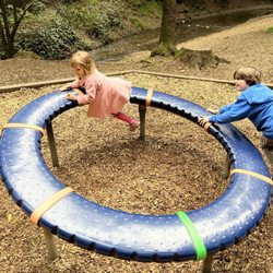
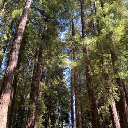
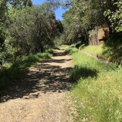
Nestled deep in downtown Larkspur, Baltimore Canyon offers something for everyone (runner, walkers, dog-owners, etc.). Although steep in parts, this isn't the most challenging of trails. Everything is well paved. Even a hiking novice will feel comfortable here. If you come here in the morning, you'll be rewarded with fresh air, friendly wildlife (birds, squirrels, and more), flowing cascades, and and other hidden nature surprises. When you trek through this breathtaking Redwood forest, you can't help but feel like you're a Hobbit traversing Middle Earth. Or, at the very least, you feel like you're on your way to the Ewok Village. Word to the wise - parking is very limited. It's best to park on the neighborhood streets a few blocks away. I always just park on Magnolia Street near Perry's Restaurant and Equator Coffee. From there, it's just a 15-minute stroll to the trailhead. After your hike, I'd recommend doing a picnic in Dolliver Park on Madrone Ave. They have plenty of tables, a playground for kids, and a public restroom (though I'm not sure it's open right now during this Corona Climate). As much as I love Muir Woods, Baltimore Canyon is truly my go-to choice for a wonderful walk in the woods with friends and my pooch. I hope you have the chance to experience it for yourself.

Perfect [mostly] shady trail for sunny days when you want to hike, but don't want to burn. I jogged downhills and shady areas, walked uphills and most sunny areas. Off of Magnolia in Larkspur, turn onto Madrone (only 1 way to turn) and go all the way down. Park within the established white parking spaces. There are 5 all the way at the end, and a few scattered further upward the road. I parked right where I wanted to be and jogged down. A couple really cute, typical Marin trail bridges, but surrounded by gorgeously tall redwoods. If you go during the winter/spring, you'll jog along the rustling Larkspur creek, which dries up during the summer/fall months. I took the main trail to the Lady Bug trail, then to the King's Mountain trail, which is a loop. Along the way, I passed a few other walkers, a couple joggers, a gorgeous man with two little dogs (must be wifed up), and an unexpected pretty stellar view of the North Bay toward the Richmond Bridge. Took me about 90 minutes RT. The King Mtn trail looped me back to almost where I started and I knew the way back from there. This is a go to for trail runners and someone who just wants to enjoy a peaceful walk. You never quite feel as insignificantly special as you do surrounded by luscious greenery that existed long before you, and will long survive you.

Baltimore Canyon is a wooded, fern covered vista. The first part of the hike is through a real low, wooded area full of man made switch backs pretty much until you get to the first plateau. Once you reach your first destination you get a pretty clear view of East bay- on a real clear day you can see part of the city. If the first stint hasn't got you out of breath you can hike up higher which is about another 5 miles. From that point you can see all over the bay and the views are breathtaking. Although this hike used to have small waterfalls and streams, the last time I went they were pretty dry. I would consider this a moderate to easy hike and the first stint is probably five miles round trip. Great for a Sunday afternoon!

I had forgotten how lovely this hike is. As we had some recent rain, there is still a creek flowing. However I think I would have to rename Dawn Falls to Dawn trickle. Although I don't own a dog, it was nice to see that this was a dog friendly trail. The head of the trail is in the depth of a forested, beautiful neighborhood. Parking can be challenging, but being a weekday we lucked out. We ended up doing a 5 mile out and back with maybe 500 feet of climbing. If we had more time, we would've continued up to King Mountain. Between the redwood trees, the creek the beautiful rocks and ferns the entire hike was delightful. read more


This is such a lovely trail in the heart of downtown Larkspur. But be aware they only have street parking, and it fills up pretty quickly on weekends. I love hiking here because the trail is easy and beautiful, and we can have our dog join us. People should have their dogs on leash, but unfortunately, we've encountered folks who flout that rule. Oh well! The scenery is beautiful, and the trail is less busy than other local comparable destinations. The bridges and redwoods make Baltimore Canyon a nature lover's paradise. There's just so much beauty to take in. I recommend coming in the late morning to early afternoon on a weekday when parking is still available, and the trail is sparsely traveled. read more
You don't have to go all the way to Muir Woods to be surrounded by Redwood Trees, you can just walk from downtown Larkspur. This is a good place to hike when it's really hot outside because it's so canopied. There are entrances at the end of Madrone Street or Piedmont Street. For both of them it's better to park at the beginning of the street and walk in since Madrone has limited space and Piedmont there isn't any at the end point close to the trail. Depending on what you want to do, Baltimore Canyon has level trails if you walk to Dawn Falls and back or there are some trails with incline like the Barbara Springs Trail which takes you to the Southern Marin Fire road which you can loop around. There are also trails all the way to Mt. Tam for something much longer. It's best to look on a hiking App like AllTrails to figure out where to go. Downtown Larkspur is down the street so it's a good place to get drinks or dinner after the hike. read more


6 years ago
Nestled deep in downtown Larkspur, Baltimore Canyon offers something for everyone (runner, walkers, dog-owners, etc.). Although steep in parts, this isn't the most challenging of trails. Everything is well paved. Even a hiking novice will feel comfortable here. If you come here in the morning, you'll be rewarded with fresh air, friendly wildlife (birds, squirrels, and more), flowing cascades, and and other hidden nature surprises. When you trek through this breathtaking Redwood forest, you can't help but feel like you're a Hobbit traversing Middle Earth. Or, at the very least, you feel like you're on your way to the Ewok Village. Word to the wise - parking is very limited. It's best to park on the neighborhood streets a few blocks away. I always just park on Magnolia Street near Perry's Restaurant and Equator Coffee. From there, it's just a 15-minute stroll to the trailhead. After your hike, I'd recommend doing a picnic in Dolliver Park on Madrone Ave. They have plenty of tables, a playground for kids, and a public restroom (though I'm not sure it's open right now during this Corona Climate). As much as I love Muir Woods, Baltimore Canyon is truly my go-to choice for a wonderful walk in the woods with friends and my pooch. I hope you have the chance to experience it for yourself. read more


Perfect [mostly] shady trail for sunny days when you want to hike, but don't want to burn. I jogged downhills and shady areas, walked uphills and most sunny areas. Off of Magnolia in Larkspur, turn onto Madrone (only 1 way to turn) and go all the way down. Park within the established white parking spaces. There are 5 all the way at the end, and a few scattered further upward the road. I parked right where I wanted to be and jogged down. A couple really cute, typical Marin trail bridges, but surrounded by gorgeously tall redwoods. If you go during the winter/spring, you'll jog along the rustling Larkspur creek, which dries up during the summer/fall months. I took the main trail to the Lady Bug trail, then to the King's Mountain trail, which is a loop. Along the way, I passed a few other walkers, a couple joggers, a gorgeous man with two little dogs (must be wifed up), and an unexpected pretty stellar view of the North Bay toward the Richmond Bridge. Took me about 90 minutes RT. The King Mtn trail looped me back to almost where I started and I knew the way back from there. This is a go to for trail runners and someone who just wants to enjoy a peaceful walk. You never quite feel as insignificantly special as you do surrounded by luscious greenery that existed long before you, and will long survive you. read more


17 years ago
Baltimore Canyon is a wooded, fern covered vista. The first part of the hike is through a real low, wooded area full of man made switch backs pretty much until you get to the first plateau. Once you reach your first destination you get a pretty clear view of East bay- on a real clear day you can see part of the city. If the first stint hasn't got you out of breath you can hike up higher which is about another 5 miles. From that point you can see all over the bay and the views are breathtaking. Although this hike used to have small waterfalls and streams, the last time I went they were pretty dry. I would consider this a moderate to easy hike and the first stint is probably five miles round trip. Great for a Sunday afternoon! read more


6 years ago
Awesome hidden gem! Dog friendly and highly recommended. Very limited parking but you can park in the surrounding nearby neighborhood with a short pretty walk in. Be sure to park only in designated parking spots, try to cram in a spot and you'll get a ticket. My only grip are the careless dog hikers! As a dog owner who brought my dog leashed, I saw a ton of dogs off leash which is very inconsiderate to other hikers and dog owners. Also saw a few doggy poop bags left on the trail. These are not biodegradable! These are the reasons why they stop allowing dogs on trials SO BE A RESPONSIBLE DOG OWNER!!! * Rant over, enjoy this great place! :) read more


14 years ago
8 years ago
13 years ago
15 years ago
More info about Baltimore Canyon
Madrone Rd
Larkspur, CA 94939
Directions
Hours
Indoor Amenities
Outdoor Amenities
Ask the Community - Baltimore Canyon
It sounds like there is no official parking lot, so that makes me wonder are their bathroom facilities or porta potties anywhere?
No facilities, street parking only and it is difficult on weekends!
Review Highlights - Baltimore Canyon
You might also consider


Baltimore Canyon - hiking - Updated July 2026
Best of Larkspur
People found Baltimore Canyon by searching for…
Hiking Trails in Larkspur, California
Dog Parks in Larkspur, California
Redwood Trees in Larkspur, California
Easy Hikes in Larkspur, California
Walking Trails in Larkspur, California
Waterfall Hike in Larkspur, California
Dog Friendly Hikes in Larkspur, California
Secret Spots in Larkspur, California
Photo Spots in Larkspur, California
Playgrounds in Larkspur, California
Off Leash Dog Hiking Trails in Larkspur, California
Playgrounds for Kids in Larkspur, California
Scenic Drive in Larkspur, California
Redwood Forest in Larkspur, California
Running Trails in Larkspur, California
Picnic Spots in Larkspur, California
Scenic View in Larkspur, California
Parks for Kids in Larkspur, California
Things to Do With Kids in Larkspur, California
Dog Friendly Things to Do in Larkspur, California
Off Leash Dog Parks in Larkspur, California
Attractions in Larkspur, California
Trending Searches in Larkspur, CA
4th Of July Fireworks near Baltimore Canyon
Black Owned Nail Salons near Baltimore Canyon
Boardwalk near Baltimore Canyon
Boat Rental near Baltimore Canyon
Cliff Jumping near Baltimore Canyon
Day Trips near Baltimore Canyon
Dog Friendly Beaches near Baltimore Canyon
Fireworks near Baltimore Canyon
Fishing Spots near Baltimore Canyon
Free Picnic Areas near Baltimore Canyon
Jet Ski Rental near Baltimore Canyon
Kayak Rental near Baltimore Canyon
Kids Activities Outdoor near Baltimore Canyon
Lakes & Ponds near Baltimore Canyon
Off Road Trails near Baltimore Canyon
Outdoor Activities near Baltimore Canyon
Outdoor Basketball Courts near Baltimore Canyon
Places To Walk Around near Baltimore Canyon
Public Beaches near Baltimore Canyon
Public Pools near Baltimore Canyon
Public Shower near Baltimore Canyon
River Swimming near Baltimore Canyon
Rock Quarry near Baltimore Canyon
Running Trails near Baltimore Canyon
Scenic Night View near Baltimore Canyon
Scenic Overlook near Baltimore Canyon
Secluded Spots near Baltimore Canyon
Soccer Store near Baltimore Canyon
Splash Pad near Baltimore Canyon
Strawberry Picking near Baltimore Canyon
Sunrise View near Baltimore Canyon
Swimming Holes near Baltimore Canyon
Swimming Lakes near Baltimore Canyon
Things To Do With Kids near Baltimore Canyon
View Fireworks near Baltimore Canyon
Watch Sunset near Baltimore Canyon
Browse Nearby
BEST of Larkspur, California Walking Trails near Baltimore Canyon
BEST of Larkspur, California Restaurants near Baltimore Canyon
BEST of Larkspur, California Coffee near Baltimore Canyon
BEST of Larkspur, California Things to Do near Baltimore Canyon
BEST of Larkspur, California Parks near Baltimore Canyon
BEST of Larkspur, California Breakfast near Baltimore Canyon
BEST of Larkspur, California Hot Springs near Baltimore Canyon
BEST of Larkspur, California Campgrounds near Baltimore Canyon
BEST of Larkspur, California Sightseeing near Baltimore Canyon
Browse Brands
Related Searches in Larkspur, CA
Affordable Kayak Rental Services in Larkspur, California
Best Fishing Locations and Guides in Larkspur, California
Best Nature Trails for Hiking in Larkspur, California
Best Off Leash Dog Parks in Larkspur, California
Best Parks for Parties and Events in Larkspur, California
Best Places for Horseback Riding in Larkspur, California
Best Water Parks for Kids in Larkspur, California
Check Out Great Playgrounds in Larkspur, California
Check Out Off Road Trails in Larkspur, California
Discover Baseball Fields Around Larkspur, California
Discover Beautiful Garden Spots in Larkspur, California
Discover Dog Friendly Trails to Explore in Larkspur, California
Discover Free Parking Options in Larkspur, California
Discover Fun Toddler Parks in Larkspur, California for Your Little One
Discover Kid Friendly Hiking Trails in Larkspur, California
Discover Lakes & Ponds to Explore in Larkspur, California
Discover Popular Photo Spots in Larkspur, California
Discover Scenic Hiking Trails in Larkspur, California
Discover Scenic Mountain Bike Trails Near Larkspur, California
Discover Scenic Waterfall Spots in Larkspur, California
Discover Soccer Fields in Larkspur, California Near You
Discover Top Nature Parks to Visit in Larkspur, California
Discover Top State Parks to Visit in Larkspur, California
Discover Walking Parks in Larkspur, California Near You
Discover a Hiking Trail in Larkspur, California
Discover the Best Beaches in Larkspur, California
Discover the Best Kids Park Spots in Larkspur, California
Discover the Best Night Hike Trails in Larkspur, California
Dog-Friendly Hikes With Dogs in Larkspur, California
Enjoy Camping Adventures Around Larkspur, California
Enjoy Kayaking Adventures in Larkspur, California
Enjoy Tent Camping Spots Around Larkspur, California
Enjoy a Beautiful Waterfall Hike in Larkspur, California
Enjoy a Peaceful Nature Walk in Larkspur, California
Enjoy the Best Picnic Spots and Ideas in Larkspur, California
Enjoy the Best Walking Path in Larkspur, California
Enjoy the Best Walking Trails in Larkspur, California
Exciting Cliff Jumping Spots in Larkspur, California
Explore Beautiful Botanical Gardens in Larkspur, California
Explore Beautiful Parks and Green Spaces in Larkspur, California
Explore Easy Hikes Perfect for All in Larkspur, California
Explore Family-Friendly Zoos and Wildlife in Larkspur, California
Explore Free Picnic Areas Around Larkspur, California
Explore Fun Activities to Do in Larkspur, California
Explore Parks With Pull Up Bars in Larkspur, California
Explore Popular Campgrounds Near Larkspur, California
Explore Popular Picnic Areas Around Larkspur, California
Explore Popular RV Parks Around Larkspur, California
Explore Popular Recreation Centers Around Larkspur, California