Deer Park Trailhead Photos


You might also consider
More like Deer Park Trailhead
Recommended Reviews - Deer Park Trailhead
Start your review...

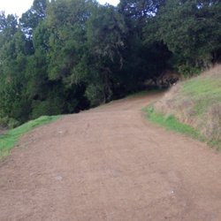
This is really an unusual Trailhead. There's an old school nearby, and you have to take the trail to the left of the school. When I came out of the open space, it wasn't clear where the trail went. The trail goes beside the old school and Childcare Center. There are two restrooms as well as a drinking fountain. I counted about four picnic tables as well. If you are on a bike the trail beside the school is skinny and steep but just for a short while. So just be careful about the other hikers. read more


More info about Deer Park Trailhead
You might also consider


Deer Park Trailhead - hiking - Updated July 2026
Best of Fairfax
People found Deer Park Trailhead by searching for…
Easy Hikes in Fairfax, California
Hiking Trails in Fairfax, California
Walking Trails in Fairfax, California
Redwood Trees in Fairfax, California
Picnic Areas in Fairfax, California
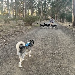
Dog Friendly Hiking Trails in Fairfax, California
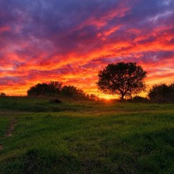
Sunrise View in Fairfax, California
Waterfall Hike in Fairfax, California
Things to Do in Fairfax, California
Scenic View in Fairfax, California
Waterfall in Fairfax, California
Running Trails in Fairfax, California
Secret Spots in Fairfax, California
Off Leash Dog Hikes in Fairfax, California
Parks for Kids in Fairfax, California
Mountain Biking in Fairfax, California
Sunrise Hike in Fairfax, California
Romantic Picnic Secluded in Fairfax, California
Fall Foliage in Fairfax, California
Wildflowers in Fairfax, California
Trending Searches in Fairfax, CA
Browse Articles
Browse Nearby
BEST of Fairfax, California Walking Trails near Deer Park Trailhead
BEST of Fairfax, California Coffee near Deer Park Trailhead
BEST of Fairfax, California Restaurants near Deer Park Trailhead
BEST of Fairfax, California Things to Do near Deer Park Trailhead
BEST of Fairfax, California Parks near Deer Park Trailhead
BEST of Fairfax, California Breakfast near Deer Park Trailhead
BEST of Fairfax, California Caves near Deer Park Trailhead
BEST of Fairfax, California Hot Springs near Deer Park Trailhead
BEST of Fairfax, California Campgrounds near Deer Park Trailhead
Browse Brands
Related Searches in Fairfax, CA
Affordable Kayak Rental Services in Fairfax, California
Best Fishing Locations and Guides in Fairfax, California
Best Nature Trails for Hiking in Fairfax, California
Best Places for Horseback Riding in Fairfax, California
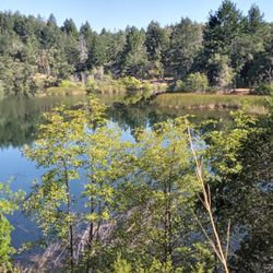
Best Waterfalls and Swimming Holes in Fairfax, California
Check Out Off Road Trails in Fairfax, California
Discover Dog Friendly Trails to Explore in Fairfax, California
Discover Kid Friendly Hiking Trails in Fairfax, California
Discover Scenic Hiking Trails in Fairfax, California
Discover Scenic Mountain Bike Trails Near Fairfax, California
Discover Scenic Waterfall Spots in Fairfax, California
Discover Walking Parks in Fairfax, California Near You
Discover a Hiking Trail in Fairfax, California
Discover the Best Night Hike Trails in Fairfax, California
Discover the Best Running Track in Fairfax, California
Dog-Friendly Hikes With Dogs in Fairfax, California
Enjoy Camping Adventures Around Fairfax, California
Enjoy Kayaking Adventures in Fairfax, California
Enjoy Tent Camping Spots Around Fairfax, California
Enjoy a Beautiful Waterfall Hike in Fairfax, California
Enjoy the Best Picnic Spots and Ideas in Fairfax, California
Enjoy the Best Walking Path in Fairfax, California
Enjoy the Best Walking Trails in Fairfax, California
Exciting Cliff Jumping Spots in Fairfax, California
Explore Beautiful Parks and Green Spaces in Fairfax, California
Explore Easy Hikes Perfect for All in Fairfax, California
Explore Fun Activities to Do in Fairfax, California
Explore Popular Campgrounds Near Fairfax, California
Explore the Best Beach Spots in Fairfax, California
Explore the Best Swimming Holes Around Fairfax, California
Explore the Best Trail Options in Fairfax, California
Family Friendly Hiking With Kids in Fairfax, California
Find Beautiful Views in Fairfax, California
Find the Best Parks for Picnics in Fairfax, California
Find the Best Scenic View Locations in Fairfax, California
Great Places to Walk in Fairfax, California
Hike the Popular Waterfall Trail in Fairfax, California
Hiking Trails With Waterfalls in Fairfax, California
Off Leash Dog Hiking Trails in Fairfax, California
Plan a Scenic Drive Route Near Fairfax, California
Popular Outdoor Activities to Try in Fairfax, California
Popular Picnic Spots to Visit in Fairfax, California
Safe River Swimming Areas in Fairfax, California
Safe and Fun Parks for Kids in Fairfax, California
Top Climbing Spots and Gyms in Fairfax, California
Top Running Trails to Explore in Fairfax, California
Top Swimming Lakes to Enjoy in Fairfax, California
Top Swimming Spots and Pools in Fairfax, California
People who viewed Deer Park Trailhead also viewed
Terra Linda Sleepy Hollow Ridge
14 reviews
Rush Creek Preserve
18 reviews
Terra Linda-Sleepy Hollow Divide Northern Preserve
10 reviews
Olompali State Historic Park
37 reviews
Indian Tree Preserve
14 reviews
Roys Redwoods Preserve
20 reviews
Natalie Coffin Greene Park
12 reviews
Fairfax Open Space Preserve
6 reviews
Ridgewood Trail
1 review
Tenderfoot Trail
2 reviews