Lake Lagunitas Photos


You might also consider
More like Lake Lagunitas
Recommended Reviews - Lake Lagunitas
Start your review...

Reviews With Photos

Such a beautiful place! Very nice and very well maintained. I went here for a hike on Black Friday to #OptOutside instead going shopping and had a great time, despite the first big storm of the season! As far as location goes, as you enter the park, you will see an automated parking ticket area to your right. There are several areas within the park that you can go to, which are labeled with signs, including Bon Tempe Lake. I chose to go to Lake Lagunitas this time. On to the hike! I parked at the Lake Lagunitas parking lot and pretty much just started walking until I saw the lake. Such beautiful scenery here! And since it was storming, I almost had the park to myself! I only encountered 3 other hikers on the 2 mile loop. I encountered several bridges on the way, and tons of puddles and mini streams due to the storm. The good thing is the trail never really got muddy, despite the heavy rains. All in all, this was a beautiful, easy hike, and I will definitely be back again when the weather is better, lol. I'll also try to add Bon Tempe to my hike next time.

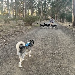
Beautiful lake at all times of day, in all types of weather. You can walk the loop for a full 2-mike hike with some rolling hills and views of the lake. Lots of birds to see here as well. On a rainy hike, I once spotted several banana slugs, newts, and even the native redwood snail! The trail is open to dogs on leash, people on horseback, cyclists, and of course hikers. People of all ages can do this easy hike. There are some spots with stairs though, as well as a couple bridge crossings, so be prepared for that. Parking is $8 per vehicle, per day.

I typically give nice nature trails five stars, but this falls a bit short for two reasons: 1) The hike is way shorter than I'm used to and 2) the entrance fee, especially given the short hike, is kind of steep. If you bring food, like we did, fuck with some good herb (I ate a double dose of something homemade, so I spent the first couple hrs starring at the waterfall and munchin'), and spend time sitting around to take it all in, I feel you'll get your money's worth. The penis tree is funny, there's water to dip your feet into, and the waterfall is pretty kickass.


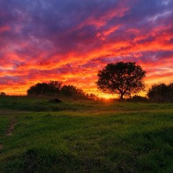
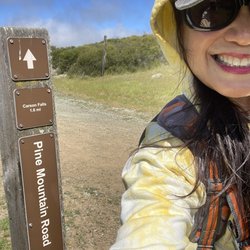
Very easy 2 mile walk that can be done in about an hour. Lake Lagunitas is good to walk around in all weather. It's beautiful in the sunshine where you can sit on a lakeside bench looking out but I also love it when it's foggy and misty around. It feels mysterious and kind of reminds me of Camp Crystal Lake in Friday the 13th. Sounds from birds and woodpeckers are abundant, it's really quiet and peaceful out here. The terrain changes from views right along the lake to redwood forest with running streams (in winter). There are many other options to add if one wants to make this hike longer. Bon Tempe Lake is next door and there are about 4 different trails that intersect the main loop. You can even hike to Mount Tam from here. It's very similar to Phoenix Lake in distance, difficulty, and the possibility of adding other trails to the loop. Personally I think it's worth the drive and worth paying the $8 to forego the parking hassle at Phoenix Lake.

Lake Lagunitas, how I love you. I discovered this beautiful lake by mistake one afternoon last spring. My friend and I were driving around Fairfax searching for a specific trail, which we never found. We must have spent hours looking before we picked up our map and discovered that Lake Lagunitas was close by. That afternoon we explored the hidden paths and ended up wandering along the trail around Bon Tempe. It was a lovely afternoon filled with sunshine, stories, and happy memories. I have only returned a few times, but each time I walk the trails around the lake I feel at peace. It's not a strenuous hike by any means, it's a just a simple walk with a few hills here and there (you can make it longer if you decide to walk to Bon Tempe, or take some trails off the beaten path.) I've brought my doggie, friends, family, and everyone enjoys it. I have to say that I really think that there's something about this lake that feels magical. Perhaps it's because I frequently visit Phoenix Lake and I need a change, but I'm not sure that's it. I'm just going to convince myself that this place is special. Take my advice and bring a picnic, camera, partner, yourself, a journal, or whatever you'd like and enjoy the scenery. Once you check out the lake for yourself, let me know if you love it as much as I do :)

It's a great place to spend the day with family i.e., hiking, fishing, picnics, running, wildlife, etc. While strolling around the lake, look for the family circle tree & take a picture (nice keepsake). Try counting how many bridges you cross & how many creeks. See if you can find a newt & hold it in your hands (bring sanitizers). The drive is scenic through the small town of Fairfax. There is an entrance fee of $7 with plenty of parking. The park ranger gave us a nice tour and lots of information.


It was absolutely Beautiful. We hiked around the lake. It was an easy hike and so fun. They have lots of picnic tables and so many trees. You have to pay for parking and it's at the station a little before you actually park I gave the lake five stars but the road to get up there two stars. It's a very skinny road and only one car can pass with two way traffic. Yikes.....But we made it and it was worth the trip! read more


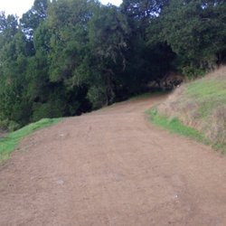
Such a cool place -- and it's one of those locations that not too many people go to unless they are in the area. Somewhat of a "locals" spot for hiking, biking, and trail running. In addition, it's also a beautiful drive up! The road eventually becomes one-lane, so drive slowly when the road bends. People like to drive a little faster than they should on it, unfortunately. The parking is ample. After you pay the entrance fee, you'll see several opportunities to park on your way down the road. The main Parking lot is all the way at the end where the bathroom and shelter/picnic area is. There's also a neat creek and man-made waterfall over here as well that comes from the reservoir up top. The hike itself is really fun. We hiked up to the top where the reservoir is and really loved the view. My Apple Watch says that our walk around the perimeter of the reservoir was roughly 2 miles. I wouldn't call it a hike, per se, but it was a nice, leisurely walk in a beautiful place which is just as nice! There are tons of redwoods, oak trees, and wild flowers here, but also poison oak. The trails seem pretty well-maintained, so there isn't much need to worry about poison oak as long as you don't wander too far off the trail. Great for kids, as there isn't much incline on this trail. I would definitely come back and try more of the trails here. read more

Well if Phoenix lake is the most beautiful lake in the world, Lagunitas Lake must be number two. I rode my mountain bike around the Three Lakes and ended up by Lake Lagunitas. There's a nice trail that goes right around the lake. Absolutely gorgeous views. The Watershed is managed by The Marin Municipal Water District. They also employ Park Rangers, who regularly go around making sure everyone is safe. I had a chance to visit with one park ranger, who was extremely helpful and conscientious. There's a large parking area with bathroom and drinking faucets. read more


Such a beautiful place! Very nice and very well maintained. I went here for a hike on Black Friday to #OptOutside instead going shopping and had a great time, despite the first big storm of the season! As far as location goes, as you enter the park, you will see an automated parking ticket area to your right. There are several areas within the park that you can go to, which are labeled with signs, including Bon Tempe Lake. I chose to go to Lake Lagunitas this time. On to the hike! I parked at the Lake Lagunitas parking lot and pretty much just started walking until I saw the lake. Such beautiful scenery here! And since it was storming, I almost had the park to myself! I only encountered 3 other hikers on the 2 mile loop. I encountered several bridges on the way, and tons of puddles and mini streams due to the storm. The good thing is the trail never really got muddy, despite the heavy rains. All in all, this was a beautiful, easy hike, and I will definitely be back again when the weather is better, lol. I'll also try to add Bon Tempe to my hike next time. read more


Beautiful lake at all times of day, in all types of weather. You can walk the loop for a full 2-mike hike with some rolling hills and views of the lake. Lots of birds to see here as well. On a rainy hike, I once spotted several banana slugs, newts, and even the native redwood snail! The trail is open to dogs on leash, people on horseback, cyclists, and of course hikers. People of all ages can do this easy hike. There are some spots with stairs though, as well as a couple bridge crossings, so be prepared for that. Parking is $8 per vehicle, per day. read more


10 years ago
I typically give nice nature trails five stars, but this falls a bit short for two reasons: 1) The hike is way shorter than I'm used to and 2) the entrance fee, especially given the short hike, is kind of steep. If you bring food, like we did, fuck with some good herb (I ate a double dose of something homemade, so I spent the first couple hrs starring at the waterfall and munchin'), and spend time sitting around to take it all in, I feel you'll get your money's worth. The penis tree is funny, there's water to dip your feet into, and the waterfall is pretty kickass. read more


5 years ago
Great hike with my family , surrounded by Redwood Trees and friendly hikers. I'd encourage taking the loop. read more

Very easy 2 mile walk that can be done in about an hour. Lake Lagunitas is good to walk around in all weather. It's beautiful in the sunshine where you can sit on a lakeside bench looking out but I also love it when it's foggy and misty around. It feels mysterious and kind of reminds me of Camp Crystal Lake in Friday the 13th. Sounds from birds and woodpeckers are abundant, it's really quiet and peaceful out here. The terrain changes from views right along the lake to redwood forest with running streams (in winter). There are many other options to add if one wants to make this hike longer. Bon Tempe Lake is next door and there are about 4 different trails that intersect the main loop. You can even hike to Mount Tam from here. It's very similar to Phoenix Lake in distance, difficulty, and the possibility of adding other trails to the loop. Personally I think it's worth the drive and worth paying the $8 to forego the parking hassle at Phoenix Lake. read more


Lake Lagunitas, how I love you. I discovered this beautiful lake by mistake one afternoon last spring. My friend and I were driving around Fairfax searching for a specific trail, which we never found. We must have spent hours looking before we picked up our map and discovered that Lake Lagunitas was close by. That afternoon we explored the hidden paths and ended up wandering along the trail around Bon Tempe. It was a lovely afternoon filled with sunshine, stories, and happy memories. I have only returned a few times, but each time I walk the trails around the lake I feel at peace. It's not a strenuous hike by any means, it's a just a simple walk with a few hills here and there (you can make it longer if you decide to walk to Bon Tempe, or take some trails off the beaten path.) I've brought my doggie, friends, family, and everyone enjoys it. I have to say that I really think that there's something about this lake that feels magical. Perhaps it's because I frequently visit Phoenix Lake and I need a change, but I'm not sure that's it. I'm just going to convince myself that this place is special. Take my advice and bring a picnic, camera, partner, yourself, a journal, or whatever you'd like and enjoy the scenery. Once you check out the lake for yourself, let me know if you love it as much as I do :) read more

15 years ago
It's a great place to spend the day with family i.e., hiking, fishing, picnics, running, wildlife, etc. While strolling around the lake, look for the family circle tree & take a picture (nice keepsake). Try counting how many bridges you cross & how many creeks. See if you can find a newt & hold it in your hands (bring sanitizers). The drive is scenic through the small town of Fairfax. There is an entrance fee of $7 with plenty of parking. The park ranger gave us a nice tour and lots of information. read more


7 years ago
This is the absolute best part of Fairfax!! We moved here only three years ago and we have loved coming here all the time!! read more


7 years ago
8 years ago
12 years ago
Nice mild hike around Lagunitas and Bon Tempe Lakes! The water is gorgeous. Too bad there's no swimming! There is an $8 park entry fee. read more


8 years ago
14 years ago
15 years ago
11 years ago
5 years ago
14 years ago
11 years ago
More info about Lake Lagunitas
Lagunitas Dam Rd
Fairfax, CA 94904
Directions
Hours
Outdoor Amenities
Ask the Community - Lake Lagunitas
Is this a lake where we can go fishing?
Yes, the fishing is great at lake Lagunitas. All the MMWD lakes allow fishing. Phoenix lake near the… Read more
Review Highlights - Lake Lagunitas
You might also consider


Lake Lagunitas - hiking - Updated July 2026
Best of Fairfax
People found Lake Lagunitas by searching for…
Swimming Lakes in Fairfax, California
Swimming Holes in Fairfax, California
Fishing Spots in Fairfax, California
Hiking Trails With Waterfalls in Fairfax, California
Trout Fishing in Fairfax, California
Fishing in Fairfax, California
Easy Hikes in Fairfax, California
Dog Swimming in Fairfax, California
Secret Spots in Fairfax, California
Picnic Spots in Fairfax, California
Beautiful Views in Fairfax, California
Scenic Drive in Fairfax, California
Dog Friendly Hikes in Fairfax, California
Scenic View in Fairfax, California
Walking Trails in Fairfax, California
Redwood Trees in Fairfax, California
Picnic Areas in Fairfax, California
Places to Take Pictures in Fairfax, California
Lake Camping in Fairfax, California
Running Trails in Fairfax, California
Parks for Kids in Fairfax, California
Trending Searches in Fairfax, CA
4th Of July Fireworks in Fairfax, CA
Black Owned Nail Salons in Fairfax, CA
Dog Friendly Trails in Fairfax, CA
Outdoor Activities in Fairfax, CA
Outdoor Basketball Courts in Fairfax, CA
Parks For Picnics in Fairfax, CA
Places To Walk Around in Fairfax, CA
Scenic Night View in Fairfax, CA
Scenic Overlook in Fairfax, CA
Scenic Restaurants in Fairfax, CA
Strawberry Picking in Fairfax, CA
Volleyball Courts in Fairfax, CA
Browse Nearby
BEST of Fairfax, California Coffee near Lake Lagunitas
BEST of Fairfax, California Restaurants near Lake Lagunitas
BEST of Fairfax, California Things to Do near Lake Lagunitas
BEST of Fairfax, California Parks near Lake Lagunitas
BEST of Fairfax, California Breakfast near Lake Lagunitas
Browse Brands
Related Searches in Fairfax, CA
Affordable Kayak Rental Services in Fairfax, California
Best Fishing Locations and Guides in Fairfax, California
Best Nature Trails for Hiking in Fairfax, California
Best Places for Horseback Riding in Fairfax, California
Best Waterfalls and Swimming Holes in Fairfax, California
Check Out Off Road Trails in Fairfax, California
Discover Dog Friendly Trails to Explore in Fairfax, California
Discover Kid Friendly Hiking Trails in Fairfax, California
Discover Lakes & Ponds to Explore in Fairfax, California
Discover Scenic Hiking Trails in Fairfax, California
Discover Scenic Mountain Bike Trails Near Fairfax, California
Discover Scenic Waterfall Spots in Fairfax, California
Discover Top Nature Parks to Visit in Fairfax, California
Discover Top State Parks to Visit in Fairfax, California
Discover Walking Parks in Fairfax, California Near You
Discover a Hiking Trail in Fairfax, California
Discover the Best Beaches in Fairfax, California
Discover the Best Fishing Lake in Fairfax, California
Discover the Best Night Hike Trails in Fairfax, California
Discover the Best Running Track in Fairfax, California
Discover the Best Tide Pools in Fairfax, California
Dog-Friendly Hikes With Dogs in Fairfax, California
Enjoy Camping Adventures Around Fairfax, California
Enjoy Kayaking Adventures in Fairfax, California
Enjoy Tent Camping Spots Around Fairfax, California
Enjoy Water Activities and Fun in Fairfax, California
Enjoy a Beautiful Waterfall Hike in Fairfax, California
Enjoy the Best Picnic Spots and Ideas in Fairfax, California
Enjoy the Best Walking Path in Fairfax, California
Enjoy the Best Walking Trails in Fairfax, California
Exciting Cliff Jumping Spots in Fairfax, California
Explore Beautiful Parks and Green Spaces in Fairfax, California
Explore Boat Rentals for Every Need in Fairfax, California
Explore Easy Hikes Perfect for All in Fairfax, California
Explore Fun Activities to Do in Fairfax, California
Explore Parks With Lakes to Visit in Fairfax, California
Explore Popular Campgrounds Near Fairfax, California
Explore Popular Picnic Areas Around Fairfax, California
Explore Popular RV Parks Around Fairfax, California
Explore Popular Scenic Views Near Fairfax, California
Explore Top Dog Parks in Fairfax, California Near You
Explore Top Marinas Near Fairfax, California
Explore Top Water Parks in Fairfax, California Today
Explore the Best Beach Spots in Fairfax, California
Explore the Best Swimming Holes Around Fairfax, California
Explore the Best Trail Options in Fairfax, California
Explore the Scenic River in Fairfax, California
Family Friendly Hiking With Kids in Fairfax, California