King Mountain Photos


You might also consider
More like King Mountain
Recommended Reviews - King Mountain
Start your review...

Reviews With Photos

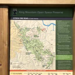
There are a few different entrances but the easiest is the access point is through Willow Road which takes you to Citron Fire Road. The fire road has a pretty good incline and there are some wild blackberry bushes along the way closer to the front. From the East side there are views of the San Rafael Bridge and East Bay. After about a mile Citron connects with King Mountain Loop Trail which is almost entirely shaded and a quiet peaceful escape from civilization. There is a bridge at one point next to a hobbit looking bench and then some stairs for more of a workout. On the west side there are views of Mount Tam. Altogether it's about 3.75 miles, not too long, not too short. King Mountain Loop Trail intersects that Lady Bug trail which takes you down to Baltimore Canyon and Dawn Falls or it also intersect Ridgecrest Road so there are some other options if you really wanted to explore and make the hike longer.
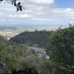
This place is a pretty good place to hike. Many sharp inclination paths so be prepared for huffing and puffing as you go up but for me is great workout. You get to see the over view site of Corte Madera and Kentfield. I walked half way returning because of an appointment but greeting two others with one already exhausted. So be ready when you decide to hike this trail. The inclinations are steep.

Highly recommend King Mountain for the best hiking trails! It could be a bit steep in some places but overall it's not super challenging, you will definitely get a great workout that will be rewarded with the best views. You can bring your puppies to walk through the fairytale woods. It's never too crowded so it's very peaceful and will 100% help you to recharge! You can plan your hike to include downtown Larkspur. This way you can enjoy pre or post work out coffee/lunch/drink, etc. Overall, it's a must if you love peaceful breathtaking hikes! read more


3 years ago
There are a few different entrances but the easiest is the access point is through Willow Road which takes you to Citron Fire Road. The fire road has a pretty good incline and there are some wild blackberry bushes along the way closer to the front. From the East side there are views of the San Rafael Bridge and East Bay. After about a mile Citron connects with King Mountain Loop Trail which is almost entirely shaded and a quiet peaceful escape from civilization. There is a bridge at one point next to a hobbit looking bench and then some stairs for more of a workout. On the west side there are views of Mount Tam. Altogether it's about 3.75 miles, not too long, not too short. King Mountain Loop Trail intersects that Lady Bug trail which takes you down to Baltimore Canyon and Dawn Falls or it also intersect Ridgecrest Road so there are some other options if you really wanted to explore and make the hike longer. read more


This place is a pretty good place to hike. Many sharp inclination paths so be prepared for huffing and puffing as you go up but for me is great workout. You get to see the over view site of Corte Madera and Kentfield. I walked half way returning because of an appointment but greeting two others with one already exhausted. So be ready when you decide to hike this trail. The inclinations are steep. read more


17 years ago
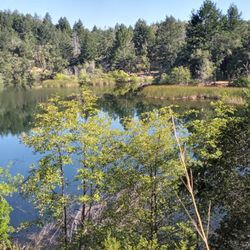
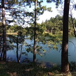
King mountain is a great little hike in Marin County. Tucked away in a residential area, you'd be hard pressed to find it unless you know exactly where to look. At just over 3 miles this hike sounds really easy, but there are many steep sections to climb and can be challenging for the beginner. Dogs are allowed on the trail but must be kept on leash(they do give out tickets for this so be careful). The views are astounding with good looks at surrounding Marin, Mt. Tam, Richmond-San Rafael bridge, and on a really clear day the East Bay shoreline looks amazing in the distance. Naturists will love this spot with all it's wildlife potential: mushroom hunting, bird watching, and the occasional bobcat or coyote. Small waterfalls cut through the main loop in a couple spots during the rainy season. Bottom Line: This hike is a must for locals looking for a quick hike/dog walk/trail run. However, if you're coming from SF or East Bay, you'll probably get more out of hiking at Mt. Tam or Point Reyes. read more


15 years ago
13 years ago
More info about King Mountain
Willow Ave
Larkspur, CA 94939
Directions
Hours
Indoor Amenities
Outdoor Amenities
Ask the Community - King Mountain
You might also consider


King Mountain - hiking - Updated June 2026
Best of Larkspur
People found King Mountain by searching for…
Hiking Trails in Larkspur, California
Walking Trails in Larkspur, California
Things to Do in Larkspur, California
Waterfall Hike in Larkspur, California
Dog Friendly Hiking Trails in Larkspur, California
Easy Hikes in Larkspur, California
Stairs Workout in Larkspur, California
Running Trails in Larkspur, California
Scenic View in Larkspur, California
Sunrise View in Larkspur, California
Dog Friendly Things to Do in Larkspur, California
Waterfall in Larkspur, California
Shaded Hike in Larkspur, California
Hikes With Dogs in Larkspur, California
Beautiful Views in Larkspur, California
Running Stairs in Larkspur, California
Playground in Larkspur, California
Off Leash Dog Hiking Trails in Larkspur, California
Hiking With Kids in Larkspur, California
Sunrise Hike in Larkspur, California
Trending Searches in Larkspur, CA
Black Owned Nail Salons near King Mountain
Boat Rental near King Mountain
Cliff Jumping near King Mountain
Fishing Spots near King Mountain
Free Kids Activities near King Mountain
Jet Ski Rental near King Mountain
Lakes & Ponds near King Mountain
Off Road Trails near King Mountain
Outdoor Activities near King Mountain
Pick Your Own Farms near King Mountain
Places To Walk Around near King Mountain
Public Shower near King Mountain
Rock Quarry near King Mountain
Scenic Drive near King Mountain
Scenic Night View near King Mountain
Secluded Spots near King Mountain
Soccer Store near King Mountain
Strawberry Picking near King Mountain
Sunrise View near King Mountain
Swimming Holes near King Mountain
Swimming Lakes near King Mountain
Swimming Pools near King Mountain
Watch Sunset near King Mountain
Browse Articles
Browse Nearby
BEST of Larkspur, California Walking Trails near King Mountain
BEST of Larkspur, California Restaurants near King Mountain
BEST of Larkspur, California Coffee near King Mountain
BEST of Larkspur, California Things to Do near King Mountain
BEST of Larkspur, California Parks near King Mountain
BEST of Larkspur, California Breakfast near King Mountain
BEST of Larkspur, California Hot Springs near King Mountain
Browse Brands
Related Searches in Larkspur, CA
Affordable Kayak Rental Services in Larkspur, California
Best Fishing Locations and Guides in Larkspur, California
Best Nature Trails for Hiking in Larkspur, California
Best Places for Horseback Riding in Larkspur, California
Check Out Off Road Trails in Larkspur, California
Discover Dog Friendly Trails to Explore in Larkspur, California
Discover Kid Friendly Hiking Trails in Larkspur, California
Discover Scenic Hiking Trails in Larkspur, California
Discover Scenic Mountain Bike Trails Near Larkspur, California
Discover Scenic Waterfall Spots in Larkspur, California
Discover Walking Parks in Larkspur, California Near You
Discover a Hiking Trail in Larkspur, California
Discover the Best Night Hike Trails in Larkspur, California
Dog-Friendly Hikes With Dogs in Larkspur, California
Enjoy Camping Adventures Around Larkspur, California
Enjoy Kayaking Adventures in Larkspur, California
Enjoy Tent Camping Spots Around Larkspur, California
Enjoy a Beautiful Waterfall Hike in Larkspur, California
Enjoy a Peaceful Nature Walk in Larkspur, California
Enjoy the Best Picnic Spots and Ideas in Larkspur, California
Enjoy the Best Walking Path in Larkspur, California
Enjoy the Best Walking Trails in Larkspur, California
Exciting Cliff Jumping Spots in Larkspur, California
Explore Beautiful Parks and Green Spaces in Larkspur, California
Explore Easy Hikes Perfect for All in Larkspur, California
Explore Fun Activities to Do in Larkspur, California
Explore Popular Campgrounds Near Larkspur, California
Explore the Best Beach Spots in Larkspur, California
Explore the Best Swimming Holes Around Larkspur, California
Explore the Best Trail Options in Larkspur, California
Family Friendly Hiking With Kids in Larkspur, California
Find Beautiful Views in Larkspur, California
Find the Best Parks for Picnics in Larkspur, California
Find the Best Scenic View Locations in Larkspur, California
Great Places to Walk in Larkspur, California
Hike the Popular Waterfall Trail in Larkspur, California
Hiking Trails With Waterfalls in Larkspur, California
Off Leash Dog Hiking Trails in Larkspur, California
Plan a Scenic Drive Route Near Larkspur, California
Popular Outdoor Activities to Try in Larkspur, California
Popular Picnic Spots to Visit in Larkspur, California
Safe River Swimming Areas in Larkspur, California
Safe and Fun Parks for Kids in Larkspur, California
Top Climbing Spots and Gyms in Larkspur, California
Top Paddleboarding Activities in Larkspur, California
Top Running Trails to Explore in Larkspur, California
Top Swimming Lakes to Enjoy in Larkspur, California
Top Swimming Spots and Pools in Larkspur, California