Carson Falls Photos


You might also consider
More like Carson Falls
Recommended Reviews - Carson Falls
Start your review...

Reviews With Photos

Round trip about 3 miles/2 hours. Park at Azalea Hill and start at the Pine Mountain Trail. If the area is full there is some parking along Bolinas road. The first part of the hike isn't that impressive trail wise. Depending on the time of the year it can be dry and dusty or very muddy. It's also rocky so I would recommend hiking boots or sturdy sneakers (no keds or flip flops). The views are vast, you can see all the way to the bay and Mt. Diablo in the distance. At about a mile take a left on Oak Road. From there go down until you hit Carson Falls Trail and make a right. This trail is better because it's more shady and forresty. Once you get to the waterfall you can view it at the top but there is also a couple of other viewing areas past the bridge down the trail. I like this waterfall because there are many different levels and it has great photo opportunities. It's also quite the social scene on weekends which make it fun yet can get a bit crowded while trying to take photos. For the serious photographer come super early or on a weekday.

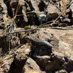
3 mile round-trip hike from Azalea Hill parking lot and back. This is Watershed land managed by Marin Water which means dogs are allowed on leash. Bikes are not allowed on trails, only the fire roads. Waterfalls are glorious. They are home to Foothill Yellow-Legged Frogs which is listed as both a federal and state species of special concern. The frogs breed in spring so it is important to keep out of the water from March through May or you might crush frogs eggs or tadpoles. Frogs, eggs and tadpoles are same greenish/gray color as the rocks so they blend in but if you have patience and/or binoculars you can spot them. You may also see newts, salamaders, lizards, all kids of wildflowers and lots of poison oak. Keep your feet and your dogs out of the falls to protect these sensitive species!

Unlike most waterfall hikes, this one is not covered. From Fairfax-Bolinas Road at Pine Mountain Road. There are about 8-10 parking spots on the left hand side of the road while the trail starts on the right hand side of the road. The first 1/2 half of this hike is mostly uphill and will catch you a little off-guard and leave you breathing a little harder than expected. There are 3 tiers of waterfalls at the top and 1tier of falls at the bottom (the biggest of the 4 which is about 35 feet). Collectively, the 4 falls are about 80 feet and if you position yourself correctly, you can capture all 4 in one shot. This hike is just over 3 miles round trip but with the elevation change during the first leg of the trail, you'll feel like you've been hiking a bit longer. =============== For more hiking recommendations: http://www.yelp.com/list_details?list_id=kc_cpimm3r3OA07lrBGKBA

It's only 1.3 in, really. Depending what you do it is about 3 miles back and forth with a decent net gain - it's a short hike that will make you feel like you worked hard if you go at a click. http://www.bahiker.com/northbayhikes/carsonfalls.html That is solid advice, except the right onto broadway doesn't mention it's actually a right from Pastorini to Belmont which becomes Central which becomes Broadway. Here's a public album of snow capped peaks on a brisk late winter Sunday. It's the time the falls are really flowing. Don't be fooled either, there's endless hiking and loops up here that go for days. You can hike to the falls, or you can also hike around the falls up the falls down the falls my oh my what a good day. pics: http://www.facebook.com/album.php?aid=111894&id=1211590808&l=f7194cb3f7

We took the Azalea Hills route and what was supposed to be about 5 miles turned into 8 miles because my friend led us off trail and lost. The shaded areas are super pretty with the giant redwoods and makes a pleasant hike. Once you're out in the sun though, its dry and rocky...reminded me of Mission Peak in Fremont. Expect it to be all uphill in the start but after that it's not that bad at all. Unfortunately, the falls had no water when we went so it was just a giant rock with some leftover moldy looking water at the bottom. No falls at Carson Falls for us =( but it was still a decent hike.

4 falls totaling about 80 feet high. Short hike less than 2 miles each way. The incline can be a bit strenuous for older folks so just walk slowly. As with all falls it is best viewed after a good rainfall. Nice quiet place usually not crowded at all on weekdays. Great place for photography, post card views. Excellent for picnics too. To get there from US 101 in Marin County, exit San Anselmo/Sir Francis Drake. Drive about 5 miles west on Sir Francis Drake to Fairfax. Turn left on Pastori, right on Broadway, and left onto Fairfax-Bolinas Road. Drive about 4 miles on Fairfax-Bolinas Road to the parking lot on the left side of the road has about 10 parking spaces. The whole Carson Creek area is a really nice place to explore.


2 months ago
Carson Falls are epic! Carson Falls drops about 80 feet along Carson Creek. In the winter after storms: totally amazing! The creek swells and the falls roar. You don't just see it, you feel it in your mind and heart! I love the power of water falls! In the summer, the water falls are quiet, delicate, still stunning. Your peaceful serenity moment with zero crowds makes your heart melt with smiles. Bring your lunch. Or a book. Or just simply enjoy the magic of living! It's about 3 miles round trip. 2 hours. Steady but happy climb, totally doable! The kind of "easy enough for any day of the week, rewarding enough to brag about hike. Chase this one right after a huge storm must be spectacular! Trust me. You'll see why Marin locals try to keep it quiet. Who's adding this to their hiking list? read more


This is a case where the journey is more important than the destination. Carson Falls is located in a remote part of Marin County. When I was into mountain biking, I read a book about the biking trails in Marin. On a scale of 1 to 5, 5 being the toughest, the Pine Mountain area is a 6! Pine Mountain Road is not only remote, it's rocky. If you get in trouble out here, you're REALLY in trouble. I'll stick to hiking, thankyouverymush. First stop: Carson Falls. I went in March, there had already been a few showers that year, so I wasn't worried about the lack of water. I was spectacularly underwhelmed. I think the falls are around 25 feet tall, and it wouldn't take much for the creek to run out of water. The rock where you can gaze at the falls while eating lunch is nice, and the immediate area is home to an endangered yellow-legged frog. Oh well, so much for this destination. The journey - the acreage surrounding the falls - truly is spectacular. Especially in Spring, when the grass is still green. Forests alternating with low manzanita. The last quarter mile before Carson Falls is deep redwoods. Views of canyons, ridgelines, the Meadow Club Golf Course, both Alpine and Kent Lakes, and Marin suburbia in the distance. You can even see Mt. Diablo and Mt. Tam in the same shot. I made it up to Pine Mountain, which requires bushwhacking to get to the actual summit, and found two mysterious rockwalls hidden among the manzanita. If camping was allowed here, there are plenty of nice backpacking spots, but this is an area for storage of Marin drinking water so camping is out. The Carson Falls and Pine Mountain area is really nice if you're looking for a different outdoors jaunt. It's not undiscovered by any means, but it does offer an experience that's different from most in Marin County - or the entire Bay Area, for that matter. read more


In August, the Falls don't have much water! I did not have super high hopes, since I figured in August the Falls would not be running so well. Guess what? They weren't running at all! Hike up Carson Falls Trail was a bit steep in places. So be sure to wear good hiking shoes. Even though the Falls were not running today, I could still appreciate the wonderful location. Plus, it's a nice hike up there anyway. read more


Round trip about 3 miles/2 hours. Park at Azalea Hill and start at the Pine Mountain Trail. If the area is full there is some parking along Bolinas road. The first part of the hike isn't that impressive trail wise. Depending on the time of the year it can be dry and dusty or very muddy. It's also rocky so I would recommend hiking boots or sturdy sneakers (no keds or flip flops). The views are vast, you can see all the way to the bay and Mt. Diablo in the distance. At about a mile take a left on Oak Road. From there go down until you hit Carson Falls Trail and make a right. This trail is better because it's more shady and forresty. Once you get to the waterfall you can view it at the top but there is also a couple of other viewing areas past the bridge down the trail. I like this waterfall because there are many different levels and it has great photo opportunities. It's also quite the social scene on weekends which make it fun yet can get a bit crowded while trying to take photos. For the serious photographer come super early or on a weekday. read more

5 years ago
3 mile round-trip hike from Azalea Hill parking lot and back. This is Watershed land managed by Marin Water which means dogs are allowed on leash. Bikes are not allowed on trails, only the fire roads. Waterfalls are glorious. They are home to Foothill Yellow-Legged Frogs which is listed as both a federal and state species of special concern. The frogs breed in spring so it is important to keep out of the water from March through May or you might crush frogs eggs or tadpoles. Frogs, eggs and tadpoles are same greenish/gray color as the rocks so they blend in but if you have patience and/or binoculars you can spot them. You may also see newts, salamaders, lizards, all kids of wildflowers and lots of poison oak. Keep your feet and your dogs out of the falls to protect these sensitive species! read more

Unlike most waterfall hikes, this one is not covered. From Fairfax-Bolinas Road at Pine Mountain Road. There are about 8-10 parking spots on the left hand side of the road while the trail starts on the right hand side of the road. The first 1/2 half of this hike is mostly uphill and will catch you a little off-guard and leave you breathing a little harder than expected. There are 3 tiers of waterfalls at the top and 1tier of falls at the bottom (the biggest of the 4 which is about 35 feet). Collectively, the 4 falls are about 80 feet and if you position yourself correctly, you can capture all 4 in one shot. This hike is just over 3 miles round trip but with the elevation change during the first leg of the trail, you'll feel like you've been hiking a bit longer. =============== For more hiking recommendations: http://www.yelp.com/list_details?list_id=kc_cpimm3r3OA07lrBGKBA read more


15 years ago
It's only 1.3 in, really. Depending what you do it is about 3 miles back and forth with a decent net gain - it's a short hike that will make you feel like you worked hard if you go at a click. http://www.bahiker.com/northbayhikes/carsonfalls.html That is solid advice, except the right onto broadway doesn't mention it's actually a right from Pastorini to Belmont which becomes Central which becomes Broadway. Here's a public album of snow capped peaks on a brisk late winter Sunday. It's the time the falls are really flowing. Don't be fooled either, there's endless hiking and loops up here that go for days. You can hike to the falls, or you can also hike around the falls up the falls down the falls my oh my what a good day. pics: http://www.facebook.com/album.php?aid=111894&id=1211590808&l=f7194cb3f7 read more


5 years ago
9 years ago
We took the Azalea Hills route and what was supposed to be about 5 miles turned into 8 miles because my friend led us off trail and lost. The shaded areas are super pretty with the giant redwoods and makes a pleasant hike. Once you're out in the sun though, its dry and rocky...reminded me of Mission Peak in Fremont. Expect it to be all uphill in the start but after that it's not that bad at all. Unfortunately, the falls had no water when we went so it was just a giant rock with some leftover moldy looking water at the bottom. No falls at Carson Falls for us =( but it was still a decent hike. read more


12 years ago
4 falls totaling about 80 feet high. Short hike less than 2 miles each way. The incline can be a bit strenuous for older folks so just walk slowly. As with all falls it is best viewed after a good rainfall. Nice quiet place usually not crowded at all on weekdays. Great place for photography, post card views. Excellent for picnics too. To get there from US 101 in Marin County, exit San Anselmo/Sir Francis Drake. Drive about 5 miles west on Sir Francis Drake to Fairfax. Turn left on Pastori, right on Broadway, and left onto Fairfax-Bolinas Road. Drive about 4 miles on Fairfax-Bolinas Road to the parking lot on the left side of the road has about 10 parking spaces. The whole Carson Creek area is a really nice place to explore. read more

9 years ago
16 years ago
9 years ago
Good number of options of hikes to choose from in this area. Dog friendly trails. Biking and walking both. A bit challenging on a sunny day as there is a lot of open trails and are also quite steep in some areas. Be on a look out for snakes though! read more

11 years ago
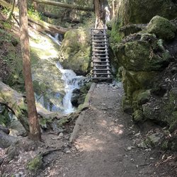
Beautiful hike with a lot of trails to choose from. Bring your dog, great dog-friendly hike! We got there late- around 10:30 on a weekend and there was surprisingly a lot of parking available in the dirt across the street from the trail head. The trail to the falls is less than 2 miles, but you have to hike up a pretty steep incline initially with no shade. It gives you great views of the bay, Mt.Tam, and the lake though! After you get up the steep part you head down to view the falls by taking Oat Hill Road to the left. Then take Little Carson Trail to the right. We went late January and there wasn't a lot of water, but it was bigger than expected, so still nice. When you reach a bridge, head to the left and you can view the upper falls. Then cross the bridge and head down the stairs to get a view of the lower part. You can go down to the pools at the base of the falls. The trail continues all the way down to the lake- it's mostly shaded and follows a stream, so it's very scenic but long and a steep hike back. The hike back up from the falls is pretty steep but definitely worth it. There was a huge tour group behind us for most of the hike, which made it less enjoyable. I hope that's not a regular thing. Would love to go back super early when it's fully flowing. We got back around 3pm and there was zero parking available, so go early! read more


9 years ago
15 years ago
9 years ago
9 years ago
9 years ago
12 years ago
9 years ago
15 years ago
13 years ago
More info about Carson Falls
Fairfax Bolinas Rd
Bolinas, CA 94930
Directions
Visit Website
http://www.waterfallswest.com/ca_carson.html
Hours
Indoor Amenities
Outdoor Amenities
Ask the Community - Carson Falls
Review Highlights - Carson Falls
You might also consider


Why does Yelp recommend reviews?
1 review that is not currently recommended
The reviews below are not factored into the business's overall star rating.
10 years ago
Carson Falls - hiking - Updated June 2026
Best of Bolinas
People found Carson Falls by searching for…
Hiking Trails With Waterfalls in Bolinas, California
Hot Springs in Bolinas, California
Dog Friendly Hiking Trails in Bolinas, California
Campgrounds in Bolinas, California
Redwood Trees in Bolinas, California
Things to Do in Bolinas, California
Easy Hikes in Bolinas, California
Waterfalls in Bolinas, California
Mountain Bike Trails in Bolinas, California
Beautiful Views in Bolinas, California
Public Shower in Bolinas, California
Scenic Drive in Bolinas, California
Walking Trails in Bolinas, California
Redwood Forest in Bolinas, California
Dog Friendly Parks in Bolinas, California
Hiking Club in Bolinas, California
Stairs Workout in Bolinas, California
Scenic View in Bolinas, California
Places to Take Pictures in Bolinas, California
Secret Spots in Bolinas, California
Off Leash Dog Hiking Trails in Bolinas, California
Trending Searches in Bolinas, CA
Black Owned Nail Salons near Carson Falls
Cliff Jumping near Carson Falls
Fishing Spots near Carson Falls
Free Kids Activities near Carson Falls
Jet Ski Rental near Carson Falls
Lakes & Ponds near Carson Falls
Off Road Trails near Carson Falls
Outdoor Activities near Carson Falls
Pick Your Own Farms near Carson Falls
Places To Walk Around near Carson Falls
Public Shower near Carson Falls
Scenic Drive near Carson Falls
Scenic Night View near Carson Falls
Secluded Spots near Carson Falls
Soccer Store near Carson Falls
Strawberry Picking near Carson Falls
Sunrise View near Carson Falls
Swimming Holes near Carson Falls
Swimming Lakes near Carson Falls
Swimming Pools near Carson Falls
Browse Articles
Browse Nearby
BEST of Bolinas, California Coffee near Carson Falls
BEST of Bolinas, California Restaurants near Carson Falls
BEST of Bolinas, California Things to Do near Carson Falls
BEST of Bolinas, California Parks near Carson Falls
BEST of Bolinas, California Breakfast near Carson Falls
BEST of Bolinas, California Swimming Holes near Carson Falls
Browse Brands
Related Searches in Bolinas, CA
Affordable Kayak Rental Services in Bolinas, California
Best Fishing Locations and Guides in Bolinas, California
Best Nature Trails for Hiking in Bolinas, California
Best Places for Horseback Riding in Bolinas, California
Best Waterfalls and Swimming Holes in Bolinas, California
Check Out Off Road Trails in Bolinas, California
Discover Dog Friendly Trails to Explore in Bolinas, California
Discover Scenic Hiking Trails in Bolinas, California
Discover Scenic Mountain Bike Trails Near Bolinas, California
Discover Scenic Waterfall Spots in Bolinas, California
Discover Top Nature Parks to Visit in Bolinas, California
Discover a Hiking Trail in Bolinas, California
Discover the Best Night Hike Trails in Bolinas, California
Dog-Friendly Hikes With Dogs in Bolinas, California
Enjoy Camping Adventures Around Bolinas, California
Enjoy Kayaking Adventures in Bolinas, California
Enjoy Tent Camping Spots Around Bolinas, California
Enjoy a Beautiful Waterfall Hike in Bolinas, California
Enjoy the Best Picnic Spots and Ideas in Bolinas, California
Enjoy the Best Walking Trails in Bolinas, California
Exciting Cliff Jumping Spots in Bolinas, California
Explore Beautiful Parks and Green Spaces in Bolinas, California
Explore Easy Hikes Perfect for All in Bolinas, California
Explore Fun Activities to Do in Bolinas, California
Explore Popular Campgrounds Near Bolinas, California
Explore the Best Beach Spots in Bolinas, California
Explore the Best Swimming Holes Around Bolinas, California
Explore the Best Trail Options in Bolinas, California
Family Friendly Hiking With Kids in Bolinas, California
Find Beautiful Views in Bolinas, California
Find Popular Ziplining Spots Around Bolinas, California
Find the Best Parks for Picnics in Bolinas, California
Find the Best Scenic View Locations in Bolinas, California
Great Places to Walk in Bolinas, California
Hiking Trails With Waterfalls in Bolinas, California
Off Leash Dog Hiking Trails in Bolinas, California
Plan a Scenic Drive Route Near Bolinas, California
Popular Outdoor Activities to Try in Bolinas, California
Popular Picnic Spots to Visit in Bolinas, California
Safe River Swimming Areas in Bolinas, California
Safe and Fun Parks for Kids in Bolinas, California
Top Climbing Spots and Gyms in Bolinas, California
Top Paddleboarding Activities in Bolinas, California
Top Places for Snorkeling in Bolinas, California
Top Playgrounds for Kids to Enjoy in Bolinas, California
Top Running Trails to Explore in Bolinas, California
Top Swimming Lakes to Enjoy in Bolinas, California
Top Swimming Spots and Pools in Bolinas, California
People who viewed Carson Falls also viewed
Tomales Point Trail - Tule Elk Preserve
136 reviews
Fairfax Open Space Preserve
6 reviews
Tennessee Valley
203 reviews
Dawn Falls
48 reviews
Presidio Promenade Trail
5 reviews
Presidio
Dipsea
92 reviews
Blithedale Summit Open Space Preserve
8 reviews
Steep Ravine Trail
48 reviews
Golden Gate Promenade
3 reviews
Presidio
Immigrant Point/Coastal Connector Trail aka 1,000 Step Trail
10 reviews
Presidio