Matt Davis Trail Photos


You might also consider
More like Matt Davis Trail
Recommended Reviews - Matt Davis Trail
Start your review...

Reviews With Photos

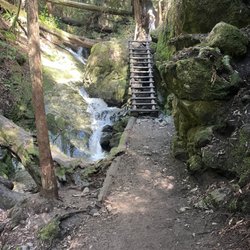
A killer workout if you're starting from Stinson Beach!!! It's all uphill but totally worth it for the views through the Steep Ravine. Hiked this trail in conjunction with the Steep Ravine and Dipsea Trails and looped back to Stinson Beach. The entire hike was magical, but this part of the hike was definitely the most difficult part. If you're starting from Stinson Beach, it's a 3.6 mile uphill hike to Pantoll Campground. The trailhead can be a little tough to find, but it's right behind the fire station. The trail starts off gradually inclining through the forest. You'll soon begin switchbacking up stairs and over several cross bridges. You'll pass through beautiful redwood groves and fern filled meadows. This part of the trail is very green and also completely shaded. At roughly 2 miles in, you'll reach a point where the trail switches from shaded to exposed. You'll get a few peek-a-boo coastal views here. The trail continues along a narrow ridge up to Pantoll Campground. I'm sure this part of the trail is green in the spring, but if you're coming during the summer, expect those golden hillsides. Once you reach the top, it'll take you out to the road. You'll have to cross the street to continue on the trails. From here, you can connect to several other different trails within Mount Tamalpais, and you can even go all the way into Muir Woods. The most popular loop trail is through the Steep Ravine Trail. I would highly recommend the loop to Steep Ravine and Dipsea. I honestly feel like going back down through the Steep Ravine Trail is what makes the uphill climb through the Matt Davis Trail completely worth it. Make sure you bring lots of water and sunscreen. Also, start early if you want to avoid the crowds and park at the beach so that you can relax there afterward and not have to fight for afternoon parking. Would definitely hike this trail again as a loop to Steep Ravine.


We did a roughly 7 mile circuit of Dipsea/Steep Ravine/Matt Davis, starting and ending in Stinson Beach. Moderately challenging hike with very varied scenery along the way so never a boring moment. Compared to east coast trails most of the trail surface's quite even and not very rocky. At about 2/3 of the way we stopped on a hilltop to rest and have lunch - good spot for a view of the San Francisco skyline. Closer to the end there was another smaller lookout for a view of the town of Stinson Beach. All the trails are well maintained and marked and there are longer and shorter variations suitable for all levels and abilities.

We parked at the Stinson Beach Parking lot and walked pass the firehouse to the Matt Davis Trail. It was about 4 miles round trip for us. It's a moderate hike, definitely need good hiking shoes. There are a lot of stairs and rocks you have to climb up. There are little streams you have to cross. Be careful of poison ivy on the way. The Matt Davis trail continues up a couple of hills but we stopped at the first flat area we came across and headed back to enjoy Stinson beach. Definitely bring enough water and snacks and enjoy them at the top! Happy Hiking!

Another review of a place from my childhood, that I was able to revisit recently when I was out visiting my family. We were out here for a particular purpose (spreading my dad's ashes) and the Matt Davis Trail is the way to get to the particular place he wanted to end up. Anyway. The trail hasn't really changed much since I was a kid - I'm sure some of the stairs and bridges have been replaced at some point, but then again, perhaps they're the same ones. I think that perhaps the biggest difference is that the trail is more eroded than I remember it, but there's probably at least 3-4 times the traffic that was on it when I was young. During our hike that day, there was not a moment that we were really alone, so if you want a solitary hike, this isn't necessarily a hike that will give you that, unless it's perhaps in the middle of the week during the off season. It's also part of a loop that includes the Steep Ravine and Dipsea trails, so that makes it even more popular. The views are spectacular overall, and although crowded, it's still a great hike.

What a gorgeous hike! It can be cloudy up here so be sure to go on a clear day. If you google Matt Davis Trail you'll probably find this www.bahiker.com/northbayhikes/stinson.html and this guy's info is on the dot! I ended up taking a more scenic route to the hike trailhead by not going on Panaromic Highway but instead continuing on 1 (aka Shoreline Highway in this area) and then taking a right onto Belvedere St. This allows you to see the ocean view vista points along the way (and the traffic is lighter too ;) ;) ) If you go on a clear day in fall, spring, summer, be sure to bring a sports bra as you will be stripping. It gets nice and warm and humid up in the hills and the trail starts out all uphill for 2.2 miles! **Note** once you're at the top you will reach a sign (I added photo) TAKE THIS ROUTE TO THE COSTAL TRAIL. Just go down the costal trail for a few minutes and you'll see the view you hiked all the way up for. For dinner, I highly recommend Sand Dollar. Their wine service, ambiance, and food were perfect. They also let us split entrees. They had a live musician too.

The Matt Davis Trail rocks! It's only 3.3 miles to or from Stinson Beach. It's gorgeous, and the changes in scenery make it even better. You start in the forest and the next thing you know, you're in the most gorgeous meadow where you literally feel like you're walking through the clouds. The highest elevation is about 1500 feet, which makes for some awesome ocean views. Even going uphill, it's fun. There are lots of stairs. Don't miss the lookout rock...just don't try to catch Pokemon up there because it could lead to disaster!!

Beautiful place to go for a nice Hike. The views amazing and the beach A lot of different trails to take. Taking trails uphill goodluck if you are not really into shape. One trail up back to the visitor center where we parked kicked my butt. Nothing but stair and uphill steeps for 30min wooooo what a workout.

This trail is lush trail with lots of greenery, ferns, and streams in the winter. It's canopied for most of the trail but there are some clearings with views of Stinson. I think it's easiest to park at the Pantoll campground. It's about 4 miles to Stinson Beach from here. This hike can be done as an out and back or a loop with the Steep Ravine Trail. read more


1 year ago
I just hiked this whole trail yesterday, and it was pretty hard. The first mile uphill from the Stinson Beach Fire Station was killer. Have you ever just wanted to walk up steep, slippery stairs for a mile straight? If so, this may be the hike for you. That being said, the scenery is unreal. The redwoods are covered in so many deep, thick layers of lichen and mosses, it's like a mini forest on each tree. The canyons, which can be hundreds of feet high, are filled to the brims with ferns, buckeye, and rhododendron. Many of the underlying rocks are serpentine. Mini waterfalls dripping through moss over serpentine looks like something out of a fairy tail. Imagine you're staring at one, and a red fox trots up. I've had a few of these follow me, especially at dusk. I've never heard of one attacking a human, but they can be annoying and kind of hard to scare off. Some other animals I've seen on this trail over the years include deer, coyotes, rabbits, squirrels, and all kinds of birds. I also saw a few white butterflies with gold streaks on their wings. The flowers are too numerous to name in a review, but some of my favorites that I saw this time were the Calypso orchids, poppies, lupine, irises, lilies, shooting stars, blooming grasses and miners lettuce, and more. By the time I finished hiking this trail, I could barely walk. Mission accomplished, I guess. The signs are pretty easy to follow, and I had an easy time figuring out how to make a loop from Pantoll to Stinson Beach and back. There was no water anywhere on the trail, and the closest food stores are the convenience stores and restaurants in Stinson Beach. One of the hardest but also most beautiful hikes I've done. The whole trail is just over four miles long, but took me nearly two hours to complete since I was going uphill and had done Steep Ravine first. read more


Me and my friend started this trail near the Pantoll Ranger Station. In the beginning it was easy going and not too difficult. Getting closer towards Stinson Beach was very steep. I could already feel that going back would be the toughest part of the hike. I'm so glad we started the way we did though because there's restaurants nearby when we reached Stinson beach and I was getting really hungry since I didn't eat in the morning. A moderate hike. Took me and my friend about 5 hours to complete 8 miles. read more


A killer workout if you're starting from Stinson Beach!!! It's all uphill but totally worth it for the views through the Steep Ravine. Hiked this trail in conjunction with the Steep Ravine and Dipsea Trails and looped back to Stinson Beach. The entire hike was magical, but this part of the hike was definitely the most difficult part. If you're starting from Stinson Beach, it's a 3.6 mile uphill hike to Pantoll Campground. The trailhead can be a little tough to find, but it's right behind the fire station. The trail starts off gradually inclining through the forest. You'll soon begin switchbacking up stairs and over several cross bridges. You'll pass through beautiful redwood groves and fern filled meadows. This part of the trail is very green and also completely shaded. At roughly 2 miles in, you'll reach a point where the trail switches from shaded to exposed. You'll get a few peek-a-boo coastal views here. The trail continues along a narrow ridge up to Pantoll Campground. I'm sure this part of the trail is green in the spring, but if you're coming during the summer, expect those golden hillsides. Once you reach the top, it'll take you out to the road. You'll have to cross the street to continue on the trails. From here, you can connect to several other different trails within Mount Tamalpais, and you can even go all the way into Muir Woods. The most popular loop trail is through the Steep Ravine Trail. I would highly recommend the loop to Steep Ravine and Dipsea. I honestly feel like going back down through the Steep Ravine Trail is what makes the uphill climb through the Matt Davis Trail completely worth it. Make sure you bring lots of water and sunscreen. Also, start early if you want to avoid the crowds and park at the beach so that you can relax there afterward and not have to fight for afternoon parking. Would definitely hike this trail again as a loop to Steep Ravine. read more


4 years ago
Gorgeous hike with many options. We took the bus up from the beach area and walked down (3.5 ish hours). The bottom of this trail leads right to the little shops along Stinson beach, grab a drink or snack and walk on the beach it's gorgeous! read more


We did a roughly 7 mile circuit of Dipsea/Steep Ravine/Matt Davis, starting and ending in Stinson Beach. Moderately challenging hike with very varied scenery along the way so never a boring moment. Compared to east coast trails most of the trail surface's quite even and not very rocky. At about 2/3 of the way we stopped on a hilltop to rest and have lunch - good spot for a view of the San Francisco skyline. Closer to the end there was another smaller lookout for a view of the town of Stinson Beach. All the trails are well maintained and marked and there are longer and shorter variations suitable for all levels and abilities. read more


7 years ago
We parked at the Stinson Beach Parking lot and walked pass the firehouse to the Matt Davis Trail. It was about 4 miles round trip for us. It's a moderate hike, definitely need good hiking shoes. There are a lot of stairs and rocks you have to climb up. There are little streams you have to cross. Be careful of poison ivy on the way. The Matt Davis trail continues up a couple of hills but we stopped at the first flat area we came across and headed back to enjoy Stinson beach. Definitely bring enough water and snacks and enjoy them at the top! Happy Hiking! read more


8 years ago
Another review of a place from my childhood, that I was able to revisit recently when I was out visiting my family. We were out here for a particular purpose (spreading my dad's ashes) and the Matt Davis Trail is the way to get to the particular place he wanted to end up. Anyway. The trail hasn't really changed much since I was a kid - I'm sure some of the stairs and bridges have been replaced at some point, but then again, perhaps they're the same ones. I think that perhaps the biggest difference is that the trail is more eroded than I remember it, but there's probably at least 3-4 times the traffic that was on it when I was young. During our hike that day, there was not a moment that we were really alone, so if you want a solitary hike, this isn't necessarily a hike that will give you that, unless it's perhaps in the middle of the week during the off season. It's also part of a loop that includes the Steep Ravine and Dipsea trails, so that makes it even more popular. The views are spectacular overall, and although crowded, it's still a great hike. read more

What a gorgeous hike! It can be cloudy up here so be sure to go on a clear day. If you google Matt Davis Trail you'll probably find this www.bahiker.com/northbayhikes/stinson.html and this guy's info is on the dot! I ended up taking a more scenic route to the hike trailhead by not going on Panaromic Highway but instead continuing on 1 (aka Shoreline Highway in this area) and then taking a right onto Belvedere St. This allows you to see the ocean view vista points along the way (and the traffic is lighter too ;) ;) ) If you go on a clear day in fall, spring, summer, be sure to bring a sports bra as you will be stripping. It gets nice and warm and humid up in the hills and the trail starts out all uphill for 2.2 miles! **Note** once you're at the top you will reach a sign (I added photo) TAKE THIS ROUTE TO THE COSTAL TRAIL. Just go down the costal trail for a few minutes and you'll see the view you hiked all the way up for. For dinner, I highly recommend Sand Dollar. Their wine service, ambiance, and food were perfect. They also let us split entrees. They had a live musician too. read more

The Matt Davis Trail rocks! It's only 3.3 miles to or from Stinson Beach. It's gorgeous, and the changes in scenery make it even better. You start in the forest and the next thing you know, you're in the most gorgeous meadow where you literally feel like you're walking through the clouds. The highest elevation is about 1500 feet, which makes for some awesome ocean views. Even going uphill, it's fun. There are lots of stairs. Don't miss the lookout rock...just don't try to catch Pokemon up there because it could lead to disaster!! read more


8 years ago
Beautiful place to go for a nice Hike. The views amazing and the beach A lot of different trails to take. Taking trails uphill goodluck if you are not really into shape. One trail up back to the visitor center where we parked kicked my butt. Nothing but stair and uphill steeps for 30min wooooo what a workout. read more


14 years ago
9 years ago
This is a very moderate hike in starting from Mt Tamalpais state park Pan Toll Ranger Station and ending in Stinson beach. This is around 4.2 miles and there are no steep ascents or descents. The views of San Francisco are good after 1-1.5 miles into the hike. After that its mostly walking on mountainside or tree shade. If you do this, its worth it going up the mountain steep ravine trail. read more

7 years ago
16 years ago
13 years ago
14 years ago
13 years ago
14 years ago
8 years ago
19 years ago
16 years ago
10 years ago
Round-trip hike about 7.5 to 8 miles at Matt Davis trail -beautiful scenery and very steep trail. You go through woods, bridges, forest and see amazing views of the Pacific and SF. Worth a the experience. Do it!!. There was this one chick although, who looked like she was drugged out, she was a trip. Good times! read more

14 years ago
16 years ago
16 years ago


14 years ago
Page 1 of 2
More info about Matt Davis Trail
32 Belvedere Ave
Mt Tamalpais State Park
Stinson Beach, CA 94970
Directions
Hours
Outdoor Amenities
Ask the Community - Matt Davis Trail
Review Highlights - Matt Davis Trail
You might also consider


Why does Yelp recommend reviews?
1 review that is not currently recommended
The reviews below are not factored into the business's overall star rating.
10 years ago
Matt Davis Trail - parks - Updated July 2026
Best of Stinson Beach
People found Matt Davis Trail by searching for…
Beaches in Stinson Beach, California
Watch Sunset in Stinson Beach, California
Waterfall Hike in Stinson Beach, California
Easy Hikes in Stinson Beach, California
Parks With Pull Up Bars in Stinson Beach, California
Public Shower in Stinson Beach, California
Free Things to Do in Stinson Beach, California
Campgrounds in Stinson Beach, California
Closest Beach in Stinson Beach, California
Waterfalls in Stinson Beach, California
Fishing in Stinson Beach, California
Fishing Spots in Stinson Beach, California
Secret Spots in Stinson Beach, California
Scenic View in Stinson Beach, California
Dog Friendly Hiking Trails in Stinson Beach, California
Hiking Trails in Stinson Beach, California
River Swimming in Stinson Beach, California
Picnic Areas in Stinson Beach, California
Meteor Shower in Stinson Beach, California
Running Trails in Stinson Beach, California
Playgrounds for Kids in Stinson Beach, California
Camping Cabins in Stinson Beach, California
Trending Searches in Stinson Beach, CA
4th Of July Fireworks near Matt Davis Trail
Baseball Fields near Matt Davis Trail
Black Owned Nail Salons near Matt Davis Trail
Boardwalk near Matt Davis Trail
Boat Rental near Matt Davis Trail
Cliff Jumping near Matt Davis Trail
Day Trips near Matt Davis Trail
Dog Friendly Beaches near Matt Davis Trail
Dog Friendly Trails near Matt Davis Trail
Fireworks near Matt Davis Trail
Fishing Spots near Matt Davis Trail
Jet Ski Rental near Matt Davis Trail
Kayak Rental near Matt Davis Trail
Lakes & Ponds near Matt Davis Trail
Outdoor Activities near Matt Davis Trail
Outdoor Basketball Courts near Matt Davis Trail
Parks For Picnics near Matt Davis Trail
Places To Walk Around near Matt Davis Trail
Public Beaches near Matt Davis Trail
Public Pools near Matt Davis Trail
Public Shower near Matt Davis Trail
River Swimming near Matt Davis Trail
Rock Quarry near Matt Davis Trail
Scenic Night View near Matt Davis Trail
Scenic Overlook near Matt Davis Trail
Secluded Spots near Matt Davis Trail
Soccer Store near Matt Davis Trail
Splash Pad near Matt Davis Trail
Strawberry Picking near Matt Davis Trail
Sunrise View near Matt Davis Trail
Swimming Holes near Matt Davis Trail
Swimming Lakes near Matt Davis Trail
Things To Do With Kids near Matt Davis Trail
View Fireworks near Matt Davis Trail
Watch Sunset near Matt Davis Trail
Water Parks near Matt Davis Trail
Browse Nearby
BEST of Stinson Beach, California Coffee near Matt Davis Trail
BEST of Stinson Beach, California Restaurants near Matt Davis Trail
BEST of Stinson Beach, California Playgrounds near Matt Davis Trail
BEST of Stinson Beach, California Things to Do near Matt Davis Trail
BEST of Stinson Beach, California Breakfast near Matt Davis Trail
BEST of Stinson Beach, California Picnic Areas near Matt Davis Trail
BEST of Stinson Beach, California Natural Hot Springs near Matt Davis Trail
BEST of Stinson Beach, California Campgrounds near Matt Davis Trail
BEST of Stinson Beach, California Restroom near Matt Davis Trail
Browse Brands
Related Searches in Stinson Beach, CA
Affordable Kayak Rental Services in Stinson Beach, California
Best Fishing Locations and Guides in Stinson Beach, California
Best Nature Trails for Hiking in Stinson Beach, California
Best Parks for Parties and Events in Stinson Beach, California
Best Places for Horseback Riding in Stinson Beach, California
Best Water Parks for Kids in Stinson Beach, California
Best Waterfalls and Swimming Holes in Stinson Beach, California
Check Out Great Playgrounds in Stinson Beach, California
Check Out Off Road Trails in Stinson Beach, California
Discover Baseball Fields Around Stinson Beach, California
Discover Beautiful Garden Spots in Stinson Beach, California
Discover Dog Friendly Trails to Explore in Stinson Beach, California
Discover Free Parking Options in Stinson Beach, California
Discover Fun Toddler Parks in Stinson Beach, California for Your Little One
Discover Lakes & Ponds to Explore in Stinson Beach, California
Discover Popular Photo Spots in Stinson Beach, California
Discover Public Beaches to Visit in Stinson Beach, California
Discover Scenic Bike Paths in Stinson Beach, California
Discover Scenic Hiking Trails in Stinson Beach, California
Discover Scenic Mountain Bike Trails Near Stinson Beach, California
Discover Soccer Fields in Stinson Beach, California Near You
Discover Top Nature Parks to Visit in Stinson Beach, California
Discover Top State Parks to Visit in Stinson Beach, California
Discover a Hiking Trail in Stinson Beach, California
Discover the Best Beaches in Stinson Beach, California
Discover the Best Kids Park Spots in Stinson Beach, California
Discover the Best Night Hike Trails in Stinson Beach, California
Discover the Best Running Track in Stinson Beach, California
Dog-Friendly Hikes With Dogs in Stinson Beach, California
Enjoy Camping Adventures Around Stinson Beach, California
Enjoy Exciting Mountain Biking Adventures in Stinson Beach, California
Enjoy Kayaking Adventures in Stinson Beach, California
Enjoy Water Activities and Fun in Stinson Beach, California
Enjoy a Beautiful Waterfall Hike in Stinson Beach, California
Enjoy the Best Walking Trails in Stinson Beach, California
Exciting Cliff Jumping Spots in Stinson Beach, California
Explore Beautiful Botanical Gardens in Stinson Beach, California
Explore Beautiful Parks and Green Spaces in Stinson Beach, California
Explore Easy Hikes Perfect for All in Stinson Beach, California
Explore Free Picnic Areas Around Stinson Beach, California
Explore Fun Activities to Do in Stinson Beach, California
Explore Parks With Pull Up Bars in Stinson Beach, California
Explore Popular Campgrounds Near Stinson Beach, California
Explore Popular Picnic Areas Around Stinson Beach, California
Explore Popular RV Parks Around Stinson Beach, California
Explore Popular Recreation Centers Around Stinson Beach, California
Explore Popular Scenic Overlook Points in Stinson Beach, California
Explore Popular Scenic Views Near Stinson Beach, California
Explore Popular View Points Around Stinson Beach, California
Browse Articles
People who viewed Matt Davis Trail also viewed
Ecology Trail at the Presidio
11 reviews
Presidio
Bull Point Trail
5 reviews
Rodeo Valley Trail
6 reviews
Bay Area Ridge Trail
5 reviews
Presidio
Tennessee Hollow Trail at the Presidio
3 reviews
Presidio
Clement Trail
2 reviews
Outer Richmond
Sutro Heights Park
167 reviews
Outer Richmond
Eastern Coastal Trail Overlook
3 reviews
Sea Cliff
Nicasio Reservoir
2 reviews
Sausal Creek
7 reviews
Dimond District, Lower Hills