Battery Wagner Photos


You might also consider
More like Battery Wagner
Recommended Reviews - Battery Wagner
Start your review...

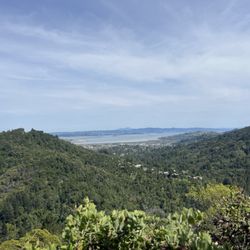
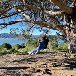
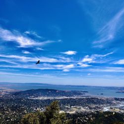
There's so much I still don't know and have yet to discover. After hiking at Hawk Hill and down to Battery Spencer the previous week, I quickly realized I've never been to Kirby Cove yet. So the following week on my day off, I returned to explore Kirby Cove. While walking down Kirby Cove Rd., I noticed there was a sign for Battery Wagner, which was only 0.3 miles away. I wanted to go to Kirby Cove first so I decided to explore this Battery Wagner on my way back up. A couple of hours later, I followed the trail that lead me to Battery Wagner. It's not on the main path so it's kinda tucked away in a secluded and hidden area. But my...this place is gorgeous. Eerie since I was the only one there, but the sweeping and panoramic views of Golden Gate Bridge and the city was mesmerizing. I explored the upper bunker/fortified observation room and I was in awe. I mean I've seen the view of Golden Gate Bridge on so many angles and I can never grow tired of it. But this was a completely different view altogether. Those military guys certainly know how to pick the best real estates and people would pay millions for this kind of view. So I had to dig deep and conduct some research on this particular battery and discovered that it's a reinforced concrete battery that held two (2) 5 inch M1897 guns. The battery was built during the Endicot Period as part of the coastal defense all along the west coast and construction started in 1899 and it was in operation from 1901 - 1917, so way before the bridge was built. It's named after 1st Lieutenant Orlando Wagner with the U.S. Engineers, who was mortally wounded during the U.S. Civil War. During World War I, large caliber coastal defense guns were ordered removed and were sent to arsenals for modification and mounting on mobile carriage, both railroad and wheeled and were thrust into service in Europe. The guns from Battery Wagner were dismounted and converted to wheeled carriages and made it's way to France on August 1918. After being put in service during World War I, the guns returned to the U.S. and were brought to Aberdeen Proving Ground on June 7, 1919. Battery Wagner is now part of the Golden Gate Recreation Area (GGNRA) administered by the National Park Service. So next time you're visiting Kirby Cove, take a detour to Battery Wagner for some adventure, exploration and great views. It's pretty secluded so you can chill here and maintain social distancing out in the open. #YelpChallenge2020 review No. 35 read more


Now this is what you call an 'en route' destination. I don't think it's enough to come here just to see this graffiti-covered vintage fortress, one of many along the ocean-facing coast. I came upon this spot walking on the wide trail from the more ballyhooed Battery Spencer down to hidden Kirby Cove. In the downward direction, it's quite noticeable because it's an odd sight from above on the trail, and you soon take a quick detour in what felt like a scene in "Apocalypse Now". Chances are pretty high that you'll be the only one there because it's a tad hazardous to climb on and around. If you are Golden Gate-obsessed, it provides another vantage point for your Instagram account as the views are quite nice. Now back to the trail... RELATED - Up in Marin? Here's a collection of places I've visited and reviewed: https://bit.ly/2tIHlkV read more


More info about Battery Wagner
Kirby Cove Rd
Mill Valley, CA 94941
Directions
Hours
Outdoor Amenities
You might also consider


Battery Wagner - hiking - Updated July 2026
Best of Mill Valley
People found Battery Wagner by searching for…
Hiking Trails in Mill Valley, CA
Walking Trails in Mill Valley, CA
View Points in Mill Valley, CA
Fishing Spots in Mill Valley, CA
Scenic View in Mill Valley, CA
Secret Spots in Mill Valley, CA
Secluded Spots in Mill Valley, CA
Things to Do in Mill Valley, CA
Things to Do on a Rainy Day in Mill Valley, CA
National Parks in Mill Valley, CA
Sunset Views in Mill Valley, CA
Hiking Club in Mill Valley, CA
Beautiful Views in Mill Valley, CA
Off Leash Dog Hikes in Mill Valley, CA
Running Trails in Mill Valley, CA
Photo Spots in Mill Valley, CA
Lookout Points in Mill Valley, CA
Off Road Trails in Mill Valley, CA
Parks and Recreation in Mill Valley, CA
Trending Searches in Mill Valley, CA
Blueberry Picking near Battery Wagner
Boat Tours near Battery Wagner
Cliff Jumping near Battery Wagner
Cruising Spots near Battery Wagner
Dog Friendly Things To Do near Battery Wagner
Jet Ski Rental near Battery Wagner
Kayak Rental near Battery Wagner
Kids Activities Indoor near Battery Wagner
Off Road Trails near Battery Wagner
Outdoor Activities near Battery Wagner
Peach Picking near Battery Wagner
Places To Walk Around near Battery Wagner
Public Shower near Battery Wagner
River Swimming near Battery Wagner
Rock Quarry near Battery Wagner
Scenic Night View near Battery Wagner
Scenic Overlook near Battery Wagner
State Parks near Battery Wagner
Swimming Holes near Battery Wagner
Swimming Lakes near Battery Wagner
Things To Do On A Rainy Day near Battery Wagner
Watch Sunset near Battery Wagner
Browse Articles
Browse Nearby
BEST of Mill Valley, California Coffee near Battery Wagner
BEST of Mill Valley, California Things to Do near Battery Wagner
BEST of Mill Valley, California Restaurants near Battery Wagner
BEST of Mill Valley, California Walking Trails near Battery Wagner
BEST of Mill Valley, California Parks near Battery Wagner
BEST of Mill Valley, California Breakfast near Battery Wagner
BEST of Mill Valley, California Campgrounds near Battery Wagner
BEST of Mill Valley, California Sightseeing near Battery Wagner
Browse Brands
Related Searches in Mill Valley, CA
Affordable Kayak Rental Services in Mill Valley, California
Best Dog Hiking Trails Around Mill Valley, California
Best Fishing Locations and Guides in Mill Valley, California
Best Nature Trails for Hiking in Mill Valley, California
Best Places for Horseback Riding in Mill Valley, California
Best Sightseeing Experiences Available in Mill Valley, California
Check Out Off Road Trails in Mill Valley, California
Discover Dog Friendly Trails to Explore in Mill Valley, California
Discover Easy Hiking Trails Near Mill Valley, California
Discover Kid Friendly Hiking Trails in Mill Valley, California
Discover Popular Bike Trails in Mill Valley, California
Discover a Hiking Trail in Mill Valley, California
Discover the Best Night Hike Trails in Mill Valley, California
Dog-Friendly Hikes With Dogs in Mill Valley, California
Enjoy Camping Adventures Around Mill Valley, California
Enjoy Kayaking Adventures in Mill Valley, California
Enjoy Off Leash Dog Hikes in Mill Valley, California
Enjoy Scenic Places to Walk in Mill Valley, California
Enjoy a Beautiful Waterfall Hike in Mill Valley, California
Enjoy the Best Walking Path in Mill Valley, California
Enjoy the Best Walking Trails in Mill Valley, California
Explore Beautiful Parks and Green Spaces in Mill Valley, California
Explore Easy Hikes Perfect for All in Mill Valley, California
Explore Fun Activities to Do in Mill Valley, California
Explore Popular Campgrounds Near Mill Valley, California
Explore Popular Dog Walking Trails in Mill Valley, California
Explore Top Dog Parks in Mill Valley, California Near You
Explore the Best Beach Spots in Mill Valley, California
Explore the Best Swimming Holes Around Mill Valley, California
Family Friendly Hiking With Kids in Mill Valley, California
Find Beautiful Views in Mill Valley, California
Find Cozy Camping Cabins in Mill Valley, California
Find Top Dog Friendly Parks to Visit in Mill Valley, California
Find Top-Rated Waterfalls in Mill Valley, California Now
Find the Best Parks for Picnics in Mill Valley, California
Hiking Trails With Waterfalls in Mill Valley, California
Off Leash Dog Hiking Trails in Mill Valley, California
Popular Outdoor Activities to Try in Mill Valley, California
Popular Picnic Spots to Visit in Mill Valley, California
Popular Waterfall Hiking Trails in Mill Valley, California
Safe River Swimming Areas in Mill Valley, California
Safe and Fun Parks for Kids in Mill Valley, California
Top Hiking Trails to Explore in Mill Valley, California
Top Playgrounds for Kids to Enjoy in Mill Valley, California
Top Running Trails to Explore in Mill Valley, California
Top Swimming Lakes to Enjoy in Mill Valley, California
Top Swimming Spots and Pools in Mill Valley, California
Visit Popular BBQ Park Locations in Mill Valley, California
Walk Dog Friendly Hiking Trails in Mill Valley, California
Walk the Best Paved Walking Trails in Mill Valley, California


