Cancel

    Open app

    Search

    The Inkwells

    3.6 (23 reviews)

    The Inkwells Photos

    You might also consider

    Recommended Reviews - The Inkwells

    Your trust is our priority, so businesses can't pay to alter or remove their reviews. Learn more about reviews.
    Yelp app icon
    Browse more easily on the app
    Review Feed Illustration

    Reviews With Photos

    Every single week the water at the Ink Wells is tested and LABELED: AVOID CONTACT!
    Heather H.

    You couldn't pay me to swim here, not matter how hot it is! All the septic systems that leak in the area, make there way to the ink wells. Having worked in the area, I always tell people to AVOID this bacteria fest. NASTY!

    Rita Y.

    A hidden little waterhole! The water doesn't look the cleanest but it's pretty cool and fun to swim & cliff jump in. Overall it's a little far out of the way in the middle of nowhere, but a fun stop if you're on the way to Point Reyes or Tomalas Bay I suppose. -- DIRECTIONS -- You can just put in the Yelp address and it will be fine. But from SF go on 101 N towards Marin. Take the San Anselmo Exit and you will merge onto Sir Francis Drake Blvd. After you pass the town of Lagunitas, watch out for a small bridge (Shafter Bridge) and the sign for Leo T. Cronin Fish Viewing Area. If you see the sign for Samuel P. Taylor State Park you've passed the bridge. -- PARKING -- Free! Park in the lot marked Leo T. Cronin Fish Viewing Area across from the Inkwells. From the parking lot walk across the bridge and away from the Samuel P. State Park. You will see a red bridge. Under the bridge is the inkwells.

    Marissa C.

    Cool little semi hidden gem in Marin County. My friend wanted to stop by here before our hike, and I was familiar of the place because it was featured on the news. Surprisingly, there was a small parking lot across the bridge which was nice. When we got here, only 2 other smaller groups were here. When we left, at least 3 other groups were coming in. I can only imagine how crowded it can get when schools not in session.

    Between all the drunks (it's an outdoor frat party and you're getting hazed), the litter (lots of broken glass for your enjoyment), the blight of graffiti, and most importantly the nasty bacteria-laden water (can you say E Coli, coliform, and Enterococcus bacteria present) I would avoid this place if you value your health and wellbeing.

    Carl T.

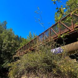
    Came here on a bike ride with daughter Sophie to find this place... Great road for motorcycles. The narrow little red footbridge is perpendicular to the road (visible from, but doesn't cross it) and almost across the street from the parking lot for Leo Cronin fish viewing area. Cool little spot to hang out for a while!

    Come on down to the waterhole and cool off.
    Ron W.

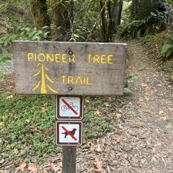
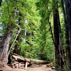
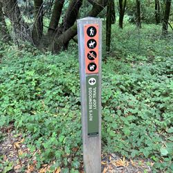
    When it's hot and you don't feel like freezing in the ocean water, don't want to go to a crowded beach, or don't like the idea of being shark food there is a special place you can go to cool off like people used to, at a waterhole. The Inkwells are small, deep, dark pools beside Sir Francis Drake Boulevard in Lagunitas, West Marin. Take North Route 68. Get off at Lagunitas Road and walk West (the same direction you were going) along Sir Francis Drake Boulevard until you reach Shafter Bridge.There is a little dirt path to the right of the bridge; follow it to the beautiful Inkwells! There are two pools, one is larger and easier to swim in. The creeks are fun to explore and wade in. Great place during the week when there are seldom many people. Good spot for picnics, photos, sunbathing, and even skinny dipping when no one's around. Water can be a little nippy at times but warms up some on hot days.

    My pup at the Inkwells!

    See all

    2 years ago

    Helpful 1
    Thanks 1
    Love this 0
    Oh no 1
    Photo of J K.
    9
    235
    3

    5 years ago

    Helpful 4
    Thanks 0
    Love this 1
    Oh no 0

    4 years ago

    Helpful 2
    Thanks 1
    Love this 2
    Oh no 5
    Photo of Greg C.
    0
    144
    35

    3 years ago

    Helpful 1
    Thanks 0
    Love this 1
    Oh no 2
    Photo of Heather H.
    182
    88
    43

    7 years ago

    Helpful 9
    Thanks 0
    Love this 3
    Oh no 0
    Photo of Kane D.
    165
    50
    4

    4 years ago

    Helpful 0
    Thanks 0
    Love this 0
    Oh no 0

    10 years ago

    Helpful 15
    Thanks 1
    Love this 4
    Oh no 0

    6 years ago

    Waited twenty minutes and the bro's left. Had a nice time dipping in the pools. An old standby in hot weather.

    Helpful 3
    Thanks 0
    Love this 3
    Oh no 0

    5 years ago

    Helpful 1
    Thanks 0
    Love this 0
    Oh no 0

    6 years ago

    Helpful 2
    Thanks 0
    Love this 0
    Oh no 0

    9 years ago

    Helpful 4
    Thanks 0
    Love this 1
    Oh no 0

    4 years ago

    Helpful 1
    Thanks 0
    Love this 0
    Oh no 0

    9 years ago

    Helpful 2
    Thanks 0
    Love this 2
    Oh no 0

    8 years ago

    Helpful 16
    Thanks 0
    Love this 1
    Oh no 0

    7 years ago

    Helpful 2
    Thanks 0
    Love this 1
    Oh no 0

    9 years ago

    Helpful 9
    Thanks 0
    Love this 0
    Oh no 0

    12 years ago

    Helpful 2
    Thanks 0
    Love this 1
    Oh no 1
    Photo of Jim A.
    8
    123
    62

    9 years ago

    Helpful 2
    Thanks 0
    Love this 0
    Oh no 0
    Photo of Ron W.
    4362
    197
    247

    12 years ago

    Helpful 7
    Thanks 0
    Love this 7
    Oh no 0

    12 years ago

    Helpful 5
    Thanks 0
    Love this 1
    Oh no 0
    Photo of Stacie N.
    376
    116
    6

    9 years ago

    Helpful 0
    Thanks 0
    Love this 0
    Oh no 0

    9 years ago

    Helpful 1
    Thanks 0
    Love this 4
    Oh no 0
    Photo of David S.
    147
    30
    34

    13 years ago

    Helpful 5
    Thanks 0
    Love this 2
    Oh no 0

    Ask the Community - The Inkwells

    Review Highlights - The Inkwells

    The water doesn't look the cleanest but it's pretty cool and fun to swim & cliff jump in.

    Mentioned in 2 reviews

    Read more highlights

    You might also consider

    Verify this business for free

    People searched for Swimming Pools 1,417 times last month within 15 miles of this business.

    Verify this business

    Pioneer Tree Trail

    Pioneer Tree Trail

    4.8(8 reviews)
    1.5 mi

    The trail is around a 2-mile loop nestled in Samuel P. Taylor Park…read more Parking is $8 so I think this hike is better if you are already at Samuel P. Taylor Park. Not that many people are here on the weekdays so it might be worth the parking fee for some extreme calm because the trail doesn't get as busy as some other trails in Marin. I felt it was very serene, and you were really away from it all here with just the sounds of the running creek and woodpeckers. Visually it's very shaded with lots of greenery and ferns. I always get a sandwich at Lagunitas Grocery store beforehand and eat it in the park.

    When my son suggested I hike the Pioneer Tree Trail he described it as easy and empty; he had never…read morebefore seen anyone on the trail and surmised that bringing my dog, whether permitted or not (he was unsure) would thus be no problem. He had obviously never been on the Pioneer Tree Trail on a summer weekend during a pandemic. Pioneer Tree Trail is a 2.1 mile loop trail that isn't flat but neither is there any significant elevation. It winds around and back and forth through beautiful Redwood groves and it's got a lot of charm. The fact that most people enter the trail from Samuel P. Taylor Park probably accounted for its popularity during my weekend, summertime visit. Children and families and groups who I'll assume were in some sort of Covid-bubble all seemed to be enjoying this hike on a sunny day. And even though she wasn't technically allowed, my dog enjoyed the easy to follow trail as well. If all you're looking for is a mellow stroll, go ahead and enter from the park. If you want more of a challenge though still no elevation, park on Sir Francis Drake Blvd. at Inkwells, cross the bridge on the north side of the road, and follow the flat, bike-friendly Cross Marin Trail to your left. When you cross the second bridge, do a u-turn and you'll encounter the entrance to the Pioneer Tree Trail. I have it on good authority that you can have this trail to yourself at most times, but I'd not rely on it during a summer weekend when people are itching to break out of their homes after months of sheltering in place.

    Photos
    Pioneer Tree Trail
    Pioneer Tree Trail
    Pioneer Tree Trail

    See all

    Point Reyes National Seashore - Tomales Point Trail - Tule Elk Preserve, Point Reyes National Seashore

    Point Reyes National Seashore

    4.7(407 reviews)
    5.6 mi

    How fortunate we are to have Point Reyes National Seashore. The headquarters is fantastic- maps,…read morerecommendations, nice restrooms & plenty of free parking. Today we chose the Bear Valley hike trail. The path is wide and mostly flat and even includes a bathroom midway. As you walk you are able to hear the beautiful sounds of the babbling brook along the route. Being late Spring we were able to spot a good amount of wildflowers- buttercups, poppies, bleeding heart, foxglove and more. We encountered several equestrian's throughout our hike.

    Sea How You Are A…read more71,000-acre park that was founded in 1962 and whose eastern boundary consists of a little thing called the San Andreas Fault. It's also home to over 900 plant species (50 of which are endangered), over 40 species of mammals, and over 400 different birds. Point Reyes is unlike any other park we've ever been to in that it's such a unique area that includes a small town, farmlands, estuaries, beaches, headlands, and so much more. If this is your first time or you're planning your first time, I'd try to allow for at least two full days to really get a feel for this place, and the best part is it's all 100% free to visit! Here's a quick guide to the best of the best things to do here (Pro Tip: There are multiple other Yelp pages with lots of more specific reviews for each of these locations). * The PR lighthouse is a must-see, and with the 308 stairs you'll need to get there, you'll definitely get your steps in! * There are multiple Visitors Centers, but if you only want to visit one, I'd recommend going to the one at Drake's Beach where you might get a glimpse of elephant seals during their breeding period (Dec - March). * Tomales Point Trail at the Tule Elk Preserve is my mostest favoritetest trail on Earth. It's relatively flat with very little uphill, but it is over nine miles if you want to get to the point and get back. And, yes, you'll want to get to the point. Otherwise, what's the point? ;) Just be sure to bring water and some snacks to cover you for those 9+ miles. This will also be your best chance to come face-to-face with the infamous Tule Elk. * Drake's Estero if you want to do some kayaking (check website for rules and dates). * McClures Beach if you want to hang and picnic. Great for tidepooling but not so much for swimming. Seriously. Don't do it. * Chimney Rock Trail is a relatively low effort for high reward spot for some spectacular views. There's plenty of other places to check out, but this should help get you started. Enjoy!

    Photos
    Point Reyes National Seashore - Tomales Point Trail - Tule Elk Preserve, Point Reyes National Seashore

    Tomales Point Trail - Tule Elk Preserve, Point Reyes National Seashore

    Point Reyes National Seashore - Tomales Point Trail - Tule Elk Preserve, Point Reyes National Seashore

    Tomales Point Trail - Tule Elk Preserve, Point Reyes National Seashore

    Point Reyes National Seashore - Tomales Point Trail - Tule Elk Preserve, Point Reyes National Seashore

    See all

    Tomales Point Trail - Tule Elk Preserve, Point Reyes National Seashore

    Alamere Falls - Point Reyes National Seashore - Honeysuckle  on the trail of Alamere Falls

    Alamere Falls - Point Reyes National Seashore

    4.6(565 reviews)
    5.4 mi

    People who have never been to Oregon will tell you that this is one of only two tidefalls (a…read morewaterfall that flows into the ocean) on the entire West Coast. People who believe AllTrails will tell you that this is one of only two tidefalls in California. (If you use Alltrails, you aren't allowed to hike with me, by the way.) Neither of these statements are anywhere close to true. As a matter of fact, there are at least two tidefalls on this one beach, and there are many more in areas that are not easily accessible to the public. Tidefalls are common along the coasts of Oregon, Washington, and Canada. There are several tall tidefalls in Cape Perpetua alone. That being said, Alamere Falls might be the biggest, prettiest publicly accessible tidefall in Northern California. I recently hiked Alamere Falls for the first time in nearly ten years, and I couldn't believe how much had seemed to change. First of all, the road to the Palomarin trail was hell in a compact vehicle. Even going like two miles per hour, I got a little motion sickness from the thousands of deep potholes. The road is so bad that it almost seems beyond repair. At this point, it's probably only suitable for high clearance vehicles, although I did not notice any signs warning of such. Secondly, I'm pretty sure I was the only sober person on the trail. The vibes were so, so weird. Consider packing your (legal) weapon of choice. Thirdly, I was certainly the only person to take the 'legal' trail down, although I gained some new perspective on this. While the trail that I took is ostensibly the trail recommended by NPS, one does have to wonder why it is so overgrown. It feels like, "Obviously, no one ever really hikes this trail," because it's nowhere near clear or well-trodden. Certain areas of the trail were so overgrown that it was impossible to see my feet, and difficult to find my footing. These areas were chalk full of poison oak, stinging nettle, poison hemlock, and a wide variety of (harmless) snakes. By contrast, much of the "social" trail was four feet wide, flat, and clear. Which made me wonder-- which trail is really safer? The cliffs at the end of the social trail are constantly crumbling. The risk of falling, breaking a leg, or at least spraining an ankle, seems high. But by contrast, the risk of spraining an ankle on the recommended trail seems high, too. And the stinging nettle hurt a lot, but only for a few hours. My personal recommendation is to take the recommended trail, but wear solid boots, long pants, and tall, colorful socks. Tuck your pants into your socks, or wear gaiters. Use permethrin or your tick repellant of choice. While the official Palomarin Trail may be very long and difficult, it's also worth the trouble. The ocean views and wildlife were unbelievable. I actually saw a mother deer nursing two spotted fawns in the middle of the trail. On the beach, I found agates, fossils, shells, giant bull kelp, snowy plovers, and lots of by-the-wind-sailors jellyfish in multiple stages of life and decomposition. The waterfall itself is pretty-- but make sure to check the tide!! I never do, and I almost always get stranded. The first time I ever hiked this trail, I actually had to climb up a cliff in terror and wait 3 hours for the tide to recede. But that doesn't need to happen to you if you remember to check the tide before you come out, while you still have service.

    Wow--absolutely spectacular, magical, and truly epic!…read more Alamere Falls is one of the most breathtaking hidden gems along the California coast, tucked inside Point Reyes National Seashore. What makes it so special is that it's a rare "tidefall," where the waterfall flows directly into the ocean--something you can only see in a couple of places in California, including McWay Falls. Watching the water cascade over the rugged shale cliffs onto the beach below is simply unforgettable. The surrounding landscape feels wild and untouched, adding to the sense of adventure. Upstream, the smaller cascades create a beautiful lead-up to the main falls, making the entire hike feel like a journey through nature's artwork. This spot is not just a destination--it's an experience. From the scenic hike to the dramatic ocean views, every moment feels rewarding. If you're looking for something unique, peaceful, and awe-inspiring, Alamere Falls absolutely delivers.

    Photos
    Alamere Falls - Point Reyes National Seashore - Top of the falls

    Top of the falls

    Alamere Falls - Point Reyes National Seashore
    Alamere Falls - Point Reyes National Seashore - Eucalyptus Grove at beginning of the trail

    See all

    Eucalyptus Grove at beginning of the trail

    Point Reyes National Seashore - Lighthouse

    Point Reyes National Seashore - Lighthouse

    4.4(262 reviews)
    5.6 mi

    Gorgeous day trip during good weather! If you're lucky you can see the ocean during a clear day…read morebut most times, there's a fog blanket. Beautiful lighthouse and view from the top. You can go down a ton of steps to see and learn about the lighthouse. Make sure to stop by Marin French Cheese Company on the way and bring a picnic of cheese, sandwiches to snack on. It's pretty windy down there too so bring layers and a jacket. You can explore the adjacent trails and do some hiking too. Definitely will get some Insta worthy photos!

    The Point Reyes Lighthouse contains the ORIGINAL first order Fresnel lens and clockworks that were…read moreon display at the 1867 World Fair in Paris. Not just a replica, but the actual model that was actually on display in Paris. The best time to see the inside of the lighthouse (where the lens and clockworks reside) is typically on weekends between 10am-noon and 1:30-3:30pm, but only in winds under 40mph, and (ideally), when it's not foggy. (Check the park website or call for current hours, which may fluctuate.) During these hours, rangers and volunteers are often around to answer questions, give educational talks, and sell merchandise. For safety reasons, the lighthouse and stairs are always closed to the public when the winds exceed 40mph-- which happens often. This is the windiest spot on the west coast. When you check the wind online, the results come from a weather station miles away from the lighthouse. Wind speeds may be much higher at the actual lighthouse than what you see online. To avoid wasting gas and time, you can always call the park visitor center (after 10am) to ask about the winds for that day. The Point Reyes lighthouse parking lot sits about a quarter mile away from the viewing platform above the lighthouse. This portion of the trail is accessible. There is also a closer accessible lot for those with handicapped placards. From the viewing platform, it's 313 stairs plus two steep slopes (of about 100 feet each) down to the actual lighthouse. The reason the lighthouse sits so low below the viewing platform is because the heavy fog that plagues the area is often just above this level. So, it's essentially below fog level-- except for when it's not. For those circumstances, there are foghorns. The modern foghorns are controlled by the coast guard, and are not on display. However, a large equipment-building-turned-museum, which sits at the same level as the lighthouse, houses several of the historic horns and air compressors, along with a few interpretive signs. In my personal opinion, the lighthouse could use a lot more pictures and interpretive signs. I personally think that it would be cool if these were plastered all over the inside of the lighthouse, like they are in Heceta. Is it worth the 313 stairs to see the lighthouse? I am the wrong person to answer this question, since, for me, the stairs have always been my main motivation for visiting. I would climb these stairs just for fun, and I've done so many times. And yes, I bought one of the "I survived the climb!" stickers from the visitor center at the top of the stairs, which is typically open the same hours as the lighthouse. The lens itself is pretty chipped up, but still beautiful to look at. I'm not sure if the chips are due to the weather, historic vandalism, or routine maintenance. What I do know is that the glass is technically irreplaceable. The original glass was made by French artisans in the 1800s. The modern replacement glass is manufactured in England, from different sand, which is apparently a different color and clarity than the original. Typically speaking, even when on display, the lighthouse is not rotated, and the curtains are kept mostly closed. Some people (me) might argue that it's deceptive to call it "fully functional" or claim that it's "in working order." That being said, the clockworks (a cabinet full of gears, pulleys, and cables) is pretty cool too see. It looks like a giant nineteenth century wind-up toy. The park keeps it painted, polished, and well-maintained. National Lighthouse Day is coming up on August 7th. Historically, including last year, the park has operated the lighthouse for this event. I haven't seen anything online about it yet, but maybe they'll celebrate this year, too. The nearest gas and food to the lighthouse are about thirty minutes away, so make sure you plan for that ahead of time. Chimney Rock is a short drive away. Drake's Beach (including the Ken Patrick visitor center), North Beach, South Beach, and the Cypress tree tunnel are all passed on the road between the lighthouse and Inverness, so if you plan right, you could definitely knock all of those sights out in one day. If you're a real overachiever, you could also add Tomales Point/Pierce Point Ranch to the same day, as the road to these destinations is between the lighthouse and Point Reyes Station.

    Photos
    Point Reyes National Seashore - Lighthouse - June 2025

    June 2025

    Point Reyes National Seashore - Lighthouse
    Point Reyes National Seashore - Lighthouse

    See all

    Palomarin Trailhead

    Palomarin Trailhead

    4.6(62 reviews)
    5.3 mi

    We decided to go up to Alamere Falls this Saturday morning. Parking lot was not that full yet at…read more8am, maybe about 8-10 cars. There are lots of parking at this trail but by afternoon, good luck!! I would definitely come here super early to beat the crowd like we did! The road going here is very zigzag roads and some may get sick. Also, the road is very narrow and lots of loose gravel and lots of potholes so drive with caution. The trails are very well maintained. Lots of people traffic though. We got there early so there was barely anyone there but by the time we started going back, I stopped counting after a hundred people! Very popular trail as everyone wanted to go to Alamere Beach Waterfalls! We didn't go to the campgrounds as it was too far. Just going to Alamere Falls and back was already over eight miles! Alamere trails is another different review! I really enjoyed this trail as it goes along the coast and see the ocean views! Just beware there is a lot of poison oak! I saw a lot along the trail! It's part shade so wear a hat. Some parts of the trails goes up and down and lots of loose rocks so you can sleep. I would rate this trail moderate to hard as it's a long trail! Good workout!! I totally enjoyed this trail but recommend to come really early if you come on the weekend!! [31st R]

    Can I go back to last Thursday when I hiked this trail?! I couldn't have asked for better weather,…read moresunny, light breeze, mid-70s, and best of all, pretty empty! I'm not sure how anyone can find this place because there are no marked signs or paved roads to get to the parking lot or base of the trail. As a passenger, I was oblivious to driving directions. I must say that all the twists and turns left me a bit car-sick and thankfully that quickly passed. There are about 4 restroom stalls in the parking lot that stunk badly. Now onto the positive aspects of Palomarin. Many reviewers have mentioned that this trail to the falls is about 8 miles round-trip. I think I finished in about 4.5 hours with stops here and there at a leisurely pace. I bet the sunset would have been beautiful, but I left around 6:30pm. What I love about this hike is that there's a little of everything in terms of views and things to see. I saw the ocean, a lake, a fox, waterfalls, nature, and fresh air. I wonder if the waterfalls are always flowing, even a few years ago during the drought... A great pit-stop before coming to Palomarin is to stop in Stinson Beach for lunch or dinner. I'm glad lunch was eaten before the hike. Next time I'll bring snacks. Luckily I had brought lots of water. Still having Palomarin withdraws... #53/2018

    Photos
    Palomarin Trailhead - Monkey flower

    Monkey flower

    Palomarin Trailhead
    Palomarin Trailhead

    See all

    Wildcat Camp

    Wildcat Camp

    4.4(24 reviews)
    5.6 mi

    Fog is burning off. He fires up the Jetboil…read more She probes him: "Say, What is this little rat-tail thing you've got going on?" He has a short braided thing of hair hanging off the back of his head, like he's a Padawan apprentice or something. "What, this?" he laughs. "Party in the back?" In a thicket by the creek, they sip coffee. Song of the thrush ascends. Seems to spiral to heaven upward like a shell. They gaze through a seven foot tall cow parsnip at the sky. The umbels are bobbing galaxies in a vast universe. Ever expanding. Wielding a magic wand, she identifies the plant: "Heracleum maximum!" It has gigantic leaves. Each one is connected to a thick, hollow, densely-haired stem. She steers the huge leaves on their thick stems in her slender arms. Swipes away the poison oak. "Found a path to the creek," she says cheerily. Clear water riffles and splits around a shoal. It's sandy with willows and cattails. There is a great blue heron in the reeds. The heron saunters forward deceptively, like a starlet at the Croisette, then recoils its long neck and strikes. "Bill stab!" he exclaims. He purses his mouth, throws his arm up and makes a fist. Taking a beat, she observes the scene, and says wryly "Sick, huge fan. What a bird." The impaled fish writhes on the heron's spear in the sun, scales glinting. It has met its immutable fate. They sit on a bank dotted with Cyperaceae. Lady beetles fly about. They turn and face each other. "F#$%#g sh*# show that was..." he moans. "What do you mean? We shucked a thousand shells. You have to respect your aunt's stamina, it's a Vibe!" she says, grinning. The moment is fleeting. The song and the chirping and the thrum of insects in the morning heat. They kill the coffee. It's time to pack up their tent and go. "Check out time!" she says. "Pack it up!"

    Beautiful campground and hike in, I took coast trail from bear valley and it was 8 miles... trail…read morewas very secluded after bear valley fire road... magical forest and garden surrounds the campgrounds. Camped at 2ab and it was ok, it was not very private and near the bathroom/water spigot so I felt like it was more people interaction than I cared for but that was what was available! The beach was a great place to relax after my hiking days and I loved it. I was there 3 days mid week in June and it was 75 one day and foggy/wet 60 degrees the other days, recommend rain fly for tents, and exploring the singletrack trails , they are so beautiful, full of wildlife

    Photos
    Wildcat Camp
    Wildcat Camp - Morning visitors

    Morning visitors

    Wildcat Camp

    See all

    The Inkwells - swimmingpools - Updated July 2026

    Loading...
    Loading...
    Loading...