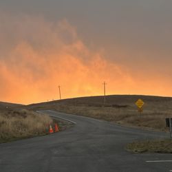
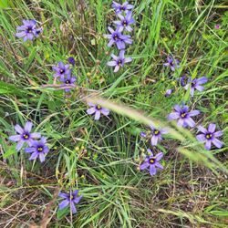
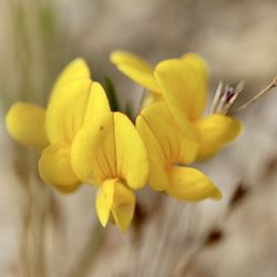
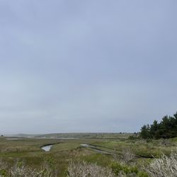
Glen Camp Photos


You might also consider
More like Glen Camp
Recommended Reviews - Glen Camp
Start your review...


14 years ago
12 years ago
Point Reyes national seashore is a day hikers and beachcombers paradise, with nearly all of its scenic treasures accessible from a drive-in trailhead or beach parking area. If you have the time and money, you can B&B it in style at Osprey Peak and enjoy oysters and wine at Saltwater in Inverness while hiking during the day. But there's more to Point Reyes than meets the eye. There's also the wilderness. The wilderness? The Phillip Burton Wilderness, actually. And wilderness areas are special - the most protected areas within the National Parks and National Forests in the US with the strictest rules regarding land use and recreation. You traverse the wilderness area on many hikes, but there are only 4 places (and about 50 sites) where you can overnight. Of the four, Glen Camp is to my mind the most secluded and therefore also the most "wildernessy" of the bunch. Wildcat and Coast camps are beach sites, extremely pretty but very popular and rather unprotected from the elements. Sky is closest to the road and the Bear Valley visitor center, which makes it good for folks w/ kids or tons of gear. It has sheltering trees but isn't as deep into the woods as Glen and further away from some of the scenic wonders: the lakes and Alamere falls and wildflower-covered ridges. And of the sites in Glen Camp, 005 and 006 are the most secluded, located up a hillside and under gorgeous tree canopies. Importantly, the toilets and water pump are out of sight up here, so you'll feel more in the woods than on the flat (and dusty) section below. It's not as OutThere! as Montana's Bob Marshall wilderness, but it's secluded and fun and full of forest sounds and sensations, which is all you really need, unless grizzly scat, snowmelt, and sage grouse are what you're after. http://www.yelp.com/biz_photos/glen-camp-point-reyes-station?select=gqO8uxAcbaNpw1BH3_iNUw#gqO8uxAcbaNpw1BH3_iNUw http://www.yelp.com/biz_photos/glen-camp-point-reyes-station?select=gqO8uxAcbaNpw1BH3_iNUw#6DTO7sDytgZWZjrpbpt7nA http://www.yelp.com/biz_photos/glen-camp-point-reyes-station?select=gqO8uxAcbaNpw1BH3_iNUw#uMfDaekmvtCXFMjYAVjC2w http://www.yelp.com/biz_photos/glen-camp-point-reyes-station?select=gqO8uxAcbaNpw1BH3_iNUw#QaLBtYeVRcDzAtHqIX28Vg From Glen Camp, you are perfectly positioned for a half-day loop hike to Wildcat Beach and back, using part of the epically scenic Lakes trail and getting a full-on forest meets the sea experience: the best Point Reyes wilderness experience you'll find. Lots of microclimates and intimate as well as expansive views. http://www.yelp.com/biz_photos/glen-camp-point-reyes-station?select=gqO8uxAcbaNpw1BH3_iNUw#5IMcDlW-oQ6fTTb218z6zw http://www.yelp.com/biz_photos/glen-camp-point-reyes-station?select=gqO8uxAcbaNpw1BH3_iNUw#MzaY0PU4X300QfK9T1R4UA http://www.yelp.com/biz_photos/glen-camp-point-reyes-station?select=gqO8uxAcbaNpw1BH3_iNUw#KkiBU7OVZQN1q6kJ3vwjNg http://www.yelp.com/biz_photos/glen-camp-point-reyes-station?select=gqO8uxAcbaNpw1BH3_iNUw#jHDmbp8uydgCTnq3_utLEw http://www.yelp.com/biz_photos/glen-camp-point-reyes-station?select=gqO8uxAcbaNpw1BH3_iNUw#j8kxoOJliLa9mpv5BkbRyA http://www.yelp.com/biz_photos/glen-camp-point-reyes-station?select=gqO8uxAcbaNpw1BH3_iNUw#aqfLOMz8P0RTFPZH7DVmYw Remember that you'll be one of 50-100 people around, probably less, once the evening sets in. Because you can't camp anywhere but the four designated spaces. And Glen gets fewer reservation requests than Wildcat or Coast. On the return to Bear Valley, don't take the shortest route to your car. Instead, set out on the Coast Trail to Arch Rock, then return to Bear Valley. You'll be rewarded with wonderful coastal views and - if you get an early start - you'll have the trails to yourself. Solitude is part of what Point Reyes' wilderness experience is all about. Glen Camp gives you a convenient base from which to explore the inner recesses during times of the day when the masses are still asleep or on the road. That's what makes it so special. read more


16 years ago
13 years ago
14 years ago
15 years ago
7 years ago
I loved this camping spot. We began the hike in from the Bear Valley Visitor Center, and was approximately a 4.6 mile hike in. We stayed in site 7, which was great. read more

7 years ago
A buddy and I went this past weekend to Glen Camp and we were hoping for no rain based on the weather forecast, but that didn't exactly happen. We were fairly well prepared for it except for arriving right and dusk and rain started coming down. I booked this trip several months in advance with the anticipation of their being some rain and made sure to reserve site 5 (6 looks good for these conditions as well) because of the tree coverage. I was very glad to see that the grass has been cut back along the trail after the bridge/bike racks. It's hard to find a campsite with good even ground for pitching a tent and this site was no different, but still totally manageable. You could probably pitch a total of no more than three 2-person tents (including putting one in the back trail area). The barbecue/cook rack is nice and low so if you wanted to sit around it with a camp chair while cooking food you could(no fires allowed/charcoal only for cooking :() and to get a little warmth, but we didn't use it. I have to agree with other people that Glen Camp is probably not as popular because once you are here (similar to Sky camp) there's not really anything to do unless you want to take another decent length hike to the beach. I would give Glen Camp overall 3.5 stars, and will perhaps plan another trip here again at site 6. read more

13 years ago
11 years ago
13 years ago
9 years ago
More info about Glen Camp
1 Bear Valley Rd
Point Reyes Station, CA 94956
Directions
(415) 663-8054
Call Now
Hours
Outdoor Amenities
Ask the Community - Glen Camp
Review Highlights - Glen Camp
You might also consider


Glen Camp - hiking - Updated July 2026
Best of Point Reyes Station
People found Glen Camp by searching for…
Campgrounds in Point Reyes Station, CA
Parks in Point Reyes Station, CA
Beaches in Point Reyes Station, CA
Hiking Trails in Point Reyes Station, CA
Picnic Spots in Point Reyes Station, CA
Things to Do in Point Reyes Station, CA
Free Campgrounds in Point Reyes Station, CA
Easy Hikes in Point Reyes Station, CA
Camping Sites in Point Reyes Station, CA
Waterfall Hike in Point Reyes Station, CA
Camping Cabins in Point Reyes Station, CA
Redwood Forest in Point Reyes Station, CA
Picnic Areas in Point Reyes Station, CA
Beaches for Kids in Point Reyes Station, CA
Sunrise View in Point Reyes Station, CA
Attractions in Point Reyes Station, CA
Picnic Areas BBQ Pits in Point Reyes Station, CA
Tent Camping in Point Reyes Station, CA
View Points in Point Reyes Station, CA
Scenic Drive in Point Reyes Station, CA
Scenic View in Point Reyes Station, CA
Visitor Centers in Point Reyes Station, CA
Trending Searches in Point Reyes Station, CA
Browse Articles
Browse Nearby
BEST of Point Reyes Station, California Restaurants near Glen Camp
BEST of Point Reyes Station, California Coffee near Glen Camp
BEST of Point Reyes Station, California Things to Do near Glen Camp
BEST of Point Reyes Station, California Beaches near Glen Camp
BEST of Point Reyes Station, California Picnic Areas near Glen Camp
BEST of Point Reyes Station, California Breakfast near Glen Camp
BEST of Point Reyes Station, California Lodging near Glen Camp
BEST of Point Reyes Station, California Campgrounds near Glen Camp
BEST of Point Reyes Station, California Taxis near Glen Camp
Browse Brands
Related Searches in Point Reyes Station, CA
Affordable Kayak Rental Services in Point Reyes Station, California
Best Dog Hiking Trails Around Point Reyes Station, California
Best Fishing Locations and Guides in Point Reyes Station, California
Best Places for Horseback Riding in Point Reyes Station, California
Best Sightseeing Experiences Available in Point Reyes Station, California
Check Out Off Road Trails in Point Reyes Station, California
Discover Dog Friendly Trails to Explore in Point Reyes Station, California
Discover Easy Hiking Trails Near Point Reyes Station, California
Discover Kid Friendly Hiking Trails in Point Reyes Station, California
Discover Popular Bike Trails in Point Reyes Station, California
Discover a Hiking Trail in Point Reyes Station, California
Discover the Best Night Hike Trails in Point Reyes Station, California
Dog-Friendly Hikes With Dogs in Point Reyes Station, California
Enjoy Camping Adventures Around Point Reyes Station, California
Enjoy Kayaking Adventures in Point Reyes Station, California
Enjoy Off Leash Dog Hikes in Point Reyes Station, California
Enjoy a Beautiful Waterfall Hike in Point Reyes Station, California
Enjoy the Best Walking Path in Point Reyes Station, California
Enjoy the Best Walking Trails in Point Reyes Station, California
Explore Beautiful Parks and Green Spaces in Point Reyes Station, California
Explore Easy Hikes Perfect for All in Point Reyes Station, California
Explore Fun Activities to Do in Point Reyes Station, California
Explore Popular Campgrounds Near Point Reyes Station, California
Explore Popular Dog Walking Trails in Point Reyes Station, California
Explore Top Dog Parks in Point Reyes Station, California Near You
Explore the Best Beach Spots in Point Reyes Station, California
Explore the Best Swimming Holes Around Point Reyes Station, California
Family Friendly Hiking With Kids in Point Reyes Station, California
Find Beautiful Views in Point Reyes Station, California
Find Popular Ziplining Spots Around Point Reyes Station, California
Find Top-Rated Waterfalls in Point Reyes Station, California Now
Find the Best Playgrounds to Visit in Point Reyes Station, California
Hiking Trails With Waterfalls in Point Reyes Station, California
Off Leash Dog Hiking Trails in Point Reyes Station, California
Picnic Areas With BBQ Pits Available in Point Reyes Station, California
Plan a Scenic Drive Route Near Point Reyes Station, California
Popular Outdoor Activities to Try in Point Reyes Station, California
Popular Picnic Spots to Visit in Point Reyes Station, California
Popular Waterfall Hiking Trails in Point Reyes Station, California
Safe River Swimming Areas in Point Reyes Station, California
Safe and Fun Parks for Kids in Point Reyes Station, California
Top Hiking Trails to Explore in Point Reyes Station, California
Top Playgrounds for Kids to Enjoy in Point Reyes Station, California
Top Running Trails to Explore in Point Reyes Station, California
Top Swimming Lakes to Enjoy in Point Reyes Station, California
Top Swimming Spots and Pools in Point Reyes Station, California
Top Things to Do With Kids in Point Reyes Station, California
Top-Rated Camping Sites in Point Reyes Station, California
Walk Dog Friendly Hiking Trails in Point Reyes Station, California
Walk the Best Paved Walking Trails in Point Reyes Station, California
People who viewed Glen Camp also viewed
Wildcat Camp
24 reviews
Tomales Point Trail - Tule Elk Preserve
136 reviews
Samuel P Taylor State Park
229 reviews
Doran Regional Park
162 reviews
Sonoma Coast State Beach
148 reviews
Laguna Trailhead
4 reviews
Bull Point Trail
5 reviews
Tomales Bluff
3 reviews
Point Reyes National Seashore
408 reviews
Pioneer Tree Trail
8 reviews