
Third Winchester Battlefield Trails Photos


You might also consider
More like Third Winchester Battlefield Trails
Recommended Reviews - Third Winchester Battlefield Trails
Start your review...

This was exactly what I was looking for: Low key historical location Close proximity to where I'm staying Mostly flat pebble lined trail (bugs love me!) 3-5 miles long, depending on which trail you pick Signage posts along the trail to explain events that took place read more


11 years ago
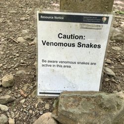
Outdoor joggers and dog walkers would be fine with this location, but Civil War aficionados should keep in mind this place is still a work in progress. There are two trailheads; this address is for one of them, located in the wood line of a nearby school. Park in their back parking lot. Ignore your GPS; it had fits trying to point me to the right place. The trail is just that; a somewhat circular gravel walking path thru the woods, with Civil War information plaques explaining key points of the battle every so often. Nothing fancy by any means. This place has no bathrooms and is very secluded. If you're adverse to walking thru the woods alone, you might not be comfortable here. http://www.civilwar.org/battlefields/thirdwinchester/maps/cwpt-third-winchester.html read more


4 years ago
7 years ago
11 years ago
9 years ago
More info about Third Winchester Battlefield Trails
251 First Woods Dr
Winchester, VA 22603
Directions
Hours
Outdoor Amenities
Ask the Community - Third Winchester Battlefield Trails


Why does Yelp recommend reviews?
Third Winchester Battlefield Trails - hiking - Updated July 2026
Best of Winchester
People found Third Winchester Battlefield Trails by searching for…
Walking Trails in Winchester, VA
Things to Do With Kids in Winchester, VA
Hiking Trails in Winchester, VA
Running Trails in Winchester, VA
Parks for Kids in Winchester, VA
Hiking With Kids in Winchester, VA
Free Things to Do in Winchester, VA
Stroller Walk in Winchester, VA
Swimming Holes in Winchester, VA
Scenic Views in Winchester, VA
Places to Take Pictures in Winchester, VA
River Swimming in Winchester, VA
Off Road Trails in Winchester, VA
Fun Places for Teens in Winchester, VA
Trending Searches in Winchester, VA
Boat Tours near Third Winchester Battlefield Trails
Cliff Jumping near Third Winchester Battlefield Trails
Cruising Spots near Third Winchester Battlefield Trails
Day Trips near Third Winchester Battlefield Trails
Dog Friendly Things To Do near Third Winchester Battlefield Trails
Kayak Rental near Third Winchester Battlefield Trails
Kids Activities Indoor near Third Winchester Battlefield Trails
Lakes near Third Winchester Battlefield Trails
Off Road Trails near Third Winchester Battlefield Trails
Outdoor Activities near Third Winchester Battlefield Trails
Peach Picking near Third Winchester Battlefield Trails
Public Shower near Third Winchester Battlefield Trails
Rainy Day Activities near Third Winchester Battlefield Trails
River Swimming near Third Winchester Battlefield Trails
Rock Quarry near Third Winchester Battlefield Trails
Scenic Night View near Third Winchester Battlefield Trails
Scenic Overlook near Third Winchester Battlefield Trails
State Parks near Third Winchester Battlefield Trails
Surf Shop near Third Winchester Battlefield Trails
Swimming Holes near Third Winchester Battlefield Trails
Swimming Lakes near Third Winchester Battlefield Trails
Things To Do On A Rainy Day near Third Winchester Battlefield Trails
Tubing near Third Winchester Battlefield Trails
U Pick Farms near Third Winchester Battlefield Trails
View Points near Third Winchester Battlefield Trails
Watch Sunset near Third Winchester Battlefield Trails
Browse Articles
Browse Nearby
BEST of Winchester, Virginia Restaurants near Third Winchester Battlefield Trails
BEST of Winchester, Virginia Things to Do near Third Winchester Battlefield Trails
BEST of Winchester, Virginia Coffee near Third Winchester Battlefield Trails
BEST of Winchester, Virginia Breakfast near Third Winchester Battlefield Trails
BEST of Winchester, Virginia Museums near Third Winchester Battlefield Trails
BEST of Winchester, Virginia Shopping near Third Winchester Battlefield Trails
Browse Brands
Related Searches in Winchester, VA
Affordable Canoe Rental Options in Winchester, Virginia
Affordable Kayak Rental Services in Winchester, Virginia
Best Dog Hiking Trails Around Winchester, Virginia
Best Fishing Locations and Guides in Winchester, Virginia
Best Places for Horseback Riding in Winchester, Virginia
Check Out Off Road Trails in Winchester, Virginia
Discover Dog Friendly Trails to Explore in Winchester, Virginia
Discover Easy Hiking Trails Near Winchester, Virginia
Discover Popular Bike Trails in Winchester, Virginia
Discover Scenic Mountain Bike Trails Near Winchester, Virginia
Discover a Hiking Trail in Winchester, Virginia
Discover the Best Night Hike Trails in Winchester, Virginia
Dog-Friendly Hikes With Dogs in Winchester, Virginia
Enjoy Camping Adventures Around Winchester, Virginia
Enjoy Exciting Mountain Biking Adventures in Winchester, Virginia
Enjoy Kayaking Adventures in Winchester, Virginia
Enjoy Off Leash Dog Hikes in Winchester, Virginia
Enjoy Tent Camping Spots Around Winchester, Virginia
Enjoy a Beautiful Waterfall Hike in Winchester, Virginia
Enjoy the Best Walking Trails in Winchester, Virginia
Explore Beautiful Parks and Green Spaces in Winchester, Virginia
Explore Easy Hikes Perfect for All in Winchester, Virginia
Explore Fun Activities to Do in Winchester, Virginia
Explore Popular Campgrounds Near Winchester, Virginia
Explore Top Dog Parks in Winchester, Virginia Near You
Explore Top Water Parks in Winchester, Virginia Today
Explore the Best Beach Spots in Winchester, Virginia
Explore the Best Swimming Holes Around Winchester, Virginia
Family Friendly Hiking With Kids in Winchester, Virginia
Find Beautiful Views in Winchester, Virginia
Find Popular Ziplining Spots Around Winchester, Virginia
Find Top Dog Swimming Spots in Winchester, Virginia
Find the Best Parks for Picnics in Winchester, Virginia
Find the Best Playgrounds to Visit in Winchester, Virginia
Hiking Trails With Waterfalls in Winchester, Virginia
Off Leash Dog Hiking Trails in Winchester, Virginia
Plan a Scenic Drive Route Near Winchester, Virginia
Popular Fishing Spots to Explore in Winchester, Virginia
Popular Outdoor Activities to Try in Winchester, Virginia
Popular Picnic Spots to Visit in Winchester, Virginia
Safe River Swimming Areas in Winchester, Virginia
Safe and Fun Parks for Kids in Winchester, Virginia
Top Hiking Trails to Explore in Winchester, Virginia
Top Paddleboarding Activities in Winchester, Virginia
Top Running Trails to Explore in Winchester, Virginia
Top Swimming Lakes to Enjoy in Winchester, Virginia
Top Swimming Spots and Pools in Winchester, Virginia