Buzzard Rock North Trail Photos


You might also consider
More like Buzzard Rock North Trail
Recommended Reviews - Buzzard Rock North Trail
Start your review...

Reviews With Photos

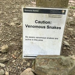
I found a hike not too far away from my house. I was lucky enough to find parking in one of the two small lots off the road. I made my way thru the trail as always, staying alert for bears and watching my step. The trail was nice and clean, moderately strenuous (not so hard), but pretty rocky. At times a good length of the path was just rocks. Didn't seem to take very long to get to the initial scenic view. It's a flattened out area of dirt and probably trees removed for the view. Hard to believe there's a mountain of trees except for this one bare spot. The view is ok. Here, I wondered what all the fuss was about. I've seen better views than this when I used to commute to work. Fairly disappointed, I ate breakfast bar and decided to follow the A.T. a bit further uphill. Before I knew it the ridge was bare rocks, jutting up like an enormous jawbone of carnivorous teeth! I saw some patches of pine trees just over the edge; I scrambled down carefully to get a better view of the mountains across from me. I was floored. I mean I've driven on Fort Valley Rd since I was 17 and I'm 51!! I never saw it from this view. It was stunning. I felt like I was in a far off place. So relaxing. I saw a handful of people rock climbing. Perfect spot for it. Great day for it. I must have stayed up there about 45 min following the jagged line of rocks and taking pics. The climbers were at the top and resting. After a while I figure it's time to go on back down. I prob got 1/2 way down the trail to the car and I hear what sounded somewhat like a man scream. Just one scream. I stopped for a min and looked back. Waited to see if I heard anything else.. Nothing....kept walking. I think I heard it again once I started walking a couple steps. It had to be loud. I was near the car lot. I then heard sirens all around just as I was making my last turn to the lot. An ambulance driver stopped and asked me if anyone was hurt. I guess a call was put in and they couldn't find where the issue was taking place. I said I thought I heard a man scream but they were rock climbing on the other side of the mtn. He said thank you for the help and he took off. I got in my car and decided to go over there to see if I said anything helpful. I mean to get on the otherside of the mtn you have to go almost 2 miles out then 1/2 mile down another road to get to the back side of where I just was... as soon as I turned onto the road cars were backed up. I knew what it was. How horrible. Rescue teams were quick. They were coming out in minutes and traffic was moving. I turned around in the dirt and went home. I've thought about it ever since. I hope the guy is ok. I feel bad. I was just watching them from the ridge. I'm glad my timing was well met with the ambulance. I'm sure the caller said Buzzard Rock, not knowing quickest access for a climber is on a whole other road. It's something I'll prob think about for quite a while. On another note. I saw lots of people hiking with no water or backpack. Always bring water on a hike. A backpack of first aid supplies would be helpful as well. You just never know. Be prepared.


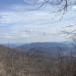
This trail was satisfying. I've been on longer hikes before, but never anything this challenging. It may be that I am severely out of shape too, lol. This was about 2.5 miles up and down. Very steep at the end. The view that I thought was the summit was breathtaking. We soon realized there was about 100 more yards to explore. This was all stones, bigger. There were about five more overlooks that opened up. This was truly the top. The breeze was satisfying and the views were serene and immaculate. Highly recommended.

Beautiful trail! However, the trail is very challenging. It's is very rocky. I tripped several times. There are very steep sections (30 degrees or more). The trail, unfortunately, is not labeled well. I went with my family(6 of us which includes a 4 and 10 year old), it took us about 3 hours to get to the top and back.

Let me start by saying parking isn't great here. Allow 30 extra minutes to your trip, then just wait in the parking lot for a space to open. People leave pretty steadily. Be patient because it's worth it. Now, on to the trail. Perfect hiking trail. It's rocky, so requires you to watch your step but very doable. Slightly uphill hike there but manageable. The last 10 feet before the 1st summit is very steep and rocky, so be prepared. We stopped at the 1st summit due to time constraints, but my goodness it was beautiful. The whole trail is beautiful. Very wonderful trail. Will be back!

Wow what a great trail!! We had a few 5 year old kids with us that couldn't quite make it to the second overlook but easily made it to the first one. It was a spectacular view! It's about 2 hours up and a little over an hour back. The last 20 minutes is all rock and Amazingness. I definitely recommend this for anyone that wants a small challenge but not to difficult.

2 years ago
Moderate due to rocky terrain but well maintained, nice shade up and down trail crosses creek. Beautiful view. read more


4 years ago
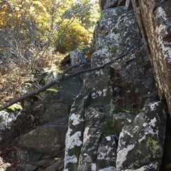
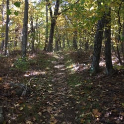
This hike is a great out and back trail and not too far out there especially if you're coming from DC. It's not in a National park either so no fees! Roughly 2 miles out and 2 miles back in, this hike doesn't get particularly steep until maybe the last .5 mile up the ridge. But of rock scrambling and cobbles on the trail so ankle support is recommended but not necessary. The white blazes are well marked and helpful with all the fall leaf litter. Dog friendly but probably nicer if your dog is a little bit taller (saw a corgi and a dachshund being carried by their owners for the rock scrambling). Our coonhound had a great time. No trash can so be prepared to pack out all garbage. Only con is limited and steep parking which can get dicey if the lot is full. Come early on a nice weekend day and you should be fine. Trail itself did not feel overly crowded. read more
Buzzard Rock North Trail is a popular, highly traveled trail in the George Washington National Forest not far from Front Royal and Shenandoah. There is no entry fee for GWNF as opposed to Shenandoah so that's something to keep in mind too. The parking lot is poorly marked, but I found no trouble parking at 3pm on a Saturday. In fact, I never saw more than 7-10 people throughout my up and back hike. At times the terrain can be steep and it's much different than Shenandoah-it's very rocky and filled with tree roots. The first overlook you come to is beautiful but be sure to keep going for some fun rock scrambles and more breathtaking views. The trail is both child and dog friendly and is well marked. It can get muddy after rainfall, so consider your footwear when hiking. read more


4 years ago
I found a hike not too far away from my house. I was lucky enough to find parking in one of the two small lots off the road. I made my way thru the trail as always, staying alert for bears and watching my step. The trail was nice and clean, moderately strenuous (not so hard), but pretty rocky. At times a good length of the path was just rocks. Didn't seem to take very long to get to the initial scenic view. It's a flattened out area of dirt and probably trees removed for the view. Hard to believe there's a mountain of trees except for this one bare spot. The view is ok. Here, I wondered what all the fuss was about. I've seen better views than this when I used to commute to work. Fairly disappointed, I ate breakfast bar and decided to follow the A.T. a bit further uphill. Before I knew it the ridge was bare rocks, jutting up like an enormous jawbone of carnivorous teeth! I saw some patches of pine trees just over the edge; I scrambled down carefully to get a better view of the mountains across from me. I was floored. I mean I've driven on Fort Valley Rd since I was 17 and I'm 51!! I never saw it from this view. It was stunning. I felt like I was in a far off place. So relaxing. I saw a handful of people rock climbing. Perfect spot for it. Great day for it. I must have stayed up there about 45 min following the jagged line of rocks and taking pics. The climbers were at the top and resting. After a while I figure it's time to go on back down. I prob got 1/2 way down the trail to the car and I hear what sounded somewhat like a man scream. Just one scream. I stopped for a min and looked back. Waited to see if I heard anything else.. Nothing....kept walking. I think I heard it again once I started walking a couple steps. It had to be loud. I was near the car lot. I then heard sirens all around just as I was making my last turn to the lot. An ambulance driver stopped and asked me if anyone was hurt. I guess a call was put in and they couldn't find where the issue was taking place. I said I thought I heard a man scream but they were rock climbing on the other side of the mtn. He said thank you for the help and he took off. I got in my car and decided to go over there to see if I said anything helpful. I mean to get on the otherside of the mtn you have to go almost 2 miles out then 1/2 mile down another road to get to the back side of where I just was... as soon as I turned onto the road cars were backed up. I knew what it was. How horrible. Rescue teams were quick. They were coming out in minutes and traffic was moving. I turned around in the dirt and went home. I've thought about it ever since. I hope the guy is ok. I feel bad. I was just watching them from the ridge. I'm glad my timing was well met with the ambulance. I'm sure the caller said Buzzard Rock, not knowing quickest access for a climber is on a whole other road. It's something I'll prob think about for quite a while. On another note. I saw lots of people hiking with no water or backpack. Always bring water on a hike. A backpack of first aid supplies would be helpful as well. You just never know. Be prepared. read more


3 years ago
9 years ago
Only 80 Miles from DC, this trail offers splendid views. The approximate address is 3085 Mountain Rd Front Royal, VA by the way. The parking lot is weirdly shaped, but it does the job. The two-mile hike is a tad difficult as it is very rocky. However, the views are amazing. read more


9 years ago
This trail was satisfying. I've been on longer hikes before, but never anything this challenging. It may be that I am severely out of shape too, lol. This was about 2.5 miles up and down. Very steep at the end. The view that I thought was the summit was breathtaking. We soon realized there was about 100 more yards to explore. This was all stones, bigger. There were about five more overlooks that opened up. This was truly the top. The breeze was satisfying and the views were serene and immaculate. Highly recommended. read more


 - Hiking Near Me - Front Royal, Virginia")
8 years ago
Beautiful trail! However, the trail is very challenging. It's is very rocky. I tripped several times. There are very steep sections (30 degrees or more). The trail, unfortunately, is not labeled well. I went with my family(6 of us which includes a 4 and 10 year old), it took us about 3 hours to get to the top and back. read more


7 years ago
Let me start by saying parking isn't great here. Allow 30 extra minutes to your trip, then just wait in the parking lot for a space to open. People leave pretty steadily. Be patient because it's worth it. Now, on to the trail. Perfect hiking trail. It's rocky, so requires you to watch your step but very doable. Slightly uphill hike there but manageable. The last 10 feet before the 1st summit is very steep and rocky, so be prepared. We stopped at the 1st summit due to time constraints, but my goodness it was beautiful. The whole trail is beautiful. Very wonderful trail. Will be back! read more


11 years ago
Wow what a great trail!! We had a few 5 year old kids with us that couldn't quite make it to the second overlook but easily made it to the first one. It was a spectacular view! It's about 2 hours up and a little over an hour back. The last 20 minutes is all rock and Amazingness. I definitely recommend this for anyone that wants a small challenge but not to difficult. read more

6 years ago
9 years ago
5 stars for kids and parents who aren't sissies. Awesome mix of elevation, rock climbs and water obstacles for the young ones. Some hair raising moments for the little ones, but that is why God gave us more then 1, right? Really, 7 and 12 yo handled it like pros. 4 mile round trip. Pretty well marked, follow the lowercase "i" marked on trees and make it up the ridge till you see a rock opening tike a V. Parking is tight and they will tow you if you park on the street. Directions also sucked the donkey, its off of mountain road near the fish hatchery. Good luck. read more


11 years ago
More info about Buzzard Rock North Trail
Ask the Community - Buzzard Rock North Trail
Review Highlights - Buzzard Rock North Trail


Buzzard Rock North Trail - hiking - Updated July 2026
Best of Front Royal
People found Buzzard Rock North Trail by searching for…
Things to Do in Front Royal, Virginia
Fishing in Front Royal, Virginia
Parks in Front Royal, Virginia
Rock Climbing in Front Royal, Virginia
Hiking Trails in Front Royal, Virginia
Sunset View in Front Royal, Virginia
Scenic View in Front Royal, Virginia
Fun Things to Do With Kids in Front Royal, Virginia
Scenic Drive in Front Royal, Virginia
Scenic Overlook in Front Royal, Virginia
Lookout Points in Front Royal, Virginia
Hiking With Kids in Front Royal, Virginia
Running Trails in Front Royal, Virginia
Waterfall Hike in Front Royal, Virginia
Easy Hikes in Front Royal, Virginia
Places to Take Pictures in Front Royal, Virginia
View Points in Front Royal, Virginia
Dog Friendly Trails in Front Royal, Virginia
Night Hike in Front Royal, Virginia
Free Campgrounds in Front Royal, Virginia
Rock Quarry in Front Royal, Virginia
Places to Walk Around in Front Royal, Virginia
Trending Searches in Front Royal, VA
4th Of July Fireworks near Buzzard Rock North Trail
Black Owned Nail Salons near Buzzard Rock North Trail
Boat Rental near Buzzard Rock North Trail
Cliff Jumping near Buzzard Rock North Trail
Day Trips near Buzzard Rock North Trail
Dog Friendly Trails near Buzzard Rock North Trail
Fireworks near Buzzard Rock North Trail
Kayak Rental near Buzzard Rock North Trail
Lakes & Ponds near Buzzard Rock North Trail
Off Road Trails near Buzzard Rock North Trail
Outdoor Activities near Buzzard Rock North Trail
Places To Swim near Buzzard Rock North Trail
Public Pools near Buzzard Rock North Trail
Public Shower near Buzzard Rock North Trail
River Swimming near Buzzard Rock North Trail
Rock Quarry near Buzzard Rock North Trail
Running Trails near Buzzard Rock North Trail
Scenic Overlook near Buzzard Rock North Trail
Splash Pad near Buzzard Rock North Trail
Strawberry Picking near Buzzard Rock North Trail
Sunrise View near Buzzard Rock North Trail
Swimming Holes near Buzzard Rock North Trail
Swimming Lakes near Buzzard Rock North Trail
Watch Sunset near Buzzard Rock North Trail
Browse Articles
Browse Nearby
BEST of Front Royal, Virginia Scenic View near Buzzard Rock North Trail
BEST of Front Royal, Virginia Restaurants near Buzzard Rock North Trail
BEST of Front Royal, Virginia Coffee near Buzzard Rock North Trail
BEST of Front Royal, Virginia Things to Do near Buzzard Rock North Trail
BEST of Front Royal, Virginia Parks near Buzzard Rock North Trail
BEST of Front Royal, Virginia Breakfast near Buzzard Rock North Trail
BEST of Front Royal, Virginia Caves near Buzzard Rock North Trail
BEST of Front Royal, Virginia Hot Springs near Buzzard Rock North Trail
BEST of Front Royal, Virginia Campgrounds near Buzzard Rock North Trail
Browse Brands
Related Searches in Front Royal, VA
Affordable Kayak Rental Services in Front Royal, Virginia
Best Fishing Locations and Guides in Front Royal, Virginia
Best Places for Horseback Riding in Front Royal, Virginia
Check Out Off Road Trails in Front Royal, Virginia
Discover Dog Friendly Trails to Explore in Front Royal, Virginia
Discover Scenic Mountain Bike Trails Near Front Royal, Virginia
Discover a Hiking Trail in Front Royal, Virginia
Discover the Best Night Hike Trails in Front Royal, Virginia
Dog-Friendly Hikes With Dogs in Front Royal, Virginia
Enjoy Camping Adventures Around Front Royal, Virginia
Enjoy Exciting Mountain Biking Adventures in Front Royal, Virginia
Enjoy Kayaking Adventures in Front Royal, Virginia
Enjoy River Tubing Adventures in Front Royal, Virginia
Enjoy Tent Camping Spots Around Front Royal, Virginia
Enjoy a Beautiful Waterfall Hike in Front Royal, Virginia
Enjoy the Best Tubing Experiences in Front Royal, Virginia
Enjoy the Best Walking Trails in Front Royal, Virginia
Experience Thrilling White Water Rafting in Front Royal, Virginia
Explore Beautiful Parks and Green Spaces in Front Royal, Virginia
Explore Easy Hikes Perfect for All in Front Royal, Virginia
Explore Fun Activities to Do in Front Royal, Virginia
Explore Popular Campgrounds Near Front Royal, Virginia
Explore Popular Scenic Overlook Points in Front Royal, Virginia
Explore Scenic Lakes to Visit in Front Royal, Virginia
Explore Top Dog Parks in Front Royal, Virginia Near You
Explore Top Water Parks in Front Royal, Virginia Today
Explore the Best Boating Spots in Front Royal, Virginia
Explore the Best Swimming Holes Around Front Royal, Virginia
Family Friendly Hiking With Kids in Front Royal, Virginia
Find Beautiful Views in Front Royal, Virginia
Find Cozy Camping Cabins in Front Royal, Virginia
Find Popular Ziplining Spots Around Front Royal, Virginia
Find Top Dog Swimming Spots in Front Royal, Virginia
Find the Best Playgrounds to Visit in Front Royal, Virginia
Find the Best Scenic View Locations in Front Royal, Virginia
Hiking Trails With Waterfalls in Front Royal, Virginia
Off Leash Dog Hiking Trails in Front Royal, Virginia
Plan a Scenic Drive Route Near Front Royal, Virginia
Popular Fishing Spots to Explore in Front Royal, Virginia
Popular Outdoor Activities to Try in Front Royal, Virginia
Popular Picnic Spots to Visit in Front Royal, Virginia
Safe River Swimming Areas in Front Royal, Virginia
Safe and Fun Parks for Kids in Front Royal, Virginia
Top Climbing Spots and Gyms in Front Royal, Virginia
Top Paddleboarding Activities in Front Royal, Virginia
Top Playgrounds for Kids to Enjoy in Front Royal, Virginia
Top Running Trails to Explore in Front Royal, Virginia
Top Swimming Lakes to Enjoy in Front Royal, Virginia