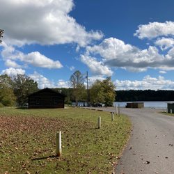
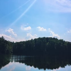
Blue Hole Photos


You might also consider
More like Blue Hole
Recommended Reviews - Blue Hole
Start your review...

2 months ago


1 year ago
2 years ago
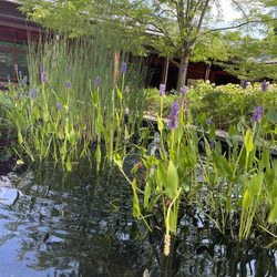
An amazing summer adventure! Be warned, there is no cell signal up in the area so screenshot directions before going. The drive there is beautiful itself. There are no signs that direct you to the swimming hole. The trail is flat/uphill for about 1.5 miles. Be wary of snakes in grass. The swimming hole is amazing. The water was frigid but refreshing after the hike! There is a rope swing which was pretty sturdy when I used it. Water shoes are recommended since the rocks get slippery. The water hole gets pretty deep, enough for me to jump in and not touch the bottom! It's a perfect summer activity with a large group of friends. read more


6 years ago
9 years ago
7 years ago
16 years ago
More info about Blue Hole
Charlottesville, VA 22901
Directions
Hours
Outdoor Amenities
Ask the Community - Blue Hole


Blue Hole - hiking - Updated June 2026
Best of Charlottesville
People found Blue Hole by searching for…
Things to Do in Charlottesville, Virginia
Parks in Charlottesville, Virginia
Hiking Trails in Charlottesville, Virginia
Playgrounds in Charlottesville, Virginia
Dog Swimming in Charlottesville, Virginia
Beautiful Views in Charlottesville, Virginia
Secret Spots in Charlottesville, Virginia
Off Road Trails in Charlottesville, Virginia
Walking Trails in Charlottesville, Virginia
Swimming Lakes in Charlottesville, Virginia
Things to Do on a Rainy Day in Charlottesville, Virginia
Swimming Holes in Charlottesville, Virginia
River Swimming in Charlottesville, Virginia
Swimming in Charlottesville, Virginia
Hiking Groups in Charlottesville, Virginia
Heated Pool in Charlottesville, Virginia
Masters Swimming in Charlottesville, Virginia
Diving Boards in Charlottesville, Virginia
Waterpark in Charlottesville, Virginia
Places to Go in Charlottesville, Virginia
Fall Foliage in Charlottesville, Virginia
Sunrise View in Charlottesville, Virginia
Trending Searches in Charlottesville, VA
Browse Nearby
Browse Brands
Related Searches in Charlottesville, VA
Affordable Kayak Rental Services in Charlottesville, Virginia
Best Fishing Locations and Guides in Charlottesville, Virginia
Best Gym With Sauna Amenities in Charlottesville, Virginia
Best Gyms With Swimming Pools in Charlottesville, Virginia
Best Parks for Parties and Events in Charlottesville, Virginia
Best Places for Horseback Riding in Charlottesville, Virginia
Best Spinning Classes Offered in Charlottesville, Virginia
Best Water Parks for Kids in Charlottesville, Virginia
Check Out Off Road Trails in Charlottesville, Virginia
Comprehensive Pool Maintenance Services in Charlottesville, Virginia
Discover Dog Friendly Trails to Explore in Charlottesville, Virginia
Discover Fun Toddler Parks in Charlottesville, Virginia for Your Little One
Discover Heated Swimming Pool Venues in Charlottesville, Virginia
Discover Kid Friendly Hiking Trails in Charlottesville, Virginia
Discover Public Swimming Pools in Charlottesville, Virginia
Discover Scenic Mountain Bike Trails Near Charlottesville, Virginia
Discover a Free Swimming Pool Near You in Charlottesville, Virginia
Discover a Hiking Trail in Charlottesville, Virginia
Discover the Best Beaches in Charlottesville, Virginia
Discover the Best Night Hike Trails in Charlottesville, Virginia
Dog-Friendly Hikes With Dogs in Charlottesville, Virginia
Enjoy Camping Adventures Around Charlottesville, Virginia
Enjoy Exciting Mountain Biking Adventures in Charlottesville, Virginia
Enjoy Indoor Lap Pool Facilities in Charlottesville, Virginia
Enjoy Kayaking Adventures in Charlottesville, Virginia
Enjoy River Tubing Adventures in Charlottesville, Virginia
Enjoy Tent Camping Spots Around Charlottesville, Virginia
Enjoy a Beautiful Waterfall Hike in Charlottesville, Virginia
Enjoy a Refreshing Lap Pool in Charlottesville, Virginia
Enjoy the Best Picnic Spots and Ideas in Charlottesville, Virginia
Enjoy the Best Tubing Experiences in Charlottesville, Virginia
Enjoy the Best Walking Trails in Charlottesville, Virginia
Expert Inground Pool Installation in Charlottesville, Virginia
Explore Beautiful Parks and Green Spaces in Charlottesville, Virginia
Explore Fun Activities to Do in Charlottesville, Virginia
Explore Hot Tubs and Spas Options in Charlottesville, Virginia
Explore Popular Campgrounds Near Charlottesville, Virginia
Explore Popular Recreation Centers Around Charlottesville, Virginia
Explore Popular Sports Clubs in Charlottesville, Virginia
Explore Scenic Lakes to Visit in Charlottesville, Virginia
Explore Top Dog Parks in Charlottesville, Virginia Near You
Explore Top Gyms in Charlottesville, Virginia Now
Explore Top Water Parks in Charlottesville, Virginia Today
Explore Volleyball Courts Available in Charlottesville, Virginia
Explore the Best Beach Spots in Charlottesville, Virginia
Explore the Best Boating Spots in Charlottesville, Virginia
Explore the Best Swimming Holes Around Charlottesville, Virginia
Family Friendly Hiking With Kids in Charlottesville, Virginia
Browse Articles
People who viewed Blue Hole also viewed
Walnut Creek Park
19 reviews
Rivanna Trail
10 reviews
Chris Greene Lake
18 reviews
Sherando Lake
14 reviews
Ivy Creek Natural Area
17 reviews
Humpback Rocks Visitor Center and Farm Museum
6 reviews
Beaver Creek Lake
4 reviews
Saunders-Monticello Trail
17 reviews
Preddy Creek Trails Park
5 reviews
Appalachian Trail - Rockfish Gap Trailhead
5 reviews