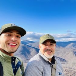
White Oak Canyon Trail Photos


You might also consider
More like White Oak Canyon Trail
Recommended Reviews - White Oak Canyon Trail
Start your review...

Reviews With Photos

It's the holiday weekend to take advantage of a full day hike. Since its one of the days that the national parks are free, I decided to accomplish one of the trails at Shenandoah National Park. Who doesn't love free? White Oak is about 5 miles round trip but there is also a connecting loop, Cedar run, that turns the total trail to about 9 miles. I always choose the longest trail possible. After driving for almost 3 hours, I almost decided against it but if there's no pain, there's no gain so I stuck with it. White oak has an entrance from Skyline drive or from the bottom of the mountain which is where a lot of reviews recommended to start from. Parking always seem to be an issue so its a good idea to always leave early to snag a spot. Luckily this time parking was not an issue even though I thought arriving near noon was late. While I enjoyed the hike up along the White Oak trail, I did not relish Cedar Run as much. White Oak was wonderful with many scenic points such as waterfalls and overlooks. Although it was steep, it was a breeze compared to the descent on Cedar Run. It is my fault that I did not come readily prepared. At around 5 miles to trek down, it felt forever to complete. Along with frigid temperatures, an icey, treacherous trail, and no mittens like Bernie Sanders for my cold to the bone hands, I wished to turn around. Perseverance is key! Total time to complete was about 6 hours. My legs are still bruised and sore. It looks fun in the summer. Maybe I'll check back then.

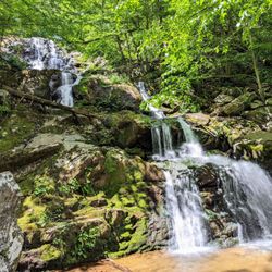
It's been a couple of years since we last hiked this trail. This time we were staying at a Lodge in nearby Syria and discovered that the trailhead is only 5 miles away so naturally decided to go back despite the weather not being optimal (looked rainy but turned out to be just overcast thankfully). It's one of the most popular trails in the park although not a lot of people on a weekday. Second time around it didn't feel as strenuous as the first time, as we knew what to expect. It's only 1.4 miles to the first (lower) waterfall, so a rewarding short hike if not going further. It's a moderate steady climb mixed with some flat parts, well marked, a bit more rocky surface for first half of the trail, not that difficult if going slowly. The second (upper) waterfall is an additional 1.5 miles with similar but less rocky terrain. Both falls are equally beautiful so if you have the time and energy definitely keep going. This is a scenic hike but no sweeping views at the top - just enjoy the beautiful foliage and the sound and sight of the falls. This trailhead is not at a park entrance but there is a ranger station and entrance/parking fees apply unless you already have a park pass.

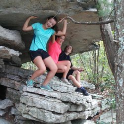
If you want to go to Shenandoah but don't want to do old rag--this is the perfect trail for you, especially in the summer. Bring your swimsuit bc there's at least 2-3 places you can swim in. There's one particular area where you can go down nature's slide. The water is refreshingly cold, and the slide is scary in my opinion, but worth a try! Just don't have too many people go at once, I think I saw someone almost go over once bc of that. This trail has a lot of incline so be wary and wear footwear that will prevent blisters. The view at the end is...okay to be honest. Since the waterfall is all the way to the right, it is kind of blocked, so really I think the highlight of the trail is mostly getting a great hike in and hiking through waterfalls/jumping into the water. Sadly I can't seem to upload the videos of the water slide but trust me and bring something you can get into the water with (and to dry off)!

White Oak - Cedar Run trail - starting from the parking located @ 45 1/2 mile marker is a strenuous hike that is about 8 miles long but after age of 40 it seems to have increased in length. It is one of the top 3 hikes in our region - other two being: Old Rag & Billy Goat), but it is not for everybody. A group of young people started unprepared (bad shoes and not enough water) and their comments varied from, "OMG, look at the beautiful waterfall," at the second one to, "Damn waterfalls!" at 6th waterfall. It is equivalent to climbing 108 stories or 27,000 steps. There is a danger of slipping, even more when your muscles are exhausted. Never the less, come prepared, take the challenge or choose another nearby beautiful hike like "Dark Hollow Falls" that is friendlier.


This is a great day hike (probably my favorite in the DC area) full of waterfalls, natural water slides, natural springs/streams, and well taken care of trails. I would definitely plan on getting in the water at some point since there are so many opportunities and the water is crystal clear and refreshing. There are 3 separate access points and each has its own parking lot, so if you do not want to hike the entire trail you can just park closest to the destination you are trying to visit (I.e. waterfall, slide, quarry/cliff, etc.). It is dog friendly and the full trail is around 8-9 mi. but a lot of folks just do a portion of the trail. If you are doing the full trail I would park at the bottom of the mountain and not at either of the entrances off of Skyline Drive, just a personal preference. The full trail gives you a little bit of everything, including a fire pass trail connecting the steep incline and declines. There are lots of cascading waterfalls, pools of clear springs, and natural slides tat you can take advantage of. The first waterfall area is usually a bit crowded but if you hike the entire trail you will lose the crowds away from the parking lots. Great hike for any level of hikers and worth the hour and 30 from DC.

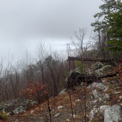
Very crowded, but you can get your waterfall fix here. Due to the elevation, the greens come late - I visited on a Saturday in late April, and the trees were still rather bare. To avoid the crowds, try going ridiculously early on the weekend, or better yet, visit on a weekday. Note that Skyland Resort is a short walk from the top of the trail, when you get to Skyline Drive. You may be able to find water and/or food there.

After the week of rain we had we thought this weekend would be perfect for this hike. Right we were. The river was raging and after the second bridge it followed the trail beside us. We hiked 3.5 miles down to just after the half way sign. Halfway? Yep! It was so adventurous and fun crossing the water and climbing up on the cliff to see the waterfall. There were several and each was so amazing. Water was even coming out of the cliffs like a shower! It's slippery so watch out. The trip back of course was uphill but it really wasn't bad compared to other uphill trails I've been on. Great hike and great scenery after the rains. Enjoy!

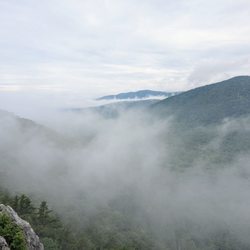
The first and third waterfall from the lower parking area were so pretty. Everything else eh. You should hike to the 3rd waterfall or after the summit turn around and go back the way you came from. If you continue on the loop... omg. 12 + miles , way longer and it's not worth it. Fire trails and so so views of nothing. Bring water and snacks!! http://www.hikingupward.com/SNP/WhiteOakCedarRun/

We hiked from the parking area up to the falls - what a beautiful path! Follows the river the entire route and it was beautiful. As you get across the creek on the rocks, the path gets much trickier and more challenging, so be prepared to really work to get up the hill, but the views are worth it. In all, we hiked about 6 miles round trip because we cam back on the split off of the trail (Cedar Run Link Trail). That really was worthless and added much more distance to the return trip. Unless you want to go over to Cedar Run, it's not worth doing just to get to the parking lot.

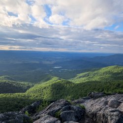
If you are looking for a hike with some waterfalls, the White Oak Canyon trail is a solid and enjoyable hike. The parking lot is off of Skyline Drive. If you only want to hike to the upper falls, it is 4.6 miles to and back with a 1,040 feet elevation change. If you want to continue down, the total hike from the parking lot is 7.3 miles to hike down the canyon to the lower falls with a 2,150 feet elevation change. If you want to hike to the other parking lot at the bottom of the canyon, the round trip is 10 miles. However, a group of hikers that came from that direction told me there was not much to see past the lower falls so I did not add miles on to the hike just to add additional miles for exercise. Parts of the trail have a lot of rocks. As such, be cognizant and watch your step at those parts. There are many falls along the hike. Some falls (e.g. the upper and lower falls) are more obvious than others. You will need to veer slightly off trail to see some of the other ones. The lower falls are definitely the most beautiful of the falls. Without a doubt, I thought they were prettier than the upper falls. In addition, there is a beautiful lookout of the canyon that is about 10 minutes above the lower falls when you are hiking down. I did the hike at the end of August. Unfortunately, the falls can dry up by the end of the summer. From what I read, the falls are at their full glory during the spring or winter. This hike is also good for a fully cloudy or rainy day because there are a lot of trees that provide cover on the trail. Of course, the view of the waterfalls are not impeded without the sun because the trees provide shade of the falls on a sunny day anyway. I also read a lot of warnings about the difficulty of the hike. There is also a sign shortly after the upper falls that warn hikers not to exceed their skill level because there is no shuttle back up to the parking lot. In my opinion, the difficulty of the trail is exaggerated for anyone with a decent amount of hiking experience or in fairly good physical condition. Obviously, you know your own hiking skills. If you do not hike or exercise much, definitely heed those warnings. Nevertheless, I have a couple of alternate routes if you still want to try but are unsure if you can do the main hikes. The steepest parts of the hike are between lower falls and upper falls. If you start from Skyline drive and hike down, you may lose a sense of how steep the hike is. However, you can always start at the bottom and park at the White Oak Canyon Lower Parking Lot at Chad Berry Lane in Syria. You can try to hike up to the upper falls but turn back if the hike becomes too difficult. Obviously, going downhill when you are tired is drastically easier than going up when you are exhausted. If you want to see the lower and upper falls and avoid the steepest parts of the hike altogether, hike to the lower falls from the White Oak Canyon Lower Parking Lot then drive up to parking lot at Skyline Drive and hike to the upper falls. If you are planning a trip to Shenandoah National Park and looking for recommendations, feel free to message me for my itinerary. You can also find the electronic copy through the link my profile.

This is a 1.5 mile out and another 1.5 miles back for a total of 3 miles round trip hike to the lower falls . The hike is not too bad majority is tripping hazards , it has a few spots that get a little steep . As someone who has had double digit knee surgeries I would say it falls in between easy and moderate . Took just under an hour to make it out to the lower 3 falls . Now the trail gets very steep and rough after the 3 lower falls so unless you are in some good shape you might want to just take in the lower falls and call it good . read more


7 months ago
I did the White Oak Canyon - Cedar Run loop yesterday and this trail is perfect for a hot summer day for all ages and abilities! Countless waterfalls (too many to count), tons of opportunities for swimming, cliff jumping and even a water slide! And it's mostly in the shade so the sun isn't as brutal while walking to your destination. I highly recommend that you start at the parking lot at the bottom which does involve a long drive if you are coming from Skyline Drive. However this saves you from having to climb back up to your car when you are tired at the end! The small parking lot fills up quickly so if you are not there by 8-ish, just be prepared to pay $10 for overflow parking at some entrepreneurial neighbors lot. There are two options from the bottom parking lot: the White Oak Canyon trail to the left, the Cedar Run trail to the right. If you have kids and just want an easy hike to the base of a waterfall and a place to swim, I'd recommend the 2 mile hike to Lower White Oak Falls. If you're up for a steeper climb, the Cedar Run Trail takes you to a few swimming holes and a fun water slide about 2 miles from the parking lot. It's possible to do both trails in a loop with a fire road at the top connecting the two. The parks service recommends doing Cedar Run first to get the steep climb out of the way first but I opted to do the White Oak Canyon trail first so I got 2 miles of relatively gradual climb before the climb really picked up. Plus I got the water slide on Cedar Run at the end of the trail to cool off. Either way it's an extremely strenuous hike - about 9 miles and 2400 feet elevation gain. Whatever you choose, it's just bound to be a good time! Just follow some of the tips above so you're not climbing back up 2000 feet back up to your car at the end of the day when you're tired and hungry :) read more


It's the holiday weekend to take advantage of a full day hike. Since its one of the days that the national parks are free, I decided to accomplish one of the trails at Shenandoah National Park. Who doesn't love free? White Oak is about 5 miles round trip but there is also a connecting loop, Cedar run, that turns the total trail to about 9 miles. I always choose the longest trail possible. After driving for almost 3 hours, I almost decided against it but if there's no pain, there's no gain so I stuck with it. White oak has an entrance from Skyline drive or from the bottom of the mountain which is where a lot of reviews recommended to start from. Parking always seem to be an issue so its a good idea to always leave early to snag a spot. Luckily this time parking was not an issue even though I thought arriving near noon was late. While I enjoyed the hike up along the White Oak trail, I did not relish Cedar Run as much. White Oak was wonderful with many scenic points such as waterfalls and overlooks. Although it was steep, it was a breeze compared to the descent on Cedar Run. It is my fault that I did not come readily prepared. At around 5 miles to trek down, it felt forever to complete. Along with frigid temperatures, an icey, treacherous trail, and no mittens like Bernie Sanders for my cold to the bone hands, I wished to turn around. Perseverance is key! Total time to complete was about 6 hours. My legs are still bruised and sore. It looks fun in the summer. Maybe I'll check back then. read more


It's been a couple of years since we last hiked this trail. This time we were staying at a Lodge in nearby Syria and discovered that the trailhead is only 5 miles away so naturally decided to go back despite the weather not being optimal (looked rainy but turned out to be just overcast thankfully). It's one of the most popular trails in the park although not a lot of people on a weekday. Second time around it didn't feel as strenuous as the first time, as we knew what to expect. It's only 1.4 miles to the first (lower) waterfall, so a rewarding short hike if not going further. It's a moderate steady climb mixed with some flat parts, well marked, a bit more rocky surface for first half of the trail, not that difficult if going slowly. The second (upper) waterfall is an additional 1.5 miles with similar but less rocky terrain. Both falls are equally beautiful so if you have the time and energy definitely keep going. This is a scenic hike but no sweeping views at the top - just enjoy the beautiful foliage and the sound and sight of the falls. This trailhead is not at a park entrance but there is a ranger station and entrance/parking fees apply unless you already have a park pass. read more


If you want to go to Shenandoah but don't want to do old rag--this is the perfect trail for you, especially in the summer. Bring your swimsuit bc there's at least 2-3 places you can swim in. There's one particular area where you can go down nature's slide. The water is refreshingly cold, and the slide is scary in my opinion, but worth a try! Just don't have too many people go at once, I think I saw someone almost go over once bc of that. This trail has a lot of incline so be wary and wear footwear that will prevent blisters. The view at the end is...okay to be honest. Since the waterfall is all the way to the right, it is kind of blocked, so really I think the highlight of the trail is mostly getting a great hike in and hiking through waterfalls/jumping into the water. Sadly I can't seem to upload the videos of the water slide but trust me and bring something you can get into the water with (and to dry off)! read more

White Oak - Cedar Run trail - starting from the parking located @ 45 1/2 mile marker is a strenuous hike that is about 8 miles long but after age of 40 it seems to have increased in length. It is one of the top 3 hikes in our region - other two being: Old Rag & Billy Goat), but it is not for everybody. A group of young people started unprepared (bad shoes and not enough water) and their comments varied from, "OMG, look at the beautiful waterfall," at the second one to, "Damn waterfalls!" at 6th waterfall. It is equivalent to climbing 108 stories or 27,000 steps. There is a danger of slipping, even more when your muscles are exhausted. Never the less, come prepared, take the challenge or choose another nearby beautiful hike like "Dark Hollow Falls" that is friendlier. read more


6 years ago
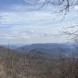
Moderate/ not too difficult hike w GREAT views, definitely worth the effort, highly recommend! read more


This is a great day hike (probably my favorite in the DC area) full of waterfalls, natural water slides, natural springs/streams, and well taken care of trails. I would definitely plan on getting in the water at some point since there are so many opportunities and the water is crystal clear and refreshing. There are 3 separate access points and each has its own parking lot, so if you do not want to hike the entire trail you can just park closest to the destination you are trying to visit (I.e. waterfall, slide, quarry/cliff, etc.). It is dog friendly and the full trail is around 8-9 mi. but a lot of folks just do a portion of the trail. If you are doing the full trail I would park at the bottom of the mountain and not at either of the entrances off of Skyline Drive, just a personal preference. The full trail gives you a little bit of everything, including a fire pass trail connecting the steep incline and declines. There are lots of cascading waterfalls, pools of clear springs, and natural slides tat you can take advantage of. The first waterfall area is usually a bit crowded but if you hike the entire trail you will lose the crowds away from the parking lots. Great hike for any level of hikers and worth the hour and 30 from DC. read more


Very crowded, but you can get your waterfall fix here. Due to the elevation, the greens come late - I visited on a Saturday in late April, and the trees were still rather bare. To avoid the crowds, try going ridiculously early on the weekend, or better yet, visit on a weekday. Note that Skyland Resort is a short walk from the top of the trail, when you get to Skyline Drive. You may be able to find water and/or food there. read more


9 years ago
After the week of rain we had we thought this weekend would be perfect for this hike. Right we were. The river was raging and after the second bridge it followed the trail beside us. We hiked 3.5 miles down to just after the half way sign. Halfway? Yep! It was so adventurous and fun crossing the water and climbing up on the cliff to see the waterfall. There were several and each was so amazing. Water was even coming out of the cliffs like a shower! It's slippery so watch out. The trip back of course was uphill but it really wasn't bad compared to other uphill trails I've been on. Great hike and great scenery after the rains. Enjoy! read more


3 years ago
The first and third waterfall from the lower parking area were so pretty. Everything else eh. You should hike to the 3rd waterfall or after the summit turn around and go back the way you came from. If you continue on the loop... omg. 12 + miles , way longer and it's not worth it. Fire trails and so so views of nothing. Bring water and snacks!! http://www.hikingupward.com/SNP/WhiteOakCedarRun/ read more


4 years ago
11 years ago
We hiked from the parking area up to the falls - what a beautiful path! Follows the river the entire route and it was beautiful. As you get across the creek on the rocks, the path gets much trickier and more challenging, so be prepared to really work to get up the hill, but the views are worth it. In all, we hiked about 6 miles round trip because we cam back on the split off of the trail (Cedar Run Link Trail). That really was worthless and added much more distance to the return trip. Unless you want to go over to Cedar Run, it's not worth doing just to get to the parking lot. read more

9 years ago
If you are looking for a hike with some waterfalls, the White Oak Canyon trail is a solid and enjoyable hike. The parking lot is off of Skyline Drive. If you only want to hike to the upper falls, it is 4.6 miles to and back with a 1,040 feet elevation change. If you want to continue down, the total hike from the parking lot is 7.3 miles to hike down the canyon to the lower falls with a 2,150 feet elevation change. If you want to hike to the other parking lot at the bottom of the canyon, the round trip is 10 miles. However, a group of hikers that came from that direction told me there was not much to see past the lower falls so I did not add miles on to the hike just to add additional miles for exercise. Parts of the trail have a lot of rocks. As such, be cognizant and watch your step at those parts. There are many falls along the hike. Some falls (e.g. the upper and lower falls) are more obvious than others. You will need to veer slightly off trail to see some of the other ones. The lower falls are definitely the most beautiful of the falls. Without a doubt, I thought they were prettier than the upper falls. In addition, there is a beautiful lookout of the canyon that is about 10 minutes above the lower falls when you are hiking down. I did the hike at the end of August. Unfortunately, the falls can dry up by the end of the summer. From what I read, the falls are at their full glory during the spring or winter. This hike is also good for a fully cloudy or rainy day because there are a lot of trees that provide cover on the trail. Of course, the view of the waterfalls are not impeded without the sun because the trees provide shade of the falls on a sunny day anyway. I also read a lot of warnings about the difficulty of the hike. There is also a sign shortly after the upper falls that warn hikers not to exceed their skill level because there is no shuttle back up to the parking lot. In my opinion, the difficulty of the trail is exaggerated for anyone with a decent amount of hiking experience or in fairly good physical condition. Obviously, you know your own hiking skills. If you do not hike or exercise much, definitely heed those warnings. Nevertheless, I have a couple of alternate routes if you still want to try but are unsure if you can do the main hikes. The steepest parts of the hike are between lower falls and upper falls. If you start from Skyline drive and hike down, you may lose a sense of how steep the hike is. However, you can always start at the bottom and park at the White Oak Canyon Lower Parking Lot at Chad Berry Lane in Syria. You can try to hike up to the upper falls but turn back if the hike becomes too difficult. Obviously, going downhill when you are tired is drastically easier than going up when you are exhausted. If you want to see the lower and upper falls and avoid the steepest parts of the hike altogether, hike to the lower falls from the White Oak Canyon Lower Parking Lot then drive up to parking lot at Skyline Drive and hike to the upper falls. If you are planning a trip to Shenandoah National Park and looking for recommendations, feel free to message me for my itinerary. You can also find the electronic copy through the link my profile. read more


9 years ago
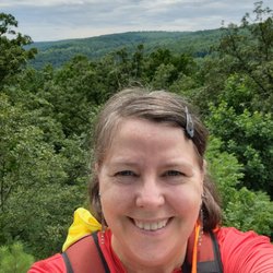
One of my favorite trails by far! The map and trails are not confusing, but I always suggest taking a picture in case anyone gets lost or separated. There are so many routes and loops that you can take, I guarantee an amazing time every time. You can choose to do a short loop and go to the nearest watering hole or you can venture on to finish the entire trail to see all the waterfalls and holes. I would rate the trail moderate, depending on how far you go. read more


7 years ago
9 years ago
11 years ago
Very nice views and not really hard to navigate the white oak side had the pool and the cedar run side had the rock slides. We parked at the bottom and went up its a lot easier than top to bottom. read more


10 years ago
11 years ago
More info about White Oak Canyon Trail
Weakley Hollow Rd
Syria, VA 22743
Directions
(800) 732-0911
Call Now
Hours
Indoor Amenities
Outdoor Amenities
Ask the Community - White Oak Canyon Trail
Review Highlights - White Oak Canyon Trail


Why does Yelp recommend reviews?
White Oak Canyon Trail - hiking - Updated May 2026
Best of Syria
People found White Oak Canyon Trail by searching for…
Hiking Trails With Waterfalls in Syria, Virginia
River Swimming in Syria, Virginia
Things to Do in Syria, Virginia
Cliff Jumping in Syria, Virginia
Scenic Drive in Syria, Virginia
Places to Take Pictures in Syria, Virginia
Scenic Overlook in Syria, Virginia
Scenic View in Syria, Virginia
Running Trails in Syria, Virginia
Lookout Points in Syria, Virginia
Walking Trails in Syria, Virginia
Playgrounds in Syria, Virginia
Dog Friendly Hiking Trails in Syria, Virginia
Off Road Trails in Syria, Virginia
Beautiful Views in Syria, Virginia
Dog Friendly Things to Do in Syria, Virginia
Swimming Lakes in Syria, Virginia
Swimming Holes in Syria, Virginia
Hiking With Kids in Syria, Virginia