Old Rag Mountain Photos


More like Old Rag Mountain
Recommended Reviews - Old Rag Mountain
Start your review...

Reviews With Photos

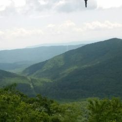
We came to Shenandoah National Park solely to climb Old Rag Mountain. While you definitely have to dedicate your day to this more strenuous, approx 9 mile hike, it was 100% worth it. Planning your hike in advance is necessary because they now use a permit system to gain access to Old Rag. Tickets become available (I believe) 30 days in advance and are a nominal $1/person to reserve. Our hike was on a low-volume day, so we didn't experience any crowding. But I'd imagine this definitely helps reduce congestion on busier days. When getting to Old Rag Mountain, if you're using Google Maps, make sure to put in "Old Rag Mountain Parking" versus "Old Rag Mountain" because maps ended up taking us to a different entrance versus the main entrance for the hike. As I said, this hike is definitely strenuous, but it is still so enjoyable and so worth it. You'll encounter some steep climbs on the way up. While the Rock Scramble is fun (and definitely one of my favorite parts of the hike), it can definitely be tricky to get around at times, and I definitely needed the help of my hiking partners at times to make it up some of the rocks. Getting to the summit was the best experience. You feel above the clouds here, and the view is absolutely incredible and beautiful. We packed a lunch and took the time to just sit and enjoy the magnificence of nature - it was so peaceful and relaxing just looking it out and taking it all in. As I said, it was not crowded while we were there, but everyone up there was speaking quietly if at all, really allowing you to take it all in. You'll have blue trail markers in paint on either the trees or the rocks the whole way, so just make sure to always look for the next blue, and you'll be fine. If you've gone too far and haven't seen a blue in a while, keep in mind you mind have stumbled off the path. Make sure you pack PLENTY of water and food (we brought snacks and a lunch) to keep yourself going on this hike - you will definitely need it. Overall, I've been to 1/3 of the national parks, and this hike sits in my top 3 hikes thus far. If you have the time and energy to devote to it, I completely recommend taking this challenge.


Old Rag is the hike to go to in Shenandoah it will take you at least 5 hours to do. They require reservations and it is only a $1. I recommend going in the morning and during the weekday. The trail can get quite crowded and there is only so much parking and the tickets doesn't guarantee a parking spot. This hike is tough and I don't recommend it for beginners. There are about 4-6 rock scrambles and you are going up a hill. The hike can be anywhere from 7-9 miles and once you get to the summit there are many viewing areas. The hike was clear and clearly marked. This is a must do hike while you are in VA, something for the bucket list.

The ~8.7 mile hike to the peak of Old Rag Mountain was definitely a 5/5 experience. The elevation gain is about 2400 feet, but it's gradual and steady so it didn't make me feel like I'm doing too much all at once. Additionally, the last mile and half is a fun, yet challenging rock scramble, which is not common in nearby trails. Hiking up to the peak requires you to take the Ridge Trail which has icy blue markers on the trees and rocks. To come back down to the parking lot, you can take an easier route - about 2 miles of downhill on a normal looking hiking trail and then 2.5 miles on "Weakley Hollow Fire Road" which has yellow markers on the trees. Definitely bring plenty of water, food, and snacks for this hike. If you're not the best with rock scrambling, definitely go with other people who can pull you up to avoid serious injuries. If possible, make sure to wear shoes with very good grip because some of these rocks are really slippery. I would have fell if I didn't have my friends giving me a boost or pulling me up when I was slipping. Overall, my friends and I had a lot of fun on the trail going up to Old Rag Mountain! There are so many breathtaking photo opportunities throughout the hike, so we stopped a few times to take pictures before we finally made it to the peak. The best part is that there are even better views on the peak, and if you're adventurous, you can climb up the many boulders on top. Because it's regulated by Shenandoah National Park and the government, the trail is paved really well and for the most part, it's pretty safe (the rock scramble is a different story...) However, this also means that there are lots of other groups hiking the trail. So if you're not a fan of seeing a lot of people during your hike, then Old Rag might not be for you. Additionally, you'll need to purchase a National Park Pass to park on the lot. Otherwise, you have to pay a hefty parking fee of $30 or something. Make sure to reserve your tickets (it's like $1 per person) in advance because they do sell out occasionally.

Best hike in Shenandoah NP. Access to trailhead outside the park near Sperryville but there is a fee station and 2 parking lots. Now also need to reserve in advance for $1 per person. We went on a weekday and encountered altogether no more than 2 dozen people on the trail. The loop trail is about 10 miles with the first half being a steep uphill followed by the famous rock scramble and after the summit mostly a fire road down. Newly painted blue blazes so no chance of getting lost. Took us about 6.5 hours at regular pace but we didn't spend a lot of time at the summit. Good workout!

Such a fun though strenuous hike! Old Rag is a 9+ mile trail located about an hour outside of Charlottesville and is part of Shenandoah National Park, so bring your national park pass or prepare to pay a decent parking fee. They have a lot at the trailhead that was only about halfway full when we arrived around 10:30 on a Monday, but could easily see why their overflow lot is needed on the weekend. The early part of the trail is your typical hiking trail over a dirt/rocky uphill path with some steep areas. The real fun starts a couple of miles in when the hike becomes more of a rock scramble, where you'll need to hoist yourself up, lower yourself into, and climb around various rock structures. Since it's more difficult, there can be a bit of back up as people figure out how to get past certain tricky spots, but things were smooth for us with the smaller weekday crowd. At the top (and several points along the way), you're rewarded with an incredible view of the mountains. The trail back down is fairly similar to the earlier part of the trail --- no more rock scrambling, just a dirt pathway. There is a shelter that includes a privy along that second half of the journey if nature calls. Several miles of the trek back are over the fire road, which is a less exciting gravel road that I was honestly grateful for since it was easier for tired legs. The last mile of the trail is uphill since they have moved the trailhead in the past few years, so mentally prepare yourself for one last burst of cardio.

Definitely not for the faint of heart. I've hiked Old Rag a few times times with friends and family, and each time feels like the first time. There's lots of rock scrambling and amazing views. For a 9.5 - 10 mile hike, ensure that you have snacks to refuel. It feels very rewarding, yet calming to eat lunch on one of the false summits. I would not try this hike with kids, so leave them home. Grab your girl and/or guy friends, and get to hiking!

I still love this trail, even though a few things have changed that is annoying: - you need a permit per person, so you have to sign up in advance and pay $1 - there's more parking, but that also means a lot of people...but I guess that's what the permit system is for - there's a mile added for those entering from the new parking lot entrance - the trail can get traffic-y for the harder rock scramble parts There are at least 4-6 parts where you'll have to climb slightly, so be on your rock scramble and climbing game and have good grippy shoes! Even without the "climbing" parts, there's still a ton of rock scrambles so definitely wear good shows and be in that rock scramble mindset. The summit/top in my opinion isn't the best view. It's the parts where it's mostly rock. Just stop and eat your snack and enjoy the view when you feel like you're high enough with a good view. Going down is and feels longer than the time going up. So don't give up bc the way down is super easy but super long. Last, def bring a first aid kit just in case. I've seen 6 people injured on this trail (total) and it's worth bringing.

Hiked Old Rag today - and let me just start off by saying, Shenandoah in the autumn season is simply breathtaking. This was my first time hiking Old Rag, and I would say that it definitely is one of the top hikes I have done thus far because of the variety of challenges. As many others have done, I pored over blogs prior to going, and was a bit anxious about the difficulty level during the rock scrambles; however - it ended up more fun than anything. I hope that this review will quell some anxieties and make it more straightforward! Fair warning, as previously mentioned, it is a popular hike and does get quite busy if you end up coming here anytime past 7:30/8A, especially on weekends. HIKE: - Overall difficulty: moderate during the ascent; mild-moderately challenging during the rock scrambles/bouldering. - My Strava app logged a total of 10.6 miles round trip, however the official Shenandoah maps report 8.8 miles. - You hike in a clockwise fashion, with some switchbacks in the first 4 miles. - You ascend approximately 2,500 ft in the first 4 miles up till the summit. - Follow the blue blazes along the trail closely. They are clearly demarcated, though the more adventurous spirits may also find beautiful vistas on roads less travelled (we accidentally found a false summit). There are several of flatter, rest spots along the way up with vistas should you like to take water break or refuel. - You start the scramble around mile 2.8, and continue until mile 4 (summit). Contrary to most reviews, being vertically challenged (me!) doesn't necessarily mean it will be harder - you just have to be more aware of your available holds and environment. Also, you don't need a whole lot of upper body strength; again, just being smart with your environment. With that being said, very small children may need assistance from the vertical descent of at one point featuring a drop of approximately 6 ft. - You end by descending down a fire road on Weakley Hollow (gravel, rocks). It's gorgeous in its own right, and ends up by a picturesque running stream. - The official park map suggests you to go back up the Ridge Trail for an additional ~1.2 miles to ultimately end at the parking lot. My sister and I just crossed the second chain link fence with many other hikers onto Nethers Road (~0.4 miles) to end at the parking lot. PARKING: - Parking at Old Rag fills up early! The official lot near the trail head was almost full when we arrived at 6:50AM. It is free! - To find the parking lot, type in: "Old Rag Mountain Fee and Information Station" in Google maps. It is located on Nethers Road. - There is an overflow lot approximately 0.8 miles east of the trailhead. - Some private houses will allow parking on their land for fees $10-20. FEES: - Visitors are expected to have a park pass (day, Shenandoah, Interagency). When we arrived at 6:50A, I was surprised that the fee station was already open and people lining up to purchase passes. If you already have a pass, you also line up to "report" how many people are in your party and to show them your pass. It's pretty quick. - As mentioned, parking in the official lot is free. AMENITIES: - There is 1 porta potty in the official Old Rag lot, and two more park toilets (like a porta potty but just with brick walls, honestly). They are located near the fee station, close to trail head. - No running water to wash hands, so bring hand sanitizer. ADVICE: - Get here early not only for prime parking, but also to avoid bottle necks at the scramble. (My friend had hiked the day prior and just by starting off around 8A, there was point in time where he waited 50 minutes for a portion of the scramble...!!!). Luckily, we began our hike around 7A and had essentially no bottle necking frustrations. - Hiking shoes with traction are recommended, but my sister hiked in her regular Nike running shoes. There were some parts that were slippery, but she made it just fine. - Most folks are hiking clockwise, though we did see some hikers coming up from the counterclockwise direction. I wasn't there to see it personally, but I imagine that this also adds to the bottle necking effect later during the day. - If coming in from out of town, I recommend staying in Culpeper, VA - it is 30 minutes from the trailhead. (The road is pitch dark in the morning, but just drive slowly and load your GPS beforehand as you WILL lose service!) - Bring plenty of water, snacks, and sun protection. If hiking during fall, dress in layers. PERSONAL STATS: My sister and I completed the hike in 3.5 hours total, with 15-20 minutes of rest time at the top of the summit to enjoy snacks, view, and of course, indulge in photos! Overall, I would highly recommend this trail for those wanting a bit of adventure! Have fun and stay safe!


Hiking Old Rag on a 95 degree day make sure to bring ample water. The hike was challenging, but not undoable. If this is your first hike with rock scramble, it may not be for you. But if you have experience, this is a great hike. We did the circuit, which is 9.4 miles round trip. The way up, had a steady incline. Pretty easy for the first 2.5-3 miles. Keep in mind, you are still climbing a mountain! Once you get to the rock scramble, for someone who is 5'0 I found some parts challenging since there was nothing to grip on some parts and the step up was way above my waist. I had to have my husband give me a boost in two spots, while I flung forward to grab on to something and hope that I didn't fall. Luckily In each place I was able to use my upper body to pull myself up. Also, don't bypass the comments about bringing gloves like we did. Our hands were pretty sore/tore up after the rock scramble. You are using your whole body to get up on these boulders. The rocks are very jagged and pointy, not smooth like we have experienced on other hikes. All together it was a great hike with great views.

I've hiked this mountain twice. This isn't the easiest hike in the world but it is fairly challenging going up. The first time I completed the whole hike but this time I am pregnant so I did about 6 miles total! Really pretty views and plenty of spots to pull off if a group is too close or if you need to take a breather. Be sure to prepare with snacks and water for your trip and leave optimal amount of time before it gets dark!

3 months ago


I've been wanting to tackle the Old Rag hike for quite some time. My friends from Outdoor Afro organized a group hike. I couldn't resist! We began our hike at 0930. I've gotta say, I was surprised at our starting location. I didn't have to drive through the 'booth' and pay to actually enter the park. That was weird to me, but our hike leader explained that, during the busy season, rangers are on site to check for passes. So.... I assume you'd have to purchase a pass online and place it on your dashboard. I'm a Veteran so I have that pass so I couldn't tell you how that works. Right off the bat you're climbing. No easing into your hike, you're THERE, at elevation. Of course, the higher you climb the mountain the more elevation you gain, but at the start you're already gaining. There are a lot of false summits. You think you've made it to the top, but you're not there yet! Ha! Because it was January, the trees were barren, so I could see the vastness of the forest. There was a bit of ice, but nothing that impeded our climb. I had always planned to do the hike in fall, to see the colors, but this was great as well. It was a perfect day. And then there's the rock scramble-----AMAZING! I loved climbing over, under, and through the rocks. There are times you have to jump over a small gap or squeeze between rocks, but I was down for it all! I was on the trip with people who had done the hike before so that helped in a few situations where I could have gotten lost or didn't quite know how to get over a rock. Once we finally made it to the actual peak, the view was amazing! The entire hike was awesome! Some of the rock placements, like, how does a rock just sit in a certain spot, have you wondering HOW. It's that 'Awe' factor. We had some slower hikers and we didn't want to leave anybody behind. So, that brought us to the point where we were coming down in the dark. Luckily, I had my head lamp and so did many others. A quick note to be prepared for anything. Those worst case scenarios are possible. It's a GREAT hike and I'll definitely do it again with ONLY seasoned hikers. read more


Such a hard hike if you do the loop but so rewarding! If you do the loop - 9.7 miles - it's roughly 4.5 - 6 hours depending on how fast you're going. Lots of rock scrambling on the first half and then downhill the rest. I would not do this unless you have at least 2-3 water bottles per person. $30 for a national park day pass and you need to buy the $2 per person old Rag pass before hiking. Do it the day before - there's no service in the area. Also no food or potable water. So be aware, you need to bring snacks and plenty of water with you. read more


1 month ago
We came to Shenandoah National Park solely to climb Old Rag Mountain. While you definitely have to dedicate your day to this more strenuous, approx 9 mile hike, it was 100% worth it. Planning your hike in advance is necessary because they now use a permit system to gain access to Old Rag. Tickets become available (I believe) 30 days in advance and are a nominal $1/person to reserve. Our hike was on a low-volume day, so we didn't experience any crowding. But I'd imagine this definitely helps reduce congestion on busier days. When getting to Old Rag Mountain, if you're using Google Maps, make sure to put in "Old Rag Mountain Parking" versus "Old Rag Mountain" because maps ended up taking us to a different entrance versus the main entrance for the hike. As I said, this hike is definitely strenuous, but it is still so enjoyable and so worth it. You'll encounter some steep climbs on the way up. While the Rock Scramble is fun (and definitely one of my favorite parts of the hike), it can definitely be tricky to get around at times, and I definitely needed the help of my hiking partners at times to make it up some of the rocks. Getting to the summit was the best experience. You feel above the clouds here, and the view is absolutely incredible and beautiful. We packed a lunch and took the time to just sit and enjoy the magnificence of nature - it was so peaceful and relaxing just looking it out and taking it all in. As I said, it was not crowded while we were there, but everyone up there was speaking quietly if at all, really allowing you to take it all in. You'll have blue trail markers in paint on either the trees or the rocks the whole way, so just make sure to always look for the next blue, and you'll be fine. If you've gone too far and haven't seen a blue in a while, keep in mind you mind have stumbled off the path. Make sure you pack PLENTY of water and food (we brought snacks and a lunch) to keep yourself going on this hike - you will definitely need it. Overall, I've been to 1/3 of the national parks, and this hike sits in my top 3 hikes thus far. If you have the time and energy to devote to it, I completely recommend taking this challenge. read more


2 years ago
Loved hiking Old rag. Intense but worth it. Rick scramble gives it an elevated challenge. Views at the top of the mountain are insanely beautiful read more


Old Rag is the hike to go to in Shenandoah it will take you at least 5 hours to do. They require reservations and it is only a $1. I recommend going in the morning and during the weekday. The trail can get quite crowded and there is only so much parking and the tickets doesn't guarantee a parking spot. This hike is tough and I don't recommend it for beginners. There are about 4-6 rock scrambles and you are going up a hill. The hike can be anywhere from 7-9 miles and once you get to the summit there are many viewing areas. The hike was clear and clearly marked. This is a must do hike while you are in VA, something for the bucket list. read more


The ~8.7 mile hike to the peak of Old Rag Mountain was definitely a 5/5 experience. The elevation gain is about 2400 feet, but it's gradual and steady so it didn't make me feel like I'm doing too much all at once. Additionally, the last mile and half is a fun, yet challenging rock scramble, which is not common in nearby trails. Hiking up to the peak requires you to take the Ridge Trail which has icy blue markers on the trees and rocks. To come back down to the parking lot, you can take an easier route - about 2 miles of downhill on a normal looking hiking trail and then 2.5 miles on "Weakley Hollow Fire Road" which has yellow markers on the trees. Definitely bring plenty of water, food, and snacks for this hike. If you're not the best with rock scrambling, definitely go with other people who can pull you up to avoid serious injuries. If possible, make sure to wear shoes with very good grip because some of these rocks are really slippery. I would have fell if I didn't have my friends giving me a boost or pulling me up when I was slipping. Overall, my friends and I had a lot of fun on the trail going up to Old Rag Mountain! There are so many breathtaking photo opportunities throughout the hike, so we stopped a few times to take pictures before we finally made it to the peak. The best part is that there are even better views on the peak, and if you're adventurous, you can climb up the many boulders on top. Because it's regulated by Shenandoah National Park and the government, the trail is paved really well and for the most part, it's pretty safe (the rock scramble is a different story...) However, this also means that there are lots of other groups hiking the trail. So if you're not a fan of seeing a lot of people during your hike, then Old Rag might not be for you. Additionally, you'll need to purchase a National Park Pass to park on the lot. Otherwise, you have to pay a hefty parking fee of $30 or something. Make sure to reserve your tickets (it's like $1 per person) in advance because they do sell out occasionally. read more


Best hike in Shenandoah NP. Access to trailhead outside the park near Sperryville but there is a fee station and 2 parking lots. Now also need to reserve in advance for $1 per person. We went on a weekday and encountered altogether no more than 2 dozen people on the trail. The loop trail is about 10 miles with the first half being a steep uphill followed by the famous rock scramble and after the summit mostly a fire road down. Newly painted blue blazes so no chance of getting lost. Took us about 6.5 hours at regular pace but we didn't spend a lot of time at the summit. Good workout! read more


Such a fun though strenuous hike! Old Rag is a 9+ mile trail located about an hour outside of Charlottesville and is part of Shenandoah National Park, so bring your national park pass or prepare to pay a decent parking fee. They have a lot at the trailhead that was only about halfway full when we arrived around 10:30 on a Monday, but could easily see why their overflow lot is needed on the weekend. The early part of the trail is your typical hiking trail over a dirt/rocky uphill path with some steep areas. The real fun starts a couple of miles in when the hike becomes more of a rock scramble, where you'll need to hoist yourself up, lower yourself into, and climb around various rock structures. Since it's more difficult, there can be a bit of back up as people figure out how to get past certain tricky spots, but things were smooth for us with the smaller weekday crowd. At the top (and several points along the way), you're rewarded with an incredible view of the mountains. The trail back down is fairly similar to the earlier part of the trail --- no more rock scrambling, just a dirt pathway. There is a shelter that includes a privy along that second half of the journey if nature calls. Several miles of the trek back are over the fire road, which is a less exciting gravel road that I was honestly grateful for since it was easier for tired legs. The last mile of the trail is uphill since they have moved the trailhead in the past few years, so mentally prepare yourself for one last burst of cardio. read more


6 years ago
Definitely not for the faint of heart. I've hiked Old Rag a few times times with friends and family, and each time feels like the first time. There's lots of rock scrambling and amazing views. For a 9.5 - 10 mile hike, ensure that you have snacks to refuel. It feels very rewarding, yet calming to eat lunch on one of the false summits. I would not try this hike with kids, so leave them home. Grab your girl and/or guy friends, and get to hiking! read more


I still love this trail, even though a few things have changed that is annoying: - you need a permit per person, so you have to sign up in advance and pay $1 - there's more parking, but that also means a lot of people...but I guess that's what the permit system is for - there's a mile added for those entering from the new parking lot entrance - the trail can get traffic-y for the harder rock scramble parts There are at least 4-6 parts where you'll have to climb slightly, so be on your rock scramble and climbing game and have good grippy shoes! Even without the "climbing" parts, there's still a ton of rock scrambles so definitely wear good shows and be in that rock scramble mindset. The summit/top in my opinion isn't the best view. It's the parts where it's mostly rock. Just stop and eat your snack and enjoy the view when you feel like you're high enough with a good view. Going down is and feels longer than the time going up. So don't give up bc the way down is super easy but super long. Last, def bring a first aid kit just in case. I've seen 6 people injured on this trail (total) and it's worth bringing. read more


Hiked Old Rag today - and let me just start off by saying, Shenandoah in the autumn season is simply breathtaking. This was my first time hiking Old Rag, and I would say that it definitely is one of the top hikes I have done thus far because of the variety of challenges. As many others have done, I pored over blogs prior to going, and was a bit anxious about the difficulty level during the rock scrambles; however - it ended up more fun than anything. I hope that this review will quell some anxieties and make it more straightforward! Fair warning, as previously mentioned, it is a popular hike and does get quite busy if you end up coming here anytime past 7:30/8A, especially on weekends. HIKE: - Overall difficulty: moderate during the ascent; mild-moderately challenging during the rock scrambles/bouldering. - My Strava app logged a total of 10.6 miles round trip, however the official Shenandoah maps report 8.8 miles. - You hike in a clockwise fashion, with some switchbacks in the first 4 miles. - You ascend approximately 2,500 ft in the first 4 miles up till the summit. - Follow the blue blazes along the trail closely. They are clearly demarcated, though the more adventurous spirits may also find beautiful vistas on roads less travelled (we accidentally found a false summit). There are several of flatter, rest spots along the way up with vistas should you like to take water break or refuel. - You start the scramble around mile 2.8, and continue until mile 4 (summit). Contrary to most reviews, being vertically challenged (me!) doesn't necessarily mean it will be harder - you just have to be more aware of your available holds and environment. Also, you don't need a whole lot of upper body strength; again, just being smart with your environment. With that being said, very small children may need assistance from the vertical descent of at one point featuring a drop of approximately 6 ft. - You end by descending down a fire road on Weakley Hollow (gravel, rocks). It's gorgeous in its own right, and ends up by a picturesque running stream. - The official park map suggests you to go back up the Ridge Trail for an additional ~1.2 miles to ultimately end at the parking lot. My sister and I just crossed the second chain link fence with many other hikers onto Nethers Road (~0.4 miles) to end at the parking lot. PARKING: - Parking at Old Rag fills up early! The official lot near the trail head was almost full when we arrived at 6:50AM. It is free! - To find the parking lot, type in: "Old Rag Mountain Fee and Information Station" in Google maps. It is located on Nethers Road. - There is an overflow lot approximately 0.8 miles east of the trailhead. - Some private houses will allow parking on their land for fees $10-20. FEES: - Visitors are expected to have a park pass (day, Shenandoah, Interagency). When we arrived at 6:50A, I was surprised that the fee station was already open and people lining up to purchase passes. If you already have a pass, you also line up to "report" how many people are in your party and to show them your pass. It's pretty quick. - As mentioned, parking in the official lot is free. AMENITIES: - There is 1 porta potty in the official Old Rag lot, and two more park toilets (like a porta potty but just with brick walls, honestly). They are located near the fee station, close to trail head. - No running water to wash hands, so bring hand sanitizer. ADVICE: - Get here early not only for prime parking, but also to avoid bottle necks at the scramble. (My friend had hiked the day prior and just by starting off around 8A, there was point in time where he waited 50 minutes for a portion of the scramble...!!!). Luckily, we began our hike around 7A and had essentially no bottle necking frustrations. - Hiking shoes with traction are recommended, but my sister hiked in her regular Nike running shoes. There were some parts that were slippery, but she made it just fine. - Most folks are hiking clockwise, though we did see some hikers coming up from the counterclockwise direction. I wasn't there to see it personally, but I imagine that this also adds to the bottle necking effect later during the day. - If coming in from out of town, I recommend staying in Culpeper, VA - it is 30 minutes from the trailhead. (The road is pitch dark in the morning, but just drive slowly and load your GPS beforehand as you WILL lose service!) - Bring plenty of water, snacks, and sun protection. If hiking during fall, dress in layers. PERSONAL STATS: My sister and I completed the hike in 3.5 hours total, with 15-20 minutes of rest time at the top of the summit to enjoy snacks, view, and of course, indulge in photos! Overall, I would highly recommend this trail for those wanting a bit of adventure! Have fun and stay safe! read more

Yes!!! Perfect hike! About ten miles round trip. The rock scrambles are about a 1-1.5 miles long. Definitely for intermediate hikers as there are parts where you have to climb up and down rocks. Started at 6:45a, finished by 11:45a. Don't forget to bring some snacks for lunch! read more


3 years ago


Hiking Old Rag on a 95 degree day make sure to bring ample water. The hike was challenging, but not undoable. If this is your first hike with rock scramble, it may not be for you. But if you have experience, this is a great hike. We did the circuit, which is 9.4 miles round trip. The way up, had a steady incline. Pretty easy for the first 2.5-3 miles. Keep in mind, you are still climbing a mountain! Once you get to the rock scramble, for someone who is 5'0 I found some parts challenging since there was nothing to grip on some parts and the step up was way above my waist. I had to have my husband give me a boost in two spots, while I flung forward to grab on to something and hope that I didn't fall. Luckily In each place I was able to use my upper body to pull myself up. Also, don't bypass the comments about bringing gloves like we did. Our hands were pretty sore/tore up after the rock scramble. You are using your whole body to get up on these boulders. The rocks are very jagged and pointy, not smooth like we have experienced on other hikes. All together it was a great hike with great views. read more


I've hiked this mountain twice. This isn't the easiest hike in the world but it is fairly challenging going up. The first time I completed the whole hike but this time I am pregnant so I did about 6 miles total! Really pretty views and plenty of spots to pull off if a group is too close or if you need to take a breather. Be sure to prepare with snacks and water for your trip and leave optimal amount of time before it gets dark! read more


An INCREDIBLE hike, but this is definitely one for an experienced hiker. I wouldn't recommend it for children under 12 because of the length and intensity. It features a very challenging rock scramble and an intense uphill climb. There are several beautiful/scenic overlooks, but nothing beats the view from the summit. Pack a lunch to enjoy at the top! You'll need the break and some fuel to help get you back down. I recommend starting around 7am, depending on your pace and amount of breaks, the hike can take 5-8 hours starting and ending from the parking lot. read more


==Quick Notes== Trail circuit: 8.8 miles - Ridge Trail (rocky switchbacks, rock scramble) - Saddle Trail (rocky switchbacks) - Weakley Hollow Fire Road (gravel, some rocky patches) **Saw a bear on the Fire Road** Roundtrip time: 7.5 hrs (with lots of breaks, lunch, and pictures) Rigor: Strenuous Parking: medium, earthy official lot with park rangers Special clothing: shoes with ankle support, gloves ==The Experience== I'm not one to leave Yelp review for trails, but there's a lot to say about this trail that it would be helpful leaving some brief tips. We got there around 8AM on a Saturday (summer time) and maybe 1 and a half rows of the parking lot were taken, which is about 1/3 of the whole lot. I'll preface and say that I'm out of shape and hadn't worked out in awhile when I did this hike. The rock scramble scared me since I'd never done it before and other people said that you'd have to be able to pull yourself up in places...needless to say, I did it (with some help). The hardest part was actually having enough endurance for the entire hike, but the scramble was actually one of my favorite parts! It made hiking feel more adventurous! I HIGHLY recommend doing the Ridge trail first since it's rocky and includes the rock scramble. The Saddle Trail and Weakley Hollow Fire Road on the way down were longer, but manageable for my fatigued legs. Both the Ridge trail and Saddle Trail are rocky with switchbacks. The rock scramble is going over large rock slabs, between boulders, and occasionally lifting your weight to get on top of rocks. I might have been the only one who wore gloves, but it saved my hands and helped me grip some spots better. I scraped my knees only a little and it was a cool enough day that I could have worn pants to cover them. I will say what I needed the most help was getting my foot in the right spot, particularly if it was a bit of a leap since my legs are short. I have to thank my friend for helping me in these spots by pushing me to give me a slight boost, but I did most of it on my own. During the rock scramble there's multiple places to take some gorgeous photos of the view. There's also a few 'false summit' spots that are perfect for eating lunch at. Some people actually turned around at this point without realizing they didn't get to the actual summit! The real summit has wooden signs and some marked off areas for protecting vegetation, so don't get confused! We didn't get to see the view since it was a foggy day, but it made for some cool photos. On the way back was challenging because of the fatigue. My feet weren't kicking up as high, so getting over those rocks on the Saddle Trail posed an issue (I just went slower than before). Hiking poles could have been useful, but you'll have to put those away if you went on the rock scrambling part. The fire road seems really long after all those exciting switchbacks and the rocky terrain at the summit. It might have been perfect cool, summer weather for this, but we saw a BEAR on the trail back! Luckily it was just crossing and other people were around, but just keep your eyes open. Took me 7.5 hrs (from the parking lot) because I hike at a very slow pace, took lots of photo breaks, ate lunch at the top, and did the circuit with the fire road. I think everyone else can do it in less time, so think of my experience as the maximum amount of time needed. Enjoy the rock scramble and the view, but most of all, have fun! read more


9 years ago
One of the many hikes in Shenandoah National Park--my favorite hike of all time so far.... * Challenging rock scramble (there's a safety video on the website) * Difficult uphill at the beginning, equally interesting downhill on the way back down from the summit * Amazinnggg view at the summit * Can get crowded if you don't go early--especially at certain rock scramble bottleneck points * Beautiful in the fall, but smells amazing with tons of tiny flowers in the spring * Only a couple of portapotties available * National Park Pass valid here, otherwise $8 fee per person Useful Links: http://www.hikingupward.com/SNP/OldRag/ http://www.nps.gov/shen/planyourvisit/upload/old_rag_area.pdf [Map from NPS] read more


It's been said before, and I'll say it again. This trail is HARD! Probably one of the hardest hikes I've ever done - yet so so so fun!! I will point out, up front - this isn't a knee-trembling dangerous hike where there's fear you'll fall off a rock and plummet to your death; this is a straight-up-physically demanding and absolutely challenging hike! Which, I must say, not constantly worrying about falling to your death is a really nice way to hike! Probably one of my favorite hikes to date as well, and keep it mind - it was about 29 degrees and SUPER windy the entire time we did this 5 hour trek! *We made it back in 5 hours and 10 minutes, so we're going ahead and rounding down here. The hike itself claims to be about 9 miles, which feels right, I might venture to say it was longer because all the scurrying around I had to do in order to reach things! The elevation change is 2,380 feet, which is super exciting - there are a couple 'false summits' where there's an amazing view, and you THINK you've reached the top, but there's a LONG way to go! NPS website boasts that Old Rag is Shenandoah's "most popular and most dangerous hike" and alludes to the number of search and rescue missions each year. "Strenuous rock scramble that requires good upper body strength" is the big attraction here. The website even mentions that children or "shorter adults" might need "assistance navigating the scramble" .....*raises hand* In reality, had I not been hiking with my 6ft husband, I'm not sure I would have made it to the top. At 5-foot-nothing, I struggled to reach handholds, ledges, and footings. I remember vividly a point at which my husband literally had to drag me up a rock because I couldn't reach the grab. I say all this, and still would recommend the hike! It was very good that we didn't know how difficult it truly was going up - because we might have turned around! One of the major problems we encountered was ice on the rocks - water that had started to melt in the sun earlier in the day, had turned back into ice - making some of our steps pretty precarious, even with sturdy *purple* hiking boots. We each wore hiking backpacks - storing our 2 liters of water (which, yes we almost finished), gloves, headlamps, camera, tripod, and plenty of granola bars. In hindsight - the packs made the hike a little more difficult - there were some bits where we actually had to take them off and pass them through, in order to fit in opening in the rocks. There were a good number of hikers on the trail as we made our way, but for a majority of the hike we were on our own - we started our hike at Noon on Friday (Veterans Day, actually) and made it back to the parking lot by 5:10 PM - and it was almost dusk! The headlamps were absolutely a must-have because had we taken any longer, we would have needed them! read more


 - Hiking Near Me")
 - Hiking Near Me")
 - Hiking Near Me")
 - Hiking Near Me")

 - Hiking Near Me")
This mountain is one of those things you should try at least once in your life. If you're a hiker, you'll love this. The challenge is to get to the rock scramble because that's the best part. Quite dangerous if you move too quick and aren't aware of your surroundings but otherwise, it's great. It'll take probably somewhere between 5-6 hours from the time you park a mile away from the beginning of the trail. Prepare to sweat a lot during the first mile or two on the trail, don't forget to go off the trail a little and see the beautiful mountains. Take lots of water!! They recommend about 2liters per person. Also, if it's too hot, it may not be a good idea to go unless you want to drown in your own sweat. :) Don't forget to stretch and wear good traction sneakers, it can be slippery. Lunch- prepare a healthy sandwich, fruit or nuts. Take lots of pictures and have fun! :) read more

10 years ago
A fantastic, challenging, and fun hike with amazing views! A lot has already been said about Old Rag Trail, but I'll just throw in my 2 cents anyways. First, I recommend coming here on a week day if possible. I came on a Monday, and saw less than a dozen people on my way up, and less than a dozen on my way down as well. I have heard that the crowds can be bad on the weekend, so I'm glad that I chose to come on a week day. Speaking of crowds, the park ranger at the gate highly encouraged me to go up the blue-blaze trail (up the rock scramble first), then down via the yellow trail (Weakly Hollow Fire Trail). I think this is to help make the rock scramble portion a one-way path versus struggling to have people going in both directions during the narrow portions. While I am in full support of this, I thought the Fire Trail was rather boring (it is all downhill so no complaints about that), and I would rather go back up the rock scramble and back the same way I came. I would only do this on a weekday when it's not crowded though. It was gorgeous (but humid and hot) in the middle of July, but I'd love to come back in the fall to see those gorgeous fall colors. Finally, like others have said, bring lots of water and snacks! Took me a little under 5 hours for the entire circuit (11.5 miles measured on my phone GPS...accounts for walking to/from the trailhead, getting lost, walking extra to see some good views at the lookouts, etc.) Enjoy!! read more


4 years ago
8 years ago
You would think that trekking in the Himalaya Mountains would keep me in great shape, but Old Rag showed me who is boss on a hot, sweltering summer day in Shenandoah National Park. The Old Rag trail hike was exciting and fun. The hike challenge my fitness and conditioning. It taught me a valuable lesson that I should always take enough water on my adventures. I had finished my bottle of water before I got to Trails head. Oh Boy! The views were scenic. The rock scrambles were fun to climb on & over. I was surprise at the amount of wildlife that I encountered. read more


8 years ago
Challenging? Yes. Worth it? Most definitely! 10/10 would hike Old Rag again. I will say, bring plenty of water! Plan on taking on some obstacles too. Rock scrambles , switchbacks, army crawling your way up one too! Needless to say once you reach the top and see the incredible views, you'll be proud of what you just accomplished, just like how I felt. I can't wait to go back! read more


Love this mountain. I can usually do it in 4-6 hours. Don't forget toilet paper. Also bring cash money because sometimes there's a park ranger collecting a $15 fee. But also sometimes he's absent from duty. Also take someone who's in the military to have that fee waived. Lots of rocks. Old rag rocks! Also on the drive back love stopping in Warrenton at Black Bear Bistro and ordering the wrong thing. read more


Oh my word. This was my first time hiking, but my friends assured me I would be fine. Well let me tell you, it was definitely quite the challenge, but soo worth it. The circuit hike is a total of 9mi, around half up and half down. The scenery is beautiful with multiple false summits along the way that make for great photo ops. The rock scramble is super fun and was my favorite part of the hike (aside from the summit, of course). We described it as being like an adult playground since you can get as creative as you want when climbing. I did need some assistance at some of the larger rocks, just because my shoes didn't have that much grip and I wasn't tall enough to reach the top. We reached the main summit just in time to watch the sunset. It was so peaceful and really put things into perspective. With the light dwindling, we made sure to make it past the rocks and onto the dirt path before it got pitch black. The rangers at the parking lot were worried for us before our hike since we started so late and didn't have headlamps, but the flashlights on our phones actually worked really well. If you're out that late, make sure you take a moment to just look up at the stars. We spotted a few shooting stars which made for the perfect ending to our hike. Overall, there's a reason this hike is considered one of the best in the US. Go out and enjoy! read more


9 years ago
Things you will need: 7ish hours of daylight, water, shoes with very good tread, camera, protein, clothes that you don't mind scraping against rocks and can crouch down in while everyone stares at your butt from below. Next day feeling...like I did a large amount of squats and push-ups. Hiking and climbing to the summit of Old Rag is an accomplishment. (You will be doing both!) You will get to a boulder crevice and wonder..."what am I supposed to do here?" Depending on you size, age, and endurance everyone runs into different challenges. I had no trouble walking uphill for 3 miles but I found that navigating through the rock scramble was tricky... and amazing. read more


Old rag is a 9+ mile circuit hike plus ~1.5 mile walk roundtrip from the parking lot. We arrived at 830am on Saturday and the parking space was filling up but still with plenty of spots. There's portable bathrooms near the lot before you start on your hike. Make sure to pay your entrance fee ($25/vehicle; pass is good for a whole week). We decided to take the hike counter clockwise. Walking uphill was the hardest part of the trail. The rock scramble was a lot of fun, though a little bit challenging for a shortie like me (I'm 5'2"). Wearing climbing gloves is not a bad idea; though none of us had any and still got through pretty much injury free. There's a part where you have to bend down to pass through a rocky tunnel. There's a couple false summits (that, honestly, had better views). You'll know when you hit the summit; there'll be a sign! The hike down was pretty easy; we didn't make any rest stops. Once you get through the trees, there's a bathroom and ~2.5 mile hike on an unpaved horse trail to get back to the trailhead (and then the 0.8 mile hike back to the parking lot). The hike in total took 5 hours, though we did take a couple breaks on the way up and a longer lunch break near the top. We packed ~2.5 L of water for the three of us. I would suggest packing more, especially if it's sunny out. Fortunately, it was cloudy and 50-70 degrees when we went so it was a very comfortable hike. Definitely bring lunch and snacks! I would highly recommend wearing hiking boots- they have better grip for the scramble and help protect your ankles! read more


5 years ago
This was an awesome yet strenuous hike! We hadn't hiked in a while and knew we were a little out of shape so starting out we were doubting our abilities but we pushed on and are SO glad we did! It was so worth it and an awesome accomplishment for my 4 boys, my husband and I. I recommend 2liters of water or 4 water bottles for this day hike, it's @7hrs total. They have an overflow parking area you'll see first, drive on down to the nearest one to be right at the trail head, otherwise you'll have an extra hike distance. Pack light, small bag if at all possible with just the water you need and some snacks. The rock scramble was hands down the most challenging and fun of the trip with incredibly rewarding views! Some gloves for the rocks are recommended. You'll want the small bag due to that part, some spots are tight squeezes. Be prepared to jump from large rock to rock in places just before the summit. I don't recommend this trail if it's rainy, it could become way to slippery. Walking sticks are awesome only on the way down so if you have a retractable type that you could strap to your backpack would be the best. read more


Old Rag is my idea of a perfect introductory trail towards "real" hiking. The 8.8 mile circuit is difficult for beginners but even at its most challenging spots it is still relatively safe. It offers breathtaking views and a solid workout. Although there will likely be lots of other people around on a weekend, there won't be hand rails, paved paths, armed rangers enforcing the boundaries, etc. One of the coolest aspects of Old Rag is its ability to scale up your adventure. If you want to try something challenging, there's plenty of rocks and scary things around to climb on (and no one to yell at you for doing so). The views from even the easy-to-reach areas are spectacular but they tempt hikers to expand their limits just a bit as well. "Would this view be cooler from atop that boulder? Maybe... it's not -that- big. I'll scramble up and check it out." That's what can go through your head! There's plenty of spots that even an experienced climber would be insane to try, so the difficulty is plenty scalable. Old Rag is a great hike for any mixed group or lone novice adventurer. Just be warned: there is a small bit of climbing, so if you're extremely frail or really fat, this hike is probably too intense for you. read more


8 years ago
7 hours total for this hike! Lots of climbing/bouldering and sweats for amazing views. Make sure to bring enough water to drink and some good snacks! Wear long pants if you don't want your legs to get scraped up. The way up was difficult but the way down was tough on the knees. It was a sunny day so it made life easier. I can't imagine what it would be on a rainy day! The rocks would be too slippery and dangerous when wet. read more


12 years ago
I love hiking and I never really questioned my hiking abilities. The Billy Goat trail on the Maryland side of Great Falls is hailed as pretty difficult and strenuous but it had never been an issue for me--and I've completed it many times. When my friends invited me to go hiking at Old Rag with them, it was an opportunity I couldn't pass up, especially since I had never been to one of Virginia's most popular mountains. But boy, was I in for a surprise! Old Rag was by far the most difficult hike I've ever been on, given I was with three guys and we were moving at a really fast pace. When we got to the rock scramble, I could barely keep up with my 5'3" short body, unable to jump from rock to rock like they could! We got to the park on a Saturday morning and started our hike at 10:30AM. There was a nice overcast to keep us from dying in the sunshine, but the weather was pretty humid--you will sweat like crazy! The first half of the hike consists of 9 switch backs through woody areas, which provides a nice shade. Next is the rock scramble. You'll have to shimmy through weird crevices and pull your body up onto huge rocks to get through all of them. The rocks on the marked path are really worn down and if you're not wearing the right shoes, it's easy to slip off of them. Often times, we'd look for our own shortcuts off the path and those rocks provided a lot more friction, which was helpful since I was wearing a normal pair of tennis shoes. After a ton of fake summits (ugh) and many near death moments, we reached the beautiful summit! We arrived at approximately 1:00PM, 2.5 hours later. Although we came on a pretty busy day, I never felt like the other hiking parties got in our way or slowed us down that much. We found a nice place to sit on the summit and ate the lunches we packed--pizza lunchables to be precise--and it felt like the best meal I had ever eaten. We stayed there for an hour just to rest, rehydrate, and enjoy the beautiful scenery. Although you can climb down the mountain back through the rock scramble, we were way too tired to. We took the carved out path/fire trail down the mountain and got back to our car around 4:00PM. The hike comes out to a little bit more than 9 miles. I was sore the whole next day--I don't think I've ever worked out my body that hard for that long! Tips: -Pack a ton of water--it may weigh down your backpack a little bit but you'll definitely get light headed and dehydrated if you don't drink enough water. -Pack a good lunch--the hike really does take all day and you'll need to re-energize at some point. -Wear good shoes--I was wearing a pair of Nike Free Runs--thin, flexible soles good for running but TERRIBLE for hiking. If you don't have a pair of hiking shoes, I would recommend any kind of tennis shoe that has a thick sole. -Leave your phone in your car--you're not going to get any signal, so it's not worth bringing unless you want to take pictures, and even then, only one person in your hiking party really only needs to. -If you have room, pack an extra change of clothes--the high was only in the low 80's the day we went hiking so it was somewhat breezy and cool, but we still sweat through all our clothes and it would've been nice to be able to change into something clean and dry when we got to the summit or back to the car -Wear and bring bug spray - aside from the rock scramble, the whole hike is through the forest and you'll encounter a lot of bugs. I recommend spraying down before hand and bringing the bottle with you to reapply throughout the day. We didn't have any major issues with bugs, but surprisingly we encountered a handful of bumblebees. read more


An annual hiking destination, Old Rag is a mildly challenging hike, offering a fun rock scramble and gorgeous views of the Shenandoah (see pics). The Ascent - There are two parking lots, one at the trailhead and one on Rte. 231. Limited parking is available at the trailhead--around 6-10 cars--so if you can get there early, you can avoid the extra mile from the main parking lot. You'll first encounter a typical hike, with several clearings for breaks and photos. This is the 2nd most challenging part of this hike because, aside from the clearings, it's a monotonous climb. You'll then encounter the fun part of the hike: the rock scramble. What is a rock scramble you say? Well, the top portion of this mountain has large rock formations and you maneuver from rock to rock. You'll find yourself crawling, climbing, and even jumping to move along the trail - follow the blue markings. This can be a bit scary for some, and wider-bodied folks may have issues fitting into some of the spaces, but it's one of the more exhilarating hikes convenient to DC. There are excellent photo ops, such as the rock stairs, and some portions will require team work to traverse. The Peak - Gorgeous view of the Shenandoah! You can even see the quirky little house you had to walk/drive by on 231. Note: It can get really windy, so even in the midst of summer, I recommend bringing a hoodie. You can have a leisurely lunch up here and take a nap. A nice getaway from the hustle and bustle of DC. The Descent - I think this is the most challenging part of the hike as it's a mile longer than the ascent and pretty boring. If you're old or have bad knees, this is a pretty rough descent as it's fairly steep. Most of it is wooded and there are few clearings. Once you get towards the end, there's a little river. This is a fantastic local hike and I highly recommend it if you're looking to enjoy the great outdoors. Caution: On rainy days, the rock scramble portion can be fairly dangerous. If you don't have good hiking boots, make sure you are extra careful. read more


This one has been on my list for years! It finally fit into my schedule to return to Shenandoah and tackle this monster. I had a last minute change of plans and ended up on this trail alone. Everyone reviews the trail, I've read tons of reviews on Old Rag. What I've never seen was the part about the drive there. I spent the previous night in Richmond and set off for Old Rag at 4:30 am on a Sunday morning. By the time I left the highway and got on the backroads the sun was just starting to emerge. The ride through the mountains was spectacular! There were constant twists, turns, ascents and descents. I was so glad I chose (by chance) the right car to bring. I engaged my turbocharged Mercedes into sport mode and mashed the throttle. It was a lot of fun. I imagined this was exactly what the German engineer was envisioning when they designed the car. I saw deer, birds, raccoons, a fox and even a black bear. And all before I even got to Old Rag! I arrived at Old Rag early, about 6:30 on Father's Day. I parked in the lot and there were already about 8-10 cars there. A made some small talk with a couple folks as I was gearing up. I'm really glad I did, as they had done the trail before and gave me advice on which way to go and what to look out for. I laced my shoes and applied some bug spray. I wanted to travel light and left all non-essentials behind. I even opted to leave the bear spray behind to forgo any additional weight. Outfitted with a 2 liter hydration pack,low-top hiking shoes, pants, gloves, sunglasses, 2 protein bars, some beef jerky and an extra .5 liter bottle of water I set off. Although I knew ahead of time, I was a little disappointed on how far the parking lot was to the trail head. No BS, I was already breathing heavy and my heart rate was elevated before I got to the trail! I quickly settled into my pace and started up the trail. I saw almost no one for quite a while. It was nice in a way. The peacefulness and tranquility let the mind wonder into places it usually doesn't venture. Eventually I passed a couple on the way up, and then ran into a few people on their way down. Of course I started a conversation and they explained they had gone up in the dark so they could view the sunrise from the summit. A little more ambitious than me but I'm sure it was fun for them. They advised there was a bear near the top but it was were minding their own business. Of course I wondered if maybe I should've brought the bear spray... I never did see the bear. So I continued up, and up, and then up some more. All the sudden I was into the rock scramble portion. It was really cool. This was what I was here for! The scramble was long, challenging, not well marked and really makes you think how to negotiate the rocks. There were parts where I had no clue which way to go, and even got lost at one point. I headed down the wrong side of the mountain. It was steep and not much of a trail. Luckily I heard some people yelling to each other in a completely different area. I knew I wasn't where I was supposed to be and started heading back. It was difficult climbing back up as I wasn't really on a trail. I made it up and then figured out where I should have went. There was a small "cave" like hole in the rocks I had to scurry through. I'm an experienced hiker but I missed the turn. As I refused to take a break until I reach the summit, I think my fatigue was affecting my judgement. Stupid, yes and not recommended! Take breaks as you need them. I eventually reached the summit and took a break. The view was beautiful but I think some of the views on the way up were even better. I took a 12 minute break and ate some food. At this point I was kinda over the whole hike. I made it, it was awesome, but I wasn't really in any mood to head back down. I think I started dreading my 5.5 hour drive home that was ahead of me. Either way I headed down, not the same way I came up. It was all downhill from here. I figured how bad could it be. It wasn't bad but it was really long. When I reached the fire road I knew I still had about three miles left. I decided it was time to speed things up so I ran/jogged most of it. When I got done I was so exhausted. My legs were shaking and I was completely spent! But it was done, Old Rag was completed and off the list. Overall, this was a beautiful and challenging hike but it was too long. The length took some of the fun out of it. I completed the entire thing from parking lot and back in under 4 hours. If you go be prepared. Take a lot of water (I drank all 2.5 liters), food, bring gloves for the rock scramble. I'd recommend pants as you will be sliding up, down and along rocks. Although many did do it in shorts. There is no cell service for most of the hike, including the parking area and drive in. Most importantly, pay attention!!! The trail is not well marked along the entire route. read more


10 years ago
BEAUTIFUL HIKE, NOT VERY DIFFICULT, WELL LAID OUT, AMAZING VIEWS! We Live at a decent distance from Shenandoah Nat'l Park so I have been there several times and done several; small hikes in the past. Recently one of my friend visited the park and did OLD Rag Mountain Hike and told us how challenging the hike was so we decided to give it a try. While going through the SNP I couldn't help but notice that this was named as 'most dangerous' hike of the valley hike so I got a little worried. GETTING THERE: On the day of hiking we drove for 2 hours to get to the parking. When we were about to reach the parking, I was little worried because we never came across the checkpoint and we didn't have the pass. We reached the parking lot at 11:30 and we thankfully saw the booth at the lot itself. We thought it was a nice idea to get the annual pass since it was just 40$ with unlimited access to the SNP until next September. Also, there is no cell reception in the area whatsoever so keep the GPS with you and download the maps in advance. The old rag trail is approximately 20 miles from nearest entrance to the skyline and PARKING: The lot was full but there is a private lot where the old lady was charging 10$ for the parking. We parked the car around 12pm and asked the ranger if we will be able to start the hike then. It was a nice day and we still had 8 hours till sunset so she said yes, gave us the map and off we went. FYI, the portable potty stations are pretty smelly. PLANNING: Take enough water probably 1.5 or 2 L per person. We packed extra but ended up bringing it back with us because it wasn't a very hot day. We packed some fruits and sandwiches for lunch at the top but take a good hiking back so its not jumping on your back with you are climbing the rock. HIKE ITSELF: There is a decent walk on the flat road from parking lot to the starting point of ridge trail which is also the end point of saddle trail. Total distance to the from that point is 9.2 miles.Based on my experience I would rate it as 6/10 in terms of difficulty. The views were amazing and it gets cooler as you go up so the heat didn't bother us at all. We completed the hike in 4.5 in total including amazing lunch sandwiches at the top with the beautiful view. The ridge trail is very easy up until the start of rock scramble section which stretches to approximately a mile and half in total.Now, unlike what was mentioned on the website, the section itself is not very difficult. Yes, it requires upper body strength to pull yourself up and there are some points which are pretty narrow that requires crawling or you have to jump high but other that that it was decent and easy to do. All you need really is good hiking shoes with traction. Although I won't suggest doing this in snow or rain because if the rocks are slippery, it can get pretty dangerous. There are several FALSE PEAKS along the way but don't let that fool you. Keep going until you see the sign for old rag summit. Once we were at the summit, ohh the view. I just couldn't get over the beauty and the eagle flying so close to us. This is a good place for a romantic lunch date. We chose the way back through saddle trail and it was super easy, flat and we were mostly running on our way back. We were done with the saddle trail in an hour and 30 minutes. It was still daylight and we had time to drive to the pinnacle point for picnic and BBQ. Some people were doing the ridge road trail on their way back as well and made it at the intersection point at the same time. I will try that next time and update the review. Overall, I had a very good experience. The hike was mostly easy with some challenges at the rock scramble (good arm workout). The views were amazing and I felt pretty satisfied with the whole experience. If you are active, just for for this hike and I can assure that you will have a good time! read more


Page 1 of 4
More info about Old Rag Mountain
Robertson, VA 22743
Directions
(540) 999-3500
Call Now
Visit Website
http://www.nps.gov/shen/
Hours
Outdoor Amenities
Ask the Community - Old Rag Mountain
Review Highlights - Old Rag Mountain


Why does Yelp recommend reviews?
Old Rag Mountain - hiking - Updated June 2026
Best of Robertson
People found Old Rag Mountain by searching for…
Rock Climbing in Robertson, VA
Hiking Trails in Robertson, VA
Lookout Points in Robertson, VA
Scenic Overlook in Robertson, VA
Running Trails in Robertson, VA
Places to Take Pictures in Robertson, VA
Hiking With Kids in Robertson, VA
Waterfall Hike in Robertson, VA
Off Road Trails in Robertson, VA
Browse Nearby
BEST of Robertson, Virginia Things to Do near Old Rag Mountain
BEST of Robertson, Virginia Restaurants near Old Rag Mountain
BEST of Robertson, Virginia Parks near Old Rag Mountain
BEST of Robertson, Virginia Horseback Riding near Old Rag Mountain
BEST of Robertson, Virginia Campgrounds near Old Rag Mountain