Hollow Brook Trail Photos


You might also consider
More like Hollow Brook Trail
Recommended Reviews - Hollow Brook Trail
Start your review...

4 years ago
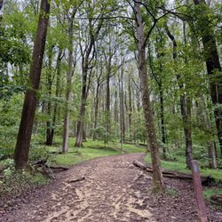
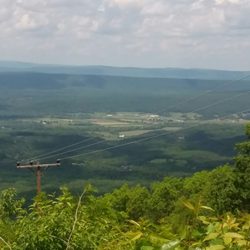
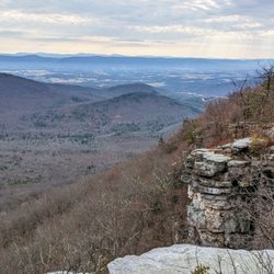
A great day for a hike on the A.T. This one is just o/s Fauquier County on Mt Weather. I took the SOBO trail a couple years ago. This time I went North to the waterfall. Let me give some mad respect to whomever dug out the spot to put in a rather large parking area for us! For years we've been on side of this narrow dirt road. * Thank. (Virtual fist pump). This was 3 miles out and 3 miles back. The waterfall is around 1 mile mark. It's off to the right. *please understand, ricks are slippery whether they're wet ot not. How someone brings three toddlers here with no backpack, water or first aid is beyond me. I had to leave the area. But it was really nice. Very relaxing and you did have to hand/foot climb to get up there. Be careful please. I double backed and got on the A.T. Couple more miles to the secret cliff I saw in another Yelp post. :) . Lots of people walked by, no one knew I was there. I had it all to myself. Its better than the actual lookout. Anyway. I scanned the rocks for danger, shot some pics and sat down for water and dry crackers. I look over and there are 2 snakes curled up by a small tree about 6 feet from me. I spoke to them. "Thought you'd hide from me. I got you!" It was funny. I took a couple pics and kept my eyes on them. Only takes a second to lose track and they end up right at me saying, "HA got you back!" I sat a while then headed back down. I enjoyed it! I'd like to section hike and have a car waiting to take me back to my own car where I started. They should have an Uber Hikes App available for that. ;) This way I can hike for as far as I want without turning around to come straight back. read more


 - Hiking Near Me - Bluemont, Virginia")
7 years ago
Short trail, pretty and cool, but the waterfall wasn't what I expected. The trail was well kept, and trimmed back, some areas were steep, and can be slick if it rains. read more


6 years ago
7 years ago
8 years ago
5 years ago
6 years ago
7 years ago
9 years ago
10 years ago
More info about Hollow Brook Trail
Ask the Community - Hollow Brook Trail
Review Highlights - Hollow Brook Trail


Hollow Brook Trail - hiking - Updated July 2026
Best of Bluemont
People found Hollow Brook Trail by searching for…
Hiking Trails With Waterfalls in Bluemont, VA
Swimming Holes in Bluemont, VA
Walking Trails in Bluemont, VA
Running Trails in Bluemont, VA
Off Road Trails in Bluemont, VA
Scenic Overlook in Bluemont, VA
Basketball Courts in Bluemont, VA
Lookout Points in Bluemont, VA
Browse Nearby
Browse Brands
Browse Articles
People who viewed Hollow Brook Trail also viewed
Buzzard Rock North Trail
15 reviews
Signal Knob Hike
5 reviews
Sweet Run State Park
4 reviews
Cool Spring Preserve
7 reviews
Third Winchester Battlefield Trails
6 reviews
Chet Hobert Park
4 reviews
Elizabeth Furnace Recreation Area
4 reviews
Harpers Ferry National Historical Park
177 reviews
Sherando Park
3 reviews
Inner Quest
2 reviews