
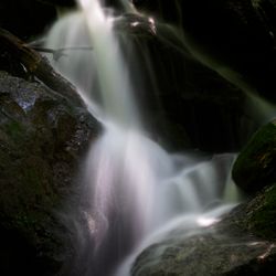
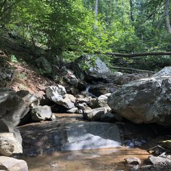
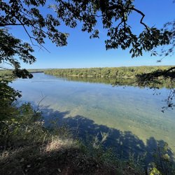
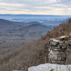
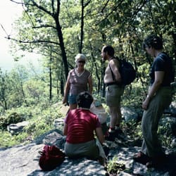
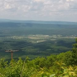
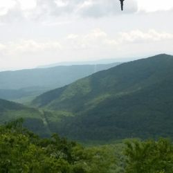
Raven Rocks Hike Photos


You might also consider
More like Raven Rocks Hike
Recommended Reviews - Raven Rocks Hike
Start your review...

Reviews With Photos - Raven Rocks Hike

I haven't hiked since August 2019 (so over 2 years) but I do walk about 5-7 miles daily. But wow, this was a pretty great yet challenging hike! I am not the most fit, so some of that uphill definitely got to me since it was so steep for awhile. The direction towards the overpass and all the views was definitely more difficult (more uphill) than the way back. The views were pretty nice but I wasn't overly impressed. One nice perk is that we were able to cross the Virginia and West Virginia state line, so I can add WV to my list of states visited now! The trail there and back is about 6 miles long. It took my friends and me 1.5 hours each way, with about one hour to enjoy lunch at the top and take pictures. Please bring a nice pair of running shoes. The whole path is basically made out of rocks. I had a few incidences where I wasn't careful and almost slipped multiple times. I find that going downhill was the most difficult since there are loose rocks or slippery dirt paths. The path was pretty much a rollercoaster - some pretty intense uphill followed by some downhills - kind of shaped like "ww". Overall, would recommend this path for hiking! I don't really know what beginner or advance level hiking paths are, but I was definitely tired at the end. There's no shame in taking breaks in between! Note, there are no public bathrooms so I don't recommend chugging too much water but definitely bring some to take a few sips here and there.

This was on the way home so stopped here on a Saturday afternoon to get some exercise in. Great place to hike with the hills, rocks, trees, and slopes. It's definitely not for beginners so bring your water bottles, proper footwear, and your stamina. Also get there early or late afternoon cause parking can be a you know what. There's some breweries/wineries/eats nearby to reward yourself after you trek here. And perfect to bring your pet to join you; if they are up to it!


This hike was so much fun! About 6 mile round trip from the parking lot to the view and back (not a loop). Where do I begin? Parking lot: It is small however a larger parking lot is across the divided highway by the trail head to the Appalachian trail heading to the south. There is lots of parking there. There is NO bathroom or porta potty available to either. Food: Lots of food nearby (bar and brewery) however the trailhead is a bit far from the center of town. Getting there: It is very easy to miss the trailhead because while on the highway, you have to turn right onto route 679 and then look right to see the trail head. This trail is the Appalachian trail so it is very well marked with a 2inch by 4inch white mark on trees and rocks. This trail consists of what Appalachian trail hikers call "PUDs" or "pointless ups and downs." You will definitely feel your lungs breathing heavy on multiple occasions however there always is a leveled area afterwards where you can catch your breath. I would say that this trail is rated medium to hard. Not an easy walk in the park, it is where a lot of people come to train. There are two stream crossings. Come prepared and have fun!


This is a great, challenging hike. Here's what to know: - Good shoes are a must. There are many steep rocky spots along the trail. I wouldn't go during rain or right after a rain unless you are experienced. - Bring water. I didn't notice a water fountain at the beginning of the hike. While it's well-shaded, the trail is constantly going up and down hill, so you might need more water than you think. - If you take a small dog or young child, you may need to carry them at certain points as their paws/ little feet might slip when crossing over some of the more rocky areas. - Know it's going to be a challenge. And there is absolutely nothing wrong with taking breaks and/or turning around if you/your dog/child/partner is exhausted. You'll still have a great time. - A walking stick would be useful given the steepness of some of the hills. - It's not a quick hike for most people and it can be very busy. - Since it's often busy, parking may be a problem. Apparently, they do tow in the "No parking" zone beside the small lot... so be mindful. Maybe carpool if you can! Have a great time!

I'm not a fan of out-and-back hikes, but I love the view at the top. * Amazing view at the overlook * Even amount of up and downhill so that the way to and back is pretty balanced * Trail running questionable...there are a lot of small rocks on the path * Great hike to do on sunny/hot day, because most of the trail is covered by trees. * Parking is pretty scarce though and you just park in a small area near the trailhead * Pay attention to the turn, or you might miss the trailhead! * One of the more secluded hikes, not too many people here. * No trail/entrance fee
")
What a great hike! Parking was a little dicey (we parked at the lot across RT 7) but otherwise easy to get to starting point. Hike itself was strenuous (inclines, rocks, etc) so be aware if you have knee/joint issues. Also, bring water! Views were worth the effort. Do not recommend for small children and pets.

Steep and rocky! Great hike though. It's a super good workout. I went with my man and we went this past weekend, the traffic despite COVID was still pretty moderate. Not too crowded but we went at 8 am, the crowd started to increase around 9:30 am so if you want to avoid that, I'd recommend going early. The full round trip hike is only 6 miles but man, does it feel like more!! If you're scared of heights, don't try this one- or do, but Never! Look! Down! View once you reach the top is really nice and super cool that during the hike you pass the VA/WV state line.

I think this is a great hike if you're already in the area or have already done a lot of hiking in Virginia and want to see something new-- but otherwise there are definitely better hikes in Virginia. Pros: It was shady the entire way The ups and downs were really balanced so every time I thought I was getting really tired we happened to get to flat ground for awhile. (My 60 year old dad was less impressed-- it was a pretty difficult day for him.) The view at the top is good We passed a good number of people but generally were alone. It's free! Cons: Supposedly they tow people parked illegally at the entrance, but several people were definitely parked illegally and there didn't seem to be a problem. Not the BEST views from the top, and very few views along the way. Not much scenery generally, just a serene woodsy walk.

Another day, another great hike. This one though was very different. Like Arin says, it does go up and down bringing balance to the extremely long hike. Somehow, I failed to note it was an 11 mile round trip hike! We started out good and strong. very shady. Lots of rocks. Be careful. Watch where you step. Crossed two creeks. I think over three mountains! It's not just one mountain...you clearly cross creeks and start back up another mountain. 10 min to the top and BAM!!!! A torential rain fell upon us like none other! The whole forest was dark as night! Seriously. It was amazing!!!!!!!! It did cool off our sweaty bodies and gave us a second wind though. The rain was monsterous. As the rain was stopping we stepped out onto the cliff's edge! Fog from the rain and hot Earth coming out of the tree lines. You could track the storm across WV from the cliffs. Again, Amazing!!! Shot some pic....ate some cheetos and cashews, and started back to the start line. Obviously, after the rains it was a sloppy mess! The water also weighted down our apparal and hiking sacks. A lot different from coming in. Wet and soggy we trudged on...and on....and on....seriously another 10 min to the finish line where we parked, that rain started again. Pelting us! Dark again was the forest..We jumped in the car and drove off. So- Wildlife? We saw a bumblebee, that stung me 3 times. (WTH), a black snake I almost stepped on! A Millipede, a Centepede, a fluffy catapillar, a big black beetle... We may have made it there and back, but on this day ladies and gentlemen, Water Won!

8 months ago
I haven't hiked since August 2019 (so over 2 years) but I do walk about 5-7 miles daily. But wow, this was a pretty great yet challenging hike! I am not the most fit, so some of that uphill definitely got to me since it was so steep for awhile. The direction towards the overpass and all the views was definitely more difficult (more uphill) than the way back. The views were pretty nice but I wasn't overly impressed. One nice perk is that we were able to cross the Virginia and West Virginia state line, so I can add WV to my list of states visited now! The trail there and back is about 6 miles long. It took my friends and me 1.5 hours each way, with about one hour to enjoy lunch at the top and take pictures. Please bring a nice pair of running shoes. The whole path is basically made out of rocks. I had a few incidences where I wasn't careful and almost slipped multiple times. I find that going downhill was the most difficult since there are loose rocks or slippery dirt paths. The path was pretty much a rollercoaster - some pretty intense uphill followed by some downhills - kind of shaped like "ww". Overall, would recommend this path for hiking! I don't really know what beginner or advance level hiking paths are, but I was definitely tired at the end. There's no shame in taking breaks in between! Note, there are no public bathrooms so I don't recommend chugging too much water but definitely bring some to take a few sips here and there. read more


This was on the way home so stopped here on a Saturday afternoon to get some exercise in. Great place to hike with the hills, rocks, trees, and slopes. It's definitely not for beginners so bring your water bottles, proper footwear, and your stamina. Also get there early or late afternoon cause parking can be a you know what. There's some breweries/wineries/eats nearby to reward yourself after you trek here. And perfect to bring your pet to join you; if they are up to it! read more


2 years ago
Awesome hike! A little challenging for the average hiker but all in all it was amazing for me and my buddies. The view was well worth the climb. Will definitely be coming back read more


8 years ago
This hike was so much fun! About 6 mile round trip from the parking lot to the view and back (not a loop). Where do I begin? Parking lot: It is small however a larger parking lot is across the divided highway by the trail head to the Appalachian trail heading to the south. There is lots of parking there. There is NO bathroom or porta potty available to either. Food: Lots of food nearby (bar and brewery) however the trailhead is a bit far from the center of town. Getting there: It is very easy to miss the trailhead because while on the highway, you have to turn right onto route 679 and then look right to see the trail head. This trail is the Appalachian trail so it is very well marked with a 2inch by 4inch white mark on trees and rocks. This trail consists of what Appalachian trail hikers call "PUDs" or "pointless ups and downs." You will definitely feel your lungs breathing heavy on multiple occasions however there always is a leveled area afterwards where you can catch your breath. I would say that this trail is rated medium to hard. Not an easy walk in the park, it is where a lot of people come to train. There are two stream crossings. Come prepared and have fun! read more


Great moderate level there and back hike. Lots of ups and downs as you traverse the valley. The views up top aren't fantastic but nevertheless a scenic view. It was roughly 5 miles. Not too crowded when we arrived but on our way back it was really crowded. read more


3 years ago
This is a great, challenging hike. Here's what to know: - Good shoes are a must. There are many steep rocky spots along the trail. I wouldn't go during rain or right after a rain unless you are experienced. - Bring water. I didn't notice a water fountain at the beginning of the hike. While it's well-shaded, the trail is constantly going up and down hill, so you might need more water than you think. - If you take a small dog or young child, you may need to carry them at certain points as their paws/ little feet might slip when crossing over some of the more rocky areas. - Know it's going to be a challenge. And there is absolutely nothing wrong with taking breaks and/or turning around if you/your dog/child/partner is exhausted. You'll still have a great time. - A walking stick would be useful given the steepness of some of the hills. - It's not a quick hike for most people and it can be very busy. - Since it's often busy, parking may be a problem. Apparently, they do tow in the "No parking" zone beside the small lot... so be mindful. Maybe carpool if you can! Have a great time! read more
I'm not a fan of out-and-back hikes, but I love the view at the top. * Amazing view at the overlook * Even amount of up and downhill so that the way to and back is pretty balanced * Trail running questionable...there are a lot of small rocks on the path * Great hike to do on sunny/hot day, because most of the trail is covered by trees. * Parking is pretty scarce though and you just park in a small area near the trailhead * Pay attention to the turn, or you might miss the trailhead! * One of the more secluded hikes, not too many people here. * No trail/entrance fee read more


4 years ago
6 years ago
What a great hike! Parking was a little dicey (we parked at the lot across RT 7) but otherwise easy to get to starting point. Hike itself was strenuous (inclines, rocks, etc) so be aware if you have knee/joint issues. Also, bring water! Views were worth the effort. Do not recommend for small children and pets. read more
 - Hiking Near Me - Bluemont, Virginia")


6 years ago
Steep and rocky! Great hike though. It's a super good workout. I went with my man and we went this past weekend, the traffic despite COVID was still pretty moderate. Not too crowded but we went at 8 am, the crowd started to increase around 9:30 am so if you want to avoid that, I'd recommend going early. The full round trip hike is only 6 miles but man, does it feel like more!! If you're scared of heights, don't try this one- or do, but Never! Look! Down! View once you reach the top is really nice and super cool that during the hike you pass the VA/WV state line. read more


I think this is a great hike if you're already in the area or have already done a lot of hiking in Virginia and want to see something new-- but otherwise there are definitely better hikes in Virginia. Pros: It was shady the entire way The ups and downs were really balanced so every time I thought I was getting really tired we happened to get to flat ground for awhile. (My 60 year old dad was less impressed-- it was a pretty difficult day for him.) The view at the top is good We passed a good number of people but generally were alone. It's free! Cons: Supposedly they tow people parked illegally at the entrance, but several people were definitely parked illegally and there didn't seem to be a problem. Not the BEST views from the top, and very few views along the way. Not much scenery generally, just a serene woodsy walk. read more

6 years ago
8 years ago
14 years ago
10 years ago
11 years ago
Another day, another great hike. This one though was very different. Like Arin says, it does go up and down bringing balance to the extremely long hike. Somehow, I failed to note it was an 11 mile round trip hike! We started out good and strong. very shady. Lots of rocks. Be careful. Watch where you step. Crossed two creeks. I think over three mountains! It's not just one mountain...you clearly cross creeks and start back up another mountain. 10 min to the top and BAM!!!! A torential rain fell upon us like none other! The whole forest was dark as night! Seriously. It was amazing!!!!!!!! It did cool off our sweaty bodies and gave us a second wind though. The rain was monsterous. As the rain was stopping we stepped out onto the cliff's edge! Fog from the rain and hot Earth coming out of the tree lines. You could track the storm across WV from the cliffs. Again, Amazing!!! Shot some pic....ate some cheetos and cashews, and started back to the start line. Obviously, after the rains it was a sloppy mess! The water also weighted down our apparal and hiking sacks. A lot different from coming in. Wet and soggy we trudged on...and on....and on....seriously another 10 min to the finish line where we parked, that rain started again. Pelting us! Dark again was the forest..We jumped in the car and drove off. So- Wildlife? We saw a bumblebee, that stung me 3 times. (WTH), a black snake I almost stepped on! A Millipede, a Centepede, a fluffy catapillar, a big black beetle... We may have made it there and back, but on this day ladies and gentlemen, Water Won! read more


14 years ago
Nice hike that was closer to me than Shenandoah so I decided to use this trail to break in my new trekking poles. I used to be one of those elitists who raised their nose at people who used trekking poles. Uh, yeah, not anymore. There were countless times when they kept me from falling on this extremely rocky trail. Was quite busy as expected, but fortunately I passed everyone (~ 17 hikers) on my way back down from the top, which I was lucky enough to have all to myself for 20 minutes. Just get here really early (I started 6:30am). read more


11 years ago
Awesome hike .... Yesterday weather was a mixture of sun and downpours or rain . Trail had a lot of ups and downs but we kept up a good pace and made to the overlook in about 2 1/2 hrs . It was beautiful. I would definitely recommend this trail read more


5 stars due to proximity to our house! We live in Purcellville and I'm pretty sure this is the closest hiking trail to us. We took our toddler with us who does awesome on trails but didn't realize this was a more rocky/ steep climb than most trails in the area so just be ready for that. read more


5 years ago
8 years ago
13 years ago
Came here from Northern Virginia and it was amazing. The parking was the trickiest part of the hike, because it is very limited especially on a nice day. Other than that there are beautiful overlooks and miles of forest (about 5.5). Once you get to the top you experience the most incredible view stretching miles into the distance. read more


9 years ago
12 years ago
16 years ago
5 stars mainly because this particular hike has some great walls to climb on. Plus we have a secret little area somewhat away from the masses that gather on the outlook post AND we still have the views. The hike is a perfect combination of switchbacks - not to difficult but difficult enough to get your heart rate up and make you go "why did I eat that (whole) pizza last night!" haha. Great views for being such a short drive from the metro area. Come prepared people. Bring plenty of water, layer up and wear proper footwear. This trail is extremely rocky with some parts being sandy with loose gravel. The views are beautiful and a great place to lounge for lunch or in a hammock! Which is what I did most of the afternoon - well deserved rest if I don't say so myself. Looks like a great place for a one nighter camping trip too. Maybe too heavy with foot traffic but I'm sure if you search you can find a quiet spot tucked away from the main trail. Beautiful and would definitely recommend this one. read more


10 years ago
Fun, but strenuous! Trail was well-marked, and terrain was varying (leafy; rocky; stream beds). Nice view from the top. My sister's miniature pinscher made it, so you can too! read more

12 years ago
8 years ago
11 years ago
More info about Raven Rocks Hike
Ask the Community - Raven Rocks Hike
Review Highlights - Raven Rocks Hike


Why does Yelp recommend reviews?
2 reviews that are not currently recommended
The reviews below are not factored into the business's overall star rating.
2 years ago
10 years ago
Raven Rocks Hike - hiking - Updated July 2026
Best of Bluemont
People found Raven Rocks Hike by searching for…
Hiking Trails With Waterfalls in Bluemont, VA
Swimming Holes in Bluemont, VA
Scenic Overlook in Bluemont, VA
Dog Friendly Hiking Trails in Bluemont, VA
Walking Trails in Bluemont, VA
Running Trails in Bluemont, VA
Parks for Kids in Bluemont, VA
Off Road Trails in Bluemont, VA
Hiking With Kids in Bluemont, VA
Easy Hiking Trails in Bluemont, VA
Stairs Workout in Bluemont, VA
Hikes With Dogs in Bluemont, VA
Great View Points at Night in Bluemont, VA
Browse Nearby
Browse Brands
Browse Articles
People who viewed Raven Rocks Hike also viewed
Hollow Brook Trail
12 reviews
Buzzard Rock North Trail
15 reviews
Sweet Run State Park
4 reviews
Third Winchester Battlefield Trails
6 reviews
Weverton Cliff Trail
8 reviews
Piscataway Crossing Regional Park
5 reviews
Chet Hobert Park
4 reviews
Cool Spring Preserve
7 reviews
Gilbert's Corner Regional Park
8 reviews
Washington & Old Dominion Trail
60 reviews