Jefferson Rock Photos


You might also consider
More like Jefferson Rock
Recommended Reviews - Jefferson Rock
Start your review...

Reviews With Photos

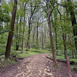
This is a short and very scenic hike! Lots of stairs and it's a bit tricky, which adds all the more adventurous and fun to the trail! It is not a hard one but not easy either. If you're afraid of height, bring good shoes, a hiking pole, and a buddy. Otherwise, enjoy and jog this whole thing if you want! There are many ways to the rock and you can do a loop that goes through the cemetery! Great view and so historical! Highly recommend!

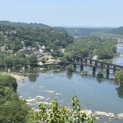
Thomas Jefferson stood on this spot and found it to have one of the most stupendous scenes in nature. The area is surrounded by large rocks to stand or sit on and chill, forming a good viewing area. It is not recommend to stand on the actual rock as it is unstable. The view is decent but not the best. While views to the left and right are fantastic you can't see the river right below as there's trees in the way.

Okay, so the guy's review below mine is informative, but it really doesn't have anything to do with the listing of this business. Even though technically this isn't a business, it is talking about a rock. A rock that Thomas Jefferson wrote about his experience visiting Harper's Ferry in 1783. Supposedly this is the rock that he was hanging out on when he declared his love for the area. I snapped a few shots for you to look at, and it provides the view of the rock and the view that you can see from the rock. The rock itself is covered with carvings of people's initials in it. People were also climbing on it. Unless you are skillful at climbing, I wouldn't exactly advise it since it is a little slippery. I managed, but I could see someone having an accident here and I would really hate to see the day when it happened. Don't forget to walk past the rock further up the hill to go visit the cemetery and Lockwood house.

Thomas Jefferson was in awe at this spot. He took a nice rest here and created notes about this point. At the time, this rock could be pushed over the side of the mountain. It was a bit unstable but impressive none-the-less. He fully enjoyed, as we do now, the scenery from this rock. It's breathtaking. One hundred years later the 4 rock "legs" were added to make the rock more stable. And there is still sits. Thank you to all the tourists and locals that this area remains graffiti free! It's beautful.

This is a beautiful place to visit while in Harper's Ferry. It's not a very difficult walk up many steps to the top of this rock, which overlooks the town below. It's also about ¾ of the way to the top where there's a very old cemetery which is also worth a visit. This is a very nice place to take a picture of your visit to Harper's Ferry as well!

9 months ago
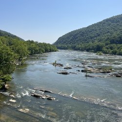
An interesting story and a nice view above Harper's Ferry Jefferson Rock is one of the highlights of Harpers Ferry. It gives a good mix of history, scenery, and a bit of historic adventure that personifies the town. The hike to the rock takes you up the hillside, passing by the iconic St. Peter's Catholic Church along the way. The path itself is fairly manageable, and most sections have railings, but once you reach the rock the protection stops. Because of this, I would recommend the visit only for those who are sure-footed and comfortable with uneven ground, as the drop-offs can be intimidating without barriers. The payoff, however, is worth the effort. From a position next to the rock you get a sweeping view of the confluence of the Shenandoah and Potomac Rivers, as well as the historic town of Harpers Ferry nestled below. The vantage point is both dramatic and peaceful, giving you a sense of why, according to the stories, Thomas Jefferson, during his travels, found this very spot so moving that it now bears his name. For those who wish to explore more, you can continue on the trail past Jefferson Rock and make your way to the Appalachian trail, which adds another layer of history to the walk. The informational sign could use a little care but, overall, this is a scenic and meaningful stop, best enjoyed with good shoes and sure footing. Enjoy. read more


Rock formation on ApplachainTrail, a short distance from lower town of Harpers Ferry, yet a steep and very uneven climb to get there - be careful. The rock/area is famous for Thomas Jefferson standing there in 1783 and stating "worth a voyage across the Atlantic." It is a breath taking view! You pass the remains of St Johns Episcopol church and St Peters Church along the way. Worth the walk! read more


3 years ago
Short and scenic hike. Breathtaking view! Lots of stairs to go up but it's worth it. It was very quiet when we were there. You can just sit there, read a book while enjoying the gorgeous view. Highly recommended if you are in Harpers Ferry. read more


This is a short and very scenic hike! Lots of stairs and it's a bit tricky, which adds all the more adventurous and fun to the trail! It is not a hard one but not easy either. If you're afraid of height, bring good shoes, a hiking pole, and a buddy. Otherwise, enjoy and jog this whole thing if you want! There are many ways to the rock and you can do a loop that goes through the cemetery! Great view and so historical! Highly recommend! read more


2 years ago
6 years ago
Thomas Jefferson stood on this spot and found it to have one of the most stupendous scenes in nature. The area is surrounded by large rocks to stand or sit on and chill, forming a good viewing area. It is not recommend to stand on the actual rock as it is unstable. The view is decent but not the best. While views to the left and right are fantastic you can't see the river right below as there's trees in the way. read more


11 years ago
Okay, so the guy's review below mine is informative, but it really doesn't have anything to do with the listing of this business. Even though technically this isn't a business, it is talking about a rock. A rock that Thomas Jefferson wrote about his experience visiting Harper's Ferry in 1783. Supposedly this is the rock that he was hanging out on when he declared his love for the area. I snapped a few shots for you to look at, and it provides the view of the rock and the view that you can see from the rock. The rock itself is covered with carvings of people's initials in it. People were also climbing on it. Unless you are skillful at climbing, I wouldn't exactly advise it since it is a little slippery. I managed, but I could see someone having an accident here and I would really hate to see the day when it happened. Don't forget to walk past the rock further up the hill to go visit the cemetery and Lockwood house. read more


8 years ago
Thomas Jefferson was in awe at this spot. He took a nice rest here and created notes about this point. At the time, this rock could be pushed over the side of the mountain. It was a bit unstable but impressive none-the-less. He fully enjoyed, as we do now, the scenery from this rock. It's breathtaking. One hundred years later the 4 rock "legs" were added to make the rock more stable. And there is still sits. Thank you to all the tourists and locals that this area remains graffiti free! It's beautful. read more


10 years ago
This is a beautiful place to visit while in Harper's Ferry. It's not a very difficult walk up many steps to the top of this rock, which overlooks the town below. It's also about ¾ of the way to the top where there's a very old cemetery which is also worth a visit. This is a very nice place to take a picture of your visit to Harper's Ferry as well! read more


10 years ago
On March 8th 2016 I climbed up to Jefferson Rock. It is in Harpers Ferry part of the Appalachian trail. It is a rock formation that over looks the Shenandoah River. It's a rock formation. The name of this landmark derives from Thomas Jefferson, who stood there on October 25, 1783. He found the view from the rock impressive and wrote in Notes on the State of Virginia that "this scene is worth a voyage across the Atlantic". I am giving it 5 stars because it really is a pretty view, a steep climb up, and it's cool that I can stand where Jefferson stood. read more

More info about Jefferson Rock
Harpers Ferry, WV 25425
Directions
Hours
Outdoor Amenities
Ask the Community - Jefferson Rock
Review Highlights - Jefferson Rock


Jefferson Rock - hiking - Updated May 2026
Best of Harpers Ferry
People found Jefferson Rock by searching for…
Things to Do in Harpers Ferry, WV
Photo Spots in Harpers Ferry, WV
Scenic Overlook in Harpers Ferry, WV
Scenic View in Harpers Ferry, WV
Star Gazing in Harpers Ferry, WV
Hiking Trails in Harpers Ferry, WV
Sunset View in Harpers Ferry, WV
Places to Take Pictures in Harpers Ferry, WV
Beautiful Views in Harpers Ferry, WV
Playgrounds in Harpers Ferry, WV
Walking Trails in Harpers Ferry, WV
River Swimming in Harpers Ferry, WV
Picnic Areas in Harpers Ferry, WV
Parks for Kids in Harpers Ferry, WV
Free Things to Do With Kids in Harpers Ferry, WV
Scenic Drive in Harpers Ferry, WV
View Points in Harpers Ferry, WV
Restaurants With a View in Harpers Ferry, WV
Secluded Spots in Harpers Ferry, WV
Attraction in Harpers Ferry, WV
Fun Places to Go in Harpers Ferry, WV
Trending Searches in Harpers Ferry, WV
Baseball Fields near Jefferson Rock
Boat Rental near Jefferson Rock
Botanical Gardens near Jefferson Rock
Bounce House Rentals near Jefferson Rock
Campgrounds near Jefferson Rock
Cheap Plants near Jefferson Rock
Cliff Jumping near Jefferson Rock
Floral Designers near Jefferson Rock
Flower Fields near Jefferson Rock
Flower Shop near Jefferson Rock
Garden Center near Jefferson Rock
Lakes & Ponds near Jefferson Rock
Nurseries & Gardening near Jefferson Rock
Outdoor Activities near Jefferson Rock
Outdoor Furniture Stores near Jefferson Rock
Party Equipment Rentals near Jefferson Rock
Photo Spots near Jefferson Rock
Picnic Areas near Jefferson Rock
Places To Take Pictures near Jefferson Rock
Places To Take Pictures For Prom near Jefferson Rock
Playgrounds near Jefferson Rock
Public Running Track near Jefferson Rock
Public Shower near Jefferson Rock
Rock Quarry near Jefferson Rock
Running Trails near Jefferson Rock
Scenic Drive near Jefferson Rock
Sunrise View near Jefferson Rock
Swimming Holes near Jefferson Rock
Table And Chair Rentals near Jefferson Rock
Watch Sunset near Jefferson Rock
Browse Nearby
BEST of Harpers Ferry, West Virginia Restaurants near Jefferson Rock
BEST of Harpers Ferry, West Virginia Coffee near Jefferson Rock
BEST of Harpers Ferry, West Virginia Things to Do near Jefferson Rock
BEST of Harpers Ferry, West Virginia Breakfast near Jefferson Rock
BEST of Harpers Ferry, West Virginia Beaches near Jefferson Rock
BEST of Harpers Ferry, West Virginia Horseback Riding near Jefferson Rock
BEST of Harpers Ferry, West Virginia Campgrounds near Jefferson Rock
BEST of Harpers Ferry, West Virginia Hotels near Jefferson Rock
Browse Brands
Related Searches in Harpers Ferry, WV
Affordable Kayak Rental Services in Harpers Ferry, West Virginia
Best Fishing Locations and Guides in Harpers Ferry, West Virginia
Best Parks for Parties and Events in Harpers Ferry, West Virginia
Best Places for Horseback Riding in Harpers Ferry, West Virginia
Best Spots for Star Gazing in Harpers Ferry, West Virginia
Best Waterfalls and Swimming Holes in Harpers Ferry, West Virginia
Check Out Off Road Trails in Harpers Ferry, West Virginia
Discover Baseball Fields Around Harpers Ferry, West Virginia
Discover Dog Friendly Trails to Explore in Harpers Ferry, West Virginia
Discover Free Parking Options in Harpers Ferry, West Virginia
Discover Kids Indoor Play Area Venues in Harpers Ferry, West Virginia
Discover Lakes & Ponds to Explore in Harpers Ferry, West Virginia
Discover Popular Photo Spots in Harpers Ferry, West Virginia
Discover Top Nature Parks to Visit in Harpers Ferry, West Virginia
Discover Top State Parks to Visit in Harpers Ferry, West Virginia
Discover a Hiking Trail in Harpers Ferry, West Virginia
Discover the Best Beaches in Harpers Ferry, West Virginia
Discover the Best Night Hike Trails in Harpers Ferry, West Virginia
Dog-Friendly Hikes With Dogs in Harpers Ferry, West Virginia
Enjoy Camping Adventures Around Harpers Ferry, West Virginia
Enjoy Exciting Mountain Biking Adventures in Harpers Ferry, West Virginia
Enjoy Kayaking Adventures in Harpers Ferry, West Virginia
Enjoy River Tubing Adventures in Harpers Ferry, West Virginia
Enjoy Tent Camping Spots Around Harpers Ferry, West Virginia
Enjoy the Best Tubing Experiences in Harpers Ferry, West Virginia
Exciting Cliff Jumping Spots in Harpers Ferry, West Virginia
Experience Thrilling White Water Rafting in Harpers Ferry, West Virginia
Explore Beautiful Botanical Gardens in Harpers Ferry, West Virginia
Explore Beautiful Parks and Green Spaces in Harpers Ferry, West Virginia
Explore Bike Rentals Throughout Harpers Ferry, West Virginia
Explore Easy Hikes Perfect for All in Harpers Ferry, West Virginia
Explore Family-Friendly Zoos and Wildlife in Harpers Ferry, West Virginia
Explore Free Picnic Areas Around Harpers Ferry, West Virginia
Explore Fun Activities to Do in Harpers Ferry, West Virginia
Explore Landmarks & Historical Buildings in Harpers Ferry, West Virginia
Explore Parks With Pull Up Bars in Harpers Ferry, West Virginia
Explore Popular Campgrounds Near Harpers Ferry, West Virginia
Explore Popular Picnic Areas Around Harpers Ferry, West Virginia
Explore Popular RV Parks Around Harpers Ferry, West Virginia
Explore Popular Recreation Centers Around Harpers Ferry, West Virginia
Explore Popular Scenic Overlook Points in Harpers Ferry, West Virginia
Explore Scenic Lakes to Visit in Harpers Ferry, West Virginia
Explore Secret Spots Worth Visiting in Harpers Ferry, West Virginia
Explore Top Dog Parks in Harpers Ferry, West Virginia Near You
Explore Top Gyms in Harpers Ferry, West Virginia Now
Explore Top Water Parks in Harpers Ferry, West Virginia Today
Explore the Best Boating Spots in Harpers Ferry, West Virginia
Explore the Best Swimming Holes Around Harpers Ferry, West Virginia
Family Friendly Hiking With Kids in Harpers Ferry, West Virginia
Browse Articles
People who viewed Jefferson Rock also viewed
Harpers Ferry National Historical Park
176 reviews
Washington Monument State Park
21 reviews
Cool Spring Preserve
6 reviews
Hollow Brook Trail
12 reviews
Sweet Run State Park
4 reviews
Weverton Cliff Trail
8 reviews
C&O Canal
12 reviews
Ballenger Creek Trail
2 reviews
Greenbrier State Park
71 reviews
Piscataway Crossing Regional Park
5 reviews