The Stowe Trail Photos


You might also consider
More like The Stowe Trail
Recommended Reviews - The Stowe Trail
Start your review...

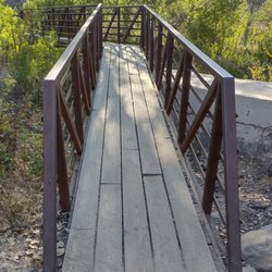
This hiking trail starts near Santee Lakes and ends in Sycamore Canyon/Goodan Ranch County Preserve in Poway. Some sections run through MCAS Miramar / private properties. Park rangers at Sycamore Canyon told me that' a permit from MCAS is required for bikers but not for hikers on foot. Still a lot of flowers yesterday (6-11-23) read more


More info about The Stowe Trail
10400 Fanita Pkwy
Santee, CA 92071
Directions
Hours
Outdoor Amenities
You might also consider


The Stowe Trail - hiking - Updated July 2026
Best of Santee
People found The Stowe Trail by searching for…
Hiking Trails in Santee, California
Fun Things to Do in Santee, California
Walking Trails in Santee, California
Free Things to Do in Santee, California
Running Trails in Santee, California
Lakes & Ponds in Santee, California
Places to Run in Santee, California
Off Road Trails in Santee, California
Things to Do at Night in Santee, California
Places to Walk at Night in Santee, California
Night Walk in Santee, California
Bike Path in Santee, California
Places to Walk in Santee, California
Off Leash Dog Hikes in Santee, California
Canyoneering in Santee, California
Scenic View in Santee, California
Nature Walks in Santee, California
Park & Forests in Santee, California
Fall Foliage in Santee, California
Trending Searches in Santee, CA
Browse Articles
Browse Nearby
BEST of Santee, California Coffee near The Stowe Trail
BEST of Santee, California Restaurants near The Stowe Trail
BEST of Santee, California Things to Do near The Stowe Trail
BEST of Santee, California Breakfast near The Stowe Trail
BEST of Santee, California Walking Trails near The Stowe Trail
BEST of Santee, California Parks near The Stowe Trail
BEST of Santee, California Hot Springs near The Stowe Trail
Browse Brands
Related Searches in Santee, CA
Affordable Kayak Rental Services in Santee, California
Best Fishing Locations and Guides in Santee, California
Best Places for Horseback Riding in Santee, California
Best Waterfalls and Swimming Holes in Santee, California
Check Out Off Road Trails in Santee, California
Discover Dog Friendly Trails to Explore in Santee, California
Discover Scenic Hiking Trails in Santee, California
Discover Scenic Mountain Bike Trails Near Santee, California
Discover Walking Parks in Santee, California Near You
Discover a Hiking Trail in Santee, California
Discover the Best Night Hike Trails in Santee, California
Dog-Friendly Hikes With Dogs in Santee, California
Enjoy Camping Adventures Around Santee, California
Enjoy Exciting Mountain Biking Adventures in Santee, California
Enjoy Kayaking Adventures in Santee, California
Enjoy Tent Camping Spots Around Santee, California
Enjoy a Beautiful Waterfall Hike in Santee, California
Enjoy a Peaceful Nature Walk in Santee, California
Enjoy the Best Picnic Spots and Ideas in Santee, California
Enjoy the Best Walking Path in Santee, California
Enjoy the Best Walking Trails in Santee, California
Exciting Cliff Jumping Spots in Santee, California
Explore Beautiful Parks and Green Spaces in Santee, California
Explore Easy Hikes Perfect for All in Santee, California
Explore Fun Activities to Do in Santee, California
Explore Popular Campgrounds Near Santee, California
Explore the Best Beach Spots in Santee, California
Explore the Best Trail Options in Santee, California
Family Friendly Hiking With Kids in Santee, California
Find Beautiful Views in Santee, California
Find Popular Ziplining Spots Around Santee, California
Find the Best Parks for Picnics in Santee, California
Find the Best Scenic View Locations in Santee, California
Great Places to Walk in Santee, California
Hike the Popular Waterfall Trail in Santee, California
Hiking Trails With Waterfalls in Santee, California
Off Leash Dog Hiking Trails in Santee, California
Plan a Scenic Drive Route Near Santee, California
Popular Outdoor Activities to Try in Santee, California
Popular Picnic Spots to Visit in Santee, California
Safe River Swimming Areas in Santee, California
Safe and Fun Parks for Kids in Santee, California
Top Climbing Spots and Gyms in Santee, California
Top Paddleboarding Activities in Santee, California
Top Places for Snorkeling in Santee, California
Top Running Trails to Explore in Santee, California
Top Swimming Lakes to Enjoy in Santee, California
Top Swimming Spots and Pools in Santee, California