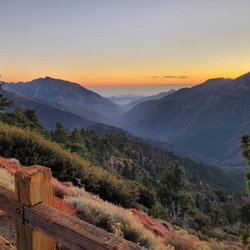
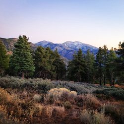
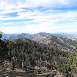
Mt.Islip Photos


You might also consider
More like Mt.Islip
Recommended Reviews - Mt.Islip
Start your review...

1 year ago
It's a pretty steep hike, but it's absolutely worth it for the views. If you are fit and healthy, I'd highly recommend trying out the mount Islip trail. It took me about 4.5 hours to complete, 9.5 miles from Crystal Lake to the windy gap trail read more


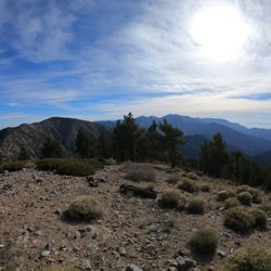
I have done Islip a few times and love this area. I have even hike up to Mt Islip from Crystal Lake. This review will be a 5 peak challenge that I did. You need to hike with someone and drive separate cars so you can leave one car at the Vincent Gap parking lot. This will allow you to do the 5 peaks all in one directions without having to make the hike much longer by hiking back to your starting point. Here are the 5 peaks in the order you will do them in if you decide to take on this challenge: Islip, Mount Hawkins, Throop Peak, Mount Burnham, and lastly one of my all time favorite peaks...Baden-Powell. Parking- so again you leave one car at the Vincent Gap parking lot which is used for people who are hiking to Big Horn Mine or Baden-Powell; you and the person you are hiking with will drive another 10 minutes or so until you get to the trailhead for Mount Islip. Trail (Peak 1)You will hike by the Little Jimmy Campground until aroun 2 or 2.5 miles you will reach an intersection where the PCT and Windy Gap connect...at this intersection you need to go to the right which is the Mount Islip trail and after about another mile you will reach your first peak, Mt. Islip, which has the remnants of a stone structure (elev. 8,262) and there are great views down toward Azusa and on a clear day all the way toward the ocean and even Catalina with views in the opposite direction toward the high desert Trail (Peak 2)- you will follow the same trail back to the intersection with the PCT and these next 2 miles to the 2nd peak will be the steepest but nothing too bad until you reach Mount Hawkins (elev. 8,783) at this point you will have hiked a little over 6 miles and 2 or 3 hrs so might be a good idea to take a little longer of a break to eat something...there was no sign or marker that we found here to officially signify Mount Hawkins but it will be the highest spot in the area and if you are using All Trails map it will show that you have reched the peak Trail (Peak 3)- continue on the PCT toward Throop Peak for about .75 miles and you might be able to find more than one way from the PCT trail up to this peak and there is a marker to confirm when you reach this summit (elev. 9,118) Trail (Peak 4)- continue on the PCT for a little over a mile and you will reach Mount Bunham (elev. 8,990) and there was no sign or marker when we hiked it *we saw less than 10 people during the first 9 miles and these 4 peaks the whole morning during the 4 hours or so...that is about to change as you hike the last 5 miles to Baden-Powell and the Vincent Gap parking lot...this trail is much more popular and crowded and we probably came across nearly 100 people in the last 5 miles Trail (Peak 5)- you will hike a little over a mile to reach Baden-Powell which has amazing views, there is a monument to the founder of the Boy Scouts which the mountain is named after and you will usually find a wooden sign or two and a flag at the summit...this peak sometimes has a lot of people but there is plenty of room at the top for everyone to spread out comfortably...enjoy the views (elev. 9,384) and you will head down the PCT to the parking lot where you left the other car in the morning Distance- about 14 miles Elevation Gain- a little over 4,000 feet Difficulty- hard because of the overall distance and some people may have trouble with the altitude but on the easy side of hard because it is not overwhelmingly steep in any part and the gain is nice and gradual Duration- anywhere between 6-8 hrs of course depending on your pace as well as how long of a break you take at each peak read more
 - Hiking Near Me")
 - Hiking Near Me")
 - Hiking Near Me")
 - Hiking Near Me")

 - Hiking Near Me")
6 years ago
Islip Saddle to Little Jimmy Campground to Windy Gap and Mt. Islip Distance: 7 miles Elevation Gain: 1,669 feet Route Type: Out & Back or Loop Started from the Islip Saddle - mile marker 64.1 on the Angeles Crest Highway. Mount Islip is a 8,250-foot peak provides impressive views of the Mojave Deserts, the Los Angeles Basin, Santa Catalina Island, and San Clemente Island. read more


I recently got into backpacking and my friends and I researched to find that Little Jimmy and Mt. Islip is a great 'introductory' trip for it. Located about 2 miles away from Islip Saddle the Little Jimmy campground is a wonderful site with all the necessary 'amenities.' There is a wonderful super fresh and cold spring that provided the water for the duration of our trip. I can honestly drinking this water was like drinking pure gold after a day of hiking (Note: I used a Sawyer Filter). Although we were unable to have a bonfire I was able to use my mini stove pocket rocket and boil some water for food and eat hot food. Typically, you would be able to use the provided BBQ pots or wood stoves at the site. We went when there was literally no one there so there were ample places to pitch our tent and place our stuff in bear lockers. Speaking of bears, in the middle of the night I was woken up by footsteps around my tent but I was not brave enough to peak outside. Fortunately, I'm alive to write this review but you have been warned. Yes, it's bear country but there have been no recorded attacks in the area ever. The hike to Mt. Islip is 1.5 miles from camp and at the peak you can see Crystal Lake, which is not too far, and the reservoir. They usually have bathrooms but it was not available so having a trowel or shovel is very handy...actually more like necessary. Haha it reminded me of the little boy from UP. I forget if his name was Jimmy or Russell? Nice. read more


More info about Mt.Islip
Valyermo, CA 93544
Directions
Hours
Outdoor Amenities