Mt Gower County Preserve Photos


You might also consider
More like Mt Gower County Preserve
Recommended Reviews - Mt Gower County Preserve
Start your review...

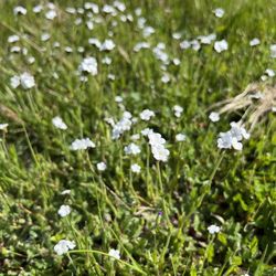
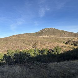
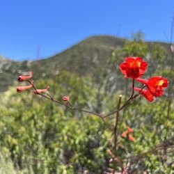
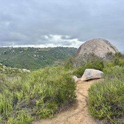
Reviews With Photos

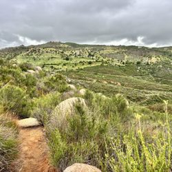
This may be a five star hike if you actually hike the 7.5 miles out-and-back to Mt. Gower. My family wanted no part of that on a hot August day so we chose a smaller trail in this preserve. Our trail was called the Western View Trail which is only 3 mile or so miles total. The trail wasn't the best in that the road was gravely and it wasn't the most picturesque. With the heat beaning down perhaps it was a bit too much. Recommendation - Unless you're a serious hiker, the Swartz Canyon Trail ( less than 2 miles total ) is you're best option especially with kids. - Lots of parking - Bathrooms
")
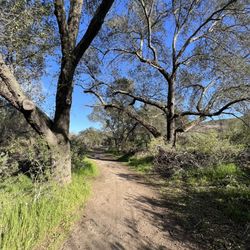
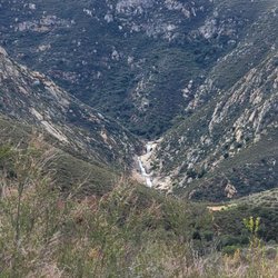
I can't believe more people don't know about this place - but I suppose the lack of crowds is part of the appeal. When I set out to hike the peak of Mount Gower, I couldn't find a whole lot of useful trail information. So, here it goes: Parking- There is a large lot if you follow Gunn Stage Rd all the way to the end and continue up the gravel road about .5 miles. Facilities- There is a restroom and water at the trail head Trail- Follow the main trail out of the parking area. After about a quarter mile the trail splits, stay to the right if you want to go to the peak. About a mile in, there is a trail that splits off to the right. This is just a vista point - we skipped it. The main trail will continue down into a drainage area, and then up towards the water tower. After the water tower you will continue up and down several rolling hills, until you cross over towards the base of Mt Gower. The main path continues up along the side of Mount Gower and ends at a beautiful vista point. To continue to the peak, it is pretty much a scramble up the last ~.5 miles. We followed a small path of foot prints from previous hikers up to the top. Distance- 7.7 miles r/t to the peak (according to my cell phone tracker) Difficulty- Moderate+, the length is probably the most difficult part of the hike. There are some steep uphill climbs, but they are usually short in duration.

1 year ago
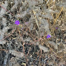
Beautiful trail! So much color after the recent rain. Not an easy hike, but it's worth the effort. Go early, and be mindful of your hydration needs. read more


2 years ago
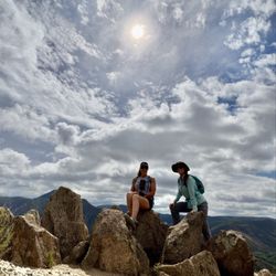
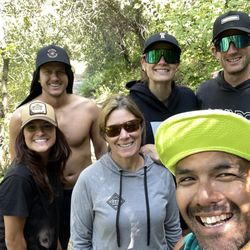
I'd give this trail a 4.5, based on the region. It certainly isn't a 4.5 compared to hikes in Yosemite, Hawaii, etc. ... but in San Diego, it definitely ranks up there as one of my favorites. Why I like this trail: - it is a fairly wide trail that is in excellent shape, with relatively few rocks to maneuver around (I'd still wear trail running shoes, but it seems a lot less ankle-twisty than Elfin Forest for instance). - the chaparral is relatively low, so one has good views and visibility throughout the hike. - it consists of a lot of ups and downs (much like El Cajon Mtn / El Capitan), so one not only gets variety - which I enjoy -, but there is also less continuous downhill pounding on one's knees (as would be the case when coming down Iron Mountain for instance). - the panoramic view from the top is pretty freagin spectacular! (granted, we are coming off a lot of rain this week, so we were probably treated to extra special views today); my 12 second video clip doesn't do it justice, but here it is: photos.app.goo.gl/bPR5cx... - because it is one of the more remote hikes in San Diego, there are very few people on the trail (during the entire roundtrip of 8miles, we encountered only 5 or 6 other sets of hikers.... nice!). A side benefit of fewer hikers is that the public restrooms at the trailhead were uber clean...especially compared to Iron Mountain's. Here are some things to know about the trail: -NO SHADE - WEATHER/TEMP MISLEADING: Immediately prior to driving there, weather.com said the days high would be 59 degrees in Ramona. My layers stayed in my backpack though, because it *felt* more like 75 to me (I've done this hike 4 times, and it has always felt 10 -15 degrees hotter there than weather.com / accuweather predicted). Definitely a hike to do on a cooler day, and definitely bring plenty of water. - DISTANCE AND ELEVATION: there are multiple entrances/exits, and that alone can make a huge a difference in D & E. Started at the trail entrance o the left/west of the public restrooms in the parking lot (fyi: the parking lot is open from 8am to sunset) and hiking to the peak is about 8miles and 2400 feet elevation gain. My wife finds this trail to be a slog, but I love it. - WHAT TO DO AT THE FORKS: No real signage on the trail, which is a bummer, because there are multiple forks. Have a trail map pre-downloaded on your phone (i.e. alltrails.com) so you know what to do at the forks. - ALTERNATE TRAIL ENTRY POINTS: 1) if you want to shorten your hike, park in the first parking lot (the one without the restrooms); that cuts 1/2 mile to a 1 mile off the entire hike. - PACK IT IN AND PACK IT OUT: Other than the trashcans and restrooms at the main entrance, there are no facilities or trashcans on the trail. - DOGS -- Dogs on leashes are allowed. Due to the extreme dearth of other hikers, we could see ahead in the distance that some owners would leave their dogs offleash until they came within several hundered feet of other hikers, at which point they would releash them. If bringing your dogs, make sure to bring your poop bags with you, and be prepared to carry them out for miles (BOS Amazing bags are life saving odor blockers for trails like this). read more


This may be a five star hike if you actually hike the 7.5 miles out-and-back to Mt. Gower. My family wanted no part of that on a hot August day so we chose a smaller trail in this preserve. Our trail was called the Western View Trail which is only 3 mile or so miles total. The trail wasn't the best in that the road was gravely and it wasn't the most picturesque. With the heat beaning down perhaps it was a bit too much. Recommendation - Unless you're a serious hiker, the Swartz Canyon Trail ( less than 2 miles total ) is you're best option especially with kids. - Lots of parking - Bathrooms read more


I can't believe more people don't know about this place - but I suppose the lack of crowds is part of the appeal. When I set out to hike the peak of Mount Gower, I couldn't find a whole lot of useful trail information. So, here it goes: Parking- There is a large lot if you follow Gunn Stage Rd all the way to the end and continue up the gravel road about .5 miles. Facilities- There is a restroom and water at the trail head Trail- Follow the main trail out of the parking area. After about a quarter mile the trail splits, stay to the right if you want to go to the peak. About a mile in, there is a trail that splits off to the right. This is just a vista point - we skipped it. The main trail will continue down into a drainage area, and then up towards the water tower. After the water tower you will continue up and down several rolling hills, until you cross over towards the base of Mt Gower. The main path continues up along the side of Mount Gower and ends at a beautiful vista point. To continue to the peak, it is pretty much a scramble up the last ~.5 miles. We followed a small path of foot prints from previous hikers up to the top. Distance- 7.7 miles r/t to the peak (according to my cell phone tracker) Difficulty- Moderate+, the length is probably the most difficult part of the hike. There are some steep uphill climbs, but they are usually short in duration. read more
 - Hiking Near Me - Ramona, California")
What a great hike! I found this location using the AllTrails app (which is a great app!) and decided to go this morning to think. The longest trail is 3.58 according to the map but my tracker said it was 4.2 so I'm not positive. This mountain is awesome and there was not one other person there! It is definitely a little harder than moderate though! read more


More info about Mt Gower County Preserve
Ask the Community - Mt Gower County Preserve
You might also consider


Mt Gower County Preserve - hiking - Updated July 2026
Best of Ramona
People found Mt Gower County Preserve by searching for…
Trending Searches in Ramona, CA
Browse Articles
Browse Nearby
BEST of Ramona, California Coffee near Mt Gower County Preserve
BEST of Ramona, California Restaurants near Mt Gower County Preserve
BEST of Ramona, California Things to Do near Mt Gower County Preserve
BEST of Ramona, California Breakfast near Mt Gower County Preserve
BEST of Ramona, California Parks near Mt Gower County Preserve
BEST of Ramona, California Horseback Riding near Mt Gower County Preserve
BEST of Ramona, California Campgrounds near Mt Gower County Preserve
Browse Brands
Related Searches in Ramona, CA
Affordable Kayak Rental Services in Ramona, California
Best Fishing Locations and Guides in Ramona, California
Best Nature Trails for Hiking in Ramona, California
Best Places for Horseback Riding in Ramona, California
Best Waterfalls and Swimming Holes in Ramona, California
Check Out Off Road Trails in Ramona, California
Discover Dog Friendly Trails to Explore in Ramona, California
Discover Scenic Hiking Trails in Ramona, California
Discover Scenic Mountain Bike Trails Near Ramona, California
Discover Walking Parks in Ramona, California Near You
Discover a Hiking Trail in Ramona, California
Discover the Best Night Hike Trails in Ramona, California
Dog-Friendly Hikes With Dogs in Ramona, California
Enjoy Camping Adventures Around Ramona, California
Enjoy Exciting Mountain Biking Adventures in Ramona, California
Enjoy Kayaking Adventures in Ramona, California
Enjoy Tent Camping Spots Around Ramona, California
Enjoy a Beautiful Waterfall Hike in Ramona, California
Enjoy a Peaceful Nature Walk in Ramona, California
Enjoy the Best Picnic Spots and Ideas in Ramona, California
Enjoy the Best Walking Path in Ramona, California
Enjoy the Best Walking Trails in Ramona, California
Exciting Cliff Jumping Spots in Ramona, California
Explore Beautiful Parks and Green Spaces in Ramona, California
Explore Easy Hikes Perfect for All in Ramona, California
Explore Fun Activities to Do in Ramona, California
Explore Popular Campgrounds Near Ramona, California
Explore the Best Beach Spots in Ramona, California
Explore the Best Trail Options in Ramona, California
Family Friendly Hiking With Kids in Ramona, California
Find Beautiful Views in Ramona, California
Find Popular Ziplining Spots Around Ramona, California
Find the Best Parks for Picnics in Ramona, California
Find the Best Scenic View Locations in Ramona, California
Great Places to Walk in Ramona, California
Hike the Popular Waterfall Trail in Ramona, California
Hiking Trails With Waterfalls in Ramona, California
Off Leash Dog Hiking Trails in Ramona, California
Popular Outdoor Activities to Try in Ramona, California
Popular Picnic Spots to Visit in Ramona, California
Safe River Swimming Areas in Ramona, California
Safe and Fun Parks for Kids in Ramona, California
Top Climbing Spots and Gyms in Ramona, California
Top Paddleboarding Activities in Ramona, California
Top Places for Snorkeling in Ramona, California
Top Running Trails to Explore in Ramona, California
Top Swimming Lakes to Enjoy in Ramona, California
Top Swimming Spots and Pools in Ramona, California
People who viewed Mt Gower County Preserve also viewed
Lake Poway Trail
64 reviews
Volcan Mountain Preserve
87 reviews
Barnett Ranch County Preserve
6 reviews
Devil's Jumpoff
4 reviews
Oakoasis County Preserve
19 reviews
Historic Flume Trailhead
2 reviews
Blossom Valley
Ramona Grasslands Preserve
20 reviews
Twin Peaks
13 reviews
Santa Ysabel Preserves
35 reviews
Chimney Rock Open Space Preserve
1 review