Eagle Cap Wilderness Photos


More like Eagle Cap Wilderness
Recommended Reviews - Eagle Cap Wilderness
Start your review...

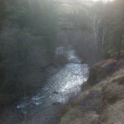
This review is for one of the Big Sheep Creek trails accessed by the NF-100 road off Wallowa Mountain Road (Loop). First off, Eagle Cap is a fabulous wilderness area. I love it and after this first time experience, we'll be back. That said, our hiking adventure was shorter than we'd planned because the creeks were still too high to allow all the several crossings necessary to do the several miles in that we wanted. We were too early in the season (late May). But we did get 2.6 miles of hiking in and enjoyed every bit of it. Fantastic scenery. The access road wasn't too bad even in a Toyota Corolla, although we were stopped by snow a few hundred yards short of the trailhead, Not that many critters, though. Highly recommended. read more


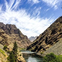
Nestled in the far northeast corner of Oregon lies a magical land of awe-inspiring mountain peaks, alpine lakes filled with jumping trout, beautifully vibrant meadows, and miles upon miles of trails. This place doesn't get the love & press of it's northern neighbor, The Enchantments (Washington's Cascadian alpine wonderland), but I would argue this outdoor area is just as good....or dare I say: better? [[[[bracing myself for tomatoes and trash to be thrown at me]]]] OK, I'm only saying it's "better" because it's in more of a remote area (so less traffic), and you don't need to worry about measuring your luck with a permit lottery (it's probably not needed due to less traffic). So this place is definitely more approachable. The Eagle Cap Wilderness is a huge area (almost 600 square miles). It's still new to me, but in 2015, I had the pleasure of spending two trips up here, one in July & the other in Sept. It is an expansive area, but I would say, obviously enough, that Eagle Cap peak is the hub of the area. From Eagle Cap, you have spokes of mountain ranges and river valleys. There are several approaches to get you from lower elevations to the alpine region around Eagle Cap. For my first experience, we went for a less-traveled approach from the south: Eagle Creek Valley. The solitude here is surely something I daydream about, but I would have to say the 4th of July weekend has some brutally hot weather--especially when hiking uphill. We camped one night in this valley and made it over Horton Pass to a camp up in the alpine area for a couple of nights. While at Horton Pass, I took a side trip up to summit Eagle Cap. The views here were life-changing. MOSQUITO HEAVEN: July in Eagle Cap Wilderness was hot and there were mosquitoes up the ying yang! It as pretty unbearable. I slept in a bivy sack, and I cooked in it as the mosquitoes tried stealing my blood as they peered in at me through the face screen. Sleep was tough. But during the day, it was great to have day hikes around the area, jump in clear & cold lakes and to also wet a fly while pursuing trout. Fall is my preference though. In September we did an approach from the north and hiked up the East Lostine River Valley. Once you get above 5000, there is a long glacial valley which is just about the most beautiful place I've ever seen. Hiking this valley was surreal. The peaceful stream, the beautiful color of the vegetation, and Eagle Cap looking over us the whole time: perfect hiking! There's no mosquitoes at all, but the days are short. The weather is a little chilly, so no chance of taking a dip in the Lostine River. But it was pretty nice. The Lostine River approach is also an easier hike, too. You don't have to hike over a mountain pass. And you can pretty much get up to the alpine area after a few hours of hiking. read more


10 years ago
Pristine, gorgeous! it's a do not miss backpacking trip if you get this in your lifetime! Will return hopefully in the near future! A lot of people use this trail .. As well as horses. read more


8 years ago
10 years ago
More info about Eagle Cap Wilderness
Lostine, OR 97857
Directions
Visit Website
http://www.eaglecapwilderness.com
Hours
Outdoor Amenities


Eagle Cap Wilderness - hiking - Updated June 2026
Best of Lostine
People found Eagle Cap Wilderness by searching for…
Campgrounds in Lostine, Oregon
Things to Do in Lostine, Oregon
Hiking Trails in Lostine, Oregon
Places to Take Pictures in Lostine, Oregon
Off Road Trails in Lostine, Oregon
Camping Cabins in Lostine, Oregon
Beautiful Views in Lostine, Oregon
Camping Sites in Lostine, Oregon
Things to Do at Night in Lostine, Oregon
Hiking With Kids in Lostine, Oregon
Walking Trails in Lostine, Oregon
Parks for Kids in Lostine, Oregon
Lakes & Ponds in Lostine, Oregon
Tent Camping in Lostine, Oregon
Secret Spots in Lostine, Oregon
Photo Spots in Lostine, Oregon
Scenic View in Lostine, Oregon
Nature Parks in Lostine, Oregon
Scenic Drive in Lostine, Oregon
Browse Articles
Browse Nearby
Browse Brands
Related Searches in Lostine, OR
Best Lookout Points to Visit in Lostine, Oregon
Best Nature Trails for Hiking in Lostine, Oregon
Best Places for Stunning Views in Lostine, Oregon
Check Out Off Road Trails in Lostine, Oregon
Discover Scenic Creeks to Explore in Lostine, Oregon
Discover Top Boat Tours in Lostine, Oregon for All Ages
Discover Top Nature Parks to Visit in Lostine, Oregon
Discover a Hiking Trail in Lostine, Oregon
Discover the Best Night Hike Trails in Lostine, Oregon
Dog-Friendly Hikes With Dogs in Lostine, Oregon
Enjoy the Best Night View Spots in Lostine, Oregon
Enjoy the Best Walking Trails in Lostine, Oregon
Experience Stunning Sunset Views in Lostine, Oregon
Explore Popular Scenic Overlook Points in Lostine, Oregon
Explore the Best Trail Options in Lostine, Oregon
Family Friendly Hiking With Kids in Lostine, Oregon
Find Beautiful Views in Lostine, Oregon
Find the Best Scenic View Locations in Lostine, Oregon
Plan a Scenic Drive Route Near Lostine, Oregon
Safe River Swimming Areas in Lostine, Oregon