South Fork Walla Walla River Trailhead Photos


More like South Fork Walla Walla River Trailhead
Recommended Reviews - South Fork Walla Walla River Trailhead
Start your review...

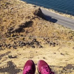
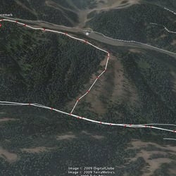
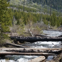
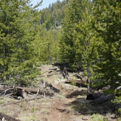
This hike happened by happenstance. A friend and I were supposed to go up to Horseshoe Prairie (http://www.yelp.com/biz/horseshoe-prairie-nordic-ski-area-pendleton) for snowshoeing, but unfortunately, I let my friend drive and he was a little too confident about his car's snowy-road-handling ability. After spinning tires a time or two, we canned our fun-in-the-snow plans, turned around, and slid down the hill to civilization. While picking up chocolates at Petite Noirs (http://www.yelp.com/biz/petits-noirs-milton-freewater), the owner mentioned a nearby hike. To not make the day a total loss, we were all ears, and went for it. Just off of main street in Milton Freewater, you take the turn off for Harris Park (as you're driving south out of town, it'll be the left BEFORE you take the hill up and out of town). You then drive about 10 miles up a canyon carved by the South Fork of the Walla Walla River. This canyon is part of the Blue Mountains, and it's amazing to see how quickly the landscape changes from the drabby flatness of Milton-Freewater to the alpine-y beauty of the Blues & Walla Walla river. Once you're in the area of the park, keep going until you approach the trailhead for the South Fork Walla Walla River trail. Here there are quite a few parking spots, a couple of restrooms and river bubbles within earshot. You are clearly outside of civilization and within an honest to goodness country landscape. The deep valley is beautiful and the trail looks inviting. For the most part the trail parallels the river. Sometimes it sidetracks and goes up the side of the valley wall, but the river is always within view. The trail is well-kept and nice (other than a few boggy/muddy spots). We went for about 2.5 miles on the trail before calling it a day. We enjoyed sightings of elk at one spot (we later saw herds of deer, turkey, and even a scooting coyote during our dusk drive out). I'm so glad I made it here. I can definitely see myself coming back to dip myself within the magic waters (à la Field of Dreams) and fly fishing the stream (à la A River Runs Through It). I've also heard that you can ride your mountain bike here too---I'd also be down for that! South Fork of the Walla Walla Trail. I will see you again---very, very soon. read more


7 years ago
This was a great hike with my dog. Very turn their was a beautiful view of the Walla walla River. Trail was in decent condition. Plenty of parking at the trailhead. read more
More info about South Fork Walla Walla River Trailhead


South Fork Walla Walla River Trailhead - hiking - Updated May 2026
Best of Milton-Freewater
People found South Fork Walla Walla River Trailhead by searching for…
Things to Do in Milton-Freewater, OR
Fishing in Milton-Freewater, OR
Hiking Trails in Milton-Freewater, OR
Beautiful Views in Milton-Freewater, OR
Off Road Trails in Milton-Freewater, OR
Running Trails in Milton-Freewater, OR
Walking Trails in Milton-Freewater, OR
Mountain Biking in Milton-Freewater, OR
Things to Do at Night in Milton-Freewater, OR
Fishing Spots in Milton-Freewater, OR
Places to Take Pictures in Milton-Freewater, OR
Scenic View in Milton-Freewater, OR
Waterfalls in Milton-Freewater, OR
Tourist Attractions in Milton-Freewater, OR
Scenic Spots in Milton-Freewater, OR
Scenic Restaurants in Milton-Freewater, OR
River Walk in Milton-Freewater, OR
Trending Searches in Milton-Freewater, OR
Bounce House Rentals near South Fork Walla Walla River Trailhead
Campgrounds near South Fork Walla Walla River Trailhead
Floral Designers near South Fork Walla Walla River Trailhead
Flower Shop near South Fork Walla Walla River Trailhead
Mexican Catering near South Fork Walla Walla River Trailhead
Nurseries & Gardening near South Fork Walla Walla River Trailhead
Party Equipment Rentals near South Fork Walla Walla River Trailhead
Browse Articles
Browse Nearby
Browse Brands
Related Searches in Milton-Freewater, OR
Best Fishing Locations and Guides in Milton-Freewater, Oregon
Best Fun Things to Do in Milton-Freewater, Oregon
Best Places for Horseback Riding in Milton-Freewater, Oregon
Best Places for Stunning Views in Milton-Freewater, Oregon
Check Out Off Road Trails in Milton-Freewater, Oregon
Discover Top Boat Tours in Milton-Freewater, Oregon for All Ages
Discover the Best Fishing Lake in Milton-Freewater, Oregon
Discover the Best Running Track in Milton-Freewater, Oregon
Enjoy Camping Adventures Around Milton-Freewater, Oregon
Enjoy the Best Night View Spots in Milton-Freewater, Oregon
Explore Beautiful Parks and Green Spaces in Milton-Freewater, Oregon
Explore Free Things to Do Around Milton-Freewater, Oregon
Explore Fun Activities to Do in Milton-Freewater, Oregon
Explore Popular Campgrounds Near Milton-Freewater, Oregon
Explore Popular RV Parks Around Milton-Freewater, Oregon
Explore Popular View Points Around Milton-Freewater, Oregon
Explore Scenic Lakes to Visit in Milton-Freewater, Oregon
Explore the Best Boating Spots in Milton-Freewater, Oregon
Family Friendly Hiking With Kids in Milton-Freewater, Oregon
Find Cozy Camping Cabins in Milton-Freewater, Oregon
Find Fun Kids Activities Outdoor in Milton-Freewater, Oregon
Find Top-Rated Disc Golf in Milton-Freewater, Oregon
Find the Best Playgrounds to Visit in Milton-Freewater, Oregon
Locate Tennis Courts Around Milton-Freewater, Oregon
Must-See Tourist Attractions Around Milton-Freewater, Oregon
Popular Kids Activities in Milton-Freewater, Oregon
Popular Picnic Spots to Visit in Milton-Freewater, Oregon
Popular Places to Take Pictures in Milton-Freewater, Oregon
Popular Things to Do in Milton-Freewater, Oregon
Popular Things to See in Milton-Freewater, Oregon
Relax at Natural Hot Springs Near Milton-Freewater, Oregon
Safe and Fun Parks for Kids in Milton-Freewater, Oregon
Top RV Campgrounds to Visit in Milton-Freewater, Oregon
Top Running Trails to Explore in Milton-Freewater, Oregon
People who viewed South Fork Walla Walla River Trailhead also viewed
Mid Columbia River Guide Service
1 review
Fort Walla Walla Park
1 review
Emigrant Springs State Park
16 reviews
Fort Walla Walla Dog Park
12 reviews
Horseshoe Prairie Nordic Ski Area
2 reviews
Roy Raley Park
3 reviews
Fort Walla Walla Disc Golf Course
2 reviews
Murr Sports Field
1 review
Wine Valley Golf Club Maintenance
1 review
Enable Art
2 reviews