Twin Sisters Rock Photos


More like Twin Sisters Rock
Recommended Reviews - Twin Sisters Rock
Start your review...

Reviews With Photos

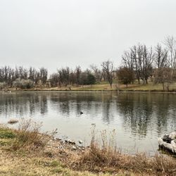
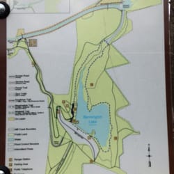
You'll see the sisters watching over you on your left before you even arrive to the small pull-off with enough space for just a few cars, on your left, off of the SR 730. (Here's the link to the Google Map: http://bit.ly/1QeHUFz) Once you've parked, you'll note a sign sharing the Two Sisters Legend. The legend weaves the tale of two Cayuse Indian sisters who were turned into these large basalt pillars by a crafty Coyote, who had fallen in love with them, but was also a notorious trickster. A third sister, was ultimately turned into a cave downstream, and he himself turned into a rock, so that he could watch over them forever (romantic, right?). Climb through the wide gap in the barbed wire fence, or over the wooden "ladder" to the right, to access the trail. The trail fans out in a few directions, and it's clear that one leads directly to the base of the Twin Sisters, while others lead to lookout points on either side. The hike itself is short in any direction, but there are steep sections with loose gravel, so one should still watch their footing. The reward at the top of each area is a gorgeous vista of the Columbia River and the Wallula Gap. If it weren't for the highway with the occasional semitruck cruising by directly below, one could almost imagine that they were further out in the wilderness. It's a great little jaunt off the side of the road - perfect if you're short on time and ready for some nearly-immediate gratification.

The gravel parking lot is right off the side of the road, and I originally drove past it without realizing that was the lot. So, I had to turn around and drive back, which was slightly nerve-wracking as the highway has some twists and turns that make it difficult to tell if there is oncoming traffic. On the plus side, there seems to be plenty of room for parking, and we were the only ones there. There's a sign detailing the legend of the twin sisters, and then there's a short but steep trail to the base of the rocks. Great place to stretch your legs! read more


10 months ago
Beautiful site. Easy trail. A bit more difficult incline. Enjoyed it. Turning off the road was not as difficult as they say. Just prepare ahead of time warning drivers behind you. Several people did come flying in like bats out of hell but there is no need for that. read more
My place. I found my place. To the top, it's a short while. From the moment I exited my car to the moment I reached the top of twin rocks, it was 8 minutes. It almost felt like a waste to cut out 3 hours of my day for this. In hindsight, every reviewer said on Yelp how short this hike is. So heads up, folks. This is not even half a mile. But again, I found my place. It was dead silent at the top other than the howling wind, and I found solace. I pulled out my book, found a ledge, and started reading. Time passed and not a single soul came by. It's truly unlike any other hike I've done where I see people often. Cherry on top: I could never get sick of that gorgeous view. Dangerous as it might be for solo hikers (you could die or get hurt there and not be discovered for a while), it's definitely worth a visit. read more


10 years ago
You'll see the sisters watching over you on your left before you even arrive to the small pull-off with enough space for just a few cars, on your left, off of the SR 730. (Here's the link to the Google Map: http://bit.ly/1QeHUFz) Once you've parked, you'll note a sign sharing the Two Sisters Legend. The legend weaves the tale of two Cayuse Indian sisters who were turned into these large basalt pillars by a crafty Coyote, who had fallen in love with them, but was also a notorious trickster. A third sister, was ultimately turned into a cave downstream, and he himself turned into a rock, so that he could watch over them forever (romantic, right?). Climb through the wide gap in the barbed wire fence, or over the wooden "ladder" to the right, to access the trail. The trail fans out in a few directions, and it's clear that one leads directly to the base of the Twin Sisters, while others lead to lookout points on either side. The hike itself is short in any direction, but there are steep sections with loose gravel, so one should still watch their footing. The reward at the top of each area is a gorgeous vista of the Columbia River and the Wallula Gap. If it weren't for the highway with the occasional semitruck cruising by directly below, one could almost imagine that they were further out in the wilderness. It's a great little jaunt off the side of the road - perfect if you're short on time and ready for some nearly-immediate gratification. read more


7 years ago
About a 30 minute drive from Kennewick. Got there about 4:30 and just in time to catch a beautiful sunset. I was the only person there so it was very peaceful and quiet other than trucks on the road. The views were amazing and you only have to walk up for less than 10 minutes to reach a good viewing area. I just went up to that area and back down obviously because it was getting dark but I definitely plan to go back soon to explore some of the other trails. read more


8 years ago
More info about Twin Sisters Rock
Ask the Community - Twin Sisters Rock


Twin Sisters Rock - hiking - Updated May 2026
Best of Touchet
People found Twin Sisters Rock by searching for…
Browse Articles
Browse Brands
Related Searches in Touchet, WA
Best Fishing Locations and Guides in Touchet, Washington
Check Out Great Playgrounds in Touchet, Washington
Check Out Off Road Trails in Touchet, Washington
Discover Fun Activities to Do in Touchet, Washington
Enjoy the Best Night View Spots in Touchet, Washington
Explore Fun Activities to Do in Touchet, Washington
Explore Kid Friendly Places and Events in Touchet, Washington
Explore Landmarks & Historical Buildings in Touchet, Washington
Explore Popular RV Parks Around Touchet, Washington
Explore Popular View Points Around Touchet, Washington
Explore Summer Camps for All Ages in Touchet, Washington
Explore Top Gyms in Touchet, Washington Now
Family Friendly Hiking With Kids in Touchet, Washington
Find Top-Rated Disc Golf in Touchet, Washington
Locate Tennis Courts Around Touchet, Washington
Must-See Tourist Attractions Around Touchet, Washington
Popular Kids Activities in Touchet, Washington
Popular Places to Take Pictures in Touchet, Washington
Top Hiking Trails to Explore in Touchet, Washington
Trending Searches in Touchet, WA
Baseball Fields near Twin Sisters Rock
Boat Rental near Twin Sisters Rock
Bounce House Rentals near Twin Sisters Rock
Campgrounds near Twin Sisters Rock
Cheap Plants near Twin Sisters Rock
Dog Friendly Things To Do near Twin Sisters Rock
Floral Designers near Twin Sisters Rock
Flower Shop near Twin Sisters Rock
Garage Sales near Twin Sisters Rock
Nurseries & Gardening near Twin Sisters Rock
Outdoor Activities near Twin Sisters Rock
Outdoor Furniture Stores near Twin Sisters Rock
Party Equipment Rentals near Twin Sisters Rock
Pedicure near Twin Sisters Rock
Pick Your Own Farms near Twin Sisters Rock
Picnic Areas near Twin Sisters Rock
Picnic Spots near Twin Sisters Rock
Places To Take Pictures near Twin Sisters Rock
Plant Nursery near Twin Sisters Rock
Public Beaches near Twin Sisters Rock
Running Trails near Twin Sisters Rock
Scenic Drive near Twin Sisters Rock
Swimming Holes near Twin Sisters Rock
Tennis Courts near Twin Sisters Rock