Blue Mountains Trails Photos


More like Blue Mountains Trails
Recommended Reviews - Blue Mountains Trails
Start your review...

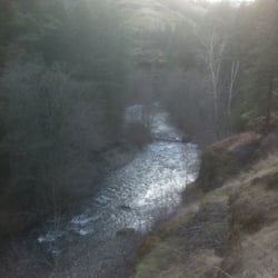
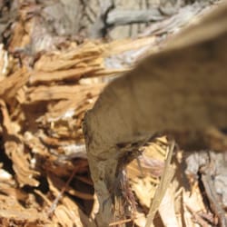
These trails aren't just for winter sports. I've made it here during the summer to take my mountain bike for a ride. I parked at the Sno-Park Parking lot where one would go during the winter months. Here you have a couple of dirt roads to choose from for off-road options. I decided to do some climbing and went for NFD Rd 64--to get to this road from the parking lot, ride your bike further up the valley a few hundred yards (their's a trail), and then take right. This road is fairly nice. There are lots of rock on it, but no potholes. It is a fairly uphill jaunt from the get-go. As I was approaching the top of the valley, I eyed a side road. The sign on it said (6400 500), so I don't know which is the name of the road, but I decided to take it, because it looked tiny and way less traveled (in fact it was closed to motorized vehicles). Nice. Yeah, this trail ended up being the high-point of the day. It wasn't single track, but it was close. I must admit I had the willies when I saw a half-eaten deer leg within the first minute of climbing (the rest of the ride I kept thinking of the cougar, bear, or zombie which was eyeing me from the bushes as I rode by). I love to climb. I love burning my quads like Hades. It felt good to be riding. Unfortunately, this side road only lasted a little bit before I made it up to the top of the ridge/mountain. Here this trail ties back up with one of the major dirt roads again. There are some decent views here. I then took the little road downhill. Man, I'm must be a total old fogie, because wow---I think I rode the breaks the entire way down! The road was steep, and I hit some high speeds within seconds. There were also rocks to watch out for as well. In other words, I rode it like an old person (which I am I suppose). But it was fun. It's the kind of fun, where you just have to yell with abandon (I think I did a few times--with a smile). These trails are definitely good for snow activities, and I'd say they are decent for bike riding. I don't know if I'd come here to do some straight-up hiking though. I'd save the Cascades for that. NOTE: Be careful on this road in the winter. This is the infamous scene of where my truck and my crew rolled down a mountain just over a year ago! read more

More info about Blue Mountains Trails
corner of NFD 64 Rd & NFD 650 Rd
Dayton, WA 99328
Directions
Hours
Outdoor Amenities


Blue Mountains Trails - hiking - Updated July 2026
Best of Dayton
People found Blue Mountains Trails by searching for…
Things to Do in Dayton, Washington
Hiking Trails in Dayton, Washington
Beautiful Views in Dayton, Washington
Places to Take Pictures in Dayton, Washington
Off Road Trails in Dayton, Washington
Walking Trails in Dayton, Washington
View Points in Dayton, Washington
Running Trails in Dayton, Washington
Parks for Kids in Dayton, Washington
Mountain Biking in Dayton, Washington
Must See in Dayton, Washington
Dog Walking Areas in Dayton, Washington
Scenic View in Dayton, Washington
Photo Spots in Dayton, Washington
Fun Things to Do at Night in Dayton, Washington
Waterfalls in Dayton, Washington
River Swimming in Dayton, Washington
Fishing Spots in Dayton, Washington
Dog Friendly Trails in Dayton, Washington
Off Leash Dog Hikes in Dayton, Washington
Trending Searches in Dayton, WA
Day Trips near Blue Mountains Trails
Fishing Spots near Blue Mountains Trails
Lakes near Blue Mountains Trails
Off Road Trails near Blue Mountains Trails
River Swimming near Blue Mountains Trails
Sunrise View near Blue Mountains Trails
Swimming Holes near Blue Mountains Trails
Browse Articles
Browse Brands
Related Searches in Dayton, WA
Affordable Long Term RV Parking in Dayton, Washington
Best Fishing Locations and Guides in Dayton, Washington
Best Fun Things to Do in Dayton, Washington
Best Lookout Points to Visit in Dayton, Washington
Best Places for Horseback Riding in Dayton, Washington
Best Places for Stunning Views in Dayton, Washington
Best Spots for Star Gazing in Dayton, Washington
Check Out Off Road Trails in Dayton, Washington
Discover Popular Photo Spots in Dayton, Washington
Discover Top Boat Tours in Dayton, Washington for All Ages
Enjoy Camping Adventures Around Dayton, Washington
Enjoy the Best Night View Spots in Dayton, Washington
Explore Beautiful Parks and Green Spaces in Dayton, Washington
Explore Popular Campgrounds Near Dayton, Washington
Explore Popular RV Parks Around Dayton, Washington
Explore Scenic Lakes to Visit in Dayton, Washington
Explore the Best Boating Spots in Dayton, Washington
Family Friendly Hiking With Kids in Dayton, Washington
Find Beautiful Views in Dayton, Washington
Find Cozy Camping Cabins in Dayton, Washington
Find the Best Playgrounds to Visit in Dayton, Washington
Locate Tennis Courts Around Dayton, Washington
Plan a Scenic Drive Route Near Dayton, Washington
Popular Kids Activities in Dayton, Washington
Popular Picnic Spots to Visit in Dayton, Washington
Popular Places to Take Pictures in Dayton, Washington
Popular Things to Do in Dayton, Washington
Popular Things to See in Dayton, Washington
Relax at Natural Hot Springs Near Dayton, Washington
Safe and Fun Parks for Kids in Dayton, Washington
Top Places to Visit in Dayton, Washington for Sightseeing
Top Running Trails to Explore in Dayton, Washington
Top Swimming Spots and Pools in Dayton, Washington