Juniper Dunes Wilderness Photos


More like Juniper Dunes Wilderness
Recommended Reviews - Juniper Dunes Wilderness
Start your review...

2 years ago
The terrain here is unique to ride. The ancient riverbed makes for a course feel to the sand. Mixed with the various plants, very manageable, even on a smaller motorcycle. The open bowl areas have deeper sand. Not too many huge razorbacks that could be hazardous. Good spot right after a light rain. read more


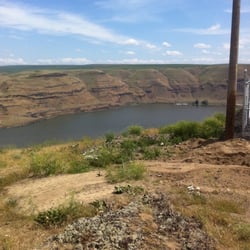
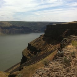
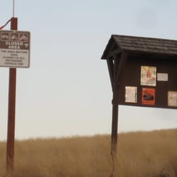
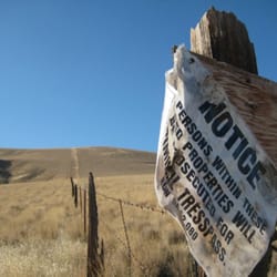
Yes, I came close to murdering my dogs on this hike, and I had visions of cool watery mirages while thinking I could easily suffer from dehydration and forever lose myself within the maze of dunes ad nauseum, but I still have to give this place 5-stars! --I can't blame Juniper Dunes for MY being ill-prepared. --I can't blame Juniper Dunes for a wonderful spring day (first 80+degF day of the year) which gave me a sunburn. --I can't blame Juniper Dunes for my packing one measly bottle of water to be shared amongst the three of us animals (my two dogs & I). --And I can't blame Juniper Dunes for being so cool as to make you want to keep hiking & hiking & hiking & hiking Juniper Dunes Wilderness is such a cool desert-y treasure, and it's less than an hours drive from the Tri-Cities. I don't know the whole political backstory of the area, but I do know it's been a bit elusive. The land is a protected Federal wilderness area. However, it's virtually surrounded by private land--this makes access a bit touchy. All the trips I've made here have been via the northern trailhead. The best way to get here from the Tri-Cities is to take the Pasco-Kahlotus Highway east (check out the google map on here). The drive out is through farmlands. During my recent drive I saw Asparagus was being harvested (mmm!), an old single-room school, and also several of the biggest mailboxes I've ever seen (musta been a farm thing--I should have snapped a photo of 'em). You take a gravel road as your almost near the trailhead, and then approach a nice Welcome sign for the area (see attached). The trailhead is near paddock for cows, so the moo-moo's will definitely check you out as you approach. You will also see a nice sign with rules about the Wilderness (for those using this access point)---the main thing to note is that this entrance is only open from March - May. Since this is a protected area (it's fenced all-around), a really good thing is that you won't see any of those pesky off-road vehicles in here--none of their scarring tracks or piercing howls. Within about 5-10min of hiking one will quickly escape the drudgery of farmlands, cows and tractors and be enveloped by silent sandy beauty. There is quite a bit of vegetation, but the sand dunes are clearly evident. The sand workout you get will slap you upside the face quick. You will also begin to see your first Junipers (this area is known for having the northernmost grove of Juniper pines). This is a rough hike, but it's so worth it. Now if you were more prepared, you'd have a really good time. For me, I spent half the time worrying about rationing our water pathetic single bottle of water. My furry friends were too furry and thirsty to make a trudge like this. I felt like such a bad poppa as they were struggling toward the end of the hike. But yeah, it's a really cool hike. You are surrounded by farmland, but as you dip up and down sand dunes you quickly forget civilization in the silence. In April there were many types of wildflowers in bloom--think of pinks, bright purples, & golden yellows. There was also something which emitted the sweetest aroma---I wish I could bottle it! All in all a great hike! * BRING WATER * PUT ON SUN TAN LOTION * BE PREPARED FOR A SANDY WORKOUT * MAYBE LEAVE DOGGIES HOME * YOU ONLY HAVE FROM MARCH - MAY **** And most importantly: HAVE FUN OUT THERE! **** read more


6 years ago
More info about Juniper Dunes Wilderness
Kahlotus Hwy
Pasco, WA 99302
Directions
(509) 536-1200
Call Now
Hours
Outdoor Amenities


Juniper Dunes Wilderness - hiking - Updated June 2026
Best of Pasco
People found Juniper Dunes Wilderness by searching for…
Things to Do in Pasco, Washington
Off Road Trails in Pasco, Washington
Hiking Trails in Pasco, Washington
Photo Spots in Pasco, Washington
Hiking With Kids in Pasco, Washington
Beautiful Views in Pasco, Washington
Walking Trails in Pasco, Washington
Running Trails in Pasco, Washington
Waterfalls in Pasco, Washington
Jogging Trails in Pasco, Washington
Tourist Attractions in Pasco, Washington
Bike Paths in Pasco, Washington
River Swimming in Pasco, Washington
Off Leash Dog Hikes in Pasco, Washington
Fun Places to Go in Pasco, Washington
Things to See in Pasco, Washington
Things to Do at Night in Pasco, Washington
Fishing Spots in Pasco, Washington
Splash Pad in Pasco, Washington
Trending Searches in Pasco, WA
Boat Rental near Juniper Dunes Wilderness
Day Trips near Juniper Dunes Wilderness
Fishing Spots near Juniper Dunes Wilderness
Fruit Picking near Juniper Dunes Wilderness
Kayak Rental near Juniper Dunes Wilderness
Lakes near Juniper Dunes Wilderness
Outdoor Activities near Juniper Dunes Wilderness
Pick Your Own Farms near Juniper Dunes Wilderness
Places To Swim near Juniper Dunes Wilderness
Pool Supplies near Juniper Dunes Wilderness
Public Shower near Juniper Dunes Wilderness
Public Swimming Pools near Juniper Dunes Wilderness
River Swimming near Juniper Dunes Wilderness
Running Trails near Juniper Dunes Wilderness
Scenic Drive near Juniper Dunes Wilderness
Splash Pad near Juniper Dunes Wilderness
Browse Articles
Browse Brands
Related Searches in Pasco, WA
Affordable Kayak Rental Services in Pasco, Washington
Best Fishing Locations and Guides in Pasco, Washington
Best Fun Things to Do in Pasco, Washington
Best Off Leash Dog Parks in Pasco, Washington
Best Places for Horseback Riding in Pasco, Washington
Best Places for Stunning Views in Pasco, Washington
Check Out Off Road Trails in Pasco, Washington
Discover Scenic Waterfall Spots in Pasco, Washington
Discover Top Boat Tours in Pasco, Washington for All Ages
Discover a Hiking Trail in Pasco, Washington
Discover the Best Running Track in Pasco, Washington
Enjoy Exciting Mountain Biking Adventures in Pasco, Washington
Enjoy Tent Camping Spots Around Pasco, Washington
Enjoy the Best Night View Spots in Pasco, Washington
Enjoy the Best Walking Trails in Pasco, Washington
Experience Stunning Sunset Views in Pasco, Washington
Explore Beautiful Parks and Green Spaces in Pasco, Washington
Explore Bike Rentals Throughout Pasco, Washington
Explore Free Things to Do Around Pasco, Washington
Explore Fun Activities to Do in Pasco, Washington
Explore Popular Campgrounds Near Pasco, Washington
Explore Popular RV Parks Around Pasco, Washington
Explore Popular View Points Around Pasco, Washington
Explore Scenic Lakes to Visit in Pasco, Washington
Explore Top Dog Parks in Pasco, Washington Near You
Explore Top Water Parks in Pasco, Washington Today
Explore the Best Boating Spots in Pasco, Washington
Family Friendly Hiking With Kids in Pasco, Washington
Find Beautiful Views in Pasco, Washington
Find Cozy Camping Cabins in Pasco, Washington
Find Fun Things to Do With Kids in Pasco, Washington
Find Top Dog Swimming Spots in Pasco, Washington
Find Top-Rated Disc Golf in Pasco, Washington
Find the Best Parks for Picnics in Pasco, Washington
Find the Best Playgrounds to Visit in Pasco, Washington
Find the Best Swimming Pools in Pasco, Washington Today
Great Places to Swim in Pasco, Washington
Have Fun at a Splash Pad in Pasco, Washington
Locate a Public Shower Facility in Pasco, Washington
Popular Kids Activities in Pasco, Washington
Popular Outdoor Activities to Try in Pasco, Washington
Popular Places to Take Pictures in Pasco, Washington
Popular Things to Do in Pasco, Washington
Relax at Natural Hot Springs Near Pasco, Washington
Safe River Swimming Areas in Pasco, Washington
Safe and Fun Parks for Kids in Pasco, Washington
Top Playgrounds for Kids to Enjoy in Pasco, Washington
Top Running Trails to Explore in Pasco, Washington