Horseshoe Prairie Nordic Ski Area Photos


More like Horseshoe Prairie Nordic Ski Area
Recommended Reviews - Horseshoe Prairie Nordic Ski Area
Start your review...

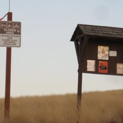
I've been on a Nordic kick as of late. To feed a fix, I ventured two hours south to the Oregon hills (known as "The Blues"). My drive down was a little angst-ridden because we've been experiencing downright tropical weather for this winter thus far. The entire drive to the base of The Blues did not embolden me with hope. In fact for the first 10 miles up the mountain--nary a patch of snow was spied. But then. Before I knew it. Batches of the white stuff sprung from the woodwork. I like it when nature is a tease. The stress of no snow then switched to the stress of snow driving (it wasn't that bad, but snow driving has that effect on me now.). I drove through the Nordic-ish wonderland for another 10-15 miles. I knew not what I was looking for, but for most of the drive I had cell phone coverage and gps (so I was able to Yelp Check-In). Then I was there: Andies Prairie Sno-Park. Yes, I DID NOT see a sign for Horseshoe Prairie, but my research said this was the joint. I entered the parking lot at the ENTRANCE (important for later!) and parked near the entrance near the restroom. I saw a small sign mentioning Horseshoe Prairie near the restroom, but no info on where to go. Other than a snow-mobile group, I was the only other car in the parking lot (yes, it's a Sno-Park, so you need a Sno-Park permit). I knew Horseshoe Prairie Nordic Ski Area was adjacent to Andies Prairie, but I knew not where. So I walked back out to the main road. I saw a break in the cut snowbank on the other side of the road. This is where someone climbed over the snow and started snowshoeing. "Is this it?!" I thought to myself. I went ahead and connected to my skis (not trivial, I spent a good 15 min trying to get hooked up & cursing to the snow Gods). I then just followed the snowshoe trail. It didn't look good. I trudged along clumsily. I then started a text conversation with a friend to ask, in effect, "Is this it?!" At some point turned around (the snowshoe path lead into a dense forrest area). My friend texted that there were Blue markers to look for. I went back near the road and then skied DOWN the road for a bit. Nothing. I then skied UP the road (and when i say "skied", I really mean walking with skis. I wasn't very elegant-looking to the drivers laughing at me when they zoomed by. But then the sun shone down. I found it: Horseshoe Prairie Nordic Ski Area!! Yup, I found the "trailhead" for the ski area! There's a big brown & white sign here (not easily seen from the road. I should say that this entrance to the ski area is visible from the EXIT of the Sno-Park lot (so if I didn't find it, the sign would have laughed at my stupidity as I left). I was super-excited. So, I jumped on a trail and was off. Man, there's nothing like moving with Nordic skis. It's a great work out, and you can get moving. Now the trails aren't groomed, but enough people use this area that you can probably find a decent track to slip into. Daylight was fading, so I made a quick workout of the trail. I stuck to a main path. I wasn't sure where I was going. I hoped I was on a loop. 45-60min later, my loop returned to the trailhead. It was a nice trip. The trail was nice for my novice skills. I did notice a lot of offshoot tracks. So you can make what you want of this area. It's wild, and it's nice. I can't wait to explore more (now that I know where to go!). read more


15 years ago
More info about Horseshoe Prairie Nordic Ski Area
2517 SW Hailey Ave
Pendleton, OR 97801
Directions
(541) 278-3716
Call Now
Hours
Outdoor Amenities


Horseshoe Prairie Nordic Ski Area - hiking - Updated May 2026
Best of Pendleton
People found Horseshoe Prairie Nordic Ski Area by searching for…
Trending Searches in Pendleton, OR
Bounce House Rentals near Horseshoe Prairie Nordic Ski Area
Campgrounds near Horseshoe Prairie Nordic Ski Area
Floral Designers near Horseshoe Prairie Nordic Ski Area
Flower Shop near Horseshoe Prairie Nordic Ski Area
Mexican Catering near Horseshoe Prairie Nordic Ski Area
Nurseries & Gardening near Horseshoe Prairie Nordic Ski Area
Parks near Horseshoe Prairie Nordic Ski Area
Party Equipment Rentals near Horseshoe Prairie Nordic Ski Area
Pedicure near Horseshoe Prairie Nordic Ski Area
Places To Take Pictures near Horseshoe Prairie Nordic Ski Area
River Swimming near Horseshoe Prairie Nordic Ski Area
Running Trails near Horseshoe Prairie Nordic Ski Area
Browse Articles
Browse Brands
Related Searches in Pendleton, OR
Best Fishing Locations and Guides in Pendleton, Oregon
Best Fun Things to Do in Pendleton, Oregon
Best Nature Trails for Hiking in Pendleton, Oregon
Best Places for Stunning Views in Pendleton, Oregon
Best Waterfalls and Swimming Holes in Pendleton, Oregon
Check Out Off Road Trails in Pendleton, Oregon
Discover Baseball Fields Around Pendleton, Oregon
Discover Popular Bike Trails in Pendleton, Oregon
Discover a Hiking Trail in Pendleton, Oregon
Discover the Best Night Hike Trails in Pendleton, Oregon
Enjoy Camping Adventures Around Pendleton, Oregon
Enjoy Exciting Mountain Biking Adventures in Pendleton, Oregon
Enjoy Tent Camping Spots Around Pendleton, Oregon
Enjoy the Best Walking Trails in Pendleton, Oregon
Experience Stunning Sunset Views in Pendleton, Oregon
Explore Beautiful Parks and Green Spaces in Pendleton, Oregon
Explore Bike Rentals Throughout Pendleton, Oregon
Explore Fun Activities to Do in Pendleton, Oregon
Explore Nature Spots Around Pendleton, Oregon
Explore Popular Campgrounds Near Pendleton, Oregon
Explore Popular RV Parks Around Pendleton, Oregon
Explore Scenic Lakes to Visit in Pendleton, Oregon
Explore Top Dog Parks in Pendleton, Oregon Near You
Explore Top Water Parks in Pendleton, Oregon Today
Explore the Best Boating Spots in Pendleton, Oregon
Explore the Best Trail Options in Pendleton, Oregon
Family Friendly Hiking With Kids in Pendleton, Oregon
Find Beautiful Views in Pendleton, Oregon
Find Fun Things to Do With Kids in Pendleton, Oregon
Find the Best Parks for Picnics in Pendleton, Oregon
Find the Best Playgrounds to Visit in Pendleton, Oregon
Find the Best Swimming Pools in Pendleton, Oregon Today
Great Places to Swim in Pendleton, Oregon
Locate a Public Shower Facility in Pendleton, Oregon
Off Leash Dog Hiking Trails in Pendleton, Oregon
Plan a Scenic Drive Route Near Pendleton, Oregon
Popular Kids Activities in Pendleton, Oregon
Popular Picnic Spots to Visit in Pendleton, Oregon
Popular Places to Take Pictures in Pendleton, Oregon
Popular Things to Do in Pendleton, Oregon
Popular Things to See in Pendleton, Oregon
Relax at Natural Hot Springs Near Pendleton, Oregon
Safe River Swimming Areas in Pendleton, Oregon
Safe and Fun Parks for Kids in Pendleton, Oregon
Top Paddleboarding Activities in Pendleton, Oregon
Top Running Trails to Explore in Pendleton, Oregon
Top Swimming Spots and Pools in Pendleton, Oregon
Top Things to Do With Kids in Pendleton, Oregon