Park At the River Photos


More like Park At the River
Recommended Reviews - Park At the River
Start your review...

2 months ago
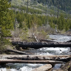
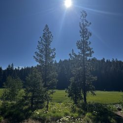
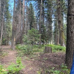
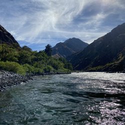
The staff are friendly, the park is tidy, and it's located in a beautiful and very convenient to everything the Wallowa mountains offer. While it's right in the center of town, there are a number of sites that offer great mountain views, along with the relaxing sounds of the Wallowa River rushing along the edge of the park can make you feel as if you are there all alone. We've stayed there 3 years in a row, and couldn't be happier. However, do note that they do not allow dogs. You might see a couple during your stay, but they are "grandfathered" in because the policy went into effect last year. Longtime guests with pets that have proven to be well behaved do have doggie rights. Personally, we love the policy. While we like dogs, too many un-trained pets and clueless dog owners have led to troubling incidents forcing the owners to exclude them. If you have a dog, skip this park. We've not stayed in the cabins on site, but they look to be very comfortable as well. read more


1 year ago
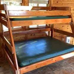
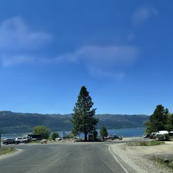
Well located, by River, near food and activities including miniature golf, tram, and go karts, and very shaded and well maintained. We caught a last minute opening to stay in the Cabin by the River. To be honest it's cabin-like but it's set up to be a meeting, maybe wedding, like venue, so I would clarify it's missing that charm. Nonetheless, it's hard to fault it for being too roomy. The setting is great, particularly the deck. It's a studio, but big enough my wife could sleep while I hung out and not wake her. I might lean 4 stars, but am going 5 because other complaints about this place do not justify the 1 Star rating, as few places here allow dogs, are no cheaper, and don't have grounds as nice or as well maintained, so my fifth Star helps balance. read more
11 months ago
2 years ago
2 years ago
6 years ago
3 years ago
5 years ago
6 years ago
6 years ago
6 years ago
4 years ago
9 years ago
9 years ago
More info about Park At the River
59888 Wallowa Lake Hwy
Joseph, OR 97846
Directions
(541) 432-8800
Call Now
Visit Website
http://www.parkattheriver.com
Hours
Outdoor Amenities
From the Business
Ask the Community - Park At the River
Review Highlights - Park At the River


Why does Yelp recommend reviews?
2 reviews that are not currently recommended
The reviews below are not factored into the business's overall star rating.
1 year ago
2 years ago
Park At the River - parks - Updated July 2026
Best of Joseph
People found Park At the River by searching for…
Things to Do With Kids in Joseph, Oregon
Places to Swim in Joseph, Oregon
Rv Campgrounds in Joseph, Oregon
Camping Sites in Joseph, Oregon
Playgrounds for Kids in Joseph, Oregon
Hiking Trails in Joseph, Oregon
Places to Take Pictures in Joseph, Oregon
Public Shower in Joseph, Oregon
Fishing Spots in Joseph, Oregon
Beautiful Views in Joseph, Oregon
Walking Trails in Joseph, Oregon
Camping Cabins in Joseph, Oregon
Parks for Kids in Joseph, Oregon
River Swimming in Joseph, Oregon
Picnic Spots in Joseph, Oregon
Trending Searches in Joseph, OR
Browse Articles
Browse Nearby
BEST of Joseph, Oregon Coffee near Park At the River
BEST of Joseph, Oregon Things to Do near Park At the River
BEST of Joseph, Oregon Restaurants near Park At the River
BEST of Joseph, Oregon Shopping near Park At the River
BEST of Joseph, Oregon Breakfast near Park At the River
BEST of Joseph, Oregon Lodging near Park At the River
Browse Brands
Related Searches in Joseph, OR
Affordable Kayak Rental Services in Joseph, Oregon
Best Fishing Locations and Guides in Joseph, Oregon
Best Places for Horseback Riding in Joseph, Oregon
Best Places for Stunning Views in Joseph, Oregon
Best Things to Do on a Rainy Day in Joseph, Oregon
Best Waterfalls and Swimming Holes in Joseph, Oregon
Check Out Off Road Trails in Joseph, Oregon
Discover Popular Photo Spots in Joseph, Oregon
Discover Top Nature Parks to Visit in Joseph, Oregon
Discover the Best Night Hike Trails in Joseph, Oregon
Enjoy Scenic Night View Experiences in Joseph, Oregon
Enjoy Tent Camping Spots Around Joseph, Oregon
Enjoy the Best Night View Spots in Joseph, Oregon
Enjoy the Best Picnic Spots and Ideas in Joseph, Oregon
Enjoy the Best Tubing Experiences in Joseph, Oregon
Experience Stunning Sunset Views in Joseph, Oregon
Explore Free Things to Do Around Joseph, Oregon
Explore Nature Spots Around Joseph, Oregon
Explore Popular Picnic Areas Around Joseph, Oregon
Explore Popular View Points Around Joseph, Oregon
Explore Scenic Lakes to Visit in Joseph, Oregon
Explore Secret Spots Worth Visiting in Joseph, Oregon
Explore Top Gyms in Joseph, Oregon Now
Explore the Best Trail Options in Joseph, Oregon
Family Friendly Hiking With Kids in Joseph, Oregon
Find Beautiful Views in Joseph, Oregon
Find Fun Kids Activities Outdoor in Joseph, Oregon
Great Places to Swim in Joseph, Oregon
Plan a Scenic Drive Route Near Joseph, Oregon
Popular Outdoor Activities to Try in Joseph, Oregon
Popular Places to Take Pictures in Joseph, Oregon
Popular Things to Do in Joseph, Oregon
Popular Things to See in Joseph, Oregon
Relax at Natural Hot Springs Near Joseph, Oregon
Top Fishing Charter Experiences in Joseph, Oregon
Top Hiking Trails to Explore in Joseph, Oregon
Top Must See Attractions and Spots in Joseph, Oregon
Top Places to Visit in Joseph, Oregon for Sightseeing
Top Running Trails to Explore in Joseph, Oregon
Top Swimming Spots and Pools in Joseph, Oregon
Top Things to Do With Kids in Joseph, Oregon
Top-Rated Boat Rental Services in Joseph, Oregon
People who viewed Park At the River also viewed
Catherine Creek State Park
1 review
Hells Canyon Overlook
3 reviews
Wallowa Lake State Park
22 reviews
Wallowa Lake
4 reviews
Wallowa Lake Pack Station
7 reviews
Winding Waters River Expeditions
13 reviews
Hells Canyon Adventures
27 reviews
Tributary Whitewater
11 reviews
Eagle Cap Wilderness Outfitters
2 reviews
Twenty One Feet
1 review