Ye Olde School Trail Photos


More like Ye Olde School Trail
Recommended Reviews - Ye Olde School Trail
Start your review...

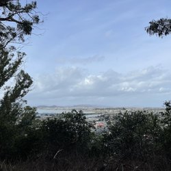
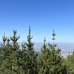
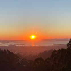
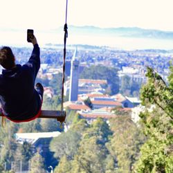
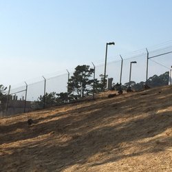
This hidden fire trail is only a half-mile long and probably only familiar to the local residents who maintain it, but it's worth checking out if you happen to be in Kensington Park. It starts on the side of Kensington Elementary School and follows an unexpected ridge on the edge of Tilden Regional Park (photo: http://bit.ly/2ReJxqU). I didn't expect it to be so bucolic, scenic, and full of dog walkers, but there you are. The trail ends right where Grizzly Peak Blvd. starts or vice versa depending on where you find the trail. I'm sure there must be a cute story behind the name, but don't look at me. I just walk it for the extra steps and the view. RELATED - Up for a hike? Here are the places around the Bay Area where I have trod: bit.ly/2OsCCsK read more


3 years ago
13 years ago
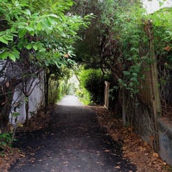
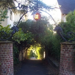
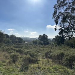
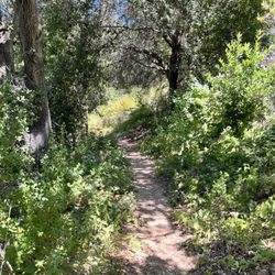
There comes a time in your life when you just need to get away from the noise. I found that profoundly beautiful solitude in the enchanted pathways of Ye Olde School Trail. I've known about this fire trail for quite some time and knew that it was not on Yelp. I suppose I wanted to keep it secret from the world as my own private sanctuary. However, I trust you, my reader, to show the same respect that I do to this peaceful trail. There are two entrances to the trail, one from Grizzly Peak Blvd. & Kenyon Ave. and the other from behind the Kensington Hilltop Elementary School. I will lead you through the trail, starting with the elementary school entrance. On one side you will be greeted with a magnificent view of the San Francisco Bay, while the other side boasts dry lands with scrubby, low-lying bushes scattered throughout. There are large power trestles along the gentle slopes of the dry lands, interspersed with dense clumps of old growth trees. As you meander further on the fire trail, you will hear the sighs of tall, rustling oaks and eucalyptus. I even saw a large hawk of some sort soaring gracefully overhead. You may find yourself in the company of friendly folks walking their dogs or playing with their children, but everyone is quiet and respectful within this sun-dappled sanctuary from the city. Enjoy this little piece of heaven, just on the northern edge of Berkeley. If you need some time to contemplate, this is just the right place for it. read more

More info about Ye Olde School Trail
Grizzly Peak Blvd & Kenyon Ave
Kensington, CA 94708
Directions
Hours
Outdoor Amenities


Ye Olde School Trail - hiking - Updated July 2026
Best of Kensington
People found Ye Olde School Trail by searching for…
Hiking Trails in Kensington, CA
Scenic Places to Walk in Kensington, CA
Things to Do in Kensington, CA
Dog Friendly Hiking Trails in Kensington, CA
Walking Trails in Kensington, CA
Secret Spots in Kensington, CA
Off Leash Dog Hiking Trails in Kensington, CA
Beautiful Views in Kensington, CA
Hikes With Dogs in Kensington, CA
Running Trails in Kensington, CA
Parks for Kids in Kensington, CA
Scenic Spots in Kensington, CA
Walking Groups in Kensington, CA
Regional Parks in Kensington, CA
Trending Searches in Kensington, CA
Blueberry Picking near Ye Olde School Trail
Boating near Ye Olde School Trail
Cliff Jumping near Ye Olde School Trail
Cruising Spots near Ye Olde School Trail
Day Trips near Ye Olde School Trail
Dog Friendly Things To Do near Ye Olde School Trail
Flower Fields near Ye Olde School Trail
Jet Skis near Ye Olde School Trail
Kayak Rental near Ye Olde School Trail
Kids Activities Indoor near Ye Olde School Trail
Lakes near Ye Olde School Trail
Lookout Points near Ye Olde School Trail
Off Road Trails near Ye Olde School Trail
Outdoor Activities near Ye Olde School Trail
Parks near Ye Olde School Trail
Peach Picking near Ye Olde School Trail
River Swimming near Ye Olde School Trail
Rock Quarry near Ye Olde School Trail
Scenic Overlook near Ye Olde School Trail
Sunrise View near Ye Olde School Trail
Surf Shop near Ye Olde School Trail
Swimming Holes near Ye Olde School Trail
Things To Do On A Rainy Day near Ye Olde School Trail
U Pick Farms near Ye Olde School Trail
Watch Sunset near Ye Olde School Trail
Browse Articles
Browse Nearby
BEST of Kensington, California Coffee near Ye Olde School Trail
BEST of Kensington, California Restaurants near Ye Olde School Trail
BEST of Kensington, California Things to Do near Ye Olde School Trail
BEST of Kensington, California Walking Trails near Ye Olde School Trail
BEST of Kensington, California Parks near Ye Olde School Trail
BEST of Kensington, California Breakfast near Ye Olde School Trail
BEST of Kensington, California Campgrounds near Ye Olde School Trail
BEST of Kensington, California Day Trips near Ye Olde School Trail
BEST of Kensington, California Lodging near Ye Olde School Trail
Browse Brands
Related Searches in Kensington, CA
Affordable Kayak Rental Services in Kensington, California
Best Dog Hiking Trails Around Kensington, California
Best Fishing Locations and Guides in Kensington, California
Best Nature Trails for Hiking in Kensington, California
Best Places for Horseback Riding in Kensington, California
Check Out Off Road Trails in Kensington, California
Discover Dog Friendly Trails to Explore in Kensington, California
Discover Easy Hiking Trails Near Kensington, California
Discover Kid Friendly Hiking Trails in Kensington, California
Discover Popular Bike Trails in Kensington, California
Discover a Hiking Trail in Kensington, California
Discover the Best Night Hike Trails in Kensington, California
Dog-Friendly Hikes With Dogs in Kensington, California
Enjoy Camping Adventures Around Kensington, California
Enjoy Kayaking Adventures in Kensington, California
Enjoy Off Leash Dog Hikes in Kensington, California
Enjoy Scenic Places to Walk in Kensington, California
Enjoy a Beautiful Waterfall Hike in Kensington, California
Enjoy the Best Picnic Spots and Ideas in Kensington, California
Enjoy the Best Walking Path in Kensington, California
Enjoy the Best Walking Trails in Kensington, California
Experience Stunning Sunset Views in Kensington, California
Explore Beautiful Parks and Green Spaces in Kensington, California
Explore Easy Hikes Perfect for All in Kensington, California
Explore Fun Activities to Do in Kensington, California
Explore Popular Campgrounds Near Kensington, California
Explore Popular Dog Walking Trails in Kensington, California
Explore Top Dog Parks in Kensington, California Near You
Explore the Best Beach Spots in Kensington, California
Family Friendly Hiking With Kids in Kensington, California
Find Beautiful Views in Kensington, California
Find Top Dog Friendly Parks to Visit in Kensington, California
Find Top-Rated Waterfalls in Kensington, California Now
Find the Best Parks BBQ Grills in Kensington, California
Find the Best Parks for Picnics in Kensington, California
Hiking Trails With Waterfalls in Kensington, California
Off Leash Dog Hiking Trails in Kensington, California
Plan a Scenic Drive Route Near Kensington, California
Popular Outdoor Activities to Try in Kensington, California
Popular Picnic Spots to Visit in Kensington, California
Safe River Swimming Areas in Kensington, California
Safe and Fun Parks for Kids in Kensington, California
Top Dog Friendly Things to Do in Kensington, California
Top Hiking Trails to Explore in Kensington, California
Top Playgrounds for Kids to Enjoy in Kensington, California
Top Running Trails to Explore in Kensington, California
Top Swimming Lakes to Enjoy in Kensington, California
Top Swimming Spots and Pools in Kensington, California
Walk Dog Friendly Hiking Trails in Kensington, California
Walk the Best Paved Walking Trails in Kensington, California
People who viewed Ye Olde School Trail also viewed
Cragmont Park
15 reviews
Berkeley Hills
Hillside Natural Area
16 reviews
Veterans Memorial Park
18 reviews
Grotto Rock Park
6 reviews
Berkeley Hills
Berkeley Path Wanderers Association
3 reviews
Berkeley Hills
Shimada Friendship Park
21 reviews
Brickyard Cove and Uplands
7 reviews
West Berkeley
Pinole Creek Trail
9 reviews
Barbara and Jay Vincent Park
21 reviews
Tilden Regional Park and Environmental Educatn Ctr
9 reviews