Nicholl Knob Photos


You might also consider
More like Nicholl Knob
Recommended Reviews - Nicholl Knob
Start your review...

Reviews With Photos

Beautiful trail. You can't beat a nice hike with amazing views. This trail is challenging but definitely doable. There are about 2 sections of incline that are especially difficult but the remainder of the hike is pretty much a breeze. Throughout the trail, you can see vies of the water and Richmond-San Rafael bridge. You always may be lucky enough to see deer! There's also plenty of parking across the street and even right in front of the trail which is a huge plus.

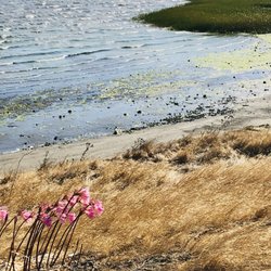
In this El Niño year, it's getting tougher & tougher to get outside for exercise without getting really wet &/or muddy. Sometimes the window of opportunity between storms, when the ground gets the slightest chance to dry out, is tiny & brief. As much as I'm aware of the dire drought situation, & am happy for all the rainfall, I am starting to miss trail running. Fortunately, I recently got around to checking out Nicholl Knob. It's the nearby neighborhood hill that I've seen out the windows of my place for years. During drier times, the scenic beauty of Marin's hills, mountains, & redwoods are my usual trail running tromping grounds. But, right about now, convenience is key to getting any time on the trail at all. & for that, Nicholl Knob has been an ideal backyard trail running training ground. It's not huge or vast. But what it lacks in height & trail mileage, it makes up for with angle & intensity. There's a few stretches of trail that are very steep & there's some spots with really technical surface conditions. Parking is always easy & I've yet to see it crowded up there. For a quick fix, I've plotted a 2-mile trail loop with plenty of vertical. If I want more mileage, I'll run a 2nd lap. With Nicholl Knob being near the end of land jutting into the bay & no other high ground around it, the views at the top all around on a clear day are quite stunning. &, again, best of all, for me, is the convenience of such a great place so close to home. Oh, & shout out to Jana C. for finding, exploring, & Yelping Nicholl Knob so long ago. I don't know what took me so long discovering the nearby neighborhood hill & all its trails, but I'll be back often.

It is simply stunning! Did some good, respectable hiking on another gorgeous 70'sF day. Hiking with 360 degree views of the East Bay...those Potrero Hills can seriously kick those glutes and quads into overdrive.. this seemingly simple hill manned by East Bay Regional parks is often overlooked as a way to capture some glorious sights of all 3 bay bridges, and wonderful Angel Island, as well as Tiburon. Such a wonderful little secret, this treasure is located just across the street from Miller Knox, trailhead accessible by Dorman Dr. There are great trail names like Marine View trail, Crest Trail, East Ridge Trail.... depending on which hill you hike, you'll see very detailed vistas of the Chevron refinery and the Berkeley Hills and northward, or you can switch over to the west side, and it's all glorious blue!!!! Dirt paths, mainly with some harder rock along the way...some trails are downright steeper than others, so head down and power through it, keeping your weight in the right place! The breeze was always there to cool us, so it was lovely. Very few spots on the various trails have shade, and often times, may have some non-posion oak wild flowers brush against your shin. Awesome way to get some fresh air, exercise, and appreciate the jewel that this area is...A great itinerary may be to tour the SS Red Oak victory and then hike some, and have a quaint lunch in historic downtown Point Richmond. If you've a family, the Golden State model Railroad Museum is also here, but check their spotty hours. Full models of railroad lines for kids (and trainspotters) to enjoy! From here, I shuffled over to San Quentin Village, and then over to San Rafael.


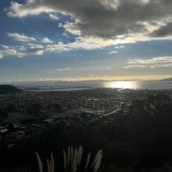
"Up there we see everything, Oakland to the left, El Cerrito and Richmond to the right, Marin forward, over the Bay, Berkeley below, all red rooftops and trees of cauliflower and columbine, shaped like rockets and explosions, all those people below us, with humbler views; we see the Bay Bridge, clunkety, the Richmond Bridge, straight, low, the Golden Gate, red toothpicks and string, the blue between, the blue above, the gleaming white Land of the Lost/Superman's North Pole Getaway magic crystals that are San Francisco." -Dave Eggers This wasn't written for Nicholl's Knob but you will see breathtaking views here as well. It's a simple little hike, up a few intense hills but the views are well worth it. It will take you about an hour if you stop for pics. You can do another hour on the Bay at Knox Regional across the street. Not many folks on the hills and I doubt that will ever change. A lovely hidden gem. read more


2 years ago
Beautiful trail. You can't beat a nice hike with amazing views. This trail is challenging but definitely doable. There are about 2 sections of incline that are especially difficult but the remainder of the hike is pretty much a breeze. Throughout the trail, you can see vies of the water and Richmond-San Rafael bridge. You always may be lucky enough to see deer! There's also plenty of parking across the street and even right in front of the trail which is a huge plus. read more


In this El Niño year, it's getting tougher & tougher to get outside for exercise without getting really wet &/or muddy. Sometimes the window of opportunity between storms, when the ground gets the slightest chance to dry out, is tiny & brief. As much as I'm aware of the dire drought situation, & am happy for all the rainfall, I am starting to miss trail running. Fortunately, I recently got around to checking out Nicholl Knob. It's the nearby neighborhood hill that I've seen out the windows of my place for years. During drier times, the scenic beauty of Marin's hills, mountains, & redwoods are my usual trail running tromping grounds. But, right about now, convenience is key to getting any time on the trail at all. & for that, Nicholl Knob has been an ideal backyard trail running training ground. It's not huge or vast. But what it lacks in height & trail mileage, it makes up for with angle & intensity. There's a few stretches of trail that are very steep & there's some spots with really technical surface conditions. Parking is always easy & I've yet to see it crowded up there. For a quick fix, I've plotted a 2-mile trail loop with plenty of vertical. If I want more mileage, I'll run a 2nd lap. With Nicholl Knob being near the end of land jutting into the bay & no other high ground around it, the views at the top all around on a clear day are quite stunning. &, again, best of all, for me, is the convenience of such a great place so close to home. Oh, & shout out to Jana C. for finding, exploring, & Yelping Nicholl Knob so long ago. I don't know what took me so long discovering the nearby neighborhood hill & all its trails, but I'll be back often. read more


It is simply stunning! Did some good, respectable hiking on another gorgeous 70'sF day. Hiking with 360 degree views of the East Bay...those Potrero Hills can seriously kick those glutes and quads into overdrive.. this seemingly simple hill manned by East Bay Regional parks is often overlooked as a way to capture some glorious sights of all 3 bay bridges, and wonderful Angel Island, as well as Tiburon. Such a wonderful little secret, this treasure is located just across the street from Miller Knox, trailhead accessible by Dorman Dr. There are great trail names like Marine View trail, Crest Trail, East Ridge Trail.... depending on which hill you hike, you'll see very detailed vistas of the Chevron refinery and the Berkeley Hills and northward, or you can switch over to the west side, and it's all glorious blue!!!! Dirt paths, mainly with some harder rock along the way...some trails are downright steeper than others, so head down and power through it, keeping your weight in the right place! The breeze was always there to cool us, so it was lovely. Very few spots on the various trails have shade, and often times, may have some non-posion oak wild flowers brush against your shin. Awesome way to get some fresh air, exercise, and appreciate the jewel that this area is...A great itinerary may be to tour the SS Red Oak victory and then hike some, and have a quaint lunch in historic downtown Point Richmond. If you've a family, the Golden State model Railroad Museum is also here, but check their spotty hours. Full models of railroad lines for kids (and trainspotters) to enjoy! From here, I shuffled over to San Quentin Village, and then over to San Rafael. read more


7 years ago
If you like a challenge when hiking or just a simple jog, this is the right trail for you. Great views and few shaded areas to take a breather. The difficult rate for this trail would probably be a solid 7.5 . Most in part by how long the trail is, also it's pretty rocky so be very careful when running, easily could lose your footing. read more


9 years ago
14 years ago
More info about Nicholl Knob
900 Dornan Dr
Richmond, CA 94801
Directions
Hours
Outdoor Amenities
Ask the Community - Nicholl Knob
Review Highlights - Nicholl Knob
You might also consider


Nicholl Knob - hiking - Updated July 2026
Best of Richmond
People found Nicholl Knob by searching for…
Trending Searches in Richmond, CA
Black Owned Nail Salons near Nicholl Knob
Cliff Jumping near Nicholl Knob
Jet Ski Rental near Nicholl Knob
Kayak Rental near Nicholl Knob
Lakes & Ponds near Nicholl Knob
Off Road Trails near Nicholl Knob
Outdoor Activities near Nicholl Knob
Picnic Spots near Nicholl Knob
Places To Swim near Nicholl Knob
Places To Walk Around near Nicholl Knob
Pool Day Pass near Nicholl Knob
Public Pools near Nicholl Knob
Public Shower near Nicholl Knob
River Swimming near Nicholl Knob
River Tubing near Nicholl Knob
Running Trails near Nicholl Knob
Scenic Night View near Nicholl Knob
Scenic Overlook near Nicholl Knob
Soccer Store near Nicholl Knob
Sunrise View near Nicholl Knob
Swimming Holes near Nicholl Knob
Swimming Lakes near Nicholl Knob
Browse Articles
Browse Nearby
BEST of Richmond, California Coffee near Nicholl Knob
BEST of Richmond, California Walking Trails near Nicholl Knob
BEST of Richmond, California Restaurants near Nicholl Knob
BEST of Richmond, California Things to Do near Nicholl Knob
BEST of Richmond, California Parks near Nicholl Knob
Browse Brands
Related Searches in Richmond, CA
Affordable Kayak Rental Services in Richmond, California
Best Fishing Locations and Guides in Richmond, California
Best Nature Trails for Hiking in Richmond, California
Best Places for Horseback Riding in Richmond, California
Check Out Off Road Trails in Richmond, California
Discover Dog Friendly Trails to Explore in Richmond, California
Discover Kid Friendly Hiking Trails in Richmond, California
Discover Scenic Hiking Trails in Richmond, California
Discover Scenic Mountain Bike Trails Near Richmond, California
Discover Scenic Waterfall Spots in Richmond, California
Discover Top Nature Parks to Visit in Richmond, California
Discover Walking Parks in Richmond, California Near You
Discover a Hiking Trail in Richmond, California
Discover the Best Night Hike Trails in Richmond, California
Dog-Friendly Hikes With Dogs in Richmond, California
Enjoy Camping Adventures Around Richmond, California
Enjoy Kayaking Adventures in Richmond, California
Enjoy Tent Camping Spots Around Richmond, California
Enjoy a Beautiful Waterfall Hike in Richmond, California
Enjoy a Peaceful Nature Walk in Richmond, California
Enjoy the Best Picnic Spots and Ideas in Richmond, California
Enjoy the Best Walking Path in Richmond, California
Enjoy the Best Walking Trails in Richmond, California
Explore Beautiful Parks and Green Spaces in Richmond, California
Explore Easy Hikes Perfect for All in Richmond, California
Explore Fun Activities to Do in Richmond, California
Explore Popular Campgrounds Near Richmond, California
Explore the Best Beach Spots in Richmond, California
Explore the Best Swimming Holes Around Richmond, California
Explore the Best Trail Options in Richmond, California
Family Friendly Hiking With Kids in Richmond, California
Find Beautiful Views in Richmond, California
Find the Best Parks for Picnics in Richmond, California
Find the Best Scenic View Locations in Richmond, California
Great Places to Walk in Richmond, California
Hike the Popular Waterfall Trail in Richmond, California
Hiking Trails With Waterfalls in Richmond, California
Off Leash Dog Hiking Trails in Richmond, California
Plan a Scenic Drive Route Near Richmond, California
Popular Outdoor Activities to Try in Richmond, California
Popular Picnic Spots to Visit in Richmond, California
Safe River Swimming Areas in Richmond, California
Safe and Fun Parks for Kids in Richmond, California
Top Climbing Spots and Gyms in Richmond, California
Top Paddleboarding Activities in Richmond, California
Top Running Trails to Explore in Richmond, California
Top Swimming Lakes to Enjoy in Richmond, California
Top Swimming Spots and Pools in Richmond, California