Motorcycle Hill Photos


You might also consider
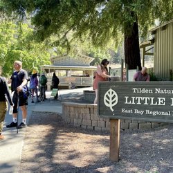
More like Motorcycle Hill
Recommended Reviews - Motorcycle Hill
Start your review...

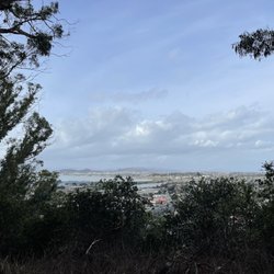
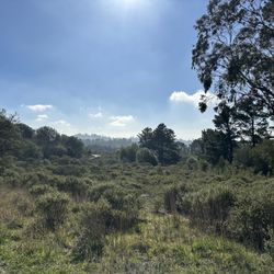
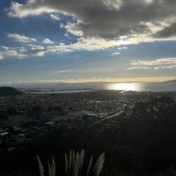
** The following review reflects my experience DURING the COVID-19 pandemic. ** It's actually not that hard to imagine the motorcycle hill climb races that took place here nearly a century ago. The surprise is how this steep escarpment remained untouched by real estate developers given how suburban this part of El Cerrito feels. I keep picturing that scene in "The Great Escape" where Steve McQueen jumped the POW camp fence as a testosterone-driven act of Nazi defiance. He would've ended up on somebody's backyard deck or in a hopefully filled swimming pool if he tried it now. You can get there from the bottom of the hill on the sorta corner of Navallier and Blake where you see a little staircase and a flyer posted on the fence about the hill's history. Or alternatively, you can take the hidden hillside stairs of El Cerrito and enter at the top through the nondescript path from Potrero Avenue. From the entrance, the first segment affords you a wide foot trail and a panoramic view of the bay (photo: https://bit.ly/2PI6CXp). The hillside trail itself is rustic in either direction with a lot of tall grass and dead trees that look like they were cut and left there for years. And yet, the constant views of El Cerrito make it a more pleasurable experience than you would expect despite the unexpected appearance of immobile wild turkeys (photo: https://bit.ly/3kO4wAM). RELATED - Up for a hike? Here's a collection of trails I've walked and reviewed: https://bit.ly/2OrC8nU read more


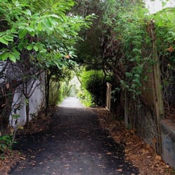
A hiking trail that's perfect for both uphill and downhill hiking, Motorcycle Hill just proves trails can not only exist just about anywhere there is public land but it also proves that trails can be created at anytime thanks to the fortitude and creative energy of a group of community nature lovers. In this case Motorcycle Hill was founded by El Cerrito Trail Trekkers, which was formed in order to build, maintain, publicize and use the little known urban trails of El Cerrito, California and they not only lead local trail hikes for community members to participate in and explore but their main goal is to create new safe trails in safe open spaces so all can enjoy and make sure that paths continue to be cleared of excess brush so the fire danger remains low, which in this day and time is remarkable we've been so lucky in our hillside neighborhood. I've have been to Motorcycle Hill about six times and every time I venture downhill (notice not uphill because I'm no fool as I still have to walk all the way home!) and I get to experience something interesting and new every time I venture along Potrero Avenue high in the hills of El Cerrito to begin my trek each and every time. If you're not careful you will miss the start of the trail from the top of the hill each and every times as it literally is a slim dirt pathway in between two single-level homes. Once you keep walking along the dirt path and see a huge swath of small cactuses growing like bushes to your left, you know you are on the right path. From there you keeping walking straight along a dirt path which I believe was created much longer than the rest of the trail as it hugs the hillside until you hit what is basically a naturally-made observation area that looks over the entire cities of El Cerrito and Richmond and you would see it all if it weren't for the numerous eucalyptus trees blocking your view line. From there you will notice a nice wooden handrail that serves as your starting point and barrier for where you are supposed to walk next, down Motorcycle Hill. which is a series of small switchback dirt trails down the steep incline (hence the name Motorcycle Hill and dirt bikes tend to do this as they head downhill as well). And I do mean steep as you can tell this remains a fairly new trail that hasn't been traveling along by a vast number of trekkers as there remains a long of brush and dirt which can get in the way for a smooth trip down the hill. And just be careful because it can be a trip down this hill, as many a time I found myself slipping to the point where I had to grab on to a tree or even the dirt below to make sure I wasn't rolling down the steep hill. And beware of your shoes as they're going to get really dirty as even on a warm day after walking back and forth down the incline, my shoes were filthy of dry brown dirt. But that's just one of the sacrifices one makes when walking down one of El Cerrito's newest trails. Once you're done you'll find yourself among a number of eucalyptus trees that has been cut down to their stumps on the back side of some residences and then you'll once again find yourself in between a narrow pathway in between two homes, this time on Blake Street. Then you're back in the suburban community from where you once came with passing cars whizzing by. But for a little while, you will be as grateful as I was for this tiny and tranquil oasis among all of the chaotic suburban city life. At Motorcycle Hill, one can enjoy a healthy hike with scenic views of San Francisco Bay and beyond, and we have the El Cerrito Trail Trekkers to thank for all of this. read more


4 years ago
Beautiful views, switch back upward trail through grass hill sides and foresty parts. Peaceful, quiet nature. read more


8 years ago
Moderate short switchback trail ending with sweeping views of the Bay. No parking available. Requires some knowledge of the local terrain to access. read more

More info about Motorcycle Hill
El Cerrito, CA 94530
Directions
Visit Website
http://ectrailtrekkers.org
Hours
Outdoor Amenities
You might also consider


Motorcycle Hill - hiking - Updated August 2026
Best of El Cerrito
People found Motorcycle Hill by searching for…
Hiking Trails in El Cerrito, CA
Dirt Bike Riding in El Cerrito, CA
Waterfall Hike in El Cerrito, CA
Beautiful Views in El Cerrito, CA
Sunrise View in El Cerrito, CA
Walking Trails in El Cerrito, CA
Scenic Spots in El Cerrito, CA
Scenic Places to Walk in El Cerrito, CA
Secret Spots in El Cerrito, CA
Swimming Lakes in El Cerrito, CA
Redwood Trees in El Cerrito, CA
Urban Exploration in El Cerrito, CA
Scenic Overlook in El Cerrito, CA
Off Road Trails in El Cerrito, CA
Blackberry Picking in El Cerrito, CA
Running Trails in El Cerrito, CA
Trending Searches in El Cerrito, CA
Blueberry Picking near Motorcycle Hill
Cliff Jumping near Motorcycle Hill
Cruising Spots near Motorcycle Hill
Day Trips near Motorcycle Hill
Dog Friendly Things To Do near Motorcycle Hill
Flower Fields near Motorcycle Hill
Free Picnic Areas near Motorcycle Hill
Indoor Mini Golf near Motorcycle Hill
Jet Ski Rental near Motorcycle Hill
Kayak Rental near Motorcycle Hill
Kids Activities Indoor near Motorcycle Hill
Lookout Points near Motorcycle Hill
Outdoor Activities near Motorcycle Hill
Peach Picking near Motorcycle Hill
River Swimming near Motorcycle Hill
Scenic Overlook near Motorcycle Hill
Sunrise View near Motorcycle Hill
Surf Shop near Motorcycle Hill
Swimming Holes near Motorcycle Hill
Things To Do On A Rainy Day near Motorcycle Hill
Browse Articles
Browse Nearby
BEST of El Cerrito, California Coffee near Motorcycle Hill
BEST of El Cerrito, California Restaurants near Motorcycle Hill
BEST of El Cerrito, California Things to Do near Motorcycle Hill
BEST of El Cerrito, California Walking Trails near Motorcycle Hill
BEST of El Cerrito, California Breakfast near Motorcycle Hill
BEST of El Cerrito, California Parks near Motorcycle Hill
BEST of El Cerrito, California Campgrounds near Motorcycle Hill
BEST of El Cerrito, California Sightseeing near Motorcycle Hill
BEST of El Cerrito, California Visitor Centers near Motorcycle Hill
Browse Brands
Related Searches in El Cerrito, CA
Affordable Kayak Rental Services in El Cerrito, California
Best Dog Hiking Trails Around El Cerrito, California
Best Fishing Locations and Guides in El Cerrito, California
Best Nature Trails for Hiking in El Cerrito, California
Best Places for Horseback Riding in El Cerrito, California
Best Sightseeing Experiences Available in El Cerrito, California
Check Out Off Road Trails in El Cerrito, California
Discover Dog Friendly Trails to Explore in El Cerrito, California
Discover Easy Hiking Trails Near El Cerrito, California
Discover Kid Friendly Hiking Trails in El Cerrito, California
Discover Popular Bike Trails in El Cerrito, California
Discover Walking Parks in El Cerrito, California Near You
Discover a Hiking Trail in El Cerrito, California
Discover the Best Night Hike Trails in El Cerrito, California
Dog-Friendly Hikes With Dogs in El Cerrito, California
Enjoy Camping Adventures Around El Cerrito, California
Enjoy Kayaking Adventures in El Cerrito, California
Enjoy Off Leash Dog Hikes in El Cerrito, California
Enjoy Scenic Places to Walk in El Cerrito, California
Enjoy a Beautiful Waterfall Hike in El Cerrito, California
Enjoy the Best Walking Path in El Cerrito, California
Enjoy the Best Walking Trails in El Cerrito, California
Explore Beautiful Parks and Green Spaces in El Cerrito, California
Explore Easy Hikes Perfect for All in El Cerrito, California
Explore Fun Activities to Do in El Cerrito, California
Explore Popular Campgrounds Near El Cerrito, California
Explore Popular Dog Walking Trails in El Cerrito, California
Explore Top Dog Parks in El Cerrito, California Near You
Explore the Best Beach Spots in El Cerrito, California
Explore the Best Swimming Holes Around El Cerrito, California
Family Friendly Hiking With Kids in El Cerrito, California
Find Beautiful Views in El Cerrito, California
Find Cozy Camping Cabins in El Cerrito, California
Find Top Dog Friendly Parks to Visit in El Cerrito, California
Find the Best Parks for Picnics in El Cerrito, California
Hiking Trails With Waterfalls in El Cerrito, California
Off Leash Dog Hiking Trails in El Cerrito, California
Popular Outdoor Activities to Try in El Cerrito, California
Popular Picnic Spots to Visit in El Cerrito, California
Popular Waterfall Hiking Trails in El Cerrito, California
Safe River Swimming Areas in El Cerrito, California
Safe and Fun Parks for Kids in El Cerrito, California
Top Hiking Trails to Explore in El Cerrito, California
Top Playgrounds for Kids to Enjoy in El Cerrito, California
Top Running Trails to Explore in El Cerrito, California
Top Swimming Lakes to Enjoy in El Cerrito, California
Top Swimming Spots and Pools in El Cerrito, California
Top-Rated Camping Sites in El Cerrito, California
Walk Dog Friendly Hiking Trails in El Cerrito, California
Walk the Best Paved Walking Trails in El Cerrito, California


