Cancel

    Open app

    Search

    Rifle Range Road Trail

    4.0 (1 review)

    Rifle Range Road Trail Photos

    You might also consider

    More like Rifle Range Road Trail

    Recommended Reviews - Rifle Range Road Trail

    Your trust is our priority, so businesses can't pay to alter or remove their reviews. Learn more about reviews.
    Yelp app icon
    Browse more easily on the app
    Review Feed Illustration

    5 years ago

    Helpful 30
    Thanks 1
    Love this 27
    Oh no 0

    You might also consider

    Verify this business for free

    People searched for Hiking 7,565 times last month within 15 miles of this business.

    Verify this business

    Wildcat Canyon Regional Park - Be careful which way you choose

    Wildcat Canyon Regional Park

    4.4(96 reviews)
    4.3 km

    "Can we go hike with the cows this weekend?"…read more "With the cows??... Oh yeah! We haven't done that in a while, huh?" "Yeah. I want to go hike with the cows this weekend." "Ok, my little darling. Let's go hike with the cows." "Can I pet the cows??" "No. Don't touch the cows. Remember that time I tried to pet one of the cows and it almost ran all over me?" Plenty of car parking. No bathrooms. Spectacular views! Latch the gate after you go through so the cows don't get out. Don't pet the cows. If you choose to give a thumbs-up or not, I hope you found my review helpful!

    Although I've historically preferred hiking in Tilden Park, I usually park in Wildcat Canyon,…read morebecause it's closer to me, and because I essentially consider Tilden and Wildcat to be the same park. Wildcat Canyon and Tilden Park sit right next to each other, and are connected by Wildcat Gorge Trail. Tilden is easier to access from the Bay side, while Wildcat is easier to access from Sacramento. Overall, Tilden is more oriented towards small children, while Wildcat is more oriented towards serious hikers and cyclists. The thing about Wildcat Canyon is, if you only hike Wildcat Gorge Trail, and don't take any of the hard trails up the mountains, then you will miss almost everything there is to see. All of the scenic views are up on top of Leonard's Trail, Mezue Trail, Havey Canyon Trail, etc. Most of these trails are located on the side of Wildcat that is closest to Tilden. Wildcat Gorge Trail itself is mostly boring and flat. It starts out as an abandoned paved road, which eventually gives way to a dirt road, a smaller gravel road, and then the trail to Tilden. The entire time I was hiking Wildcat Gorge Trail, I was having thoughts like, "This would have been so much better on a bike. There's not much to see." (Or, at least, nothing that couldn't have been seen in Tilden Park.) On the other hand, Mezue Trail, which is accessible through the park via Wildcat Gorge Trail, is one of the prettiest trails I've hiked in the area, and was so hard to hike that (combined with the rest of the day of hiking) it left me barely able to get out of bed the next morning. Technically, I didn't get to the top or finish Mezue trail (this time), but from a mile or so up, it felt like I could see the entire bay area. The views were comparable to Mission Peak. Since it was a clear day, I was even able to see the Golden Gate Bridge. The distance from the parking lot at Wildcat to the edge of Tilden is just over three miles. Technically, the space between them is "closed," but the closure is nothing more than a sign which literally everyone ignores. (Dozens of runners passed me on my way to Tilden, and I didn't see a single one of them turn around and run back the other way-- they all passed through the "closure.") Overall, I'm not the biggest fan of Wildcat Canyon itself, but love it for the free/easy parking and the trails that it leads to.

    Photos
    Wildcat Canyon Regional Park - Enjoying picnic

    Enjoying picnic

    Wildcat Canyon Regional Park
    Wildcat Canyon Regional Park - Nice bridge over the still running creek

    See all

    Nice bridge over the still running creek

    Point Isabel Regional Shoreline - TEPCO beach (crab)

    Point Isabel Regional Shoreline

    4.6(16 reviews)
    3.6 km

    There's no place in California that will ever equal the beauty and friendliness of this dog park. I…read moredon't know how many acres it is but it's huge and all the dogs are off leash and they all get along. I rarely ever see a dog fight. There's access to the water for the swimming dogs, there's access to mud for the mudders and there is a group of canals that they've incorporated paths so I can do walk around and see the wildlife. The view from here of San Francisco the Bay Bridge, the Golden Gate Bridge you cannot believe it until you're sitting right here looking at it. I love this place and I always plan to have time just to relax before I go back to the car. Needless to say since it is a dog park, the dog comes with us and she's always very happy to have an adventure with us.

    We've been Hera handful of times and this park/open area is nice for runners and dog walkers alike…read more If you start at the parking lot with the Cafe, and walk on the pathway across to the bridge and then the point with the single table/look out, it's .90mi. Since it's by the shore, it's usually pretty windy here, so layer up. Dogs also g in the water, so be aware of the open access to the water. There's 2 sets of restrooms, one by the Cafe/grooming area and another by the bridge. We're definitely coming back here with our puppies.

    Photos
    Point Isabel Regional Shoreline - TEPCO beach

    TEPCO beach

    Point Isabel Regional Shoreline - Sunset, with a view of the bay

    Sunset, with a view of the bay

    Point Isabel Regional Shoreline - Pretty clear this Sunday morning! Hee.

    See all

    Pretty clear this Sunday morning! Hee.

    Brooks Island Regional Preserve - Brooks Island Preserve, Richmond, CA Marina

    Brooks Island Regional Preserve

    3.8(4 reviews)
    5.4 km

    I bet many in the Bay Area haven't heard of Brooks Island Regional Shoreline and don't know where…read moreit is. I heard about Brooks Island though a hiking friend only a few yrs ago. One reason it took me so long to visit it is cuz you need to have RSVP to be lead on a Guided tour of the Island. I finally made RSVP through the East Bay Regional Park District by calling 510-636-1684 and signing my hubby and me up for the Brooks Island "Outfitter" Paddle which is $85 pp. It's expensive but it's something new & exciting. We meet at the Richmond Marina and you can park your car for $10 there, or take your chances in the FREE lot on the Right, or the street. We took our chances and the car was still there after the class (don't know about you guys). The class we had on Sat 6/7/07 was from 11am-4pm. There were about 11 of us. 2 kayake guides & a botanist. Kayaking to the island is only 1/2 a mile away, but it's Hard. Especially for us since we don't kayake. Everyone (older & more experienced) passed us, and we were the last ones. After we get to the Island we then have a potluck lunch (we all had to bring something to share for 7 ppl-we brought store bought cookies). There is a Caretaker that lives on the island that took us on a guided 2-mi hike around the island which is normally closed to visitors. Lots of birds to see if you bring binoculars. The views we had were just ok cuz it was hazy, but on a nice day should be nice. After the hike we had to kayake back which was easier. It's worth it to sign up for an outing if you've done everything else in the Bay Area & interested in this regional park. Website: http://ebparks.org/programsearch Search under: Brooks Island Regional Shoreline for activities

    Foolish and naive, I kayaked out here once upon a time, only to be yelled at relentlessly by a…read moreperson protector already there that we were not allowed to step on the land. ECOLOGICAL PRESERVATION, can somebody say?! woops; mea culpa Cool thing is, you are allowed to stop on the north spit of the island, which is what we did to enjoy the wondrous views of the Bay, spot a sea lion (or was it a seal?) frolicking, and glory in that CA sun. straight from their website: "NOTE: You may only access Brooks Island as part of a scheduled East Bay Regional Park District naturalist tour. Please call the Reservations Department at 888-327-2757, option 2 or visit www.EBParksOnline.org for the current schedule of trips."

    Photos
    Brooks Island Regional Preserve - Brooks Island Richmond, CA

    Brooks Island Richmond, CA

    Brooks Island Regional Preserve
    Brooks Island Regional Preserve - Last summer weekend, Brooks Island, Richmond, CA Marina

    See all

    Last summer weekend, Brooks Island, Richmond, CA Marina

    Blake Garden

    Blake Garden

    4.8(53 reviews)
    1.1 km

    Wish I knew about this garden when I was a student at CAL. This park is part of the landscaping…read moreprogram at CAL. Even the door was inconspicuous and at first glance, we were not sure if the entry was the secret staff entry or an actual entryway. It was my first time here and it was hidden in a quiet Kensington neighborhood. I accidentally found this park on Yelp and didn't think much about it but my hubby and I were surprised how charming this park is. It was like a little fairyland full of ethereal cottage flowers such as wispy cosmos moving with the breeze and happy bees everywhere. There were volunteers planting Benary zinnias and other flowers. There was a clean bathroom inside their office and plants offered for a donation. I saw mothers with their babies talking as if they come here all the time. There was a group of elderly women chatting and enjoying the peaceful garden. I was there for 30 minutes before lunch and only saw about 35 percent of the garden and I look forward to another trip to this secret garden in Kensington.

    This is truly a hidden jump in the area. A local friend of mine suggested this place and I visited…read more It's a little bit confusing on where to walk but once you park, you go through the gates and you walk down straight on the paved path. Very cute location and has plenty of area to walk around. It kind of feels like you transported in time to another location or another place in Europe. Highly recommend checking this out if you're in the area, it could be a cute spot or just a walk with friends. Ample parking available, but make sure you check the times before you go. Their hours are pretty limited, so be sure to check it out ahead of time.

    Photos
    Blake Garden - Blake Garden, here for my sons double masters in Landscape Architecture and City Planning from top #1 Public College.

    Blake Garden, here for my sons double masters in Landscape Architecture and City Planning from top #1 Public College.

    Blake Garden
    Blake Garden - Artichoke thistle

    See all

    Artichoke thistle

    Motorcycle Hill - Motorcycle Hill

    Motorcycle Hill

    4.3(4 reviews)
    1.4 km

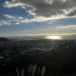
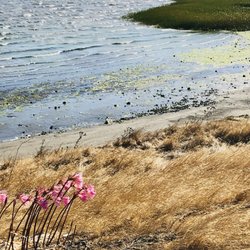
    ** The following review reflects my experience DURING the COVID-19 pandemic. **…read more It's actually not that hard to imagine the motorcycle hill climb races that took place here nearly a century ago. The surprise is how this steep escarpment remained untouched by real estate developers given how suburban this part of El Cerrito feels. I keep picturing that scene in "The Great Escape" where Steve McQueen jumped the POW camp fence as a testosterone-driven act of Nazi defiance. He would've ended up on somebody's backyard deck or in a hopefully filled swimming pool if he tried it now. You can get there from the bottom of the hill on the sorta corner of Navallier and Blake where you see a little staircase and a flyer posted on the fence about the hill's history. Or alternatively, you can take the hidden hillside stairs of El Cerrito and enter at the top through the nondescript path from Potrero Avenue. From the entrance, the first segment affords you a wide foot trail and a panoramic view of the bay (photo: https://bit.ly/2PI6CXp). The hillside trail itself is rustic in either direction with a lot of tall grass and dead trees that look like they were cut and left there for years. And yet, the constant views of El Cerrito make it a more pleasurable experience than you would expect despite the unexpected appearance of immobile wild turkeys (photo: https://bit.ly/3kO4wAM). RELATED - Up for a hike? Here's a collection of trails I've walked and reviewed: https://bit.ly/2OrC8nU

    A hiking trail that's perfect for both uphill and downhill hiking, Motorcycle Hill just proves…read moretrails can not only exist just about anywhere there is public land but it also proves that trails can be created at anytime thanks to the fortitude and creative energy of a group of community nature lovers. In this case Motorcycle Hill was founded by El Cerrito Trail Trekkers, which was formed in order to build, maintain, publicize and use the little known urban trails of El Cerrito, California and they not only lead local trail hikes for community members to participate in and explore but their main goal is to create new safe trails in safe open spaces so all can enjoy and make sure that paths continue to be cleared of excess brush so the fire danger remains low, which in this day and time is remarkable we've been so lucky in our hillside neighborhood. I've have been to Motorcycle Hill about six times and every time I venture downhill (notice not uphill because I'm no fool as I still have to walk all the way home!) and I get to experience something interesting and new every time I venture along Potrero Avenue high in the hills of El Cerrito to begin my trek each and every time. If you're not careful you will miss the start of the trail from the top of the hill each and every times as it literally is a slim dirt pathway in between two single-level homes. Once you keep walking along the dirt path and see a huge swath of small cactuses growing like bushes to your left, you know you are on the right path. From there you keeping walking straight along a dirt path which I believe was created much longer than the rest of the trail as it hugs the hillside until you hit what is basically a naturally-made observation area that looks over the entire cities of El Cerrito and Richmond and you would see it all if it weren't for the numerous eucalyptus trees blocking your view line. From there you will notice a nice wooden handrail that serves as your starting point and barrier for where you are supposed to walk next, down Motorcycle Hill. which is a series of small switchback dirt trails down the steep incline (hence the name Motorcycle Hill and dirt bikes tend to do this as they head downhill as well). And I do mean steep as you can tell this remains a fairly new trail that hasn't been traveling along by a vast number of trekkers as there remains a long of brush and dirt which can get in the way for a smooth trip down the hill. And just be careful because it can be a trip down this hill, as many a time I found myself slipping to the point where I had to grab on to a tree or even the dirt below to make sure I wasn't rolling down the steep hill. And beware of your shoes as they're going to get really dirty as even on a warm day after walking back and forth down the incline, my shoes were filthy of dry brown dirt. But that's just one of the sacrifices one makes when walking down one of El Cerrito's newest trails. Once you're done you'll find yourself among a number of eucalyptus trees that has been cut down to their stumps on the back side of some residences and then you'll once again find yourself in between a narrow pathway in between two homes, this time on Blake Street. Then you're back in the suburban community from where you once came with passing cars whizzing by. But for a little while, you will be as grateful as I was for this tiny and tranquil oasis among all of the chaotic suburban city life. At Motorcycle Hill, one can enjoy a healthy hike with scenic views of San Francisco Bay and beyond, and we have the El Cerrito Trail Trekkers to thank for all of this.

    Photos
    Motorcycle Hill - Motorcycle Hill

    Motorcycle Hill

    Motorcycle Hill - Motorcycle Hill

    Motorcycle Hill

    Motorcycle Hill - Motorcycle Hill

    See all

    Motorcycle Hill

    Rifle Range Road Trail - hiking - Updated May 2026

    Loading...
    Loading...
    Loading...