Pinole Creek Trail Photos


You might also consider
More like Pinole Creek Trail
Recommended Reviews - Pinole Creek Trail
Start your review...

Reviews With Photos

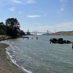
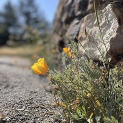
Since the first recorded flood in 1862, Pinole Creek had periodically flood downtown Pinole. In 1965, the Army Corps of Engineers responded by installing a flood control project on the creek. Their handy work can be seen on each side of San Pablo Ave. This 10 mile creek runs all year and is free flowing after it goes under San Pablo Ave.; the trail is a delightful place to walk. The first section is just a few blocks. The second section is about 1/2 mile and goes from San Pablo Ave to the bay where it connects with the Bay Trail. Both sections are flat and easy to walk. The vegetation is vastly different, the upper portion is tree lined, and the lower section is more barren, but it is more popular. It passes the park, and goes under the historic wooden railroad trestle that trains still rumble over. I see joggers, old folks, young people, dog walkers, and people with baby strollers. There is even a person on horseback who rides here. Steelhead and rainbow trout swim upstream, and I did see an egret catch a fish that just might have been a trout. There are also little birds, ducks, grebes, coots, and abandon cats. The trail ends at the railroad tracks at the bay. After passing under the railroad bridge the creek then empties into the bay.

Pinole Creek Trail is about half a mile long from the mouth of the creek that starts from the bay and into the downtown area of Pinole. The creek itself is 10.95 miles long running through town, but the trail is a nice, flat and paved area that many locals utilize to jog, run, walk and stroll. There are several bridges that runs through the creek, including an elevated wooden railroad bridge that is quite picturesque. On the other side of the trail is the Bay Trail, and parts of that trail is not paved, especially from San Pablo Ave. all the way to the mouth of the creek. However, both trails connect to Bayfront Park towards the railroads and Pinole Shores. So depending on what route to take, you can spend quite some time to get your exercise. For us, it's the exercise, walking the dog and being outside. Especially when the weather is nice, it's quite a nice stroll with enjoyable views while being out in nature and still in an urban setting. However, it's the best of both worlds and the city of Pinole does a great job of maintaining the trail. Along the creek is also Fernandez Park, with kids' playground, community center, basketball court and a baseball field. It gets busy during the weekend with plenty of outdoor activities for both adults and kids alike. The creek is a mixture of both salt and fresh water that attracts countless of wildlife. I think there's always a family of ducks that are always swimming or just hanging around the banks of the creek. There's definitely fish in the creek since you'll spot their activities on the water. And the many types of birds that will stop to take a bath or feed during their migration. At the mouth of the creek where it meets the bay, there's a waste water treatment plant, and depending on where the wind blows, you might get a whiff of an unpleasant smell. However, it's quite a nice area to explore during low tide as you can walk a pretty good distance off shore. Make sure your wearing the right kind of footwear since it's very muddy. Doing this activity makes me feel like a kid again. Here's a little secret: On both sides of the trail, there are rows of bushes that grow wild berries. People forage these bushes all the time and we've done our fair share of foraging. I've even made several milkshakes as a result of our foraging. I'm not gonna tell you which are the sweet ones, I'll let you figure that out yourselves. Oh, and the bushes are very thorny so be careful. Don't say I didn't warn you. read more


6 years ago
Hubbers and I don't live too far from here, and since our 6-month-old pup has now been trained to take walks, there was no better idea than to come and finally check this place out. We lucked out and came through on a nice clear late afternoon. The trail is available for walkers (for both 2 and 4 legged creatures) as well as bikers. People were conscious at social distancing (given the current pandemic crisis we're currently going through) which I thought was really cool. We really enjoyed it. We even lost track of how far we went because we got distracted looking out the water. The only thing I would suggest for improvement is maybe to have more trash bins. Don't get me wrong - the trail is generally nice, but it would be better if I wasn't seeing a bit of garbage here and there. (Yeah, there are some undisciplined people out there, shame on them.) Hubbers, our pup and I liked it so much we made a return visit in less than 48 hours. Definitely a good go-to to catch some fresh air and getting some steps in! read more


2 years ago
Since the first recorded flood in 1862, Pinole Creek had periodically flood downtown Pinole. In 1965, the Army Corps of Engineers responded by installing a flood control project on the creek. Their handy work can be seen on each side of San Pablo Ave. This 10 mile creek runs all year and is free flowing after it goes under San Pablo Ave.; the trail is a delightful place to walk. The first section is just a few blocks. The second section is about 1/2 mile and goes from San Pablo Ave to the bay where it connects with the Bay Trail. Both sections are flat and easy to walk. The vegetation is vastly different, the upper portion is tree lined, and the lower section is more barren, but it is more popular. It passes the park, and goes under the historic wooden railroad trestle that trains still rumble over. I see joggers, old folks, young people, dog walkers, and people with baby strollers. There is even a person on horseback who rides here. Steelhead and rainbow trout swim upstream, and I did see an egret catch a fish that just might have been a trout. There are also little birds, ducks, grebes, coots, and abandon cats. The trail ends at the railroad tracks at the bay. After passing under the railroad bridge the creek then empties into the bay. read more


8 years ago
Delightful little creek in the middle of quaint old town Pinole. Went for a walk here while visiting with a relative who lives nearby. We saw lots of mallard ducks and even a beautiful white egret. Bordering the creek are lush green rushes, and the path goes all the way out to Bayfront Park, which has a magnificent view of the bay. It's not a long walk, just about 15 minutes each way, and one side is paved for easy walking. We didn't see many people, mostly just a few locals going for strolls with their families. read more


9 years ago
10 years ago
More info about Pinole Creek Trail
San Pablo Ave & Pinole Valley Rd
Pinole, CA 94564
Directions
Hours
Outdoor Amenities
Ask the Community - Pinole Creek Trail
You might also consider


Pinole Creek Trail - hiking - Updated May 2026
Best of Pinole
People found Pinole Creek Trail by searching for…
Trending Searches in Pinole, CA
Botanical Gardens near Pinole Creek Trail
Bounce House Rentals near Pinole Creek Trail
Campgrounds near Pinole Creek Trail
Cherry Picking near Pinole Creek Trail
Cliff Jumping near Pinole Creek Trail
Dog Friendly Things To Do near Pinole Creek Trail
Flower Fields near Pinole Creek Trail
Flower Shop near Pinole Creek Trail
Garage Sales near Pinole Creek Trail
Garden Center near Pinole Creek Trail
Lakes & Ponds near Pinole Creek Trail
Nurseries & Gardening near Pinole Creek Trail
Outdoor Activities near Pinole Creek Trail
Outdoor Furniture Stores near Pinole Creek Trail
Party Equipment Rentals near Pinole Creek Trail
Pedicure near Pinole Creek Trail
Photo Spots near Pinole Creek Trail
Pick Your Own Farms near Pinole Creek Trail
Picnic Areas near Pinole Creek Trail
Places To Take Pictures near Pinole Creek Trail
Rock Quarry near Pinole Creek Trail
Running Trails near Pinole Creek Trail
Strawberry Picking near Pinole Creek Trail
Sunrise View near Pinole Creek Trail
Swimming Holes near Pinole Creek Trail
Table And Chair Rentals near Pinole Creek Trail
Browse Articles
Browse Nearby
BEST of Pinole, California Coffee near Pinole Creek Trail
BEST of Pinole, California Restaurants near Pinole Creek Trail
BEST of Pinole, California Things to Do near Pinole Creek Trail
BEST of Pinole, California Walking Trails near Pinole Creek Trail
BEST of Pinole, California Breakfast near Pinole Creek Trail
BEST of Pinole, California Parks near Pinole Creek Trail
BEST of Pinole, California Campgrounds near Pinole Creek Trail
Browse Brands
Related Searches in Pinole, CA
Affordable Kayak Rental Services in Pinole, California
Best Fishing Locations and Guides in Pinole, California
Best Nature Trails for Hiking in Pinole, California
Best Places for Horseback Riding in Pinole, California
Check Out Off Road Trails in Pinole, California
Discover Dog Friendly Trails to Explore in Pinole, California
Discover Kid Friendly Hiking Trails in Pinole, California
Discover Scenic Hiking Trails in Pinole, California
Discover Scenic Mountain Bike Trails Near Pinole, California
Discover Scenic Waterfall Spots in Pinole, California
Discover Top Nature Parks to Visit in Pinole, California
Discover Walking Parks in Pinole, California Near You
Discover a Hiking Trail in Pinole, California
Discover the Best Night Hike Trails in Pinole, California
Dog-Friendly Hikes With Dogs in Pinole, California
Enjoy Camping Adventures Around Pinole, California
Enjoy Exciting Mountain Biking Adventures in Pinole, California
Enjoy Kayaking Adventures in Pinole, California
Enjoy Tent Camping Spots Around Pinole, California
Enjoy a Beautiful Waterfall Hike in Pinole, California
Enjoy a Peaceful Nature Walk in Pinole, California
Enjoy the Best Picnic Spots and Ideas in Pinole, California
Enjoy the Best Walking Path in Pinole, California
Enjoy the Best Walking Trails in Pinole, California
Explore Beautiful Parks and Green Spaces in Pinole, California
Explore Easy Hikes Perfect for All in Pinole, California
Explore Fun Activities to Do in Pinole, California
Explore Popular Campgrounds Near Pinole, California
Explore the Best Beach Spots in Pinole, California
Explore the Best Swimming Holes Around Pinole, California
Explore the Best Trail Options in Pinole, California
Family Friendly Hiking With Kids in Pinole, California
Find Beautiful Views in Pinole, California
Find the Best Parks for Picnics in Pinole, California
Find the Best Scenic View Locations in Pinole, California
Great Places to Walk in Pinole, California
Hiking Trails With Waterfalls in Pinole, California
Off Leash Dog Hiking Trails in Pinole, California
Plan a Scenic Drive Route Near Pinole, California
Popular Outdoor Activities to Try in Pinole, California
Popular Picnic Spots to Visit in Pinole, California
Safe River Swimming Areas in Pinole, California
Safe and Fun Parks for Kids in Pinole, California
Top Climbing Spots and Gyms in Pinole, California
Top Paddleboarding Activities in Pinole, California
Top Running Trails to Explore in Pinole, California
Top Swimming Lakes to Enjoy in Pinole, California
Top Swimming Spots and Pools in Pinole, California