Albany Hill Park Photos


You might also consider
More like Albany Hill Park
Recommended Reviews - Albany Hill Park
Start your review...

Reviews With Photos


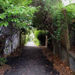
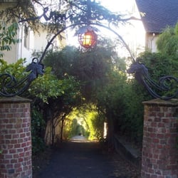
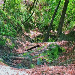
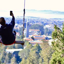
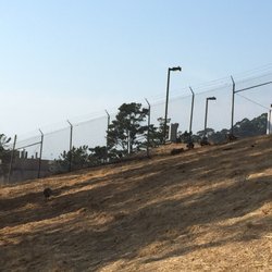
If you're in the mood to chase your partner around in a frisky manner, hoping to get some nature-nooky, this park is apparently a popular place to do it. At least if you're a butterfly. For the rest of us, it's not really ideal for that purpose--most of the park was either way too exposed or way too steep for playtime, unless you're really into that kind of thing. At the very top is a good spot for a picnic, however, and that was a nice find. With benches, a rope swing (see picture), and wildflowers. you could create a date right out of a Picasso painting. As a place to just take a little urban hike and enjoy the sun, the park is nice. Most of the access come from the 3 roads that wind up the hill and dead-end at different elevations, each with expensive, earthquake-taunting homes along the sides. As I climbed the hill from the base, I felt mocked for my efforts each time I crossed one--"All this work and I could have just DRIVEN up here!" Except for the very top, the trails are narrow, moderately steep, and not heavily maintained. As with most parks, alcohol and anything involving the word "fire" are prohibited. (ie. Campfires, fireworks, firearms, firewater...) The base of the hill on the north side abuts the residential neighborhood and boasts a small family- and picnic-friendly park, complete with a play structure (see pictures). It's right along the creek and the city has posted interpretive nature signs along the path describing the riverine ecosystem and the history of stream management in the area. TRIVIA: Dammit, I got scooped! Jessica M. stole my trivia about the city of El Cerrito being named for this hill.

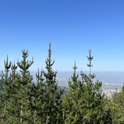
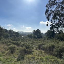
Albany Hill Park is aptly named, as it's just one big hill, or one big rock off of I-80!! You can drive to the top and follow the trails or stairs back down. Or you can start at the bottom and work your way to the top. On the way up one trail, I saw a cross and a swing, and plenty of dog walkers. There are some good views at the top looking through the trees. When I was here, I felt like I was at a super small version of Golden Gate Park. Albany is a really small city, just driving through you can pass through it and you might not know it, but when you see this big rock, you'll know you're definitely in Albany!! Very nice park, seems like the highlight of this little city to me!! read more


** The following review reflects my walking experience prior to the shelter-in-place order currently in effect. ** Ever notice that big rock off 880 as you pass Albany? It's covered in a thick of trees with what looks like condo buildings built into it. It doesn't look like it belongs there but probably due to some prehistoric volcanic activity, well, there you go. It made me don my guitar and sing out loud as I walked up Taft Avenue... "I am a rock I am an island... I've built walls A fortress deep and mighty That none may penetrate I have no need of friendship, friendship causes pain It's laughter and it's loving I disdain I am a rock I am an island..." OK, I don't know how to sing much less know how to strum, but hey, weren't Simon & Garfunkel great? This park? Not quite though it's getting there because there was a lot of construction and cement pouring going on when I made it to the summit. It's a small space with one walkway and a sloping hill, primarily for dog walkers. Like Mount Davidson across the bay, there's a cross, not as imposing but I'm guessing Christmas lights make their way around it during the holidays. Oddly there was no clear view of the bay despite its prominent position unless presumably you walk down to 99 Ranch Market. But I can't because I am a rock. I am an island. RELATED: Lost in Albany? Here's a collection of places I've visited and reviewed: https://bit.ly/3ebRKbk read more


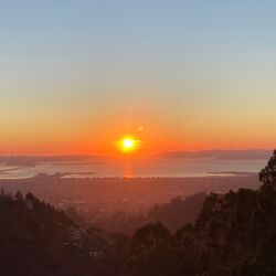
Nice hike. Not very challenging, but if you want a quick walk this is perfect. Really nice views at sunset and benches towards the top of the hill. Lots of monarch butterflies, they were beautiful! For those who are wondering, the swing is no longer there. read more


If you're in the mood to chase your partner around in a frisky manner, hoping to get some nature-nooky, this park is apparently a popular place to do it. At least if you're a butterfly. For the rest of us, it's not really ideal for that purpose--most of the park was either way too exposed or way too steep for playtime, unless you're really into that kind of thing. At the very top is a good spot for a picnic, however, and that was a nice find. With benches, a rope swing (see picture), and wildflowers. you could create a date right out of a Picasso painting. As a place to just take a little urban hike and enjoy the sun, the park is nice. Most of the access come from the 3 roads that wind up the hill and dead-end at different elevations, each with expensive, earthquake-taunting homes along the sides. As I climbed the hill from the base, I felt mocked for my efforts each time I crossed one--"All this work and I could have just DRIVEN up here!" Except for the very top, the trails are narrow, moderately steep, and not heavily maintained. As with most parks, alcohol and anything involving the word "fire" are prohibited. (ie. Campfires, fireworks, firearms, firewater...) The base of the hill on the north side abuts the residential neighborhood and boasts a small family- and picnic-friendly park, complete with a play structure (see pictures). It's right along the creek and the city has posted interpretive nature signs along the path describing the riverine ecosystem and the history of stream management in the area. TRIVIA: Dammit, I got scooped! Jessica M. stole my trivia about the city of El Cerrito being named for this hill. read more


It's not the greatest park in the world: it's small and not exceptionally beautiful. But, it's still nice to have. There are some good trails to climb that give you a good workout (especially if you are pushing an all-terrain stroller, which I wouldn't recommend, haha). There are some pretty nice views of the bay and the Oakland hills from up top, it goes up higher than you would think. I'm sure it's good for dog owners who live nearby, but as the new sign says: Please pick up your dog's poop! read more

16 years ago
18 years ago
7 years ago
18 years ago
18 years ago
15 years ago
12 years ago
15 years ago
13 years ago
12 years ago
12 years ago
More info about Albany Hill Park
700 Taft Ave
Albany, CA 94706
Directions
Hours
Outdoor Amenities
Ask the Community - Albany Hill Park
Review Highlights - Albany Hill Park
You might also consider


Why does Yelp recommend reviews?
Albany Hill Park - hiking - Updated May 2026
Best of Albany
People found Albany Hill Park by searching for…
Trending Searches in Albany, CA
Baseball Fields near Albany Hill Park
Botanical Gardens near Albany Hill Park
Bounce House Rentals near Albany Hill Park
Campgrounds near Albany Hill Park
Cheap Plants near Albany Hill Park
Cherry Picking near Albany Hill Park
Cliff Jumping near Albany Hill Park
Dog Friendly Things To Do near Albany Hill Park
Flower Fields near Albany Hill Park
Flower Shop near Albany Hill Park
Garage Sales near Albany Hill Park
Garden Center near Albany Hill Park
Lakes & Ponds near Albany Hill Park
Nurseries & Gardening near Albany Hill Park
Off Leash Dog Parks near Albany Hill Park
Outdoor Activities near Albany Hill Park
Outdoor Basketball Courts near Albany Hill Park
Outdoor Furniture Stores near Albany Hill Park
Parks For Parties near Albany Hill Park
Party Equipment Rentals near Albany Hill Park
Pedicure near Albany Hill Park
Photo Spots near Albany Hill Park
Picnic Areas near Albany Hill Park
Places To Take Pictures near Albany Hill Park
Places To Take Pictures For Prom near Albany Hill Park
Public Beaches near Albany Hill Park
Public Running Track near Albany Hill Park
Rock Quarry near Albany Hill Park
Running Trails near Albany Hill Park
Rv Rental near Albany Hill Park
Spray Tanning near Albany Hill Park
Sunrise View near Albany Hill Park
Swimming Holes near Albany Hill Park
Table And Chair Rentals near Albany Hill Park
Tennis Courts near Albany Hill Park
Browse Nearby
BEST of Albany, California Coffee near Albany Hill Park
BEST of Albany, California Restaurants near Albany Hill Park
BEST of Albany, California Things to Do near Albany Hill Park
BEST of Albany, California Walking Trails near Albany Hill Park
BEST of Albany, California Breakfast near Albany Hill Park
BEST of Albany, California Parks near Albany Hill Park
BEST of Albany, California Campgrounds near Albany Hill Park
Browse Brands
Related Searches in Albany, CA
Affordable Kayak Rental Services in Albany, California
Best Fishing Locations and Guides in Albany, California
Best Nature Trails for Hiking in Albany, California
Best Off Leash Dog Parks in Albany, California
Best Parks for Parties and Events in Albany, California
Best Places for Horseback Riding in Albany, California
Best Water Parks for Kids in Albany, California
Check Out Great Playgrounds in Albany, California
Check Out Off Road Trails in Albany, California
Discover Baseball Fields Around Albany, California
Discover Beautiful Garden Spots in Albany, California
Discover Dog Friendly Trails to Explore in Albany, California
Discover Fun Toddler Parks in Albany, California for Your Little One
Discover Kid Friendly Hiking Trails in Albany, California
Discover Lakes & Ponds to Explore in Albany, California
Discover Popular Photo Spots in Albany, California
Discover Public Beaches to Visit in Albany, California
Discover Scenic Hiking Trails in Albany, California
Discover Scenic Mountain Bike Trails Near Albany, California
Discover Scenic Waterfall Spots in Albany, California
Discover Soccer Fields in Albany, California Near You
Discover Top Nature Parks to Visit in Albany, California
Discover Top State Parks to Visit in Albany, California
Discover Walking Parks in Albany, California Near You
Discover a Hiking Trail in Albany, California
Discover the Best Beaches in Albany, California
Discover the Best Kids Park Spots in Albany, California
Discover the Best Night Hike Trails in Albany, California
Discover the Best Running Track in Albany, California
Dog-Friendly Hikes With Dogs in Albany, California
Enjoy Camping Adventures Around Albany, California
Enjoy Kayaking Adventures in Albany, California
Enjoy Tent Camping Spots Around Albany, California
Enjoy a Beautiful Waterfall Hike in Albany, California
Enjoy a Peaceful Nature Walk in Albany, California
Enjoy the Best Picnic Spots and Ideas in Albany, California
Enjoy the Best Walking Path in Albany, California
Enjoy the Best Walking Trails in Albany, California
Explore Beautiful Botanical Gardens in Albany, California
Explore Beautiful Parks and Green Spaces in Albany, California
Explore Easy Hikes Perfect for All in Albany, California
Explore Family-Friendly Zoos and Wildlife in Albany, California
Explore Free Picnic Areas Around Albany, California
Explore Fun Activities to Do in Albany, California
Explore Parks With Pull Up Bars in Albany, California
Explore Popular Campgrounds Near Albany, California
Explore Popular Picnic Areas Around Albany, California
Explore Popular RV Parks Around Albany, California
Explore Popular Recreation Centers Around Albany, California
Browse Articles
People who viewed Albany Hill Park also viewed
Cragmont Park
15 reviews
Berkeley Hills
Hillside Natural Area
16 reviews
Nicholl Knob
10 reviews
The Big C
76 reviews
UC Area
Bayfront Park
20 reviews
Cerrito Vista Park
13 reviews
Strawberry Creek Park
27 reviews
West Berkeley
Garber Park
12 reviews
Oakland Hills
Grotto Rock Park
6 reviews
Berkeley Hills
Pinole Creek Trail
9 reviews