Potomac Wayside Park Hiking Photos


You might also consider
More like Potomac Wayside Park
Recommended Reviews - Potomac Wayside Park
Start your review...

2 years ago
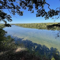
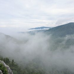
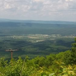
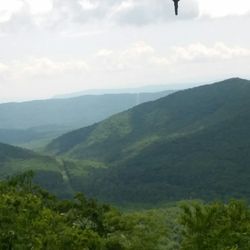
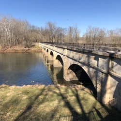
We decided to start our hike to Weverton Cliffs, here at the Potomac Wayside Park. We drove right past it the first time. Then, coming back toward the Exxon station from MD, we saw the "merge" lane into the "Park". I mean there were tons of no parking signs until at the end where you could fit 3 cars. I was second car. I was confused as I didn't see any park. But the Appalachian Trail went over 340 bridge so we just suited up and headed across the bridge. The walk across the bridge was a lot longer than it looked. When we came back to the car after our journey We saw the sign for Potomac Wayside Park. Didn't help much. There's still nothing to see, until I googled the location to add to Yelp. Google says there's a trail to take you to a waterfall but honestly, we saw that trail when we parked and immediately thought, that's someplace where homeless would burrow and druggies and the like, so I was surprised to read that the trail was actually part of the "Park." Park address is Purcellville VA but the sign on the gravel road said it was part of the Harper's Ferry NPS. Check it out. Take some pictures. Then I might come back. I come to Harper's Ferry every couple years and if legit, I'll give it a try. read more


More info about Potomac Wayside Park
210400 Jefferson Pike
Purcellville, VA 20132
Directions
Hours
Outdoor Amenities


Potomac Wayside Park - hiking - Updated May 2026
Best of Purcellville
People found Potomac Wayside Park by searching for…
Hiking Trails With Waterfalls in Purcellville, Virginia
Parks in Purcellville, Virginia
Waterfalls and Swimming Holes in Purcellville, Virginia
Places to Take Pictures in Purcellville, Virginia
Things to Do in Purcellville, Virginia
Beautiful Views in Purcellville, Virginia
Waterfalls in Purcellville, Virginia
Easy Hiking Trails in Purcellville, Virginia
Walking Trails in Purcellville, Virginia
Running Trails in Purcellville, Virginia
Off Road Trails in Purcellville, Virginia
Scenic View in Purcellville, Virginia
Cliff Diving in Purcellville, Virginia
Creeks in Purcellville, Virginia
Running Tracks Open to the Public in Purcellville, Virginia
Trail in Purcellville, Virginia
Bridge in Purcellville, Virginia
What to Do in Purcellville, Virginia
Hiking Groups in Purcellville, Virginia
Off Leash Dog Hikes in Purcellville, Virginia
Running Routes in Purcellville, Virginia
Kids Birthday Party Venues in Purcellville, Virginia
Trending Searches in Purcellville, VA
Botanical Gardens near Potomac Wayside Park
Bounce House Rentals near Potomac Wayside Park
Campgrounds near Potomac Wayside Park
Garden Center near Potomac Wayside Park
Hair near Potomac Wayside Park
Mexican Catering near Potomac Wayside Park
Nurseries & Gardening near Potomac Wayside Park
Outdoor Activities near Potomac Wayside Park
Outdoor Furniture Stores near Potomac Wayside Park
Parks near Potomac Wayside Park
Party Equipment Rentals near Potomac Wayside Park
Pedicure near Potomac Wayside Park
Pick Your Own Farms near Potomac Wayside Park
Picnic Areas near Potomac Wayside Park
Places To Take Pictures near Potomac Wayside Park
Browse Articles
Browse Nearby
BEST of Purcellville, Virginia Restaurants near Potomac Wayside Park
BEST of Purcellville, Virginia Coffee near Potomac Wayside Park
BEST of Purcellville, Virginia Things to Do near Potomac Wayside Park
BEST of Purcellville, Virginia Breakfast near Potomac Wayside Park
BEST of Purcellville, Virginia Beaches near Potomac Wayside Park
BEST of Purcellville, Virginia Horseback Riding near Potomac Wayside Park
BEST of Purcellville, Virginia Campgrounds near Potomac Wayside Park
BEST of Purcellville, Virginia Hotels near Potomac Wayside Park
Browse Brands
Related Searches in Purcellville, VA
Affordable Kayak Rental Services in Purcellville, Virginia
Best Fishing Locations and Guides in Purcellville, Virginia
Best Fun Things to Do in Purcellville, Virginia
Best Places for Horseback Riding in Purcellville, Virginia
Discover Dog Friendly Trails to Explore in Purcellville, Virginia
Discover Popular Bike Trails in Purcellville, Virginia
Discover Top Boat Tours in Purcellville, Virginia for All Ages
Discover a Hiking Trail in Purcellville, Virginia
Discover the Best Night Hike Trails in Purcellville, Virginia
Dog-Friendly Hikes With Dogs in Purcellville, Virginia
Enjoy Kayaking Adventures in Purcellville, Virginia
Enjoy River Tubing Adventures in Purcellville, Virginia
Enjoy Tent Camping Spots Around Purcellville, Virginia
Enjoy the Best Tubing Experiences in Purcellville, Virginia
Enjoy the Best Walking Trails in Purcellville, Virginia
Experience Stunning Sunset Views in Purcellville, Virginia
Explore Beautiful Botanical Gardens in Purcellville, Virginia
Explore Beautiful Parks and Green Spaces in Purcellville, Virginia
Explore Bike Rentals Throughout Purcellville, Virginia
Explore Easy Hikes Perfect for All in Purcellville, Virginia
Explore Family-Friendly Zoos and Wildlife in Purcellville, Virginia
Explore Popular Campgrounds Near Purcellville, Virginia
Explore Popular RV Parks Around Purcellville, Virginia
Explore Scenic Lakes to Visit in Purcellville, Virginia
Explore Top Dog Parks in Purcellville, Virginia Near You
Explore the Best Boating Spots in Purcellville, Virginia
Family Friendly Hiking With Kids in Purcellville, Virginia
Find Fun Things to Do With Kids in Purcellville, Virginia
Find Popular Ziplining Spots Around Purcellville, Virginia
Find Top Skate Parks in Purcellville, Virginia for All Skill Levels
Find the Best Playgrounds to Visit in Purcellville, Virginia
Find the Best Scenic View Locations in Purcellville, Virginia
Find the Best Swimming Pools in Purcellville, Virginia Today
Fun Toddler Activities to Try in Purcellville, Virginia
Hiking Trails With Waterfalls in Purcellville, Virginia
Off Leash Dog Hiking Trails in Purcellville, Virginia
Plan a Scenic Drive Route Near Purcellville, Virginia
Popular Fishing Spots to Explore in Purcellville, Virginia
Popular Kids Activities in Purcellville, Virginia
Popular Outdoor Activities to Try in Purcellville, Virginia
Popular Places to Take Pictures in Purcellville, Virginia
Popular Things to Do in Purcellville, Virginia
Relax at Natural Hot Springs Near Purcellville, Virginia
Safe River Swimming Areas in Purcellville, Virginia
Safe and Fun Parks for Kids in Purcellville, Virginia
Top Climbing Spots and Gyms in Purcellville, Virginia
Top Paddleboarding Activities in Purcellville, Virginia
Top Swimming Lakes to Enjoy in Purcellville, Virginia
People who viewed Potomac Wayside Park also viewed
Hollow Brook Trail
12 reviews
Sweet Run State Park
4 reviews
Piscataway Crossing Regional Park
5 reviews
W & OD Trail - Purcelville Access
4 reviews
Weverton Cliff Trail
8 reviews
Washington & Old Dominion Trail
60 reviews
Third Winchester Battlefield Trails
6 reviews
C&O Canal
12 reviews
Blackburn Trail Center
1 review
Buzzard Hill
1 review