Request a quote

Response quality
Excellent
Response time
5 hours
Services - Virtual 360 Media
Film editing
Film production and preparation
Motion graphics creation
4 More Services
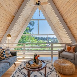
Virtual 360 Media Photos


You might also consider
More like Virtual 360 Media
Recommended Reviews - Virtual 360 Media


More info about Virtual 360 Media
Ask the Community - Virtual 360 Media
You might also consider


Why does Yelp recommend reviews?
Virtual 360 Media - estatephotography - Updated May 2026
Browse Nearby
BEST of Portland, Oregon Coffee near Virtual 360 Media
BEST of Portland, Oregon Things to Do near Virtual 360 Media
BEST of Portland, Oregon Restaurants near Virtual 360 Media
BEST of Portland, Oregon Drones near Virtual 360 Media
BEST of Portland, Oregon Florists near Virtual 360 Media
BEST of Portland, Oregon Custom Cakes near Virtual 360 Media
Browse Brands
Related Cost Guides
Related Searches in Portland, OR
Affordable Photographers You Can Trust in Portland, Oregon
Affordable Wedding Photographer Services in Portland, Oregon
Best Architectural Photography in Portland, Oregon
Best Interior Photography Studios in Portland, Oregon
Best Photography Stores & Services in Portland, Oregon
Book Drone Photography Services in Portland, Oregon
Book Expert Session Photography in Portland, Oregon
Book Your Senior Portraits Session in Portland, Oregon
Book a Professional Photography Studio in Portland, Oregon
Compare Photo Booth Rentals in Portland, Oregon
Connect With a Reliable Real Estate Broker in Portland, Oregon
Creative Landscape Photography Services in Portland, Oregon
Creative Portrait Photography in Portland, Oregon
Discover Top Photography Services in Portland, Oregon
Experience Professional Boudoir Photography in Portland, Oregon
Expert Home Staging Services in Portland, Oregon
Expert Property Management Solutions in Portland, Oregon
Explore Commercial Real Estate Opportunities in Portland, Oregon
Explore Expert Aerial Photography in Portland, Oregon
Explore Maternity Photography Options in Portland, Oregon
Explore Photography Classes Available in Portland, Oregon
Explore Top Newborn Photography Services in Portland, Oregon
Find Top Real Estate Options in Portland, Oregon
Find Top Videographers in Portland, Oregon for Your Events
Find Top-Rated Drones Available in Portland, Oregon
Find a Baby Photographer Near You in Portland, Oregon
Find a Top Engagement Photographer in Portland, Oregon
Hire a Family Photographer in Portland, Oregon
Hire a Freelance Photographer in Portland, Oregon Now
Hire a Skilled Commercial Photographer in Portland, Oregon
Locate Real Estate Offices Throughout Portland, Oregon
Popular Places to Take Pictures in Portland, Oregon
Professional Corporate Headshots in Portland, Oregon
Professional Drone Videography in Portland, Oregon
Professional Graduation Photography in Portland, Oregon
Professional Land Surveying in Portland, Oregon
Professional Pet Photography Services in Portland, Oregon
Professional Product Photography in Portland, Oregon
Professional Real Estate Agents in Portland, Oregon
Quality Event Photography Services in Portland, Oregon
Reliable Drone Services Offered in Portland, Oregon
Skilled Headshot Photographer in Portland, Oregon
Top Wedding Photographer Options in Portland, Oregon
Top-Rated Professional Headshots Available in Portland, Oregon
Top-Rated Title Company Options in Portland, Oregon
Trusted Portrait Studio Located in Portland, Oregon
Trusted Real Estate Services Available in Portland, Oregon
Trusted Rental Agencies Serving Portland, Oregon
Service Offerings Nearby
People found Virtual 360 Media by searching for…
Arts & Entertainment in Portland, OR
Land Surveying in Portland, OR
Places to Take Pictures in Portland, OR
VHS to DVD Transfer in Portland, OR
Loft Apartments in Portland, OR
Vacation Rentals in Portland, OR
Film Production Companies in Portland, OR
Realty Companies in Portland, OR
Psychic Mediums in Portland, OR
Property Management in Portland, OR
Translation Services in Portland, OR
Temporary Housing in Portland, OR
Drone Photography in Portland, OR
Trending Searches in Portland, OR
Auto Detailing near Virtual 360 Media
Cd Rates near Virtual 360 Media
Cheapest Gas near Virtual 360 Media
Commercial Truck Repair near Virtual 360 Media
Contractors near Virtual 360 Media
Dumpster Rental near Virtual 360 Media
Ethanol Free Gas near Virtual 360 Media
Gas Prices near Virtual 360 Media
Irrigation near Virtual 360 Media
Lawn Sprinkler Repair near Virtual 360 Media
Mulch Delivery near Virtual 360 Media
Phone Repair near Virtual 360 Media
Same Day Alterations near Virtual 360 Media
Browse Articles
People who viewed Virtual 360 Media also viewed
Kenneth Benjamin Reed
47 reviews
Eliot, North Portland
Artem’s Art
3 reviews
Southwest Portland
DigaPix
16 reviews
Craig Doby Digital Media Production
3 reviews
HH Photography
2 reviews
Southwest Portland
Hayes Peterson Photography
9 reviews
StereoEye Productions
5 reviews
Cully, Northeast Portland
Video Media
6 reviews
Old Town - Chinatown
Rico Media Productions
2 reviews
Kerns, Northeast Portland
Oculus Photo
1 review
Southwest Portland