Request a quote
You can now request a quote from this business directly from Yelp
Services - TopoLogic
Real estate
TopoLogic Photos


You might also consider
Recommended Reviews - TopoLogic
Start your review...

2 years ago
More info about TopoLogic
Ask the Community - TopoLogic
You might also consider


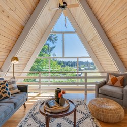


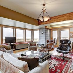
TopoLogic - estatephotography - Updated July 2026
Browse Nearby
Browse Brands
Related Cost Guides
Related Searches in Portland, OR
Accurate Soil Testing Near Portland, Oregon
Affordable Photographers You Can Trust in Portland, Oregon
Affordable Wedding Photographer Services in Portland, Oregon
Best Architectural Photography in Portland, Oregon
Best Interior Photography Studios in Portland, Oregon
Best Photography Stores & Services in Portland, Oregon
Best Real Estate Companies Serving Portland, Oregon
Book Drone Photography Services in Portland, Oregon
Book Expert Session Photography in Portland, Oregon
Book Your Senior Portraits Session in Portland, Oregon
Book a Professional Photography Studio in Portland, Oregon
Browse No Credit Check Houses for Rent in Portland, Oregon
Certified Notaries Available in Portland, Oregon
Certified Real Estate Appraiser in Portland, Oregon
Certified Residential Structural Engineer in Portland, Oregon
Compare Photo Booth Rentals in Portland, Oregon
Connect With Leading Home Developers in Portland, Oregon
Connect With Private Landlords in Portland, Oregon
Connect With a Reliable Real Estate Broker in Portland, Oregon
Creative Landscape Photography Services in Portland, Oregon
Creative Portrait Photography in Portland, Oregon
Discover Apartments for Rent in Portland, Oregon
Discover Top Photography Services in Portland, Oregon
Efficient Residential Property Management in Portland, Oregon
Experience Professional Boudoir Photography in Portland, Oregon
Experienced Architects Near Portland, Oregon
Experienced Commercial Real Estate Agent in Portland, Oregon
Experienced Rental Agents Available in Portland, Oregon
Experienced Structural Engineers Near Portland, Oregon
Expert Drafting Services Near Portland, Oregon
Expert Home Staging Services in Portland, Oregon
Expert Property Management Solutions in Portland, Oregon
Explore Available Condominiums in Portland, Oregon
Explore Commercial Real Estate Opportunities in Portland, Oregon
Explore Expert Aerial Photography in Portland, Oregon
Explore Expert Interior Design in Portland, Oregon
Explore Maternity Photography Options in Portland, Oregon
Explore Photography Classes Available in Portland, Oregon
Explore Top Newborn Photography Services in Portland, Oregon
Find Leasing Agents Near You in Portland, Oregon
Find Skilled Engineers Near Portland, Oregon
Find Top Landscape Architects in Portland, Oregon
Find Top Real Estate Options in Portland, Oregon
Find Top Real Estate School Options in Portland, Oregon
Find Top Videographers in Portland, Oregon for Your Events
Find Top-Rated Drones Available in Portland, Oregon
Find a Baby Photographer Near You in Portland, Oregon
Find a Top Engagement Photographer in Portland, Oregon
Service Offerings Nearby
People found TopoLogic by searching for…
Property Management in Portland, Oregon
Photographers in Portland, Oregon
Apartments in Portland, Oregon
Realty Companies in Portland, Oregon
Property Surveyor in Portland, Oregon
Drone Photography in Portland, Oregon
Commercial Real Estate in Portland, Oregon
Relocation Services in Portland, Oregon
Things to Do in Portland, Oregon
Real Estate Developers in Portland, Oregon
Escrow Services in Portland, Oregon
Apartments for Rent in Portland, Oregon
Roof Inspectors in Portland, Oregon
Hoa Management in Portland, Oregon
Permit Expediter in Portland, Oregon
Glamour Shots in Portland, Oregon
Videographers in Portland, Oregon
Title Company in Portland, Oregon
Trending Searches in Portland, OR
Browse Articles
People who viewed TopoLogic also viewed
1LS Surveying
7 reviews
Miller Land Surveying
4 reviews
Framework Engineering
11 reviews
Industrial District, Central Eastside, Buckman, Southeast Portland
Ferguson Land Surveying
1 review
Mill Park
MOR Photo
6 reviews
TS Media
7 reviews
PNW Gate and Fence
6 reviews
Kenton, North Portland
Weddle Surveying
4 reviews
Southwest Portland
Eleete Real Estate
14 reviews
Southwest Portland
Virtual 360 Media
2 reviews
Alphabet District, Northwest