Sturtevant Falls Photos


You might also consider
More like Sturtevant Falls
Recommended Reviews - Sturtevant Falls
Start your review...

Reviews With Photos

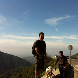
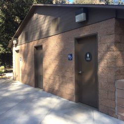
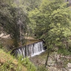
Sturtevant Fall is a 50 foot waterfall drop in the San Gabriel National Monument park within Arcadia. Accessible by hiking the Chantry Flat trailhead from the parking lot. The trail is 3.3 miles long. This trail is extremely busy on the weekend. Best to visit this trail on weekdays early in the morning at 6:00am when the parking lot opens. On the weekends the parking lot is full by 6:10am so best to get there when gate opens. If you want a peaceful hike best on weekdays. The falls are worth a visit as beautiful. Plus a small pool forms beneath which is great to dunk in on hot days. Note the water is super cool but refreshing. Bring water shoes as rocky bottom. And don't forget you have a long climb back to the parking lot. If you seek a longer hike you can do 7.3 mile loop. During this loop you will cross several rivers, cabins and more. The hike is partially shaded. Even on the weekends, most of this hike is quiet and empty of people. As mentioned, there is a parking lot. There is a bathroom next to the lot. Plus a mini cafe where you can get your adventure pass, five dollars. Pass needed for the parking lot.

It was my first time hiking, so my cousin decided to take me to a place he's hiked before: Sturtevant Falls. The scenery was so beautiful! I've never seen so many hills and waterfalls before in my life. It might be a normal view for people who live in California, but for a person who lives in Louisiana and has never hiked before everything was so new to me. The incline wasn't too bad, but be aware of logs and rocks you have to step on as I had fallen a bit into the water due to small slips. Parking wasn't too bad, but it was pretty crowded on a Saturday morning so we had to wait for a minute to get parking. Overall, it was a new experience for me but a fun one. I'd go hiking again, but what a better way to start my first hiking experience than at Sturtevant Falls!

This is a nice hike! The drive up the mountain is very curvy so take it slow. The parking is rough! We arrived at 10a on a Friday and it took us 30 mins to find a spot. The hike itself is moderate and very similar to Eaton canyon. You'll cross various water streams and will a few water falls before the big one, plus, cute cabins. Overall, very enjoyabe with nice views

Late morning hike with @KonaWildBlue Picked up daily parking pass at Party House Liquor and made our way to the trailhead. AM cloud disappeared and the sun started beaming down, luckily this trail is shaded for the most part. Few stream crossing, several wood cabins, natural mini slide into rock pool , and made it in and out to the falls. Doggo had a blast of an adventure and spent a good 10 min attempting to get the log out of the waterbed
")
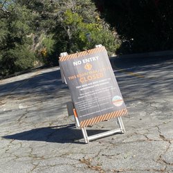
** THIS TRAIL HAS BEEN REOPENED ** If you're looking for a moderate hike with a flowing waterfall during any season, this it the hike for you! 1. Arrive the earlier the better due to limited parking. I'd say there is parking for about 30 cars or so. 2. You must get an "Adventure Pass" for day parking. You can either buy one before going up the mountain at "Party house Liquor (1002 N Santa Anita Ave)" which is open as early as 7am or you can buy one on site at the Chantry Flats but not sure what their hours of operation are if you plan on buying it the same day. Other reviewers also so you can buy one ahead of time at REI or Big 5. One Day Pass is $5 or Annual Pass for $35. 3. They do have an additional private parking lot that costs $20 to park or you can park further outside along the mountain pass for free, but definitely a much longer walk/hike. 4. The best parking for the trail is the first parking strip right next to the bathrooms. The trail starts right where the bathroom is. The upper level parking lots are for the picnic areas. 5. They do have a store there that sells snacks, drinks AND beer! 6. Most hikes normally start with an incline but this one actually starts with a decline instead. Keep in mind that there are multiple inclines and you will end the hike going back with an incline before reaching the parking lot. 7. You do have to cross the river a couple of times, but most of them have a built wooden plank or is easy enough for children and dogs to cross. 8. There are quite a number of private cabins a long this trail. There were a couple of families who were hanging out with loud music and bbqing. Not sure how to inquire on cabin rentals but did not see any paths for vehicles, so I'd assume you would have to hike in and out to access the cabins. 9. Even when its freezing cold and foggy in the city, it was sunny and blue skies up in the mountain and the hike was rewarding at the end. Pretty spacious area to hang out, and plenty of rocks to sit on. Overall, would recommend for waterfall seekers.

Amazing hike all around less than four miles, the first part all down hill along a stream of water hiking to a waterfall. The path is wide and fun for dogs to jump in and out of water constantly to cool down. We got an annual parking pass for 30 dollars at Big 5 but the two lots fill up by 8 am every single weekend so you have to arrive at the crack of dawn. The hike back to the car is uphill for the last fifteen minutes but when you're done it feels fantastic. It's so shady for most of the walk as well. Sadly it's getting more and more packed with people as the other trails seem closed now all the time.

Got our Adventure Pass at Big 5 and went there around 7:30 am on a Thursday so the parking lot was pretty empty, just be careful of the windy road driving up. The hike itself is pretty easy, fun to cross the little wooden planks across streams and be surrounded by trees as opposed to the dusty and bare trails in the valley. Good amount of shade and the falls were so nice to sit next to, water was cold and refreshing, and the hike back up was a little tiring but not the worst. A very good workout and then grab food in 626, I would come back again.


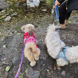
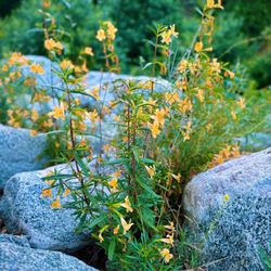
A Hidden Gem in the Mountains! Sturtevant Falls is one of my favorite trails in the San Gabriel Mountains. The 3.3-mile (1.5 - 2hrs hike) round-trip is the perfect blend of challenge and relaxation, just enough of a workout to feel accomplished but still super enjoyable. The scenery along the way is stunning, with shaded paths, creek crossings, and charming little cabins that make you feel like you're stepping into another world. The waterfall at the end is such a rewarding sight, especially in the spring when it's flowing strong. I always recommend getting there early, especially on weekends, since parking at Chantry Flats fills up fast. Don't forget your Adventure Pass! The uphill trek back can be a bit of a workout, but nothing too intense. Just wear good shoes and bring water. It's also dog-friendly (just keep them leashed). If you're looking for a peaceful nature escape not far from LA, this hike is a must. I'll definitely be coming back again and again!


6 years ago
The hike was overall pretty short (~3.7 miles) and fairly flat. The parking and final quarter mile of the drive to the trailhead was a bit difficult because it was crowded and the parking was incredibly hard to find. The road becomes a one way and parallel parking may be required if you come late. Remember to bring comfortable shoes and water as the day gets hotter. Also brings masks as the weekends are a bit packed. read more


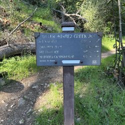
A fun hike that's super convenient for people living in the 626 area. Come early in the morning or you'll find it hard to get parking. The parking lots are full pretty quick, so you most likely have to park in the cliff areas next to the road. There's helpful signs whenever there's a branched road to make sure you're on course to Sturtevant Falls, although you can take alternative trails and fo to Hermit Falls too. It starts off very hilly and then becomes mildly hilly. The last stretch walking back is the most difficult because it is the most uphill and that's when you're the most tired. But a 1.8 mile hike isn't too bad. We saw a lot of elderly and children along the trail too. Lots of people bring their dogs with them on the hike, but you'd have to keep a leash on them otherwise it's a $150 fine. There was also a lot of bikers to watch out on the trail. No wild animals but we did hear about people who saw bears and salamanders on the trail. We saw plenty of people being walking sticks with them which definitely helps on the hike. The scenery was great, although we came around end of September and most of the trees and foliage appeared to be dried out. Lots of shade makes it an enjoyable hike, and everyone is super nice. Every hiker we walked by said good morning to us. read more


We went on a Sunday around 11:30am and had to wait 15 minutes before finding parking. Overall it was a great hike! I haven't hiked for quite awhile and it was relatively easy. There were lots of shades on the way to the waterfall so even in 80 degrees it was not that hot. Make sure you buy an adventure pass for $5 at the pack stop to avoid tickets! read more


Before parking, purchase a parking pass which you can do at the local gas station or at the park itself- pass cost is $5. Take advantage of public restrooms near parking lot although there are a few portable restrooms on route- various trails- we hiked to the falls- some steep areas- can be a bit rocky in places-gorgeous views- take a walking stick to make it easier on yourself- it's roughly a 4 mile round trip hike to falls and back. Worth the effort. read more


Our group of friends came out here on a Saturday morning for a scenic hike. The drive up the winding mountains of Sierra Madre was a bit intense to get to the hiking area. Parking is very difficult and the lot is full by 8am. Don't forget to purchase an Adventure pass at Big 5 Sporting Goods before heading out here. You can also purchase one at the convenience store on site. Sturtevant Falls is great for beginners. There are a total of 8 different trails so you have plenty of options based on your fitness level. The hike was 1.8 miles one way and took about 2 hours to complete. For first timers:: ***Arrive early for ideal parking otherwise you'll have to find a spot along the mountains. ***Wear sunscreen or a hat as there are some areas that are not tree-lined. ***Be sure to have comfortable and/or waterproof hiking shoes since you will be crossing some streams. Some trekking poles are helpful but not necessary. ***Pack enough water and some protein bars just in case you need extra energy. ***The trail is pet friendly and pets must be on a leash. We really enjoyed this hiking trail in SGV. The greenery and the man made waterfall made the hike so peaceful and relaxing. Most of the hike was shady but there are areas that have no trees. My favorite part was the "natural" waterfall at the end of the hike. Beautiful and serene. Perfect spot to get those photos! read more


7 years ago
I loved this hike so much that I went back the next weekend! It has the perfect balance of shade and sun, as well as a mix of challenging inclines and easy pavements. The sound of the waterfall and creek was super soothing, and the cabins along the way were cute additions. Also, there were so many cute puppies! I would NOT recommend using their bathrooms along the way. It looked like someone exploded in every single stall and there were remnants of Twinkie boxes, Doritos, and zebra cakes. Bring lots of water and don't forget the $5 cash for your day pass. We couldn't find a gas station prior to driving uphill, so I just purchased it there. Both times, I got lucky with a parking spot at the top. Most people parked 1-3 miles down and had to walk it. Last advice: if you have children under the age of 7, I recommend not going on the second hike to the secondary waterfall. I forgot the name but you have to go right instead of down the slope. The terrain is more rugged and the paths are not paved. The paths are also very small in certain areas and the inclines are steep! Also, the finals views and "waterfall" were not worth it. People tagged this one up! read more


6 years ago
This was an awesome hike! I am bit out of shape so, the last 10 minutes back up to the parking lot "killer" .....but I survived!!! So will you.! Definitely worth it! read more

Beautiful waterfall in the SQV, quick easy drive from the city, amazing views. We drove up Santa Anita and parked in the Chantry Flats parking lot. $5 for the day pass and $35 for the yearly pass. We bought the day pass from the store above the upper parking lot. They also sell water and drinks. The trail was paved for about half of the way, and then well maintained for the 2nd half going to the falls. The stream was flowing with water which is very nice during this time of year. The weather wasn't too hot, and the trail was mostly shaded, so it was pretty easy and comfortable to hike. The trail is 3.8 miles round trip from the Chantry flats parking lot. The water fall is very pretty, the photos definitely don't do it justice. It does kind of dry up in the summer time. Great place to visit! Highly recommend! read more


4 years ago
This is definitely one of those scenic hikes you should do to see the beautiful majestic waterfall at the end! It's especially beautiful after this seasons rains with plenty of green vegetation all along the trails. Protips: Come EARLY to this trail, preferably before 9am because parking literally sucks so bad here! You highly likely will have to street park along the mountain road and hike your way up to the trailhead. YES they do ticket you if you don't have an Adventure pass parking permit! Get those before coming up to the trail at your local REI, Big 5, some Walmarts for $5! The trail overall is a very easy hike going down with minimal slopes. Round trip it's a 3.1mi hike to the falls if you take the direct trail. There are about 3 tiny water crossings so you may get your shoes wet. The waterfall itself is does get abit crowded with everyone taking photos and just hanging out. But if you wait you'll get your chance for a photo op too! Be warned though the walk back especially on the last leg going up the very steep hill can be strenuous for the elderly, little kids, or those that are just out of shape... no names here. haha There's only 2 porta potties on the entire trail, one at the beginning at the trailhead and the second at the bottom of the concretely sidewalk in the first leg of the hike right after the bridge. Overall it's a fun scenic hike for your family and friends and 4 legged friends. Yes there are alot of dogs walking on this trail but it's pretty easy. But just save up enough energy to get back up the hill on the last leg! Stay fit my friends! read more

Beautiful waterfall at the end of hike if it rains. Otherwise, it's pretty a sad looking trickle (okay, that's understating it a little).. This trail is short but pretty. It's more of a place to enjoy nature instead of finding exercise... oh, except for the gigantic ass asphalt road in the beginning/end that you have to walk up and down to get to the waterfall. It's an insane 5 min workout. My very nonathletic friend died on the way back up. The drive up is unnerving. Narrow roads on a super curvy mountain. Adventures pass - $5 read more

Come early or you'll have to park down the hill. You'll need the adventure pass to hike this trail, you can purchase one at the little store at the end of the road. Trails starts downhill and ends uphill, prepare yourself. We are in a drought so I didn't see any falls but I imagined it and it was beautiful LOL. read more


7 years ago
Solid hike that's easy and doable for the whole family, even for those couch potatoes! The drive up can be a bit curvy so caution for those who easily get carsick. There are plenty of parking spaces in the lower and upper levels and also a gravel lot if you keep driving on the dirt path from the upper level lot. $5 parking that you can buy at any local Walmart, Big 5, etc. However, when I went recently, it seemed like a lot of people just gambled and risked it since they don't patrol the lot often. So park at your own risk or pay $5 for peace of mind. The entire hike is 3.6 miles or so. Do to the drought that CA has been having lately, the waterfall itself is a trickle into a puddle. Not much of a pool of water for you to play in but still beautiful and a great photo oppt. Great hiking trail for all ages. The only time I broke a sweat was the last 1-0.5 mile uphill back to the parking lot but other than that, it was pretty much a stroll in the park. Dog friendly but need leash. read more


Day off work, it had just pour the day/week before why not go for a hike! Don't forget your parking permit! Never have I ever seen this much water at this hike. As your walking down that paved road something is different. It's not dead quiet anymore you can hear the stream! There are mini waterfalls as your going down. There was a huge rock slide, but it is easy to get around. Once you get further down you use to have that option of going left or go right to take the green bridge. Not anymore you gotta take the bridge since there is so much water running! It's nice to walk along the stream as it use to be dried up. Getting across those little (not so little anymore ) water streams got a tougher. Definitely look at your options, A. Hop on rocks and pray you don't slip and fall, B. Walk right through the water and get your feet soaked, C. Head back. There was a couple ahead of me that took option B and walked right through the water. I was determined to not get my feet wet. Look for ways to cross before and after the typical way of getting across the streams. I was able to do it without getting wet. One of them I did have to balance on a fallen tree branch. The waterfall at the end is HUGE compare to what it was before. It's just gushing out water which was amazing. Took a few pictures and headed back. Hopefully the water doesn't dry out by the time you guys are reading this. If it does, I uploaded some pictures for you guys! read more


7 years ago
We hiked last week and the water level was excellent! My toddler absolutely enjoyed the falls. There is shade right next to the falls to relax and enjoy and the sturtevant falls trail is itself shady with tons of trees ,bugs and mosquitoes. Tips: 1. We spotted a dead rattlesnake and it's good to be cautious. 2. Last 0.6 MI of the hike is uphill and requires lot of strength to carry babies. 3. Adventure pass is required to park in the lot. 4. Parking is crazy and it's good to show up early or in the afternoon. read more


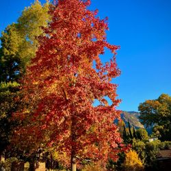
This is probably the best hike you can do in SoCal. SoCal isn't really known for its hikes or outdoor activities. Everyone here seems to be going 100mph, so it's nice to find a hike on the outskirts of the valley and get away from the busy, busy lifestyle that is Southern California. Located in Arcadia, this hike is just a 40 minute drive from DTLA (which isn't far at all). Once you drive the winding roads, you forget you're even in a metropolitan area. You don't hear the traffic and you can barely see the smog, so it's great! You're really in the outdoors here. Parking can be a hassle and you do have to buy a parking permit ($5), but they use that money to good use. While you're hiking, you can see people working hard on the trail, especially if there was rain and/or a mudslide. The hike itself isn't bad. It's about a mile and a half, and you start by going downhill. Once you get to the bottom, the terrain is relatively flat with very minimal elevation gain. There are abundant trees that provide shade and the trail is wide. Multiple people and groups can be on the trail at the same time, and there's usually no problem with cross traffic. The hike is also right along the river. You might have to cross it a couple of times depending on the flow of the stream, so I would just be prepared to get your shoes a little wet (not soaked though). The trail is actually really cool. There are a bunch of little (abandoned?) houses along the path, and they're all unique. The end of the hike is a tiny little waterfall. I recommend going here a day or two after a rainstorm! The falls look a lot better! I'm not entirely sure what it looks like during the hot, summer months though. And I definitely recommend going here during the fall when the leaves are changing colors. You'll think you're in a completely different place! Overall, this is a great hike! It's not that far and it's not that hard at all! read more


7 years ago
If you're in LA, this is a great place for a weekend morning hike. We went to just see Sturtevant Fall with a slight detour. There was quite a bit of rain prior months so the falls and creeks were full on running. If you take a detour like we did, I recommend bringing waterproof hiking shoes. So much fun though! PARKING IS TERRIBLE. The small lot next to the trailhead fills very quickly so if you can, get there as early as possible. If not, most late comers park along the road up to the trailhead. Grab the first spot you see! read more


7 years ago
Really enjoyed this hike! ~4 miles from the parking at Chantry Flats to the waterfall, and back. Not a hard hike at all, it does cross water twice towards the end. The last bit is all uphill right before you get back to the parking lot. It was perfect weather and with the rain we've been getting over the last two weeks the waterfall was flowing pretty well. The autumn color also was a huge plus. I saw quite a few people even thought it was a Friday. I can imagine it's very crowded on the weekends. Parking wasn't hard for me but, again, weekends are probably monstrous. Bathrooms are available in multiple places. Overall, I really enjoyed this hike. Loved the trees, water, and lack of graffiti/trash. Would go again. read more


6 years ago
Wow. The entire hike is gorgeous, there are water streams around every corner and the scenery is breathtaking. We got to the end of the hike which I believe is about 1.4 miles, and got into the water, it's FREEZING but so worth it. The way back is a bit harder towards the end because it's steep, but so worth it none the less. There's no parking enforced even in the parking lot due to covid. So you can park without the 20$ fee. read more


10 years ago
I wanted to meet up with a friend for lunch at Din Tai Fung in Arcadia and he suggested this hike for the morning to work up an appetite. I arrived at 6:20 AM on the Saturday before fathers day and the parking lots were full and the cars had already started parking down the road. People aren't kidding when they say the parking is crazy. The road is a really narrow mountain road and there are very few spots to park alongside the road and a lot of cars were sticking out in the road. You have to go up to the parking lot to turn around and come back down and park. I ended up parking a 15 minute walk down the road. I bought my $5 daily adventure pass the day before so luckily I didn't have to walk back and forth to the parking lot to buy one. You need an adventure pass for the parking lot as well as anywhere along the road. The road dead ends in the parking lot so you don't have to worry about missing it. Once all the parking was settled everything else was great. We went on an 8.6 mile hike. We started by going to the falls and there were only two other people there at 7:30 in the morning. Then we walked back and took the Gabrielino trail and did the Mt. Zion loop returning via the lower winter creek trail. We finished the hike a little after 11AM. The majority of the trail was shaded and cool. The only part that was in the sun was coming down the backside of Mt Zion, then we were back under the trees for the rest of the trail. The sun was intense the short time we were in it. I was glad that we started so early. I was surprised how green everything was for the middle of June in drought ridden CA. The creek was low but there was still a good amount of water in it. The low water levels made the multiple creek crossings easy. There was a large amount of bugs that were annoying, buzzing in our ears. I would wear bug spray next time, but they didn't bite so it was just a minor annoyance. The views were beautiful. My favorite spots were at the top of the falls, and the top of Mt. Zion. Mt Zion was less than a 1/4 mile off the main trail and while the view was blocked some by the vegetation, I was glad we got to see it. Some of my favorite aspects of the hike included the pretty green bridge at the beginning of the hike, the falls, and walking alongside the creek. I would definitely do this hike again. It is different than most hikes in CA, being next to water and greener than normal. My hamstrings, knees and ankles were pretty sore after hiking 8.5 miles. There was an even mixture of uphill and downhill. If you only do the waterfall hike its pretty flat and only around 2 miles. Next time I'll bring my dog. There were a lot of boy scouts, people with dogs and families hiking the trail. I would go at 6AM when they open if not a little before. Its cooler and you have a better chance of good parking. The parking lots tend to be fuller on the weekend because of all the overnight campers. read more


Decided to hike this trail with some friends on a hot Saturday afternoon. The trail itself was not difficult to find and it was well demarcated throughout with some interesting vegetation. Roundtrip ~3 miles. The elevation gain is minimal, which is perfect for beginner/casual hikers. The route was also mostly shaded as well, which was a relief from the sun, and a good portion of it was paved. The trail leads to a nice waterfall (which during the summer was impressive that there was still any water)! There were people lounging by the rocks, in the water, picnicking at the end by the waterfall, which created a nice atmosphere. All in all, a good casual hike, not challenging. Be sure to buy a day permit ($5) from the little store near the trail head to avoid getting a fine! Bring cash, as with card you will pay an extra processing fee. read more

#@!% too much damn hiking. Note to self: get a map. Note to you: get a map. It's all nice and that, and one wrong turn and it was 7 miles total. I lost my smile, and it was gone for days. It's beautiful and serene, that is, after you park -- it can be frustrating. Free outside the park and a little jaunt, $5-10 for a parking pass within the Chantry Flats parking area. It fills up fast. If it does, you'll be forced to park outside and for free. If so, it'll buy you lunch with the savings. It's an intermediate trail. At times, a "youngen" or beginner will do just fine. It's not complex or dangerous, but it is length -- an elder person would have trouble. The trail has it all: narrow trails with trees along a stream, little bridges, little makeshift crossings with a downed tree, small cabins (to own or rent, who knows), and the highlight -- a waterfall area (this put the Falls in the Sturtevant!). Most "normal" people walk to this point, have lunch, and return. Me? Au contraire. Overall, very worthy. Good place to go with a date, or with a small group. read more


6 years ago
Easy hike with some amazing views. At the end of the hike is a beautiful waterfall, which is definitely the highlight of this trail. Would recommend to get there before noon, because it's get harder to find a parking spot later in the day read more


I started my day at 7 a.m. I hiked this a week ago, and was a bit frustrated finding an adventure pass. I drove up to the closest 7/11 that claimed to have a pass (they don't sell them anymore). I drove to REI, they weren't open. I drove to the cabin up ahead of the trail, and they weren't open either. Luckily, the cabin up ahead of the trail allows you to park there, as long as you write your license plate number on the provided envelopes and put $5. Don't be rude and pay for parking if you DON'T have an adventure pass! Paying helps provide feed for the neighboring farm animals. Sturtevant Falls was a fairly easy hike. This hike is a walk in the park with a lovely view; perfect for talking and walking. The falls still runs and isn't dried out, which is great. Downfall is the parking, fills up VERY quickly. Even on a weekday, there are a lot of people and a lot of kids running wild. For those who are looking for something more strenuous, this hike isn't for you. It took me an hour to hike this. I decided to do Hermit Falls as well to make it a real, long work out. Hermit Falls and Sturtevant took me approx. 3 hours total. First time hikers, this is one for you. read more


15 years ago
A beautiful short inverted hike that ends at a waterfall! (http://www.yelp.com/biz_photos/kJPZ29VCEAvyadf-N5QJkw?select=PUM8k6onST5VVfwymDLy9w) I came with some friends today to see the waterfall, and it was nice to get away from the usual LA scene. Who knew such a place existed so close to the city? Unlike most hikes, you reach your destination by going downhill. Thus, you won't have to worry about reaching your destination because the decline is pretty easy. The real question is, can you make it home?! Oh, but of course. You do have to hike uphill to get out, but it's really not bad! Round trip, this hike is a little over 3 miles, but it's not very challenging. Much of the trail is in the shade, and it even gets a little chilly by the waterfall. You do have to cross 3 streams, though, so be careful because it might be a little slippery. That is, unless you don't mind dipping your feet into the water! Buy an adventure/parking pass for $5, and make sure you get there early to find a good parking spot. It's likely that there won't be space up at the very top of the mountain, so park somewhere along the road! read more

Parking: 5 dollars get you in again. There is no way you can park in the residential and walk up unless you are willing to make the long trek to the trailhead. Buy your parking permit ahead of time at REI or any other sporting goods store. Encourage ya'll to go early, parking fills up in their parking lot, but there is also parking places along the mountain. The hike.... is a 3 mile out and back reverse hike. It will be easy going to the falls because you are going downhill. It has plenty of shade. It's different sorry going back up because there is steep inclination and the sun will be beating on you depending on the time you go back. As you hike to the falls, you see a lot of cabins. These cabins are protected by the gov. I think some people live in their by the sight of smoke from the chimney pipe. Very cool! Eventually, the hike ends at a beautiful waterful. Good place to take a break and have a picnic also. Good workout for the glutes and legs! You'll have model legs in no time at all. Cheers and beers everyone! read more


11 years ago
An easy-medium hike. The only downside is the parking which is $5 weekdays or $10 weekends, and only in the dirt parking lot (the tiny one up with the "convenience store") The nicer parking lots before this are fair game if you have your yearly permit or gotten a day pass from REI but that's just a pain to go get. I believe the 'convenience store' has a day pass but they are opened on weekends only. That means you must plan ahead and/or have cash with you at all times if you want to come here last minute. Follow the instructions on payment when the store is closed and you have no permit. It seems you can park outside on the sides free, but I am not the kind to risk a dumb ticket for $5. Your call. The walk down to the beginning of the trail is boring and steep. After that everything changes to a mellow, beautifully shaded hike with an unfortunate measly stream of water, thank you drought. But it is guaranteed that your lungs will thank you for the detoxifying experience. I would come back, bring a lunch and a book. read more


5 years ago
This is a great leisurely hike that's mostly shaded. Low impact, high reward with a great waterfall at the end. There were lots of people on the trail.. kids, and pups. There is a small community alongside the hiking trail. We stopped a gentleman bringing goods to his cabin and he explained to us that there are 81 small cabins along the trail that cost about $40-50K (land lease). Most owners do not live there full time but use the cabins as a weekend or vacation home. The homes have electricity and some homes have outhouses so I'm not so sure how many of them have full running water. Some cabins were burning wood in their fireplaces. It kind of felt like we were walking through a movie set. It's fascinating that folks would buy these cabins and have the motivation to walk all of their supplies to their cabins every time. The waterfall was flowing and some folks walked into the water to cool off their feet. I'd highly recommend this hike. It's easy and gorgeous. Our pup loved it! read more


4 years ago
One of the falls accessible from the chantry flats parking area! So glad this pristine and clean fall was in the same area as hermit falls because I was pretty depressed after seeing how graffiti tagged hermit falls is now (so sad people can't respect nature) Perfect hike for a sunny day since majority is shaded except the steep and exposed paved road at the end to get back to the parking lot! The hike is also pretty flat except again for that last paved road NOTE: Parking on the weekend is crowded and difficult, we ended up asking people who were walking back for their car if they wanted a ride back in exchange for their spot! Don't forget your adventure pass for Parking read more

13 years ago
It is a very moderate 1.8 mile hike (one way) to the waterfall. Lot's of shade, easy trail, and in general, quite pleasant. There are a number of campgrounds that you pass by, and I counted at least 8 (!!!) potty patties on the way. With all those structures the hike seemed a little crowded, but maybe it's just me. In spring, the waterfall is at its best (don't expect the Niagara, though). Take a light lunch to enjoy by the water. Even though the hike is very doable even for beginners, be mindful of the hill you have to climb up on the way back (since you go down first) and leave some energy for it. In the best traditions of the urban hike, that hill is even paved for you : ) We saw a rattle snake on it, by the way, so watch your step. Overall, the hike shouldn't take you more than 2 hours at a very comfortable pace. Oh, parking. Make sure you get a $5.00 pass at the station. They do ticket. Once you are done and leaving, be good sports and give your pass away to somebody who has just arrived - your kindness will return to you! read more


If you expect to see a raging waterfall you will be disappointed. With the hot weather and lack of rain the waterfall is just a little trickle. The actual hike to the waterfall was very nice and easy. Plenty of tree coverage so there is plenty of shade and doesn't get too hot. There are some bugs, not as much as some people were saying but some bug spray won't be a bad idea. A few steps to make your trip a little easier. Step 1: buy an adventure parking pass at big 5 before you go there. It saves time Step 2: get there very early if you plan on going on the weekend. We had to park down the road and hike to the hike. Step 3: save your energy, the last part of the hike is up a windy road and is sunny the majority of the time. Definitely the toughest part of the hike. If you are bringing kids, make sure you have a carrier. We brought our 3 month old and two year old. Even though they had a blast we got a workout carrying them up the windy road at then end, while they were fast asleep. Overall it was a great hike, good vibes, good weather, and not too challenging. We will be going back again. read more


3 years ago
Awesome hiking trail that will leave you feeling like you got a good workout and not totally deflated and useless for the rest of the day. Our guidebook said it was a 4.3 mile round trip hike that should have taken around 2.5 hours with an elevation gain of 650 feet. In total, our hiking app had us at about 6 miles and 2 hours when all was said and done, including the walk to and from the car to the trailhead. Parking was no joke, so get here as early as possible. Also, get your adventure pass ahead of time so you're not wasting time getting one at the little store with everyone else. The hike itself is picturesque and loaded with water features, if you're into that sort of stuff. Had no idea there were so many cabins peppered throughout the trail. Kind of cool. The trail is very well shaded with trees, so you won't be in direct sunlight the whole time, thank goodness. Make sure you've conserved enough energy for the last 0.6 miles of the winding, paved fire road because it's a doozy. Once you've conquered that last part, you'll feel like a champ and will want to treat yourself to a well deserved pint of ale. read more


11 years ago
A pretty easy hike with a small waterfall at the end of the trial. The only semi-difficult part was climbing back up in the last 10 minutes on the paved road because there was a bit of an incline. Other than that, I saw many children and older folks hiking this trial. SUPER pet friendly. I saw at least 20+ dogs during the whole hike. But honestly folks, pick up your dog's business after. When you're using google map, put in "Chantry Flat" and it should get you there. There's a parking lot but it's not very big. It will get filled up pretty quickly. $5 for all day parking. But don't get discouraged! There are free street parkings along the road. You might have to walk a bit though. They also have a small restaurant for food, ice cream, drinks, etc. There are bathrooms at the entrance and another one near the bridge. Random thought/question.. how come the folks I see in this trial don't really like saying hi?? Many other trails people are always so pleasant. Strange... read more


2 years ago
More info about Sturtevant Falls
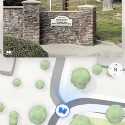
Arcadia, CA 91006
Directions
Hours
Indoor Amenities
Outdoor Amenities
Sturtevant Falls Reviews in Other Languages
Ask the Community - Sturtevant Falls
Is it open yet?
I believe so. We recently visited the area & I didn't see any closures on any sections of the mountains.
Hi is this place open now?
Came all the way from OC.. still closed. Bummer wish they'd update on here.
Anyone know when this will open again? My favorite hike in all of Southern California.
Closed
Went this morning, 11/23/2021 and the road is still closed, 5k fine for trespassing. I saw a truck go around tho?
Is trail to water fall still closed?
Yes it is still closed as of 1/3/2021 and for those of you who went without masks thanks for screwing that up for the rest of us! It's closed due to too many crowds and idiots not social distancing and/or not wearing masks as directed. The Ranger… Read more
Has the hike trail reopened?
Yes, I went 8/1, but they do close throughout the day when it gets full and te-open with in the same day once they have availability, I went in a Saturday at 2:40 pm, had to come back about 1 - 1/2 later to be able to get in.
How safe is the drive to the park? I am planning to visit next week with my special needs son. Is the drive to the park is easy on the road or we have to drive through cliffs go up the mountains. I am driving from Orange county. Thank you
The drive isn't so bad until the the last quarter mile to the parking lot, it definitely gets crowded and can get difficult to find a parking spot. May require parallel parking and gets narrow because it the road is a one way and cars are surrounded… Read more
Review Highlights - Sturtevant Falls
You might also consider


Why does Yelp recommend reviews?
41 reviews that are not currently recommended
The reviews below are not factored into the business's overall star rating.
5 years ago
5 years ago
11 months ago
12 years ago
13 years ago
2 years ago
10 years ago
11 years ago
2 years ago
7 years ago
9 years ago
8 years ago
9 years ago
9 years ago
8 years ago
10 years ago
12 years ago
5 days ago
Sturtevant Falls - hiking - Updated May 2026
Best of Arcadia
People found Sturtevant Falls by searching for…
Hiking Trails With Waterfalls in Arcadia, CA
Beautiful Views in Arcadia, CA
Places to Take Pictures in Arcadia, CA
Waterfalls and Swimming Holes in Arcadia, CA
Scenic Night View in Arcadia, CA
Beach Hiking Trails in Arcadia, CA
Hiking Trails Kid Friendly in Arcadia, CA
Nature Reserves in Arcadia, CA
Hiking With Kids in Arcadia, CA
Trending Searches in Arcadia, CA
Boat Rental near Sturtevant Falls
Botanical Gardens near Sturtevant Falls
Bounce House Rentals near Sturtevant Falls
Campgrounds near Sturtevant Falls
Cheap Plants near Sturtevant Falls
Cherry Picking near Sturtevant Falls
Cliff Jumping near Sturtevant Falls
Flower Fields near Sturtevant Falls
Flower Shop near Sturtevant Falls
Garage Sales near Sturtevant Falls
Garden Center near Sturtevant Falls
Lakes & Ponds near Sturtevant Falls
Nurseries & Gardening near Sturtevant Falls
Outdoor Activities near Sturtevant Falls
Outdoor Furniture Stores near Sturtevant Falls
Party Equipment Rentals near Sturtevant Falls
Pedicure near Sturtevant Falls
Photo Spots near Sturtevant Falls
Picnic Areas near Sturtevant Falls
Places To Take Pictures near Sturtevant Falls
Rock Quarry near Sturtevant Falls
Running Trails near Sturtevant Falls
Rv Rental near Sturtevant Falls
Scenic Drive near Sturtevant Falls
Sunrise View near Sturtevant Falls
Swimming Holes near Sturtevant Falls
Table And Chair Rentals near Sturtevant Falls
Browse Articles
Browse Nearby
BEST of Arcadia, California Coffee near Sturtevant Falls
BEST of Arcadia, California Things to Do near Sturtevant Falls
BEST of Arcadia, California Restaurants near Sturtevant Falls
BEST of Arcadia, California Parks near Sturtevant Falls
BEST of Arcadia, California Breakfast near Sturtevant Falls
BEST of Arcadia, California Campgrounds near Sturtevant Falls
BEST of Arcadia, California Thrift Stores near Sturtevant Falls
Browse Brands
Related Searches in Arcadia, CA
Affordable Kayak Rental Services in Arcadia, California
Best Fishing Locations and Guides in Arcadia, California
Best Nature Trails for Hiking in Arcadia, California
Best Places for Horseback Riding in Arcadia, California
Check Out Off Road Trails in Arcadia, California
Discover Dog Friendly Trails to Explore in Arcadia, California
Discover Kid Friendly Hiking Trails in Arcadia, California
Discover Scenic Hiking Trails in Arcadia, California
Discover Scenic Mountain Bike Trails Near Arcadia, California
Discover Scenic Walking Paths in Arcadia, California
Discover Scenic Waterfall Spots in Arcadia, California
Discover Walking Parks in Arcadia, California Near You
Discover a Hiking Trail in Arcadia, California
Discover the Best Night Hike Trails in Arcadia, California
Discover the Best Running Track in Arcadia, California
Discover the Breathtaking Waterfall Trail in Arcadia, California
Dog-Friendly Hikes With Dogs in Arcadia, California
Enjoy Camping Adventures Around Arcadia, California
Enjoy Exciting Mountain Biking Adventures in Arcadia, California
Enjoy Kayaking Adventures in Arcadia, California
Enjoy Tent Camping Spots Around Arcadia, California
Enjoy a Beautiful Waterfall Hike in Arcadia, California
Enjoy a Peaceful Nature Walk in Arcadia, California
Enjoy a Scenic Walk in Arcadia, California
Enjoy the Best Walking Trails in Arcadia, California
Exciting Cliff Jumping Spots in Arcadia, California
Explore Beautiful Parks and Green Spaces in Arcadia, California
Explore Easy Hikes Perfect for All in Arcadia, California
Explore Fun Activities to Do in Arcadia, California
Explore Popular Campgrounds Near Arcadia, California
Explore the Best Beach Spots in Arcadia, California
Explore the Best Trail Options in Arcadia, California
Family Friendly Hiking With Kids in Arcadia, California
Find Beautiful Views in Arcadia, California
Find the Best Parks for Picnics in Arcadia, California
Find the Best Scenic View Locations in Arcadia, California
Hiking Trails With Waterfalls in Arcadia, California
Off Leash Dog Hiking Trails in Arcadia, California
Plan a Scenic Drive Route Near Arcadia, California
Popular Outdoor Activities to Try in Arcadia, California
Popular Picnic Spots to Visit in Arcadia, California
Safe River Swimming Areas in Arcadia, California
Safe and Fun Parks for Kids in Arcadia, California
Top Climbing Spots and Gyms in Arcadia, California
Top Paddleboarding Activities in Arcadia, California
Top Running Trails to Explore in Arcadia, California
Top Swimming Lakes to Enjoy in Arcadia, California
Top Swimming Spots and Pools in Arcadia, California
People who viewed Sturtevant Falls also viewed
Hermit Falls
298 reviews
Santa Anita Canyon
84 reviews
Millard Canyon
141 reviews
Monrovia Canyon Park
329 reviews
Switzer Falls - USDA Forest Service
293 reviews
Gabrielino Trail
80 reviews
Azusa River Wilderness Park
27 reviews
Inspiration Point via Castle Canyon
191 reviews
Stoddard Canyon Falls
32 reviews
Chantry Flat Recreation Area
276 reviews