Spooner Lake Trailhead Photos


You might also consider
More like Spooner Lake Trailhead
Recommended Reviews - Spooner Lake Trailhead
Start your review...

Reviews With Photos - Spooner Lake Trailhead

It started out as just a little stroll through the woods to clear my head from some personal stuff that's happening in my life. I always walk/hike/run with gum so I put a few extra pieces in my pocket. Initially, I just wanted to walk the two mile loop around Spooner Lake, but it was SUCH a pretty fall day that I had to continue onto Marlette Lake trail from Spooner. I was feeling fine, not thirsty and not needing to use the restroom so I was good to go for as long as I could. After 5.5 miles one way, I saw the beautiful blue lake, took some pictures, and made it back to my car at about 11 miles total. The last 5 minutes I started to get a little parched and was happy there was a huge bottle of iced water in my car. What a stunning solo day out in the woods.

We wanted to go on a nice and easy Father's Day hike and that's exactly what we got at this Spooner Lake 2.1 mile loop trail. We had our very old dog with us and she can't do hilly hikes anymore so this fairly flat and pretty trail was perfect for us. Someone in another review complained about downed trees obstructing the path but everything has now been cut away and cleared. There were beautiful wild flowers in bloom! And you can "smell" spring and summer now as you walk along and encounter sweet-smelling yellow bitterbrush flowers and the butterscotch/vanilla scent of ponderosa pines. At one point, I smelled licorice and learned that it was likely coming from a flowering plant called Gray's licorice-root. There are a few benches along the path for resting while taking in the nice views. And if you fish, you can try to catch some trout! The trail can be a little dusty at times so wear appropriate shoes. Parking costs $10 for locals.

I've driven past this Trailhead / area almost every weekend in winter and most weekends in summer on my way to snowboard or lounge in Tahoe. I was looking for a casual hike and to satisfy my curiosities of the area. I arrived and found the toll booth vacant. I grabbed an envelope and tossed my cash inside - $10 per vehicle during the summer. I didn't have a pen or pencil so I left the envelope blank, tore off the receipt part and tossed that on my dashboard. I really wish they would keep pencils or something close by for those of us that forget to bring along a writing instrument! Warning - there were signs everywhere stating that the lake has leeches. I wasn't intending on going into the water but once I saw this sign, there was clearly NO chance of me touching the water. Once parked, I checked out the restroom facility. Quite nice. Flushing toilets, running water and very clean. I headed down to the lake. I think they had an event there recently because two large tents were still up. I decided to head to the left and saw that there were a few small pathways on all sides - basically small ones made by people trying to get closer or further from the lake itself. The first half was in and out of the shade but flat. I stopped at a few benches and vistas to snap some pictures and take a few deep breaths of fresh air. Once I hit the TRT junction, the trail got a little steeper. It was not challenging by any stretch, but was not the flat trail of earlier in the course. There were several beautiful Aspen groves that were breathtaking. I didn't see any large animals but there were plenty of chipmunks and birds along the way. After 2.1 miles in and out of the sun I was disappointed to see the end of the trail. I would have been happy to see more beautiful vistas. Instead, I headed back closer to the parking lot and pulled up a seat at a picnic bench to enjoy a snack.

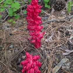
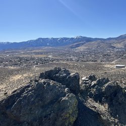
The Spooner Lake area, part of Lake Tahoe Nevada State Park, was a great starting place for a 9.5 mi hike to Marlette Lake and back. For Nevada residents, the entry fee per car is $8. There is ample parking and clean restrooms. The trails are well-marked: the loop around Spooner Lake, the hike to Marlette Lake via either the trail (no mountain bikes) or North Canyon Rd, which one shares with mountain bikes. The offshoot trails to the Tahoe Rim Trail and the trail east to Chimney Beach are also well-marked. One can rent Kona mountain bikes at the general store. The hike to Marlette Lake is uphill going north, but there are some nice benches constructed in pretty spaces so that breaks are well-justified and earned. Even with the drought, both Spooner and Marlette Lakes were beautiful and seemingly unaffected. Keep your eyes out for the coolest plant I've ever seen: the red snow plant (Sarcodes sanguinea). It is a bright red half wildflower, half mushroom looking thing. When they first emerge from the ground their "arms" are all wrapped around them and they feel like hard jelly if you touch them with a stick. When they mature their "arms" grow what look like "bells" or bell-shaped flowers. They are so cool and are all along the North Canyon Rd part of the trail.

This is an easy hike with easy-on-the-eyes views of the Spooner lake. Again, this is no where close to the ton of brilliant beaches and hikes in Tahoe area but given the easy length (2.5 miles) and minimal elevation (124 ft.), I'd recommend this as more of a family friendly hike or a hike primarily meant for break days if you're looking to catch a breath between some really tough hikes
")
Spooner Lake trailhead leads to the Tahoe Rim Trail (TRT) and has it's own 2.5 miles path around the perimeter of the lake. There's a geocoded Everytrail tour of spooner linked below. There's also an opportunity to head up to Marlette Lake. The trail to Marlette is perfect for those who want to do a strenous 10 or 11 mile day hike. Folks who didn't want to add the strenuous part could just meander around Spooner Lake. Here's the photo tour. http://www.everytrail.com/view_trip.php?trip_id=2171198&code=1fa6cc52e3212241aefb4b241deef6c3 I should mention that there's two entrances to these trails: you can do paid parking for $10 and this will get you access to Sand Harbor up the road as well. Sand Harbor is a great snorkeling spot and you can essentially snorkel around in a million year old glacial moraine. However, if you're just visiting Spooner and Lake Marlette try parking at the entrance shown on US 50 in the first couple of photos at the link above. It's only $1 to park there.


I love Spooner lake hike, it is easy and enjoyable. You walk around lake in and out of shade - so always enjoyable. It is fairly flat with a few up hills but nothing terrible. Even the most non sporty person can do this hike/walk. Just over 2 miles around. There are benches and a beach area for resting but don't go in water unlike Marlette you can swim in this one. Great little outing. With the parking closed on 50 you now must pay at the entrance cabin but I think it is worth the money

We went here and walked around the lake with our lovable lab. It was a beautiful area. The trail was flat but I suggest hiking boots this time of year as there was some icy snow in spots. The bathrooms were available at the trailhead and were well maintained. read more


We had an amazing hike around Spooner Lake back in June. It's an easy walk with just a few mosquitos around. Peaceful and filled with bird sounds, not many people when we were there on a weekday. Bring your binoculars to check out the many birds and woodland creatures around. Definitely wear good walking shoes and bring some water. This trail is a short drive from where the casinos are and well worth the time to get away from the people and hustle bustle that can sometimes be found in Lake Tahoe around state line. read more


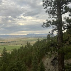
One of my favorite fall destinations. The aspen grove along the southern side of the lake feels like walking through an enchanted forest. We came up for a hike in mid-October on a weekday; arguably one of the best times to come to the Tahoe Basin. The fall colors are beautiful, the weather is very comfortable, and the number of visitors is greatly diminished. The Park Service is doing a huge upgrade to the picnic and parking area. The bathrooms are closed, but there are port-a-potties available. The improvements should make this portion of the park more ADA accessible. The paths down to the lake are well marked and the 2-mile loop trail is mostly flat with a few easy changes in elevation. The trail, however, is not ADA accessible. Lots of spots to see the mixed pine and aspen forest, numerous birds and waterfowl. The views across the lake are stunning and there are so many spots to take share-worthy pictures. The trail is a mix of shade and sunlight - layers are definitely recommended as is appropriate footwear. There are numerous benches and information plaques along the trail. Parking is free if you have an annual Nevada Parks Pass. The entrance gate was unmanned, so it is very much honor code for paying the entry fee. I highly recommend this trail AND I highly recommend getting a State Parks Pass. It pays for itself after only a few visits to the parks and trailheads throughout Nevada. read more


6 years ago
It started out as just a little stroll through the woods to clear my head from some personal stuff that's happening in my life. I always walk/hike/run with gum so I put a few extra pieces in my pocket. Initially, I just wanted to walk the two mile loop around Spooner Lake, but it was SUCH a pretty fall day that I had to continue onto Marlette Lake trail from Spooner. I was feeling fine, not thirsty and not needing to use the restroom so I was good to go for as long as I could. After 5.5 miles one way, I saw the beautiful blue lake, took some pictures, and made it back to my car at about 11 miles total. The last 5 minutes I started to get a little parched and was happy there was a huge bottle of iced water in my car. What a stunning solo day out in the woods. read more


4 years ago
We wanted to go on a nice and easy Father's Day hike and that's exactly what we got at this Spooner Lake 2.1 mile loop trail. We had our very old dog with us and she can't do hilly hikes anymore so this fairly flat and pretty trail was perfect for us. Someone in another review complained about downed trees obstructing the path but everything has now been cut away and cleared. There were beautiful wild flowers in bloom! And you can "smell" spring and summer now as you walk along and encounter sweet-smelling yellow bitterbrush flowers and the butterscotch/vanilla scent of ponderosa pines. At one point, I smelled licorice and learned that it was likely coming from a flowering plant called Gray's licorice-root. There are a few benches along the path for resting while taking in the nice views. And if you fish, you can try to catch some trout! The trail can be a little dusty at times so wear appropriate shoes. Parking costs $10 for locals. read more


9 years ago
I've driven past this Trailhead / area almost every weekend in winter and most weekends in summer on my way to snowboard or lounge in Tahoe. I was looking for a casual hike and to satisfy my curiosities of the area. I arrived and found the toll booth vacant. I grabbed an envelope and tossed my cash inside - $10 per vehicle during the summer. I didn't have a pen or pencil so I left the envelope blank, tore off the receipt part and tossed that on my dashboard. I really wish they would keep pencils or something close by for those of us that forget to bring along a writing instrument! Warning - there were signs everywhere stating that the lake has leeches. I wasn't intending on going into the water but once I saw this sign, there was clearly NO chance of me touching the water. Once parked, I checked out the restroom facility. Quite nice. Flushing toilets, running water and very clean. I headed down to the lake. I think they had an event there recently because two large tents were still up. I decided to head to the left and saw that there were a few small pathways on all sides - basically small ones made by people trying to get closer or further from the lake itself. The first half was in and out of the shade but flat. I stopped at a few benches and vistas to snap some pictures and take a few deep breaths of fresh air. Once I hit the TRT junction, the trail got a little steeper. It was not challenging by any stretch, but was not the flat trail of earlier in the course. There were several beautiful Aspen groves that were breathtaking. I didn't see any large animals but there were plenty of chipmunks and birds along the way. After 2.1 miles in and out of the sun I was disappointed to see the end of the trail. I would have been happy to see more beautiful vistas. Instead, I headed back closer to the parking lot and pulled up a seat at a picnic bench to enjoy a snack. read more


11 years ago
The Spooner Lake area, part of Lake Tahoe Nevada State Park, was a great starting place for a 9.5 mi hike to Marlette Lake and back. For Nevada residents, the entry fee per car is $8. There is ample parking and clean restrooms. The trails are well-marked: the loop around Spooner Lake, the hike to Marlette Lake via either the trail (no mountain bikes) or North Canyon Rd, which one shares with mountain bikes. The offshoot trails to the Tahoe Rim Trail and the trail east to Chimney Beach are also well-marked. One can rent Kona mountain bikes at the general store. The hike to Marlette Lake is uphill going north, but there are some nice benches constructed in pretty spaces so that breaks are well-justified and earned. Even with the drought, both Spooner and Marlette Lakes were beautiful and seemingly unaffected. Keep your eyes out for the coolest plant I've ever seen: the red snow plant (Sarcodes sanguinea). It is a bright red half wildflower, half mushroom looking thing. When they first emerge from the ground their "arms" are all wrapped around them and they feel like hard jelly if you touch them with a stick. When they mature their "arms" grow what look like "bells" or bell-shaped flowers. They are so cool and are all along the North Canyon Rd part of the trail. read more


6 years ago
This is an easy hike with easy-on-the-eyes views of the Spooner lake. Again, this is no where close to the ton of brilliant beaches and hikes in Tahoe area but given the easy length (2.5 miles) and minimal elevation (124 ft.), I'd recommend this as more of a family friendly hike or a hike primarily meant for break days if you're looking to catch a breath between some really tough hikes read more


13 years ago
Spooner Lake trailhead leads to the Tahoe Rim Trail (TRT) and has it's own 2.5 miles path around the perimeter of the lake. There's a geocoded Everytrail tour of spooner linked below. There's also an opportunity to head up to Marlette Lake. The trail to Marlette is perfect for those who want to do a strenous 10 or 11 mile day hike. Folks who didn't want to add the strenuous part could just meander around Spooner Lake. Here's the photo tour. http://www.everytrail.com/view_trip.php?trip_id=2171198&code=1fa6cc52e3212241aefb4b241deef6c3 I should mention that there's two entrances to these trails: you can do paid parking for $10 and this will get you access to Sand Harbor up the road as well. Sand Harbor is a great snorkeling spot and you can essentially snorkel around in a million year old glacial moraine. However, if you're just visiting Spooner and Lake Marlette try parking at the entrance shown on US 50 in the first couple of photos at the link above. It's only $1 to park there. read more
 - Hiking Near Me - Carson City, Nevada")
9 years ago
3 years ago
Dusty easy 2 mile hike surrounding Lake Spooner. Semi shady, but still need a hat and it does get hot. No toilets or picnic benches, gotta go across the highway for that. Ducks at shoreline. Small parking lot. read more


9 years ago
I love Spooner lake hike, it is easy and enjoyable. You walk around lake in and out of shade - so always enjoyable. It is fairly flat with a few up hills but nothing terrible. Even the most non sporty person can do this hike/walk. Just over 2 miles around. There are benches and a beach area for resting but don't go in water unlike Marlette you can swim in this one. Great little outing. With the parking closed on 50 you now must pay at the entrance cabin but I think it is worth the money read more


10 years ago
Very nice hiking trail. Only 2.1 miles around the lake. Was here around 5pm early July and it wasn't too hot and there was lots of shady areas and park bench around the trail. Beautiful and breezy. watch out for snakes . Definitely will come back again! read more


8 years ago
8 years ago
9 years ago
More info about Spooner Lake Trailhead
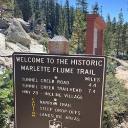
Tahoe Rim Trl
Carson City, NV 89701
Directions
Hours
Outdoor Amenities
Ask the Community - Spooner Lake Trailhead
Review Highlights - Spooner Lake Trailhead
You might also consider


Why does Yelp recommend reviews?
Spooner Lake Trailhead - hiking - Updated July 2026
Best of Carson City
People found Spooner Lake Trailhead by searching for…
Fishing in Carson City, Nevada
Campgrounds in Carson City, Nevada
Hiking Trails in Carson City, Nevada
Attractions in Carson City, Nevada
Natural Hot Springs in Carson City, Nevada
Boardwalk in Carson City, Nevada
Things to Do in Carson City, Nevada
Scenic View in Carson City, Nevada
Mountain Biking in Carson City, Nevada
Places to Take Pictures in Carson City, Nevada
Secret Spots in Carson City, Nevada
Easy Hikes in Carson City, Nevada
Swimming Lakes in Carson City, Nevada
Walking Trails in Carson City, Nevada
Snow Play in Carson City, Nevada
Off Road Trails in Carson City, Nevada
Hiking With Kids in Carson City, Nevada
Beaches in Carson City, Nevada
Picnic Areas in Carson City, Nevada
Water Parks for Kids in Carson City, Nevada
Fishing Lake in Carson City, Nevada
Trending Searches in Carson City, NV
Boat Rental near Spooner Lake Trailhead
Cliff Jumping near Spooner Lake Trailhead
Day Trips near Spooner Lake Trailhead
Dog Friendly Trails near Spooner Lake Trailhead
Dog Swimming near Spooner Lake Trailhead
Jet Ski Rental near Spooner Lake Trailhead
Kayak Rental near Spooner Lake Trailhead
Lakes & Ponds near Spooner Lake Trailhead
Off Road Trails near Spooner Lake Trailhead
Outdoor Activities near Spooner Lake Trailhead
Parks For Picnics near Spooner Lake Trailhead
Pool Day Pass near Spooner Lake Trailhead
Public Pools near Spooner Lake Trailhead
Public Shower near Spooner Lake Trailhead
River Swimming near Spooner Lake Trailhead
River Tubing near Spooner Lake Trailhead
Rock Quarry near Spooner Lake Trailhead
Scenic Night View near Spooner Lake Trailhead
Scenic Overlook near Spooner Lake Trailhead
Secluded Spots near Spooner Lake Trailhead
Soccer Store near Spooner Lake Trailhead
Splash Pad near Spooner Lake Trailhead
Strawberry Picking near Spooner Lake Trailhead
Sunrise View near Spooner Lake Trailhead
Swimming Holes near Spooner Lake Trailhead
Swimming Lakes near Spooner Lake Trailhead
Watch Sunset near Spooner Lake Trailhead
Browse Articles
Browse Nearby
BEST of Carson City, Nevada Restaurants near Spooner Lake Trailhead
BEST of Carson City, Nevada Coffee near Spooner Lake Trailhead
BEST of Carson City, Nevada Things to Do near Spooner Lake Trailhead
BEST of Carson City, Nevada Breakfast near Spooner Lake Trailhead
BEST of Carson City, Nevada Beaches near Spooner Lake Trailhead
BEST of Carson City, Nevada Bike Rentals near Spooner Lake Trailhead
Browse Brands
Related Searches in Carson City, NV
Affordable Kayak Rental Services in Carson City, Nevada
Best Dog Hiking Trails Around Carson City, Nevada
Best Fishing Locations and Guides in Carson City, Nevada
Best Places for Horseback Riding in Carson City, Nevada
Best Sightseeing Experiences Available in Carson City, Nevada
Check Out Off Road Trails in Carson City, Nevada
Discover Dog Friendly Trails to Explore in Carson City, Nevada
Discover Easy Hiking Trails Near Carson City, Nevada
Discover Kid Friendly Hiking Trails in Carson City, Nevada
Discover Popular Bike Trails in Carson City, Nevada
Discover Scenic Mountain Bike Trails Near Carson City, Nevada
Discover a Hiking Trail in Carson City, Nevada
Discover the Best Night Hike Trails in Carson City, Nevada
Dog-Friendly Hikes With Dogs in Carson City, Nevada
Enjoy Camping Adventures Around Carson City, Nevada
Enjoy Kayaking Adventures in Carson City, Nevada
Enjoy Off Leash Dog Hikes in Carson City, Nevada
Enjoy Scenic Places to Walk in Carson City, Nevada
Enjoy Tent Camping Spots Around Carson City, Nevada
Enjoy a Beautiful Waterfall Hike in Carson City, Nevada
Enjoy the Best Picnic Spots and Ideas in Carson City, Nevada
Enjoy the Best Walking Path in Carson City, Nevada
Enjoy the Best Walking Trails in Carson City, Nevada
Explore Easy Hikes Perfect for All in Carson City, Nevada
Explore Fun Activities to Do in Carson City, Nevada
Explore Popular Campgrounds Near Carson City, Nevada
Explore Popular State Park Destinations in Carson City, Nevada
Explore the Best Beach Spots in Carson City, Nevada
Family Friendly Hiking With Kids in Carson City, Nevada
Find Popular Ziplining Spots Around Carson City, Nevada
Find Top-Rated Waterfalls in Carson City, Nevada Now
Find the Best Playgrounds to Visit in Carson City, Nevada
Hiking Trails With Waterfalls in Carson City, Nevada
Off Leash Dog Hiking Trails in Carson City, Nevada
Play at a Splash Pad Park in Carson City, Nevada
Popular Outdoor Activities to Try in Carson City, Nevada
Popular Picnic Spots to Visit in Carson City, Nevada
Popular Waterfall Hiking Trails in Carson City, Nevada
Safe River Swimming Areas in Carson City, Nevada
Safe and Fun Parks for Kids in Carson City, Nevada
Top Hiking Trails to Explore in Carson City, Nevada
Top Playgrounds for Kids to Enjoy in Carson City, Nevada
Top Running Trails to Explore in Carson City, Nevada
Top Swimming Lakes to Enjoy in Carson City, Nevada
Top Swimming Spots and Pools in Carson City, Nevada
Top Things to Do With Kids in Carson City, Nevada
Top-Rated Camping Sites in Carson City, Nevada