Whale Beach Trail Photos


You might also consider
More like Whale Beach Trail
Recommended Reviews - Whale Beach Trail
Start your review...

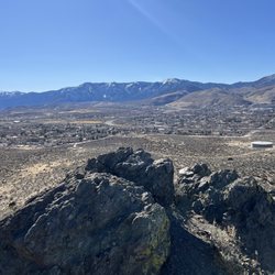
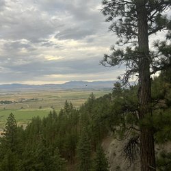
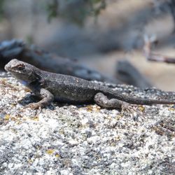
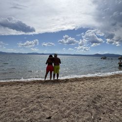
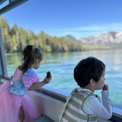
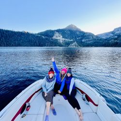
There's something so special about hiking in the beautiful Lake Tahoe area. Maybe it's the tall Tahoe Pines or the secluded beaches. Or maybe it's the views of the rocky coastline or rampant wildlife. Maybe it's the breathtaking trailheads and the smell of fresh pine that hits your nose. Whatever it is; I just love it. The Whale Beach Trail offers all of those lovable Tahoe accents that I love. I found this trail through the AllTrails app (Secret Cove Beach to Whale Cove Beach) and it was the perfect way to check out several secluded beaches along the way. The Secret Cove Beach to Whale Cove Beach Trail loop is a short 3 miles long, but it's a great way to hike down the beaches and relax along the way. You can take the shorter version of this trail which is just the Whale Beach Trail and it's about 1.5 miles long. I started at the parking lot above Chimney Beach. If you plan on starting here for the loop trail, get here before 8 am. Otherwise, parking will be full and you'll have to find a spot down the road. The trail starts off pretty easy along a single track sanded path through the beautiful pine woods. The trail begins to widen and open up to some wonderful views of the lake and gorgeous secluded beaches down below. The trail passes by several beach coves (Secret Cove, Secret Harbor {aka Boater's Beach}, Creek Beach, and Whale Beach) and ends at Whale Beach. Not a ton of elevation gain, but the ups and down of the path will give you a nice workout. Pair that with climbing to and from the beaches and you've got yourself a nice little moderate hike with plenty of exploration opportunities. Most people seem to use parts of these trails solely to get down to the beach. Because of this, the trail is relativity calm which leaves you with many opportunities to have the trail to yourself. It's mostly shaded with a few open spots to allow the sun to peek through. There are several restrooms along the trail and also near the beaches. Saw several birds and lizards all throughout the trail. It's super peaceful and gorgeous. A trail that I would come back to simply because it allows access to so many different beautiful beaches. Whale Beach itself is lovely and secluded with the clearest water and super soft sand. However, Sand Harbor Beach is by far the most beautiful of all the beach coves along this trail. It's also not nearly as crowded as Secret Cove which is a total relief. This was easily one of the most memorable Tahoe hikes that's I've done simply because the views are unparalleled. Such an amazing trail that you should check out sometime. read more


 - Hiking Near Me")


Our family LOVED this trail! Parking was a little rough. We ended up facing south on SR-28 on the side of the road. There are stairs down, so you should try to find those. (Not that they are much better than the rocks down, but they're something. ) We zig-zagged down the trail taking the farthest-most route to Whale Beach. There were other turn-offs that would have taken us to Secret Cove/ Boaters Beach/ etc, but we kept straight. I wouldn't say the trail is super-well marked, though. It helps to know where you're going (we used the All Trails map). We took our puppy, and she was off-leash most of the time. There were other dogs at the beach, so they had fun playing. We were excited to see parta potties as we got closer, too! (No wash stations, so BYOHS). The climb back is ... a workout. We we're able to take one path down, and another loop back - not that you can quite tell from the map picture as apparently my watch wasn't actually tracking the whole time. But, still fun! All of the kids (3, 7, 8, and 9) made it there and back without having to be carried. We have hiked before, but I wouldn't say we're expert level. So, it's doable! read more


More info about Whale Beach Trail
Carson City, NV 89703
Directions
Hours
Outdoor Amenities
You might also consider


Whale Beach Trail - hiking - Updated July 2026
Best of Carson City
People found Whale Beach Trail by searching for…
Beaches in Carson City, Nevada
Swimming Holes in Carson City, Nevada
Easy Hikes in Carson City, Nevada
Hiking Trails in Carson City, Nevada
Fun Things to Do With Kids in Carson City, Nevada
Swimming Lakes in Carson City, Nevada
Scenic View in Carson City, Nevada
Things to Do in Carson City, Nevada
Scenic Drive in Carson City, Nevada
Secret Spots in Carson City, Nevada
Fishing Ponds in Carson City, Nevada
Lakes & Ponds in Carson City, Nevada
Dog Beach in Carson City, Nevada
Marinas in Carson City, Nevada
Dog Swimming in Carson City, Nevada
Stairs Workout in Carson City, Nevada
Walking Trails in Carson City, Nevada
Beautiful Views in Carson City, Nevada
Secluded Spots in Carson City, Nevada
Off Leash Dog Hiking Trails in Carson City, Nevada
Bird Watching in Carson City, Nevada
Trending Searches in Carson City, NV
Boat Launch near Whale Beach Trail
Boat Rental near Whale Beach Trail
Cliff Jumping near Whale Beach Trail
Day Trips near Whale Beach Trail
Dog Friendly Trails near Whale Beach Trail
Dog Swimming near Whale Beach Trail
Fishing Spots near Whale Beach Trail
Jet Ski Rental near Whale Beach Trail
Kayak Rental near Whale Beach Trail
Lakes & Ponds near Whale Beach Trail
Off Road Trails near Whale Beach Trail
Outdoor Activities near Whale Beach Trail
Outdoor Basketball Courts near Whale Beach Trail
Paddle Boat Rentals near Whale Beach Trail
Parks For Picnics near Whale Beach Trail
Picnic Areas near Whale Beach Trail
Pool Day Pass near Whale Beach Trail
Public Pools near Whale Beach Trail
Public Shower near Whale Beach Trail
River Swimming near Whale Beach Trail
River Tubing near Whale Beach Trail
Rock Quarry near Whale Beach Trail
Running Trails near Whale Beach Trail
Scenic Night View near Whale Beach Trail
Scenic Overlook near Whale Beach Trail
Scenic Restaurants near Whale Beach Trail
Secluded Spots near Whale Beach Trail
Soccer Store near Whale Beach Trail
Splash Pad near Whale Beach Trail
Strawberry Picking near Whale Beach Trail
Sunrise View near Whale Beach Trail
Swimming Holes near Whale Beach Trail
Swimming Lakes near Whale Beach Trail
Volleyball Courts near Whale Beach Trail
Watch Sunset near Whale Beach Trail
Water Parks near Whale Beach Trail
Browse Nearby
BEST of Carson City, Nevada Restaurants near Whale Beach Trail
BEST of Carson City, Nevada Coffee near Whale Beach Trail
BEST of Carson City, Nevada Breakfast near Whale Beach Trail
BEST of Carson City, Nevada Things to Do near Whale Beach Trail
BEST of Carson City, Nevada Beaches near Whale Beach Trail
BEST of Carson City, Nevada Shopping near Whale Beach Trail
BEST of Carson City, Nevada Hot Springs near Whale Beach Trail
BEST of Carson City, Nevada Campgrounds near Whale Beach Trail
Browse Brands
Related Searches in Carson City, NV
Affordable Kayak Rental Services in Carson City, Nevada
Best Dog Hiking Trails Around Carson City, Nevada
Best Fishing Locations and Guides in Carson City, Nevada
Best Parks for Parties and Events in Carson City, Nevada
Best Places for Horseback Riding in Carson City, Nevada
Best Pontoon Boat Rentals Near Carson City, Nevada
Best Sightseeing Experiences Available in Carson City, Nevada
Check Out Off Road Trails in Carson City, Nevada
Discover Dog Friendly Trails to Explore in Carson City, Nevada
Discover Easy Hiking Trails Near Carson City, Nevada
Discover Kid Friendly Hiking Trails in Carson City, Nevada
Discover Lakes & Ponds to Explore in Carson City, Nevada
Discover Popular Bike Trails in Carson City, Nevada
Discover Public Beaches to Visit in Carson City, Nevada
Discover Scenic Mountain Bike Trails Near Carson City, Nevada
Discover Top Fishing Lakes in Carson City, Nevada for Your Next Trip
Discover a Hiking Trail in Carson City, Nevada
Discover the Best Beaches in Carson City, Nevada
Discover the Best Night Hike Trails in Carson City, Nevada
Dog-Friendly Hikes With Dogs in Carson City, Nevada
Enjoy Camping Adventures Around Carson City, Nevada
Enjoy Kayaking Adventures in Carson City, Nevada
Enjoy Off Leash Dog Hikes in Carson City, Nevada
Enjoy Scenic Places to Walk in Carson City, Nevada
Enjoy Tent Camping Spots Around Carson City, Nevada
Enjoy Water Activities and Fun in Carson City, Nevada
Enjoy a Beautiful Waterfall Hike in Carson City, Nevada
Enjoy the Best Picnic Spots and Ideas in Carson City, Nevada
Enjoy the Best Tubing Experiences in Carson City, Nevada
Enjoy the Best Walking Path in Carson City, Nevada
Enjoy the Best Walking Trails in Carson City, Nevada
Explore Beautiful Parks and Green Spaces in Carson City, Nevada
Explore Boat Rentals for Every Need in Carson City, Nevada
Explore Easy Hikes Perfect for All in Carson City, Nevada
Explore Fun Activities to Do in Carson City, Nevada
Explore Parks With Lakes to Visit in Carson City, Nevada
Explore Popular Campgrounds Near Carson City, Nevada
Explore Popular Picnic Areas Around Carson City, Nevada
Explore Popular RV Parks Around Carson City, Nevada
Explore Popular State Park Destinations in Carson City, Nevada
Explore Top Marinas Near Carson City, Nevada
Explore Top Water Parks in Carson City, Nevada Today
Explore the Best Beach Spots in Carson City, Nevada
Explore the Best Swimming Holes Around Carson City, Nevada
Explore the Scenic River in Carson City, Nevada
Family Friendly Hiking With Kids in Carson City, Nevada
Find Beautiful Views in Carson City, Nevada
Browse Articles
People who viewed Whale Beach Trail also viewed
Spooner Lake
18 reviews
Chimney Beach
62 reviews
Marlette lake trail
6 reviews
Kings Canyon Waterfall Trail
34 reviews
Tahoe Rim Trail to Picnic Rock Viewpoint
16 reviews
Lake Margaret
13 reviews
Tahoe Meadows
57 reviews
Genoa Loop Trail
4 reviews
Lake Tahoe Nevada State Park - Memorial Point
25 reviews
Prison Hill Recreation Area
7 reviews