Tahoe Rim Trail Photos


You might also consider
More like Tahoe Rim Trail
Recommended Reviews - Tahoe Rim Trail
Start your review...

Reviews With Photos

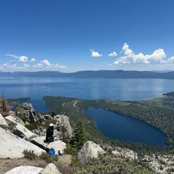
Beautiful Tahoe Rim Trail so stunning are the views. This is a 165 Mile hike around the Tahoe basin with elevation of 10,300 feet. We did a very small portion of this hike about 5 miles in and 5 mile journey out that connects to the Van Sickle connector hike which is 3.4 Miles. The views are breath taking and we encountered 5 small beautiful waterfalls on our journeys. I would love to complete more portions of this wonderful hike. Bring food, water, hat, bug spray, sunscreen and a good set of exceptional lungs and strong legs... lol... Tahoe Rim Trail is just what the Doctor ordered. Peace, beauty and serenity...

9/14/2018: It has taken me DECADES walking parts of the entire Tahoe Rim Trail, i.e., TRT . . . I wonder if, I'll ever finish hiking the entire trail? I have hiked parts of the Pacific Crest Trail which I think the Tahoe Rim Trail is an off-shoot of the Pacific Crest Trail . . . Here's the URL link: https://rootsrated.com/lake-tahoe-ca/hiking/tahoe-rim-trail-pacific-crest-trail-through-desolation-wilderness-hiking "Both the 2,650 mile Pacific Crest Trail and the 165 mile Tahoe Rim Trail share an approximately 22-miles segments of absolutely stunning trail through this breathtaking corner of Lake Tahoe. While I certainly can't speak for the entire PCT, this segment of the Tahoe Rim Trail is hands down the most scenic portion of an already stunning through hike." The TRT has twenty-two to thirty-nine miles hikes which requires at least, two weeks or more not working at all due to TRT's vastness in order, completing the 165-miles worth of stunning vistas: The expansive TRT requires applying for a wilderness permit so, you must stop by visiting "Ranger Rick" applying for you hiking permit. GO, go, go take a hike~literally!

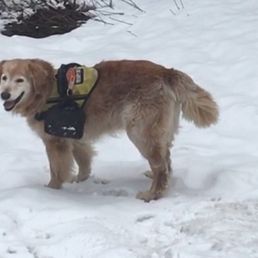
This trail holds a special place in my heart. My boyfriend and I took our husky puppy to Tahoe for a weekend, where he saw snow for the first time here! We drove around for a good spot and happened upon Tahoe Rim Trail, specifically the Kingsbury North one. In the section that Google Maps indicates, there's a good amount of parking, although... We were literally the only ones there. Hooray! Freedom! We had our puppy on a long leash and let him run around and experience snowfall. I'm interested in coming back here during the summer to do the actual hike when snow isn't covering the roads. Not sure if it gets crowded, but hikes seem pretty empty when you arrive first thing in the morning. And it's 30 minutes from where we usually stay, so not bad!

We hiked 10 miles this morning from the Ridge Resorts (near Heavenly ski resort) to Heavenly Village by the lake in South Lake Tahoe. A big portion of this was along the Tahoe Rim Trail, before we took the Van Sickle trail downhill. The Tahoe Rim Trail is quite flat, and easy for someone with a moderate fitness level. We left early (well before 7) to take advantage of the cool weather and shady trees, and enjoyed gorgeous views around every corner. I loved seeing all the new growth of pine trees. This bodes well as the sugar pines in the forest has been devastated by the blister rust fungus. We also spied deer and saw bear tracks (we think) and there were birds and signs of small wildlife everywhere. Would highly recommend this hike if you're staying anywhere near the Ridge.


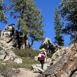
This part of The Tahoe Rim Trail is on Mt Rose. And probably is best described as a two part hike. The first being to the waterfall. And the second up to the summit of Mt Rose at 10,771 feet. The first to the waterfall is a moderate difficulty. The 2,300 elevation gain to the summit is probably best described as pleasant rather than challenging. October is a excellent month to take in the fall colors of the Sierras. As soon as you start your hike your able to taken beautiful Lake Tahoe. As the trail quickly becomes a extremely pleasant walk through pine tree, on a well maintained path. And the spectacular view continue all the wall the falls. The second part of the little over 10 mile hike, is of course to the summit. It's well worth the extra effort. The views are just breathtaking. A absolute wonderful way to spend a memorable afternoon.

I went on a portion of the Tahoe Rim Trail hike with two of my friends. Were a bit ambitious and decided to walk a portion of the trail (6 miles one way and 6 miles back). We stayed at an AirBnB off Cold Creek Trail and decided to carve our way towards Monument Peak. I started the "Hike" feature on my Apple Watch and watched as we started minute one of the hike. The time was middle of Fall, at about 1pm, when all the leaves are changing colors. The air was a degree colder than crisp but the sun had not set too early yet. I have to agree that this is the most stunning and beautiful hike I have ever been on. Every minute of the trail offered a new scenery. Especially during the beginning of the hike, I really understood why people love and can become one with nature. Halfway though our hike, we stopped by a meadow. It was beautiful, just like the ones you see in movies. Everything was clear, birds fluttering far away from the top of trees towards the faraway mountains. There was a pool of water where fish were swimming. A nice waterfall adjacent nearby with it's soothing sounds of water flowing. One of my friends was ambitious and wanted to press on. We agreed to about another hour (and what a tough hour that was). We started to make our way towards the California-Nevada border, and up what appears to be 500 feet per mile height from the green to the yellow on google maps. It was there that I had no more reception and my body knew that it was going to be sore for days. (Lucky for me one of our other friends had Tylenol at home). We ended the hike 11.5 miles later (I'm not sure how 0.5 miles got lost on the watch... maybe it got tired from counting for me too) and right as the sun started to set. The hike drained all our energy to the point where we needed dinner to be delivered to us. Very difficult but very accomplished. And this was only through a 6 mile segment of the trail. read more

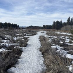
On our trip heading to Carson City from South Tahoe, we knew we would be passing the Tahoe Rim Trail and decided to make a quick hike. We parked on north side of Hwy 50 just west of the summit. There are limited parking spaces next to trailhead and there are no restroom facilities. There are several informational signs at the trailhead on the trails. You can hike into the Spooner Backcountry or on the Tahoe Rim Trail. With our schedule, we planned to hike a 6 miles loop. Having lightly snowed two nights before the trail had a light snow covering which made it a beautiful hike. From the trail, we had a view of Spooner Lake and Lake Tahoe. The trail took us through groves of trees and a rock formation. It was nice beautiful and serene short hike. Hope to be back so we can hike more of the Tahoe Rim Trail. read more


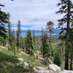
Of the 3 or 4 sections of the Tahoe Rim trail that I hiked, this section was the best; my wife concurred. It had the best and most consistent views of the lake along with gentle elevation gain and drop. The four sections of trail that we completed probably only accounted for about 10% of the 165 total trail miles, but of the 10%, this was the best hike. It would take a full year to hike the entire thing unless you really dedicated yourself. I wonder how many locals have hiked the entire trail. Probably only a small percentage. It would be enlightening to hear their perspective about their favorite sections. I hiked/ran four miles with about 1,000 feet of elevation gain. I was either getting in better shape and was unaware of the elevation or there was deceptively more gain than I initially realized. We waited until the last week to complete this section of the trail, which was visible from our rental and had significant snow accumulation for the majority of the month. Even after multiple weeks of 70s and 80s in the Carson Valley, there was still some snow on the trail. It was manageable and never hindered our hiking speed the way it did when we hiked the Tahoe Rim Trail our first week in Nevada. On that hike we had to steady ourselves up the snowbanks, making sure we didn't slid off, and avoid as many muddy sections as possible. read more


Beautiful Tahoe Rim Trail so stunning are the views. This is a 165 Mile hike around the Tahoe basin with elevation of 10,300 feet. We did a very small portion of this hike about 5 miles in and 5 mile journey out that connects to the Van Sickle connector hike which is 3.4 Miles. The views are breath taking and we encountered 5 small beautiful waterfalls on our journeys. I would love to complete more portions of this wonderful hike. Bring food, water, hat, bug spray, sunscreen and a good set of exceptional lungs and strong legs... lol... Tahoe Rim Trail is just what the Doctor ordered. Peace, beauty and serenity... read more


8 years ago
9/14/2018: It has taken me DECADES walking parts of the entire Tahoe Rim Trail, i.e., TRT . . . I wonder if, I'll ever finish hiking the entire trail? I have hiked parts of the Pacific Crest Trail which I think the Tahoe Rim Trail is an off-shoot of the Pacific Crest Trail . . . Here's the URL link: https://rootsrated.com/lake-tahoe-ca/hiking/tahoe-rim-trail-pacific-crest-trail-through-desolation-wilderness-hiking "Both the 2,650 mile Pacific Crest Trail and the 165 mile Tahoe Rim Trail share an approximately 22-miles segments of absolutely stunning trail through this breathtaking corner of Lake Tahoe. While I certainly can't speak for the entire PCT, this segment of the Tahoe Rim Trail is hands down the most scenic portion of an already stunning through hike." The TRT has twenty-two to thirty-nine miles hikes which requires at least, two weeks or more not working at all due to TRT's vastness in order, completing the 165-miles worth of stunning vistas: The expansive TRT requires applying for a wilderness permit so, you must stop by visiting "Ranger Rick" applying for you hiking permit. GO, go, go take a hike~literally! read more

9 years ago
This trail holds a special place in my heart. My boyfriend and I took our husky puppy to Tahoe for a weekend, where he saw snow for the first time here! We drove around for a good spot and happened upon Tahoe Rim Trail, specifically the Kingsbury North one. In the section that Google Maps indicates, there's a good amount of parking, although... We were literally the only ones there. Hooray! Freedom! We had our puppy on a long leash and let him run around and experience snowfall. I'm interested in coming back here during the summer to do the actual hike when snow isn't covering the roads. Not sure if it gets crowded, but hikes seem pretty empty when you arrive first thing in the morning. And it's 30 minutes from where we usually stay, so not bad! read more

We hiked 10 miles this morning from the Ridge Resorts (near Heavenly ski resort) to Heavenly Village by the lake in South Lake Tahoe. A big portion of this was along the Tahoe Rim Trail, before we took the Van Sickle trail downhill. The Tahoe Rim Trail is quite flat, and easy for someone with a moderate fitness level. We left early (well before 7) to take advantage of the cool weather and shady trees, and enjoyed gorgeous views around every corner. I loved seeing all the new growth of pine trees. This bodes well as the sugar pines in the forest has been devastated by the blister rust fungus. We also spied deer and saw bear tracks (we think) and there were birds and signs of small wildlife everywhere. Would highly recommend this hike if you're staying anywhere near the Ridge. read more


160 miles around Tahoe. Can access v near the Stagecoach Express lift. Large parking lot there. For those staying at Ridge, between tennis courts and Naegle 12 building, access too. Easy to moderate hiking at one's fingertips. Go for a while or a jaunt! read more


8 years ago
This part of The Tahoe Rim Trail is on Mt Rose. And probably is best described as a two part hike. The first being to the waterfall. And the second up to the summit of Mt Rose at 10,771 feet. The first to the waterfall is a moderate difficulty. The 2,300 elevation gain to the summit is probably best described as pleasant rather than challenging. October is a excellent month to take in the fall colors of the Sierras. As soon as you start your hike your able to taken beautiful Lake Tahoe. As the trail quickly becomes a extremely pleasant walk through pine tree, on a well maintained path. And the spectacular view continue all the wall the falls. The second part of the little over 10 mile hike, is of course to the summit. It's well worth the extra effort. The views are just breathtaking. A absolute wonderful way to spend a memorable afternoon. read more


5 years ago
8 years ago
Snow!! Nice trails, great climate, scenic views, good exercise. Can't believe it intersects with Heavely lifts! read more


7 years ago
11 years ago
Backpacked into star lake with about 6 others. I must say that while carrying a 35-40lbs pack it gets to be draining. 9 miles with much of it incline with many cutbacks. Once we made it to Star Lake though it made the trip well worth it. Beautiful lake with lots of fish and not many people at all. I believe there was one other little group of four people there but where we set up camp you couldn't even see them. read more


9 years ago
11 years ago

More info about Tahoe Rim Trail
455 Tramway Dr
Stateline, NV 89449
Directions
Hours
Outdoor Amenities
Ask the Community - Tahoe Rim Trail
Review Highlights - Tahoe Rim Trail
You might also consider


Tahoe Rim Trail - hiking - Updated August 2026
Best of Stateline
People found Tahoe Rim Trail by searching for…
Hiking Trails in Stateline, NV
Off Road Trails in Stateline, NV
Walking Trails in Stateline, NV
Waterfall Hike in Stateline, NV
Running Trails in Stateline, NV
Dog Friendly Trails in Stateline, NV
Parks for Kids in Stateline, NV
Scenic Overlook in Stateline, NV
Beaches for Kids in Stateline, NV
Mountain Biking in Stateline, NV
Off Leash Dog Hikes in Stateline, NV
Trending Searches in Stateline, NV
Cliff Jumping near Tahoe Rim Trail
Dog Friendly Things To Do near Tahoe Rim Trail
Dog Swimming near Tahoe Rim Trail
Indoor Mini Golf near Tahoe Rim Trail
Jet Ski Rental near Tahoe Rim Trail
Kayak Rental near Tahoe Rim Trail
Kids Activities Indoor near Tahoe Rim Trail
Outdoor Activities near Tahoe Rim Trail
Picnic Areas near Tahoe Rim Trail
Rainy Day Activities near Tahoe Rim Trail
River Swimming near Tahoe Rim Trail
Rock Quarry near Tahoe Rim Trail
Scenic Overlook near Tahoe Rim Trail
Shopping Malls near Tahoe Rim Trail
Sunrise View near Tahoe Rim Trail
Surf Shop near Tahoe Rim Trail
Swimming Holes near Tahoe Rim Trail
Things To Do On A Rainy Day near Tahoe Rim Trail
Browse Articles
Browse Nearby
BEST of Stateline, Nevada Restaurants near Tahoe Rim Trail
BEST of Stateline, Nevada Coffee near Tahoe Rim Trail
BEST of Stateline, Nevada Walking Trails near Tahoe Rim Trail
BEST of Stateline, Nevada Things to Do near Tahoe Rim Trail
BEST of Stateline, Nevada Parks near Tahoe Rim Trail
BEST of Stateline, Nevada Breakfast near Tahoe Rim Trail
BEST of Stateline, Nevada Sledding near Tahoe Rim Trail
Browse Brands
Related Searches in Stateline, NV
Affordable Kayak Rental Services in Stateline, Nevada
Best Dog Hiking Trails Around Stateline, Nevada
Best Fishing Locations and Guides in Stateline, Nevada
Best Places for Horseback Riding in Stateline, Nevada
Best Sightseeing Experiences Available in Stateline, Nevada
Best Sledding Spots and Fun in Stateline, Nevada
Discover Dog Friendly Trails to Explore in Stateline, Nevada
Discover Easy Hiking Trails Near Stateline, Nevada
Discover Kid Friendly Hiking Trails in Stateline, Nevada
Discover Popular Bike Trails in Stateline, Nevada
Discover Scenic Mountain Bike Trails Near Stateline, Nevada
Discover a Hiking Trail in Stateline, Nevada
Discover the Best Night Hike Trails in Stateline, Nevada
Dog-Friendly Hikes With Dogs in Stateline, Nevada
Enjoy Camping Adventures Around Stateline, Nevada
Enjoy Exciting Mountain Biking Adventures in Stateline, Nevada
Enjoy Kayaking Adventures in Stateline, Nevada
Enjoy Off Leash Dog Hikes in Stateline, Nevada
Enjoy Tent Camping Spots Around Stateline, Nevada
Enjoy a Beautiful Waterfall Hike in Stateline, Nevada
Enjoy the Best Picnic Spots and Ideas in Stateline, Nevada
Enjoy the Best Walking Trails in Stateline, Nevada
Experience Thrilling White Water Rafting in Stateline, Nevada
Explore Easy Hikes Perfect for All in Stateline, Nevada
Explore Fun Activities to Do in Stateline, Nevada
Explore Popular Campgrounds Near Stateline, Nevada
Explore Popular State Park Destinations in Stateline, Nevada
Explore Top Dog Parks in Stateline, Nevada Near You
Explore the Best Beach Spots in Stateline, Nevada
Family Friendly Hiking With Kids in Stateline, Nevada
Find Beautiful Views in Stateline, Nevada
Find Fun Kids Activities Outdoor in Stateline, Nevada
Find Parks and Recreation Activities in Stateline, Nevada
Find Popular Ziplining Spots Around Stateline, Nevada
Find Top Dog Friendly Parks to Visit in Stateline, Nevada
Find Top-Rated Waterfalls in Stateline, Nevada Now
Hiking Trails With Waterfalls in Stateline, Nevada
Off Leash Dog Hiking Trails in Stateline, Nevada
Popular Outdoor Activities to Try in Stateline, Nevada
Popular Picnic Spots to Visit in Stateline, Nevada
Popular Waterfall Hiking Trails in Stateline, Nevada
Safe and Fun Parks for Kids in Stateline, Nevada
Top Hiking Trails to Explore in Stateline, Nevada
Top Playgrounds for Kids to Enjoy in Stateline, Nevada
Top Running Trails to Explore in Stateline, Nevada
Top Swimming Spots and Pools in Stateline, Nevada
Top Things to Do With Kids in Stateline, Nevada