Genoa Loop Trail Photos

 Didn't make it up to the waterfall but still worth the view. - Hiking Near Me - Carson City, Nevada")


You might also consider
More like Genoa Loop Trail
Recommended Reviews - Genoa Loop Trail
Start your review...

It's been years since I last hiked this loop on a hot Summer day in July. This is a steep trail and there are parts that narrowed out, but hubby and I walked single file through those parts. We spent a day hanging out here, but we stopped halfway for a break and lunch in some shade. There are plenty of little rivers that flow below the waterfall. Hearing the waterfall kept us chugging along because we were ready to cool off. This wasn't the biggest waterfall, but we enjoyed our time in it. It was very private once we actually got down there and so happy we were in our own little oasis; we had the whole place to ourselves. With all the precipitation we received this year I can only imagine how beautiful and full everything is. I'm planning on revisiting this Summer to see how everything has grown. read more


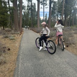
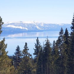
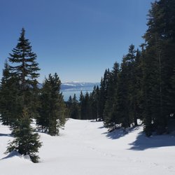
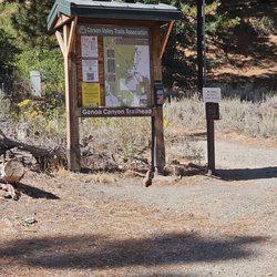
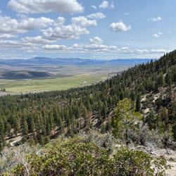
Beautiful hike, spectacular views with a waterfall, this hike offers up rewarding treasures that only Genoa can deliver. We set off on this trail that starts in the historic town of Genoa at the end of Carson Street which is north of Main Street (same side as the Genoa Bar - look for the Orchard House). You will see a gravel parking lot and the Genoa Loop Trail sign at the start of the trail. We opted for the 6 mile round trip to the waterfall adventure on this particular day as we headed out. With an elevation gain of 1410ft and many switchbacks be sure to carry plenty of H20, wear appropriate footwear, maybe bring something like a granola bar or fruit and as always pack out, what you pack in. The trail is well maintained, but can be narrow & steep at times with bicyclists and furry companions allowed on the trail too. Please be sure to bring leashes along with doggy mutt mitts aka poop bags, there is a trash can and mutt mitts at the beginning of the trail but better to be prepared and there are no poop fairies. Remember everyone is out there to enjoy the beauty of the Great Outdoors so ENJOY IT! We thoroughly enjoyed this hike, stopping along the way to take in the spring flowers, beautiful views, grab our binoculars to look upon Genoa, the Carson River & Jacks Valley. We crossed the creek throughout the trail with foot bridges, butterflies, and the reward of our hiking adventure was the Genoa Waterfall as it cascade over as we listened to it surrounded by the pine trees. So get out there, this is a GREAT waterfall hike with stunning views added bonus you are already in the quaint historic town of Genoa so why not check out the cute town and grab a bite to eat or libation. Enjoy and #moveyourbody!! read more


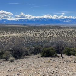
The Genoa Loop Trail is really three trails that are all connected at the top and eventually lead to the Tahoe Rim Trail. Many of the trails in the Tahoe area do a great job of connecting to other trails so you could effectively walk forever without touching pavement. Fortunately, I was able to experience all three of the trails in the Genoa Loop. Because I only hiked them after work for an hour or two, I never made it to their connecting point. Also, the trails are steep. From the moment you hit the trail, its up, up, up. A full evening workout might be 3 miles and 1,000 feet of elevation gain. I would've had to reach 2,000 feet of elevation gain to make it to the connector. Consistent with other trails in the Carson Valley Trail Association, these trails are expertly made and maintained. They are cut into the side of the steep Sierra Nevadas on precarious terrain, yet they still feel solid. I would only feel unsafe on these trails if I was on a bike. Some sections are skinnier than single track; they are what I might call half-track. You don't want to miss the track, because if you do, you can only pray that you hit a tree on the way down. I met one old man biking down the steepest of the three trails as I was going up. He said, "Steep trails, huh?" as he walked his bike around a turn. "Yup!" read more


2 years ago
Amazing views!! There was a Waterfall but we sadly didn't make it, due to getting there pretty late! But the view walking up is so beautiful and the sunset was the cherry on top :) read more


More info about Genoa Loop Trail
100 Genoa Canyon Rd
Carson City, NV 89705
Directions
Hours
Outdoor Amenities


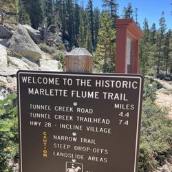
Genoa Loop Trail - hiking - Updated June 2026
Best of Carson City
People found Genoa Loop Trail by searching for…
Hiking Trails With Waterfalls in Carson City, Nevada
Things to Do in Carson City, Nevada
Scenic View in Carson City, Nevada
Walking Trails in Carson City, Nevada
Sunset View in Carson City, Nevada
Off Road Trails in Carson City, Nevada
Running Trails in Carson City, Nevada
Waterfalls and Swimming Holes in Carson City, Nevada
Beautiful Views in Carson City, Nevada
Waterfalls in Carson City, Nevada
Off Leash Dog Hiking Trails in Carson City, Nevada
View Points in Carson City, Nevada
Bike Paths in Carson City, Nevada
Scenic Overlook in Carson City, Nevada
Fun Things to Do for a Birthday in Carson City, Nevada
Bicycle Shop in Carson City, Nevada
Things to Do This Weekend in Carson City, Nevada
Watch Sunset in Carson City, Nevada
Trending Searches in Carson City, NV
4th Of July Fireworks near Genoa Loop Trail
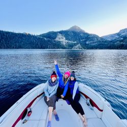
Boat Rental near Genoa Loop Trail
Cliff Jumping near Genoa Loop Trail
Day Trips near Genoa Loop Trail
Dog Friendly Trails near Genoa Loop Trail
Fireworks near Genoa Loop Trail
Fishing Spots near Genoa Loop Trail
Jet Ski Rental near Genoa Loop Trail
Kayak Rental near Genoa Loop Trail
Lakes & Ponds near Genoa Loop Trail
Lookout Points near Genoa Loop Trail
Mountain Biking near Genoa Loop Trail
Outdoor Activities near Genoa Loop Trail
Picnic Areas near Genoa Loop Trail
Public Pools near Genoa Loop Trail
Public Shower near Genoa Loop Trail
River Swimming near Genoa Loop Trail
Rock Quarry near Genoa Loop Trail
Scenic Night View near Genoa Loop Trail
Scenic Overlook near Genoa Loop Trail
Secluded Spots near Genoa Loop Trail
Soccer Store near Genoa Loop Trail
Splash Pad near Genoa Loop Trail
Star Gazing near Genoa Loop Trail
Strawberry Picking near Genoa Loop Trail
Sunrise View near Genoa Loop Trail
Swimming Holes near Genoa Loop Trail
Swimming Lakes near Genoa Loop Trail
Watch Sunset near Genoa Loop Trail
Water Parks near Genoa Loop Trail
Browse Articles
Browse Nearby
BEST of Carson City, Nevada Restaurants near Genoa Loop Trail
BEST of Carson City, Nevada Coffee near Genoa Loop Trail
BEST of Carson City, Nevada Breakfast near Genoa Loop Trail
BEST of Carson City, Nevada Things to Do near Genoa Loop Trail
BEST of Carson City, Nevada Shopping near Genoa Loop Trail
BEST of Carson City, Nevada Hot Springs near Genoa Loop Trail
BEST of Carson City, Nevada Thrift Stores near Genoa Loop Trail
Browse Brands
Related Searches in Carson City, NV
Affordable Bike Repair Services in Carson City, Nevada
Affordable Bike Tune Up Services in Carson City, Nevada
Affordable Kayak Rental Services in Carson City, Nevada
Affordable Road Bike Rental in Carson City, Nevada
Affordable Tandem Bike Rental in Carson City, Nevada
Best Dog Hiking Trails Around Carson City, Nevada
Best Electric Bike Rental Services in Carson City, Nevada
Best Fishing Locations and Guides in Carson City, Nevada
Best Places for Horseback Riding in Carson City, Nevada
Best Sledding Spots and Fun in Carson City, Nevada
Best Used Bikes for Sale Near Carson City, Nevada
Check Out Off Road Trails in Carson City, Nevada
Discover Dog Friendly Trails to Explore in Carson City, Nevada
Discover Kid Friendly Hiking Trails in Carson City, Nevada
Discover Popular Bike Tours in Carson City, Nevada
Discover Scenic Bike Paths in Carson City, Nevada
Discover Scenic Mountain Bike Trails Near Carson City, Nevada
Discover Scenic Waterfall Spots in Carson City, Nevada
Discover a Hiking Trail in Carson City, Nevada
Discover the Best Night Hike Trails in Carson City, Nevada
Dog-Friendly Hikes With Dogs in Carson City, Nevada
Enjoy Biking Adventures Around Carson City, Nevada
Enjoy Camping Adventures Around Carson City, Nevada
Enjoy Exciting Mountain Biking Adventures in Carson City, Nevada
Enjoy Hiking Adventures in Carson City, Nevada
Enjoy Kayaking Adventures in Carson City, Nevada
Enjoy Tent Camping Spots Around Carson City, Nevada
Enjoy a Beautiful Waterfall Hike in Carson City, Nevada
Enjoy the Best Picnic Spots and Ideas in Carson City, Nevada
Enjoy the Best Tubing Experiences in Carson City, Nevada
Enjoy the Best Walking Path in Carson City, Nevada
Enjoy the Best Walking Trails in Carson City, Nevada
Experience Thrilling White Water Rafting in Carson City, Nevada
Explore BMX Bike Shops Near Carson City, Nevada
Explore Beautiful Parks and Green Spaces in Carson City, Nevada
Explore Bike Rentals Throughout Carson City, Nevada
Explore Easy Hikes Perfect for All in Carson City, Nevada
Explore Electric Bikes Available in Carson City, Nevada
Explore Fun Activities to Do in Carson City, Nevada
Explore Popular Campgrounds Near Carson City, Nevada
Explore Popular Scenic Overlook Points in Carson City, Nevada
Explore Scenic Lakes to Visit in Carson City, Nevada
Explore Secret Spots Worth Visiting in Carson City, Nevada
Explore the Best Beach Spots in Carson City, Nevada
Explore the Best Boating Spots in Carson City, Nevada
Explore the Best Swimming Holes Around Carson City, Nevada
Explore the Best Trail Options in Carson City, Nevada
Family Friendly Hiking With Kids in Carson City, Nevada