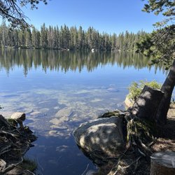
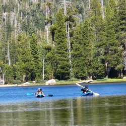
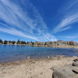
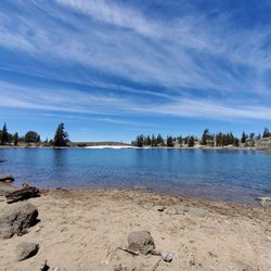
Meiss Trailhead Photos


You might also consider
More like Meiss Trailhead
Recommended Reviews - Meiss Trailhead
Start your review...

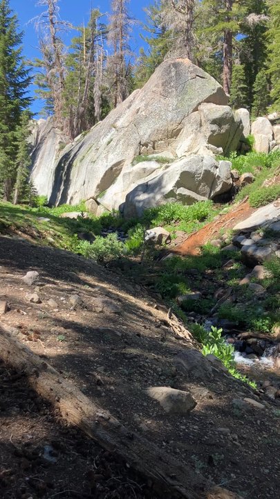
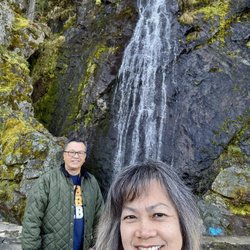
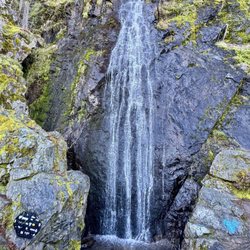
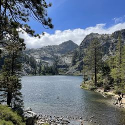
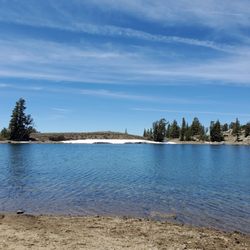
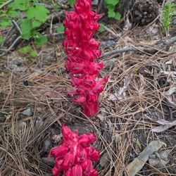
July 3, 2025. 13.7 miles. Started at Meiss trailhead on Carson pass heading toward Echo Summit. The approach up to the saddle of Meiss meadow is a good little warm-up. Along the entire trail there are millions of wildflowers! In some spots, the Mules Ear is 4 feet tall and there are Lupine and other wildflowers intermingled with it. Saw so many butterflies as well. The creeks are running well and the breeze that we had helped keep any bugs away. There were only a couple patches of snow left, they will probably be gone in a few weeks. Coming out of Bryan Meadow the steady grade will remind you that you have logged a few miles already. The descent for the last couple miles is rocky and steep. I definitely recommend having hiking poles to help save your knees. Overall, it was a beautiful hike with fantastic views of the valleys and Lake Tahoe. read more


2 years ago
It's technically a trailhead and a Sno-Park, but leave your sleds and snowmobiles behind for this one. The biggest draw is that the Pacific Crest Trail (PCT) is steps away. Many miles of scenic trail are beyond this trailhead! Located a minute down the road from the other Sno-Park/trailhead (Carson Pass), this is a much bigger parking lot and would be my first choice between the two. There are also two well-maintained vault toilets here. Don't forget your day pass or season snow park pass [November 1 - May 30] because the fee station is going to be buried under snow and oh yeah they patrol and ticket. "Any vehicle parked at a SNO-Park site without a permit properly displayed is subject to an $94.50 fine." Happy Trails! read more


12 years ago
We have enjoyed the hike and views of the Sierras from the trail. Its also a good place for snow play. Its also close enough to Caples Lake, where we go fishing, for a last minute "pit stop" on other outings. read more


More info about Meiss Trailhead
Hwy 88
Kirkwood, CA 95646
Directions
Hours
Outdoor Amenities
You might also consider


Meiss Trailhead - hiking - Updated May 2026
Best of Kirkwood
People found Meiss Trailhead by searching for…
Off Leash Dog Hikes in Kirkwood, CA
Fun Places to Go in Kirkwood, CA
Running Trails in Kirkwood, CA
Scenic Restaurants in Kirkwood, CA
Walking Trails in Kirkwood, CA
Fun Things to Do With Kids in Kirkwood, CA
Park & Forests in Kirkwood, CA
Off Road Trails in Kirkwood, CA
Trending Searches in Kirkwood, CA
Botanical Gardens near Meiss Trailhead
Bounce House Rentals near Meiss Trailhead
Campgrounds near Meiss Trailhead
Cherry Picking near Meiss Trailhead
Cliff Jumping near Meiss Trailhead
Dog Friendly Things To Do near Meiss Trailhead
Flower Shop near Meiss Trailhead
Garage Sales near Meiss Trailhead
Garden Center near Meiss Trailhead
Graduation Leis near Meiss Trailhead
Lakes & Ponds near Meiss Trailhead
Nurseries & Gardening near Meiss Trailhead
Outdoor Activities near Meiss Trailhead
Outdoor Furniture Stores near Meiss Trailhead
Party Equipment Rentals near Meiss Trailhead
Photo Spots near Meiss Trailhead
Picnic Areas near Meiss Trailhead
Places To Take Pictures near Meiss Trailhead
Rock Quarry near Meiss Trailhead
Running Trails near Meiss Trailhead
Rv Rental near Meiss Trailhead
Spray Tanning near Meiss Trailhead
Sunrise View near Meiss Trailhead
Swimming Holes near Meiss Trailhead
Table And Chair Rentals near Meiss Trailhead
Browse Articles
Browse Nearby
Browse Brands
Related Searches in Kirkwood, CA
Affordable Kayak Rental Services in Kirkwood, California
Best Fishing Locations and Guides in Kirkwood, California
Best Places for Horseback Riding in Kirkwood, California
Best Sledding Spots and Fun in Kirkwood, California
Best Waterfalls and Swimming Holes in Kirkwood, California
Check Out Off Road Trails in Kirkwood, California
Discover Dog Friendly Trails to Explore in Kirkwood, California
Discover Kid Friendly Hiking Trails in Kirkwood, California
Discover Scenic Waterfall Spots in Kirkwood, California
Discover a Hiking Trail in Kirkwood, California
Discover the Best Night Hike Trails in Kirkwood, California
Dog-Friendly Hikes With Dogs in Kirkwood, California
Enjoy Camping Adventures Around Kirkwood, California
Enjoy Kayaking Adventures in Kirkwood, California
Enjoy a Beautiful Waterfall Hike in Kirkwood, California
Enjoy the Best Tubing Experiences in Kirkwood, California
Enjoy the Best Walking Trails in Kirkwood, California
Exciting Cliff Jumping Spots in Kirkwood, California
Explore Beautiful Parks and Green Spaces in Kirkwood, California
Explore Easy Hikes Perfect for All in Kirkwood, California
Explore Fun Activities to Do in Kirkwood, California
Explore Nature Spots Around Kirkwood, California
Explore Popular Campgrounds Near Kirkwood, California
Explore Top Dog Parks in Kirkwood, California Near You
Explore the Best Beach Spots in Kirkwood, California
Explore the Best Boating Spots in Kirkwood, California
Explore the Best Swimming Holes Around Kirkwood, California
Explore the Best Trail Options in Kirkwood, California
Family Friendly Hiking With Kids in Kirkwood, California
Find Beautiful Views in Kirkwood, California
Find Cozy Camping Cabins in Kirkwood, California
Find Parks and Recreation Activities in Kirkwood, California
Find Popular Ziplining Spots Around Kirkwood, California
Find the Best Scenic View Locations in Kirkwood, California
Hiking Trails With Waterfalls in Kirkwood, California
Off Leash Dog Hiking Trails in Kirkwood, California
Popular Fishing Spots to Explore in Kirkwood, California
Popular Outdoor Activities to Try in Kirkwood, California
Popular Picnic Spots to Visit in Kirkwood, California
Popular Things to Do in Kirkwood, California
Safe and Fun Parks for Kids in Kirkwood, California
Top Climbing Spots and Gyms in Kirkwood, California
Top Paddleboarding Activities in Kirkwood, California
Top Playgrounds for Kids to Enjoy in Kirkwood, California
Top Running Trails to Explore in Kirkwood, California
Top Swimming Lakes to Enjoy in Kirkwood, California
Top Swimming Spots and Pools in Kirkwood, California
Top Things to Do With Kids in Kirkwood, California