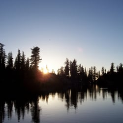
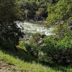
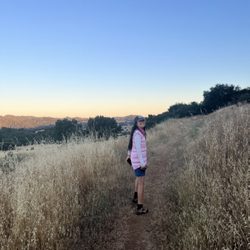
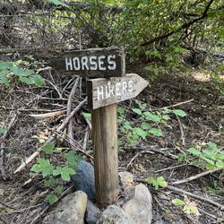
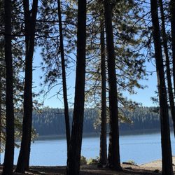
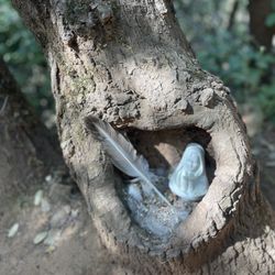
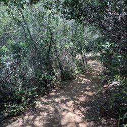
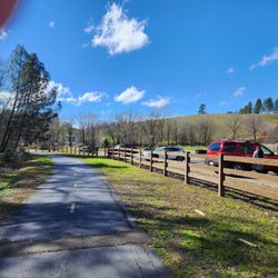
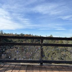
Bassi Falls Photos


You might also consider
More like Bassi Falls
Recommended Reviews - Bassi Falls
Start your review...

Reviews With Photos

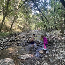
Such a beautiful place! Located near Ice House and in Pollock Pines - it's a must see! The hike is about 4.5 miles round trip and is pretty easy - there were only a few small inclines. Bassi Falls is huge - lots of little areas to swim. The water was freezing, but well worth the hike and a quick dip. We could have spent hours here! Pack lunch and make a day of it! I highly recommend checking it out. We will definitely be back next month when we go camping again!

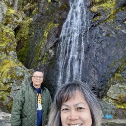
Bassi Falls is located in the El Dorado National Forest not far from Pollock Pines. Using GPS to get to the trailhead can be confusing so I found that using directions from other trail goers posts was helpful. You exit on Ice House Road from Highway 50 and take that about 16 miles. Once you go over a bridge around mile 16, on the left there is the signed Big Silver Group Camp. On the right there is an unmarked road, which you will turn on, taking you to the trail. There's no signage pointing to this being "the" road to take. Go straight once you're on this road for the longer route to the falls. It comes to a dead end and there's parking that's quite obvious. There's also a right turn down a pretty rutted road leading to the campground near the trailhead if you want to take a chance and take your car down there. I have a low clearance car, so I opted to park up top and it's a pretty short walk. Now for the good part-the hike itself!! It was kind of a gloomy, chilly Saturday so it wasn't too crowded. Mid May is a great time to come and see the creek flowing heavily and some little wildflowers coming in. It's a fairly flat and obvious trail that's well traveled. You can also look for trail blazes on the trees. There are times you veer away from the creek and are in the woods and other parts of the trail with epic mini falls before you get to the main event. The trail ends at some pretty magnificent falls. There are lots of rocks and areas to sit and enjoy the views, so pack a lunch and linger to enjoy it! It's about 4 miles round trip but worth the drive out for the spectacular falls in the spring. That's the time to go, as I've read they run to a trickle as the warmer months come in. Great hike to be in the mountains but not have to head all the way in to Tahoe. Would do again.

Long snow route in April 2023. It seems that there are 3 parking areas, but I think parking is only available near phere until May: 38.88155, -120.36032. There are green/blue markers but you've really got to look for it. Follow the footprints for a good gauge of a safe route, and be safe if you choose to take this snowy path. Snow is melting at the bottom; It will take you two times longer. Tip for partial snowy hiking routes: pack gaiters/snow shoes/ hiking sticks/work gloves/change of clothes and socks

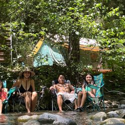
Needing to get out of our house and away from the city for a little while, we made our way up to Bassi Falls for a hike. It looked like every other person had the same idea; even with the parking lot closed at the trailhead itself, there were several cars parked on the sides of the street. After finding a parking spot ourselves, we made our way to the trailhead and up to the falls. Everyone was super respectful of social distancing out on the trail and at the falls. It was so nice to be outside, with fresh air and sunshine. The falls were flowing, despite a mild winter/small snow-pack. We laid out at the falls before making our way back down. Of note, besides the parking lot being closed, all restrooms are closed, and parts of the trail still had snow and/or were flooded. Just be mindful as you make your way up to the falls.
")
(COVID-19 REVIEW) My family and I decided to embark on our first Waterfall Hike at Bassi Falls on a hot Saturday (7/18/20). I read the most up to date yelp reviews to make sure we started at the right place...boy was I misled. For that reason, I want to make sure everyone who are interested in hiking are well aware of some things I wasn't. 1. Keep driving up. The paved road is pretty tight and you can't park on the north end of the road. You'll see a bunch of cars lined up on the side and I'll suggest you park there. 2. There's three trails. There's one that goes more upward at the top of the falls. You'll see a trail dedicated to it straight ahead on the left of the dirt paved road. There's an easier trail that is unmarked, but you have to get passed all the cars parked next to the campground. Ask locals. People are happy to help you out. The trail we took was called the Diamond Head and it was mediocre. We thought it was easier trail based on the Yelp reviews...wrong. For me, it was hard just because it was pretty steep and I was giving up. Its definitely family friendly though! 3. Not a lot of people were wearing masks. Just be aware and stay safe. 4. Be careful of all the logs laying around, especially if you have children! You might trip of them and it's not fun (happened to my mom). Overall, the journey was difficult but fun. I had a fun time once we got to the falls. There's plenty of hidden areas and creeks you can have a picnic at or get away from groups of people. The water is also COLD but refreshing. My family and I just did a picnic at one of the big rocks in the shade that had a direct view of falls and it was beautiful. I wouldn't come here in the summer time though because the falls was only a trickle of water! I would've came here in March/April for more water flow.

Hiked bassi again yesterday (Saturday 7/18) and found an easier trail. "Easier" because it was much more defined and thus less likely to get lost like we did the first time. Finding this trail made me love this hike even more. Sadly around this time of year the falls were really sparse. It was a trickle compared to what it was when we first visited in May. But there are still some mini swimming pools you can find on the way there and under the falls. Just go on a week day when there isn't a ton of people. Key things: -GET. THERE. EARLY. I cannot stress this enough. Especially on a weekend. We got there at 9am and there already wasn't parking in the lot. As we were walking back around 12pm we passed 3 huge groups of people heading to the falls. When we reached the parking lot, it was completely congested with people trying to find parking on the side of the roads. -Easy enough for kids and dogs. We had a pregnant lady in our group and also brought my sister's dog who both had no trouble doing this hike. - The trail starts in the parking lot. Walk towards the very end of it where you'll find huge rocks preventing cars from parking further. Walk passed these boulders and you'll find a trail. -No parking fee.

This trail is located near Ice House. I used All trails to navigate which took me right to the location. Because we took our little puppy we decided to park at the end of gravel road. It only took us 40 minutes to arrive at the falls. This place is beyond beautiful!! Honestly, I would love to check it out during the week when it's not busy! I've always wanted to skinny dip! It's pretty sexy here! Hahah

Bassi Falls is definitely a great hike when it comes to views and hiking level. The panoramic views were amazing and I enjoyed all the beautiful scenery nature has to offer .We got lost and got there really late around 2 or 3pm and noticed it wasn't busy at all which was a plus! Parking is limited and lucky for us people were leaving, but I could imagine how packed it can be if we came earlier. It was great enjoying the gorgeous landscape and the water. It gets very slippery climbing the rocks getting to the falls so I would suggest shoes with good grip. Bring your lunch sit out relax on the rocks and relax and take pics. I forgot there were a lot of ants around, I'm not sure what kind but maybe Carpenter Ants? I still would def come back again for the views

First of all I want to start this review by saying it is a bit confusing finding the trailhead for Bassi Falls. My gps told me to park on the side of the highway next to the bridge. This is in fact not the case! Cross the bridge, turn right on the gravel road and follow this road all the way up to the trailhead! The trail itself was easy to hike. About 2 miles into the falls and 2 miles back to the car. My 4 year old daughter did this hike with no problem! Beautiful scenery along the way. There are a few places you can look out and get down to the water and rapids. Please be careful. Once reaching the falls you will not be disappointed. Basis Falls is amazing. You can climb up to the falls to get a better look. But once again please be careful! There are little ponds which it goes into that you could swim in. I went in the beginning of July and the water was still freezing. Rocks can be very slippery and dangerous so be careful if you bring your little ones along.

So all the reviews across multiple sites did not prepare us for the obstacles we endured. Because of the weather conditions we had to navigate through snow , mud and fallen trees. There really wasn't a clear trail to follow so we just followed footsteps left by those who went before us lol . We didn't make it to the falls but got to enjoy nature. I wouldn't recommend kids for this hike during the winter months. Hope this helps any .

When I arrived on the trail toward the falls, there was a wait because a truck had tried to turn around and got stuck and nearly toppled off the cliff. The truck required 10-15 people to strategically move the car. Please do not try to turn your car midway on the dirt trail. There is not enough room to do this. The only way to turn your car around is to head toward a parking area up further on the road and turn your car around at that parking spot. Once the car was freed and no longer blocking the path I headed toward Bassi Falls with my friends. The road is unpaved and there are huge holes in the dirt road. This made access to Bassi Falls an inconvenience. We parked our car at the parking area and could not venture forth because of the holes in the road. Once parked, we hiked about 2.5 miles to Bassi Falls. Upon arrival, the waterfalls were so beautiful and worth the hike to get there. The area is dog friendly, however, there are many people there on the weekend. There are two beautiful primary waterfall source and some people have climbed up to the highest waterfall to explore. There are also many water holes down the way. The further away from the waterfall, the warmer the water hole. There were fish in the water holes also! MY friends and I got lost when we left Bassi Falls because we steered off the trail. When we realized we made an error in our judgement, we continued forward thinking it was a shortcut. Please remember to visually observe brushes and specific trees when on the trail to enter the falls so as to not veer off the path. As we ventured forth, we realized we were deeper in the Forrest and the air became more dense. Since we were losing light quickly, we decide to hike back to the trail rather than proceed further into the Forrest. Best decision of our lives. I can see how people get easily stranded in horror movies. What should have taken us 15 minutes to return back to our car took us nearly 2 hours! Do NOT do what we did!!

Beautiful hike to Bassi Falls. We chose the route that was 2 miles each way. There is an easy one that is 1/2 a mile that a lot of people take. One tip would be to get there early and avoid late in the afternoon as more people are on the trail. The falls this year were magnificent. The water was really gushing. Another plus about this hike is that it is very dog friendly. My dog, Abby, loved the areas she could get in the water.


Such a beautiful and serene spot! While on ice house road you encounter a split where you can keep right for the millionaire trail parking or left for the bassi trail lot. If you keep right and park, it's a bit longer of a hike to the falls whereas if you keep left and drive up further, the hike is only about .5 miles. We intended on doing the longer hike but got confused and kept driving. Either way, it's nice that there are multiple options that lead to the same beautiful waterfall. We got to the falls around 9:30am and it was pretty empty but started getting very busy by 11am. read more


This is a very beautiful hike. I would definitely go in the springtime because the water is flowing pretty heavily. A lot of picture spots in here as you hike up the river. When you get to the top, you see Bassey Falls, where people were laying out somewhere swimming others just enjoy enjoying lunch but overall it was a really nice day. read more


1 year ago
Such a beautiful place! Located near Ice House and in Pollock Pines - it's a must see! The hike is about 4.5 miles round trip and is pretty easy - there were only a few small inclines. Bassi Falls is huge - lots of little areas to swim. The water was freezing, but well worth the hike and a quick dip. We could have spent hours here! Pack lunch and make a day of it! I highly recommend checking it out. We will definitely be back next month when we go camping again! read more


29 days ago
1 year ago
Bassi Falls is located in the El Dorado National Forest not far from Pollock Pines. Using GPS to get to the trailhead can be confusing so I found that using directions from other trail goers posts was helpful. You exit on Ice House Road from Highway 50 and take that about 16 miles. Once you go over a bridge around mile 16, on the left there is the signed Big Silver Group Camp. On the right there is an unmarked road, which you will turn on, taking you to the trail. There's no signage pointing to this being "the" road to take. Go straight once you're on this road for the longer route to the falls. It comes to a dead end and there's parking that's quite obvious. There's also a right turn down a pretty rutted road leading to the campground near the trailhead if you want to take a chance and take your car down there. I have a low clearance car, so I opted to park up top and it's a pretty short walk. Now for the good part-the hike itself!! It was kind of a gloomy, chilly Saturday so it wasn't too crowded. Mid May is a great time to come and see the creek flowing heavily and some little wildflowers coming in. It's a fairly flat and obvious trail that's well traveled. You can also look for trail blazes on the trees. There are times you veer away from the creek and are in the woods and other parts of the trail with epic mini falls before you get to the main event. The trail ends at some pretty magnificent falls. There are lots of rocks and areas to sit and enjoy the views, so pack a lunch and linger to enjoy it! It's about 4 miles round trip but worth the drive out for the spectacular falls in the spring. That's the time to go, as I've read they run to a trickle as the warmer months come in. Great hike to be in the mountains but not have to head all the way in to Tahoe. Would do again. read more


3 years ago
Long snow route in April 2023. It seems that there are 3 parking areas, but I think parking is only available near phere until May: 38.88155, -120.36032. There are green/blue markers but you've really got to look for it. Follow the footprints for a good gauge of a safe route, and be safe if you choose to take this snowy path. Snow is melting at the bottom; It will take you two times longer. Tip for partial snowy hiking routes: pack gaiters/snow shoes/ hiking sticks/work gloves/change of clothes and socks read more


6 years ago
Needing to get out of our house and away from the city for a little while, we made our way up to Bassi Falls for a hike. It looked like every other person had the same idea; even with the parking lot closed at the trailhead itself, there were several cars parked on the sides of the street. After finding a parking spot ourselves, we made our way to the trailhead and up to the falls. Everyone was super respectful of social distancing out on the trail and at the falls. It was so nice to be outside, with fresh air and sunshine. The falls were flowing, despite a mild winter/small snow-pack. We laid out at the falls before making our way back down. Of note, besides the parking lot being closed, all restrooms are closed, and parts of the trail still had snow and/or were flooded. Just be mindful as you make your way up to the falls. read more

6 years ago
(COVID-19 REVIEW) My family and I decided to embark on our first Waterfall Hike at Bassi Falls on a hot Saturday (7/18/20). I read the most up to date yelp reviews to make sure we started at the right place...boy was I misled. For that reason, I want to make sure everyone who are interested in hiking are well aware of some things I wasn't. 1. Keep driving up. The paved road is pretty tight and you can't park on the north end of the road. You'll see a bunch of cars lined up on the side and I'll suggest you park there. 2. There's three trails. There's one that goes more upward at the top of the falls. You'll see a trail dedicated to it straight ahead on the left of the dirt paved road. There's an easier trail that is unmarked, but you have to get passed all the cars parked next to the campground. Ask locals. People are happy to help you out. The trail we took was called the Diamond Head and it was mediocre. We thought it was easier trail based on the Yelp reviews...wrong. For me, it was hard just because it was pretty steep and I was giving up. Its definitely family friendly though! 3. Not a lot of people were wearing masks. Just be aware and stay safe. 4. Be careful of all the logs laying around, especially if you have children! You might trip of them and it's not fun (happened to my mom). Overall, the journey was difficult but fun. I had a fun time once we got to the falls. There's plenty of hidden areas and creeks you can have a picnic at or get away from groups of people. The water is also COLD but refreshing. My family and I just did a picnic at one of the big rocks in the shade that had a direct view of falls and it was beautiful. I wouldn't come here in the summer time though because the falls was only a trickle of water! I would've came here in March/April for more water flow. read more
 - Hiking Near Me - Placerville, California")
 - Hiking Near Me - Placerville, California")

 - Hiking Near Me - Placerville, California")

6 years ago
Hiked bassi again yesterday (Saturday 7/18) and found an easier trail. "Easier" because it was much more defined and thus less likely to get lost like we did the first time. Finding this trail made me love this hike even more. Sadly around this time of year the falls were really sparse. It was a trickle compared to what it was when we first visited in May. But there are still some mini swimming pools you can find on the way there and under the falls. Just go on a week day when there isn't a ton of people. Key things: -GET. THERE. EARLY. I cannot stress this enough. Especially on a weekend. We got there at 9am and there already wasn't parking in the lot. As we were walking back around 12pm we passed 3 huge groups of people heading to the falls. When we reached the parking lot, it was completely congested with people trying to find parking on the side of the roads. -Easy enough for kids and dogs. We had a pregnant lady in our group and also brought my sister's dog who both had no trouble doing this hike. - The trail starts in the parking lot. Walk towards the very end of it where you'll find huge rocks preventing cars from parking further. Walk passed these boulders and you'll find a trail. -No parking fee. read more

This trail is located near Ice House. I used All trails to navigate which took me right to the location. Because we took our little puppy we decided to park at the end of gravel road. It only took us 40 minutes to arrive at the falls. This place is beyond beautiful!! Honestly, I would love to check it out during the week when it's not busy! I've always wanted to skinny dip! It's pretty sexy here! Hahah read more


Bassi Falls is definitely a great hike when it comes to views and hiking level. The panoramic views were amazing and I enjoyed all the beautiful scenery nature has to offer .We got lost and got there really late around 2 or 3pm and noticed it wasn't busy at all which was a plus! Parking is limited and lucky for us people were leaving, but I could imagine how packed it can be if we came earlier. It was great enjoying the gorgeous landscape and the water. It gets very slippery climbing the rocks getting to the falls so I would suggest shoes with good grip. Bring your lunch sit out relax on the rocks and relax and take pics. I forgot there were a lot of ants around, I'm not sure what kind but maybe Carpenter Ants? I still would def come back again for the views read more


6 years ago
7 years ago
First of all I want to start this review by saying it is a bit confusing finding the trailhead for Bassi Falls. My gps told me to park on the side of the highway next to the bridge. This is in fact not the case! Cross the bridge, turn right on the gravel road and follow this road all the way up to the trailhead! The trail itself was easy to hike. About 2 miles into the falls and 2 miles back to the car. My 4 year old daughter did this hike with no problem! Beautiful scenery along the way. There are a few places you can look out and get down to the water and rapids. Please be careful. Once reaching the falls you will not be disappointed. Basis Falls is amazing. You can climb up to the falls to get a better look. But once again please be careful! There are little ponds which it goes into that you could swim in. I went in the beginning of July and the water was still freezing. Rocks can be very slippery and dangerous so be careful if you bring your little ones along. read more


5 years ago
5 years ago
So all the reviews across multiple sites did not prepare us for the obstacles we endured. Because of the weather conditions we had to navigate through snow , mud and fallen trees. There really wasn't a clear trail to follow so we just followed footsteps left by those who went before us lol . We didn't make it to the falls but got to enjoy nature. I wouldn't recommend kids for this hike during the winter months. Hope this helps any . read more


6 years ago
When I arrived on the trail toward the falls, there was a wait because a truck had tried to turn around and got stuck and nearly toppled off the cliff. The truck required 10-15 people to strategically move the car. Please do not try to turn your car midway on the dirt trail. There is not enough room to do this. The only way to turn your car around is to head toward a parking area up further on the road and turn your car around at that parking spot. Once the car was freed and no longer blocking the path I headed toward Bassi Falls with my friends. The road is unpaved and there are huge holes in the dirt road. This made access to Bassi Falls an inconvenience. We parked our car at the parking area and could not venture forth because of the holes in the road. Once parked, we hiked about 2.5 miles to Bassi Falls. Upon arrival, the waterfalls were so beautiful and worth the hike to get there. The area is dog friendly, however, there are many people there on the weekend. There are two beautiful primary waterfall source and some people have climbed up to the highest waterfall to explore. There are also many water holes down the way. The further away from the waterfall, the warmer the water hole. There were fish in the water holes also! MY friends and I got lost when we left Bassi Falls because we steered off the trail. When we realized we made an error in our judgement, we continued forward thinking it was a shortcut. Please remember to visually observe brushes and specific trees when on the trail to enter the falls so as to not veer off the path. As we ventured forth, we realized we were deeper in the Forrest and the air became more dense. Since we were losing light quickly, we decide to hike back to the trail rather than proceed further into the Forrest. Best decision of our lives. I can see how people get easily stranded in horror movies. What should have taken us 15 minutes to return back to our car took us nearly 2 hours! Do NOT do what we did!! read more


Beautiful hike to Bassi Falls. We chose the route that was 2 miles each way. There is an easy one that is 1/2 a mile that a lot of people take. One tip would be to get there early and avoid late in the afternoon as more people are on the trail. The falls this year were magnificent. The water was really gushing. Another plus about this hike is that it is very dog friendly. My dog, Abby, loved the areas she could get in the water. read more


6 years ago
The directions took us a longer way than needed. You will know when your getting close when your near ice house and cross a bridge. Despite one spot of trash dumped it was clean! The trail was easy and is 4 miles there and back. Keep the trail clean and have a great time :) read more


8 years ago
8 years ago
Easy hike with a good view at the end. There are little swimming pods at the end of the hike. It's super pretty. However when we went there was a big group behind us so there wasn't much privacy. Also a dog friendly hike. Not much inclines either. If you go farther up there's more swimming holes we found out. Parking can be confusing but just follow the car trail and then stop when u can go no longer go any farther. It's a dirt path. Free parking try not to block the path for walkers. read more

8 years ago
Amazing day today. It's a good 4 mile rt hike. I guess there's a quicker way there? We had no idea, but none the less, the Falls just jamming. Perfect weather, sun and clouds high 60's. Good for whole family(we saw kids, dog friendly too), cuz you can go swimming in some of those pools at falls. I think fishing would be good too. It's a nice climb up to the falls. You can get off the path easily just find those cairns and markers in trees to keep you on trail. Brings water, snacks, sunscreen and hat and good hiking shoes. read more


It was an easy hike. The water falls and pools were gorgeous! The water was clear and clean although there were a lot of people dipped in. Water was cold but it compensates with summer heat so it was very nice and refreshing. read more


9 years ago
What a fantastic place to go in the El Dorado Forest near Ice House Reservoir. We took both our dogs and of course 3 kids and they climbed on the rocks and played in the water The Falls was still going really strong the first week in July I would recommend this is a day trip to anyone. read more

6 years ago
11 years ago
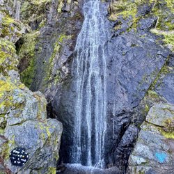
Beautiful 109ft waterfall off Ice House rd. The dirt road to the trailhead is bumpy and just before you reach the trailhead there are some gnarly potholes that I wouldn't recommend going over unless you have a high clearance vehicle. There are spots along the dirt road you can park & just walk the rest of the way to the trailhead. The hike itself is too easy not to do if you aren't a serious hiker and a lot of fun if you have kiddos. If you go during the summer it will likely be just a trickle. I try to go twice a year before end of May. Last 2 years I went as early as Feb & while the falls were lovely there wasn't any snow on the ground. I'd gladly wait until May to visit if it meant there was snow up there. Anyway from the trailhead walk until the trees clear out & you're walking over granite. You'll hear the falls before you see them. Plan a picnic there & enjoy the beauty that surrounds you. Late spring on wknds can be a little crowded so if you want that perfect selfie consider visiting at other times. read more


9 years ago
1st Family hiking trip. 2 miles one way.. worth the walk. Friendly people we met....will definitely be back. read more


12 years ago
14 years ago
What a nice hike. Went April 8, 2012, and the road to the parking lot was closed until April 16. But that was nice because it made the hike a bit longer than the short 1.2 mile jaunt. It was about 3 miles each way from the road. Easy hiking, easy to find. The falls were beautiful! Snow still on ground in places. I think during a particularly wet winter, the trail may have been closed, but during this mild winter we lucked out to be able to go so early. Highly recommend for a relaxing, shorter hike to an amazing area. Waterfall was a five star and you are surrounded by trickles and streams of water and wading pools. read more


9 years ago
Our first time coming. Loved the waterfalls and water, easy hike to the falls. I believe we did the second route, about 1mile to find it, Until.... we thought we were headed back in right direction and got so lost on the way back. We walked up the wrong pathways a couple times, climbing crazy uphill, we thought we had finally found it and it was a dead end, so we climbed through one small bush (thinking we can get on the right trail)we kept going deeper into the trees. 2 Moms, 2 kids, no experience hiking, we panicked lol finally after climbing through scary rocks, going thought trees, bushes and falling down large trees, we seen hikers across the way not too far. I yelled out to them to help lead us out. This sweet guy and his family, stomped down trees to get us back on the trail!! So thankful for this sweetheart! He carried my 6 year out out of sharp bushes, the rest of us got our legs cut up! Geez, we thought we'd never climb our way out! BEYOND THANKFUL TO THAT FAMILY, especially the sweetheart that stomped down trees and carried my little one to safety! So...If your newbies and not good with directions like I was, just stay on the trail that's easy to climb up, or your screwed!!lol Lesson learned! Overall beautiful to experience! Might be back with someone with more experience because now I don't trust myself!lol read more


11 years ago
I took my 4 year old son on this hike yesterday, and we truly enjoyed it! We didn't make it all the way to the top, but probably did a good 2 miles round trip. We made it to the bottom of the falls and hung out by the little pools. We followed the directions here on Yelp, and it took us about 90 minutes to get there from Sac. I recommend this hike for anyone with little kids! It was truly beautiful out there. read more

10 years ago
Great hike as it's not too challenging but still feels like hiking. The turnoff to the trail can be easy to miss and then there is a really long drive to the actual trail head. On the weekends in the summer the trail is really busy, so either go early or later. In late summer there probably won't be much water if any. read more


8 years ago
7 years ago
Amazing hike. However there are a few things to look out for that I wish I knew ahead of time to look out for , There is snow leftover on the trail so it was hard to navigate in some areas. Since there is snow melt, parts of the trail are covered in water and it would be good to wear waterproof shoes or your feet will get wet ! It wasn't too far to get to the fall but if you go off trail to see the smaller falls along the way , it's very worth it! To know where the trail actually is if you're going when there's still snow leftover , Stay on the areas that are open! There are a lot of spots that look like a trail and it's not. The parking lot is small so make sure to get there early. and I didn't happen to see any bathroom but maybe there was one near the campground but I'm not sure .Overall, the entire experience was great and the hike was easy aside from walking through some snow and water. The views are so beautiful and I would go there again. read more


9 years ago
13 years ago
8 years ago
Page 1 of 2
More info about Bassi Falls
El Dorado National Forest
Placerville, CA 95667
Directions
Hours
Outdoor Amenities
Ask the Community - Bassi Falls
Why does it say this is in placerville? It's not is it?
No, it is near Union Valley Reservoir off Ice House Road.
Is it stroller friendly ? We have a jogging stroller and a 17 month old I don't feel like carrying ?
actually, I think on most of the 1/2 mile trail a jogging stroller could be used. Closer to the falls, the trail becomes steep and rocky. tough call, I think you would need a 2nd person to help.
Kind of scared to come across snakes, be without reception or getting lost. Just curious if this is an easy enough hike for me & my 6 year old or any extra suggestions besides all these helpful reviews. Thanks in advance for any info?
Like Angela said, you will be just fine! You also have 3 hiking options. When you turn off of Ice House Road onto the gravel road you can keep driving straight which will lead you to the trailhead that's 2.5 miles to the falls. Or instead of going… Read more
Is it legal to camp down at the falls with a FS Permit?
There is a FS primitive camp on Silver Creek 2 miles downstream from the falls. Totally unimproved, sites right above the creek. But to your question, I'm pretty sure that you can camp anywhere you please with no fee, no permit. Search… Read more
Review Highlights - Bassi Falls


Why does Yelp recommend reviews?
1 review that is not currently recommended
The reviews below are not factored into the business's overall star rating.
16 years ago
Bassi Falls - hiking - Updated June 2026
Best of Placerville
People found Bassi Falls by searching for…
Swimming Holes in Placerville, California
Hiking Trails With Waterfalls in Placerville, California
Campgrounds in Placerville, California
Fishing in Placerville, California
Things to Do in Placerville, California
Parks in Placerville, California
Dog Friendly Hiking Trails in Placerville, California
Picnic Areas in Placerville, California
River Swimming in Placerville, California
Scenic Drive in Placerville, California
Dog Friendly Parks in Placerville, California
Free Snow Play in Placerville, California
Waterfalls in Placerville, California
Easy Hikes in Placerville, California
Natural Hot Springs in Placerville, California
Lookout Points in Placerville, California
Hiking With Kids in Placerville, California
Free Parking in Placerville, California
Dog Friendly Things to Do in Placerville, California
Beautiful Views in Placerville, California
Walking Trails in Placerville, California
Hikes With Dogs in Placerville, California
Trending Searches in Placerville, CA
Black Owned Nail Salons near Bassi Falls
Cliff Jumping near Bassi Falls
Dog Friendly Trails near Bassi Falls
Fishing Spots near Bassi Falls
Jet Ski Rental near Bassi Falls
Lakes & Ponds near Bassi Falls
Off Road Trails near Bassi Falls
Outdoor Activities near Bassi Falls
Places To Walk Around near Bassi Falls
Public Shower near Bassi Falls
River Swimming near Bassi Falls
Scenic Night View near Bassi Falls
Scenic Overlook near Bassi Falls
Secluded Spots near Bassi Falls
Strawberry Picking near Bassi Falls
Swimming Holes near Bassi Falls
Browse Brands
Related Searches in Placerville, CA
Affordable Kayak Rental Services in Placerville, California
Best Fishing Locations and Guides in Placerville, California
Best Nature Trails for Hiking in Placerville, California
Best Places for Horseback Riding in Placerville, California
Best Sledding Spots and Fun in Placerville, California
Best Waterfalls and Swimming Holes in Placerville, California
Check Out Off Road Trails in Placerville, California
Discover Dog Friendly Trails to Explore in Placerville, California
Discover Kid Friendly Hiking Trails in Placerville, California
Discover Scenic Waterfall Spots in Placerville, California
Discover Top Nature Parks to Visit in Placerville, California
Discover a Hiking Trail in Placerville, California
Discover the Best Night Hike Trails in Placerville, California
Discover the Best Running Track in Placerville, California
Dog-Friendly Hikes With Dogs in Placerville, California
Enjoy Camping Adventures Around Placerville, California
Enjoy Exciting Mountain Biking Adventures in Placerville, California
Enjoy Kayaking Adventures in Placerville, California
Enjoy a Beautiful Waterfall Hike in Placerville, California
Enjoy the Best Picnic Spots and Ideas in Placerville, California
Enjoy the Best Walking Trails in Placerville, California
Experience Thrilling White Water Rafting in Placerville, California
Explore Beautiful Parks and Green Spaces in Placerville, California
Explore Easy Hikes Perfect for All in Placerville, California
Explore Fun Activities to Do in Placerville, California
Explore Popular Campgrounds Near Placerville, California
Explore the Best Beach Spots in Placerville, California
Explore the Best Boating Spots in Placerville, California
Explore the Best Swimming Holes Around Placerville, California
Explore the Best Trail Options in Placerville, California
Family Friendly Hiking With Kids in Placerville, California
Find Beautiful Views in Placerville, California
Find Popular Ziplining Spots Around Placerville, California
Find the Best Parks for Picnics in Placerville, California
Find the Best Playgrounds to Visit in Placerville, California
Find the Best Scenic View Locations in Placerville, California
Great Places to Walk in Placerville, California
Hiking Trails With Waterfalls in Placerville, California
Off Leash Dog Hiking Trails in Placerville, California
Plan a Scenic Drive Route Near Placerville, California
Popular Outdoor Activities to Try in Placerville, California
Popular Picnic Spots to Visit in Placerville, California
Safe River Swimming Areas in Placerville, California
Safe and Fun Parks for Kids in Placerville, California
Top Climbing Spots and Gyms in Placerville, California
Top Running Trails to Explore in Placerville, California
Top Swimming Spots and Pools in Placerville, California
Top Things to Do With Kids in Placerville, California
Walk Dog Friendly Hiking Trails in Placerville, California
Walk the Best Paved Walking Trails in Placerville, California
Browse Articles
People who viewed Bassi Falls also viewed
Sly Park Recreation Area
199 reviews
Dutch Creek Trail
2 reviews
Wrights Lake
26 reviews
Winnemucca Lake
7 reviews
Horsetail Falls Hike
38 reviews
Yellow Jacket Camp Ground
9 reviews
Loon Lake Reservoir
18 reviews
Bridal Veil Falls
31 reviews
Bayview Trailhead-Bayview Campground
22 reviews
Icehouse Reservoir
7 reviews