El Dorado Trail Photos


You might also consider
More like El Dorado Trail
Recommended Reviews - El Dorado Trail
Start your review...

5 months ago


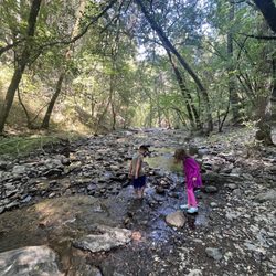
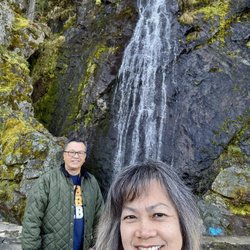
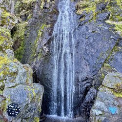
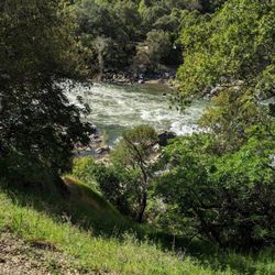
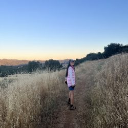
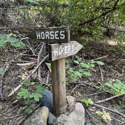
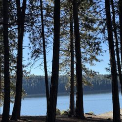
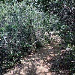
Do people get on your nerves? Do you ever feel drained of energy after spending time around people? LOL! Well perhaps you need some soul refreshment in nature, doing something physical, away from people. Look no further than the El Dorado Trail. And if you like the scent of forest, this is a great place to get it without having to drive fully into the Sierras. It's a 30 min/ 25 mile drive from Carmichael. There are 4-6 parking areas where you can hook onto the trail. I used 4451 Missouri Flat Rd, Placerville, (free, no time limit) and went east. Dont make me regret telling you this, but if you're lucky, you might get a glimpse of the Long-tailed Weasel in this general area. Google maps shows two port-a-potty units in the parking lot but they're gone. The one located about 1-3 miles east of downtown Placerville is still there. There's a public restroom on Main St in downtown Placerville. The path is mostly smooth but there's patches of lifted asphalt, so be careful. I used the trail as a bicyclist so my review is from that perspective. The route for a road bicycle is about 23 miles if you add Placerville Rd and Ray Lawyer (this "cat's claw" shape adds 3 miles and a good climb if you are turning left onto Ray Lawyer from Placerville Rd. The route starts out with a hint of downhill but then climbs steadily. Once you get to Halcon at the end of the paved route and you return on the same route, you'll be headed downhill. Be careful carrying speed, there's some inconsistencies with the pavement. And the two bridges that you cross are rustic styled and not smooth for a road bike. There's a third bridge, paved, that goes over El Dorado Freeway/50. The trail breaks up in a few places and you use the shoulder of the road to connect the sections of bike path. The trail is open to pedestrians, cyclists (non-motorized), and equestrians. There were very few trail users which I really liked. This is a good series of trails and if your tooling around downtown Placerville, it's a great way to walk off lunch! read more


More info about El Dorado Trail
Placerville, CA 95667
Directions
Hours
Outdoor Amenities


El Dorado Trail - hiking - Updated June 2026
Best of Placerville
People found El Dorado Trail by searching for…
Parks in Placerville, California
Things to Do in Placerville, California
Hiking Trails in Placerville, California
Walking Trails in Placerville, California
Things to Do at Night in Placerville, California
Natural Hot Springs in Placerville, California
View Points in Placerville, California
Off Road Trails in Placerville, California
Scenic View in Placerville, California
Bike Path in Placerville, California
Trails in Placerville, California
Mountain Biking in Placerville, California
Waterfalls in Placerville, California
Fall Foliage in Placerville, California
Beautiful Views in Placerville, California
Nature Walks in Placerville, California
Waterfalls and Swimming Holes in Placerville, California
Off Leash Dog Hikes in Placerville, California
Easy Hikes in Placerville, California
Running Trails in Placerville, California
Fun Things to Do With Kids in Placerville, California
Nature in Placerville, California
Trending Searches in Placerville, CA
Black Owned Nail Salons near El Dorado Trail
Boat Rental near El Dorado Trail
Cliff Jumping near El Dorado Trail
Day Trips near El Dorado Trail
Dog Friendly Trails near El Dorado Trail
Fireworks near El Dorado Trail
Fishing Spots near El Dorado Trail
Jet Ski Rental near El Dorado Trail
Kayak Rental near El Dorado Trail
Lakes & Ponds near El Dorado Trail
Outdoor Activities near El Dorado Trail
Places To Walk Around near El Dorado Trail
Public Pools near El Dorado Trail
Public Shower near El Dorado Trail
River Swimming near El Dorado Trail
Rock Quarry near El Dorado Trail
Scenic Night View near El Dorado Trail
Scenic Overlook near El Dorado Trail
Secluded Spots near El Dorado Trail
Soccer Store near El Dorado Trail
Splash Pad near El Dorado Trail
Strawberry Picking near El Dorado Trail
Sunrise View near El Dorado Trail
Swimming Holes near El Dorado Trail
Swimming Lakes near El Dorado Trail
Watch Sunset near El Dorado Trail
Browse Articles
Browse Nearby
BEST of Placerville, California Coffee near El Dorado Trail
BEST of Placerville, California Restaurants near El Dorado Trail
BEST of Placerville, California Things to Do near El Dorado Trail
BEST of Placerville, California Walking Trails near El Dorado Trail
BEST of Placerville, California Parks near El Dorado Trail
BEST of Placerville, California Breakfast near El Dorado Trail
BEST of Placerville, California Caves near El Dorado Trail
BEST of Placerville, California Hot Springs near El Dorado Trail
BEST of Placerville, California Campgrounds near El Dorado Trail
Browse Brands
Related Searches in Placerville, CA
Affordable Kayak Rental Services in Placerville, California
Best Fishing Locations and Guides in Placerville, California
Best Nature Trails for Hiking in Placerville, California
Best Places for Horseback Riding in Placerville, California
Best Sledding Spots and Fun in Placerville, California
Best Waterfalls and Swimming Holes in Placerville, California
Check Out Off Road Trails in Placerville, California
Discover Dog Friendly Trails to Explore in Placerville, California
Discover Kid Friendly Hiking Trails in Placerville, California
Discover Scenic Waterfall Spots in Placerville, California
Discover Top Nature Parks to Visit in Placerville, California
Discover a Hiking Trail in Placerville, California
Discover the Best Night Hike Trails in Placerville, California
Discover the Best Running Track in Placerville, California
Dog-Friendly Hikes With Dogs in Placerville, California
Enjoy Camping Adventures Around Placerville, California
Enjoy Exciting Mountain Biking Adventures in Placerville, California
Enjoy Kayaking Adventures in Placerville, California
Enjoy a Beautiful Waterfall Hike in Placerville, California
Enjoy the Best Picnic Spots and Ideas in Placerville, California
Enjoy the Best Walking Trails in Placerville, California
Experience Thrilling White Water Rafting in Placerville, California
Explore Beautiful Parks and Green Spaces in Placerville, California
Explore Easy Hikes Perfect for All in Placerville, California
Explore Fun Activities to Do in Placerville, California
Explore Popular Campgrounds Near Placerville, California
Explore the Best Beach Spots in Placerville, California
Explore the Best Boating Spots in Placerville, California
Explore the Best Swimming Holes Around Placerville, California
Explore the Best Trail Options in Placerville, California
Family Friendly Hiking With Kids in Placerville, California
Find Beautiful Views in Placerville, California
Find Popular Ziplining Spots Around Placerville, California
Find the Best Parks for Picnics in Placerville, California
Find the Best Playgrounds to Visit in Placerville, California
Find the Best Scenic View Locations in Placerville, California
Great Places to Walk in Placerville, California
Hiking Trails With Waterfalls in Placerville, California
Off Leash Dog Hiking Trails in Placerville, California
Plan a Scenic Drive Route Near Placerville, California
Popular Outdoor Activities to Try in Placerville, California
Popular Picnic Spots to Visit in Placerville, California
Safe River Swimming Areas in Placerville, California
Safe and Fun Parks for Kids in Placerville, California
Top Climbing Spots and Gyms in Placerville, California
Top Running Trails to Explore in Placerville, California
Top Swimming Spots and Pools in Placerville, California
Top Things to Do With Kids in Placerville, California
Walk Dog Friendly Hiking Trails in Placerville, California
Walk the Best Paved Walking Trails in Placerville, California