Johnny Cash Trail Photos
 - Landmarks & Historical Buildings Near Me - Folsom, California")


You might also consider
More like Johnny Cash Trail
Recommended Reviews - Johnny Cash Trail
Start your review...

Reviews With Photos

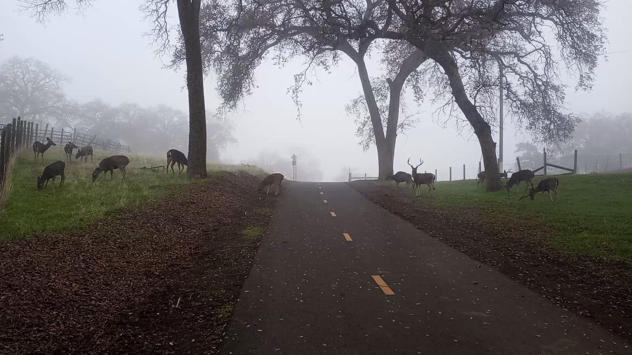
Finding the trail is a little confusing but if you park in the library lot its pretty much a few hundred yards down the hill through another parking lot. Once there you can go left to see the bridge and eventually get to Folsom Prison. Along the way you will likely see squirrels, turkeys and lots of deer. If you take the trail to the right you will be in old town within ten to fifteen minutes. We went left to the prison returned to our starting point and then went right to hsve brunch in Folsom. The trail is a great way to get some exercise and wind up in old town for a drink and a bite.

Love this part of the bike course that takes you along the beautiful American River Bike trail. My cycling group and I would also meeting up early on a Saturday morning near Howe/Hwy 50. And enter the bike trail for a minimum 20 mile ride along side the river, where we'd go typically out to Nimbus Point and back. If we were wanting to get in say a 50 mile ride, then we would make our way to or start in Folsom. And we'd be sure to rider up and through Johnny Cash Trail. I love seeing the different scenery from along the way, and enjoy the different degrees of terrain while out on the trail. Depending on what part of the trail you're on, expect to see various groups out her from dog walkers, to avid runners to cyclists. I've never had issues with any of groups while out here (both cyclists or those on foot). But I know and have heard stories from both sides. As someone who comes out to ride, depending on route, we can be traveling at speeds of 20 to up to 30+ miles an hr in many cases. And trail walkers many times can move out into your path in the blink of an eye. Which is extremely dangerous for all involved. So cyclists are constantly looking out for obstacles on the trail, while others on a slower path may not realize how fast cyclist can appear.

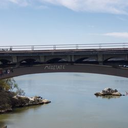
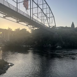
We failed miserably at walking to the Johnny Cash Bridge. Given the art installations aren't all yet complete, trail signs are also lacking. The walking path is considered complete. Google Maps seems a better resource than the official trail website: https://folsomcasharttrail.com/Portals/0/Documents/JCT_Trail_Map_072519.pdf Trail is about 2.5 miles long, 2.75 miles according to one website. Only the two bridges are complete. For parking and directions to the trail, I referred to the detailed Yelp review by Stephanie S. Thank you, Stephanie! To find her review, you could search on "Folsom Zoo" or "Robbers Bridge", which are where you should park and the first sight you'll see. Main thing to know is to head towards the back of the City Hall/Folsom Zoo parking lot, stay left, and look for stairs down to the trail. It is not easy or obvious to find this trail entrance. https://www.yelp.com/biz/johnny-cash-trail-folsom?hrid=6Hh3LPBDCY3HB2tNOGlyYQ&utm_campaign=www_review_share_popup&utm_medium=copy_link&utm_source=(direct) We saw the Robbers' Ravine Bridge and then lots of signs for the state prison and future art installations. We didn't know the best route to Johnny Cash Bridge after hitting the intersection with a tree-lined trail to Folsom Prison on our left, a curving bike trail under a white bridge to our right, and a path leading up to the bridge on trafficky Natoma St. Of the 3 paths on a hot day, the shady path looked the most inviting and at least had a brown sign mentioning Folsom State Prison, but it was not correct. If you go up onto Natoma Street and stay on the closest side, going right leads you back to where you parked, but you can't go left! The sidewalk ends with a construction sign (hyphen in a circle). Perhaps the sidewalk is on the opposite side of busy Natoma Street? I didn't see a nearby crosswalk, so maybe you need to walk to the nearest intersection? I think you're supposed to go left on East Natoma Street somehow. No "Amazing Race" for me! The clear scenic route would be to follow the underpass bike route, which is what this website suggests doing: https://www.americantrails.org/resources/new-trail-honors-johnny-cash Here's the excerpt: "Visitors on the newer segment of the trail enter an underpass beneath the main prison road to avoid disrupting deliveries and other vehicle traffic. Farther along the trail, is the Johnny Cash Bridge..." My friend said that would be a longer route than Natoma Street, so she didn't want to go. Not many people are on this trail on a weekday afternoon, so my friend didn't feel comfortable exploring and getting lost around here. It's mostly people exercising. Not a whole lot to see yet. I wish there were anticipated dates for each art installation, but fundraising and art creation are still happening. Afterwards, I looked at Google Maps to search for an easier way to walk to Johnny Cash Bridge or Johnny Cash Trail Overcrossing (which is what Google Maps calls it). Folsom Point State Park appears to have two parking lots near it. I haven't tried parking there yet, but maybe a local in Folsom or a more ambitious tourist/walker can verify for me? Parking Lot 1 near Johnny Cash Trail Overcrossing https://goo.gl/maps/Q5iy1fNwVhu4J2uw6 Parking Lot 1 near Johnny Cash Trail Overcrossing https://goo.gl/maps/QQpxXZVhtwdn32Ns9 As Yelp reviewer Shirley M.J. suggested, we ended up driving by Johnny Cash Bridge to photograph it. Because I was the passenger, I was able to take motion photos as we approached it. https://www.yelp.com/biz/johnny-cash-trail-folsom?hrid=TFw_Sm_DlREBkTxwCL8lVA&utm_campaign=www_review_share_popup&utm_medium=copy_link&utm_source=(direct) Here are some videos about the future art installations, most of which will be created by Adan Romo of Romo Studios: https://vimeo.com/236156304 http://romostudios.com/Projects/Johnny-Cash-Trail Also planned for the future will be the Man in Black statue in the future Legacy Park. The Man in Black statue will be designed by Gary Tillery of Fine Art Studio of Rotblatt Amrany. Legacy Park will be a collaborative design by RRM Design Group and Rotblatt Amrany Studio: https://rotblattamrany.com/man-black-landmark/ https://folsomcasharttrail.com/artwork/meet-the-artists/rotblatt-amrany About the Johnny Cash Trail - Click VIEW MASTER PLAN: https://folsomcasharttrail.com/the-trail/about

We really enjoy this trail. It is completely paved and is a great walk all year long. The hike is very easy if you have kids or are not looking for a challenging trail this is your spot. You walk right along the prison towards the end of the trail. There is a cool bridge and lots of available parking.

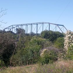
One reviewer asked, "Is the trail a loop?" The answer is technically no, but it's easy to make one, and I will explain how. The Johnny Cash Trail begins on a self-named bridge over Lake Natoma Crossing, near the intersection with East Natoma Street, at what used to be a terminus of the American River Bike Trail. It ends when it meets the trail leading over the Truss Bridge, which is part of the American River Bike Trail. Notice how it begins and ends at the American River Bike Trail? Therefore, it is possible to make a loop around the river in either direction by simply connecting the trails. As long as you stay on a main trail in Folsom and keep the river on the same side of you as it was when you started, you probably won't get lost. You can even do a loop that goes all the way around both dams (Folsom and Nimbus) by including the Lake Natoma Bike Trail. One reviewer said, "Watch out for speedy bicyclists!" As an avid hiker and cyclist, I would just like to point out that the easiest way to stay safe on the trail is to simply follow directions. Make sure that you are facing bike traffic, be aware of the fact that it is perfectly legal for them to fly by you at what may feel like a fast speed to you, and be glad that they're doing it here instead of on a main road, which would be more dangerous for everyone. One reviewer said, "I just feel it was frustrating that the trail keeps changing sides of where you can walk." This was a misunderstanding on her part. In Folsom, pedestrians should always walk facing bike traffic. If a bicyclist is truly flying right by you and/or yelling at you, chances are that you are on the wrong side of the road. I agree that signage could be more clear on the Truss Bridge (technically not part of this trail, but close), where, for some reason, pedestrians almost always break the rules by walking on the wrong side, causing safety concerns for cyclists. (I can't tell you the number of times I've been yelled at by a pedestrian for "speeding on the bike trail," which I am practically physically incapable of doing. I clock around 13 miles an hour at best, and the speed limit is 15.) That being said, there are a few cyclists out there who ride in an unsafe manner. If you want to be sure to avoid them, or want a more family-friendly experience, I would recommend the river-front near Sutter Street, or Powerhouse Park, or the Willow Creek Trail. One reviewer said: "You get great views of the prison, hence the name Johnny Cash Trail." True. I would argue that the best views of the prison overall are from the Jedediah Smith hiking trail, but on a good day, you can actually walk right up to Folsom Prison from the Johnny Cash Trail! This is done via an auxiliary trail near the terminus of the Oak Avenue Parkway Trail. Sometimes it's locked, but it's usually open in good weather, when the cows are in town. As other reviewers have pointed out, there is only like, one art installation so far. According to signs on the trail, the rest are still waiting for funding. With all of that in mind, this is currently the best-maintained trail in Folsom. Like any other trail in Folsom, you can expect to see deer, coyote, turkeys, snakes, lizards, bunnies, hawks, eagles, herons, bobcats, etc. Depending on the season, there will usually be an abundance of mushrooms and/or wildflowers.

Paved 2-way trail. Be careful if you stop to take pictures or cross the path because bike riders are constantly flying past you. Apparently the signage can be good depending on where you hop on the trail, but I was a bit puzzled where the trail started and stopped near the Folsom Powerhouse. Does it cross the rainbow bridge? Is it a loop? Is the Jebediah Smith Memorial Trail part of the loop? Either way, I very much enjoyed the scenery and serenity (when you're not near roads).


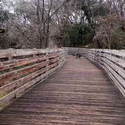
I love getting out in nature and today I took a walk on the Johnny Cash Trail in Folsom, Ca. With my husband on our wedding anniversary. To commemorate our special day, we left a hand painted rock on the path. Though the weather was very hot and we didn't go as far as I would have liked, I knew it was a place I wanted to return to in the future to take in beautiful views and just unwind. The trail has some gorgeous pedestrian bridges on it and I enjoyed the references to Johnny Cash along the way. I recommend walking and hiking along the trail especially because of its close proximity to the historic section of the town which has some good restaurants to dine at after getting your exercise.

This trail is fantastic, however watch out for speedy bicycles watch the markings as to which side you to be walking on or plan on a good time with angry bicyclists. RUDE. Anyways paths are great. Disappointed no Art that we thought was going to be there. Rolling hills will be beautiful in the spring Walk to old Folsom had some good up down works the heart but not so strenuous.

My brother and I decided to go walk around and check out downtown Folsom. The trail has entry points close to downtown. This is a great place to go for a walk, run, bike, scooter possibly a horse back ride. This is a great site seeing trail. You get glimpses of Folsom prison hence the name Jonny cash trail. This trail is for all levels of endurance and is fairly gentle. I believe there are even trails down to the river to fish or take you or your dogs for a swim. There are bathrooms on part of the trail and some drinking fountains. If you get hungry or want a drink just head back up to downtown and enjoy the local restaurants and tap rooms. You could definitely make a day out of Folsom and the Jonny cash trail.

4/10/2019: Alrighty, Folks~NO CHEATING! You literally can't stop anywhere taking a snapshot of Johnny Cash Trail's tower bridge-PERIOD! You must literally do a slow drive by or hoof over a quarter to a full mile in order, taking the two photos I took from my brother, Albert's car whizzing by! Seriously: There are a PLETHORA of "NO STOPPING" and "DO NOT PARK" signs along the Natomas Parkway! So, please don't stop or park anywhere! Anyway, in 2016, I began camping at Beal's Point Campground: The entire Folsom Dam along Natomas Parkway was undergoing heavy-around-the-clock construction adding two more dams. Camping seven days' stay was utterly grueling hearing the jackhammers pounding all night caused severe insomnia! By morning, I'd roust myself out of my cot, slipping outside of my tent crawling out on my hands and knees with the proverbial, unsightly bedhead, being blind-sighted by the morning sun, grabbing my coffee cup in hand, and proceeded hiking Johnny Cash Trail: Please keep in mind, I found myself dodging heavy-duty diggers and massive construction vehicles on location, i.e., egregiously precarious! Fast forwarding to April 10, 2019, the entire Natomas Parkway is easy traversing NOW AND peacefully quiet than when I was insane in the brain hiking during the 2016 massive construction! OOOOOooof!

It was a beautiful morning for our hike yesterday! My friend and I got up before the crack of dawn to take on this trail and get our steps in for the day. The trail is about 6 miles total, 3 miles in and 3 miles back. It wasn't difficult at all, there were some hilly parts, but nothing too drastic. Along the way we saw some wild turkeys and some deer, it was the highlight of our walk! The trail was paved for easy walking, biking, and even running. Please make sure you pay attention as there were signs painted on the ground letting you know which path is for cyclist and pedestrian. It changes throughout the trail, so you don't get mowed down by a cyclist. We've enjoyed this trail and had a really good time! I would recommend this trail to anyone looking to see some nice views and just plain enjoy being out in nature!

This new section of the trail is great! It is beautifully paved and there are lots of signs indicating that it is the Johnny Cash trail. The art installations are not complete, but there are signs indicating where they will be eventually. The scenery is beautiful, and heading north one gets a great hill workout. The meadowy areas that are marked prison property are gorgeous and the signs are scary enough to convey that for reals, don't jump the fence and trespass. Why only four stars? Because I can never understand on Folsom paved bike trails what the rules are for which side of the trail pedestrians and cyclists are supposed to be on. I swear, in all other places I have lived or visited, both cyclists and pedestrians stay on the far right side. Runners stay on the very far right, and cyclists pass on the left. I understand that this is NOT the way it is done here. Pedestrians and runners appear to stay on the left, which makes absolutely no sense to me. The trail is so new that the painted markings that communicate this nonsense have not been added. Sidenote: I have zero clue why people care so much about Johnny Cash. When I moved to Reno, so many of my acquaintances were like "shot a man in Reno, just to watch him die" to me. Okay... I have since come to realize that Social Distortion's cover of "Ring of Fire" is a decent song to hear once every two months. But it makes me angry whenever people think "Hurt" is a Cash original and NOT a cover of Nine Inch Nails! But if Folsom folks love Cash, more power to them!

2 months ago
Shoutout to Folsom, CA! Johnny Cash Trail. So you may be wondering... "what is the Johnny Cash Trail?". It's 2.75 miles of a class I paved bike and walking trail that is not a loop. It goes from Historic Folsom to the Folsom Lake Crossing Trail. Why is the trail named after Johnny Cash? Well he wrote and recorded the song "Folsom Prison Blues" in 1952. Yup, he was singing about the prison that the trail runs nearby. No, you can't see the prison yard. So don't think about planning any jail breaks. Anyways, I didn't start my walk at either the two end points. I started behind the Dan Russell rodeo arena which is behind the library parking lot. The arena has a parking lot as well with both free to park. I headed west towards Historic Folsom. There are marked trail signs. This section has a gradual decline/incline which may prove challenging for folks with mobility issues. The trail opens onto the sidewalk on Riley Street, look for Johnny Cash's guitar pick art sculpture. It's a 7 foot tall black bronze sculpture designed by local artist Adan Romo. A guitar pick is at both the beginning and end of the trail. The trail is shared by pedestrians and cyclists, so for goodness sakes follow the instructions on which side of the path you should be on. Plus please be especially vigilant on those hairpin turns and keep an eye on your kiddos and leashed pets. Thank you City of Folsom for creating and maintaining the trail, and adding more art installations. read more


It was one of those perfect California days where the weather does half the work for you. I finally took on the full 6.6 miles of the Johnny Cash Trail -- and after living here so long, I'm kicking myself for not doing it sooner. The trail is clean, wide, and full of those quiet moments that make you slow down without even trying. The views hit you from every angle...the rolling foothills, the long stretches of open trail, and those iconic art installations that remind you why this place carries the name it does. Met some cool people along the way too -- the kind of trail conversations that make the miles feel lighter and the day feel brighter. Nothing forced, just good energy and easy connection. In all, it wasn't a bad walk at all... actually, it was the kind of hike that resets you. A little sweat, a little sunshine, a little unexpected community -- the perfect reminder of why Northern California always pulls me back in. read more


11 days ago
2 months ago
2 years ago
Finding the trail is a little confusing but if you park in the library lot its pretty much a few hundred yards down the hill through another parking lot. Once there you can go left to see the bridge and eventually get to Folsom Prison. Along the way you will likely see squirrels, turkeys and lots of deer. If you take the trail to the right you will be in old town within ten to fifteen minutes. We went left to the prison returned to our starting point and then went right to hsve brunch in Folsom. The trail is a great way to get some exercise and wind up in old town for a drink and a bite. read more


1 year ago
Love this part of the bike course that takes you along the beautiful American River Bike trail. My cycling group and I would also meeting up early on a Saturday morning near Howe/Hwy 50. And enter the bike trail for a minimum 20 mile ride along side the river, where we'd go typically out to Nimbus Point and back. If we were wanting to get in say a 50 mile ride, then we would make our way to or start in Folsom. And we'd be sure to rider up and through Johnny Cash Trail. I love seeing the different scenery from along the way, and enjoy the different degrees of terrain while out on the trail. Depending on what part of the trail you're on, expect to see various groups out her from dog walkers, to avid runners to cyclists. I've never had issues with any of groups while out here (both cyclists or those on foot). But I know and have heard stories from both sides. As someone who comes out to ride, depending on route, we can be traveling at speeds of 20 to up to 30+ miles an hr in many cases. And trail walkers many times can move out into your path in the blink of an eye. Which is extremely dangerous for all involved. So cyclists are constantly looking out for obstacles on the trail, while others on a slower path may not realize how fast cyclist can appear. read more

3 years ago
We failed miserably at walking to the Johnny Cash Bridge. Given the art installations aren't all yet complete, trail signs are also lacking. The walking path is considered complete. Google Maps seems a better resource than the official trail website: https://folsomcasharttrail.com/Portals/0/Documents/JCT_Trail_Map_072519.pdf Trail is about 2.5 miles long, 2.75 miles according to one website. Only the two bridges are complete. For parking and directions to the trail, I referred to the detailed Yelp review by Stephanie S. Thank you, Stephanie! To find her review, you could search on "Folsom Zoo" or "Robbers Bridge", which are where you should park and the first sight you'll see. Main thing to know is to head towards the back of the City Hall/Folsom Zoo parking lot, stay left, and look for stairs down to the trail. It is not easy or obvious to find this trail entrance. https://www.yelp.com/biz/johnny-cash-trail-folsom?hrid=6Hh3LPBDCY3HB2tNOGlyYQ&utm_campaign=www_review_share_popup&utm_medium=copy_link&utm_source=(direct) We saw the Robbers' Ravine Bridge and then lots of signs for the state prison and future art installations. We didn't know the best route to Johnny Cash Bridge after hitting the intersection with a tree-lined trail to Folsom Prison on our left, a curving bike trail under a white bridge to our right, and a path leading up to the bridge on trafficky Natoma St. Of the 3 paths on a hot day, the shady path looked the most inviting and at least had a brown sign mentioning Folsom State Prison, but it was not correct. If you go up onto Natoma Street and stay on the closest side, going right leads you back to where you parked, but you can't go left! The sidewalk ends with a construction sign (hyphen in a circle). Perhaps the sidewalk is on the opposite side of busy Natoma Street? I didn't see a nearby crosswalk, so maybe you need to walk to the nearest intersection? I think you're supposed to go left on East Natoma Street somehow. No "Amazing Race" for me! The clear scenic route would be to follow the underpass bike route, which is what this website suggests doing: https://www.americantrails.org/resources/new-trail-honors-johnny-cash Here's the excerpt: "Visitors on the newer segment of the trail enter an underpass beneath the main prison road to avoid disrupting deliveries and other vehicle traffic. Farther along the trail, is the Johnny Cash Bridge..." My friend said that would be a longer route than Natoma Street, so she didn't want to go. Not many people are on this trail on a weekday afternoon, so my friend didn't feel comfortable exploring and getting lost around here. It's mostly people exercising. Not a whole lot to see yet. I wish there were anticipated dates for each art installation, but fundraising and art creation are still happening. Afterwards, I looked at Google Maps to search for an easier way to walk to Johnny Cash Bridge or Johnny Cash Trail Overcrossing (which is what Google Maps calls it). Folsom Point State Park appears to have two parking lots near it. I haven't tried parking there yet, but maybe a local in Folsom or a more ambitious tourist/walker can verify for me? Parking Lot 1 near Johnny Cash Trail Overcrossing https://goo.gl/maps/Q5iy1fNwVhu4J2uw6 Parking Lot 1 near Johnny Cash Trail Overcrossing https://goo.gl/maps/QQpxXZVhtwdn32Ns9 As Yelp reviewer Shirley M.J. suggested, we ended up driving by Johnny Cash Bridge to photograph it. Because I was the passenger, I was able to take motion photos as we approached it. https://www.yelp.com/biz/johnny-cash-trail-folsom?hrid=TFw_Sm_DlREBkTxwCL8lVA&utm_campaign=www_review_share_popup&utm_medium=copy_link&utm_source=(direct) Here are some videos about the future art installations, most of which will be created by Adan Romo of Romo Studios: https://vimeo.com/236156304 http://romostudios.com/Projects/Johnny-Cash-Trail Also planned for the future will be the Man in Black statue in the future Legacy Park. The Man in Black statue will be designed by Gary Tillery of Fine Art Studio of Rotblatt Amrany. Legacy Park will be a collaborative design by RRM Design Group and Rotblatt Amrany Studio: https://rotblattamrany.com/man-black-landmark/ https://folsomcasharttrail.com/artwork/meet-the-artists/rotblatt-amrany About the Johnny Cash Trail - Click VIEW MASTER PLAN: https://folsomcasharttrail.com/the-trail/about read more


 on the Johnny Cash Trail - Landmarks & Historical Buildings Near Me - Folsom, California")

 on the Johnny Cash Trail - Landmarks & Historical Buildings Near Me - Folsom, California")
We really enjoy this trail. It is completely paved and is a great walk all year long. The hike is very easy if you have kids or are not looking for a challenging trail this is your spot. You walk right along the prison towards the end of the trail. There is a cool bridge and lots of available parking. read more


4 years ago
One reviewer asked, "Is the trail a loop?" The answer is technically no, but it's easy to make one, and I will explain how. The Johnny Cash Trail begins on a self-named bridge over Lake Natoma Crossing, near the intersection with East Natoma Street, at what used to be a terminus of the American River Bike Trail. It ends when it meets the trail leading over the Truss Bridge, which is part of the American River Bike Trail. Notice how it begins and ends at the American River Bike Trail? Therefore, it is possible to make a loop around the river in either direction by simply connecting the trails. As long as you stay on a main trail in Folsom and keep the river on the same side of you as it was when you started, you probably won't get lost. You can even do a loop that goes all the way around both dams (Folsom and Nimbus) by including the Lake Natoma Bike Trail. One reviewer said, "Watch out for speedy bicyclists!" As an avid hiker and cyclist, I would just like to point out that the easiest way to stay safe on the trail is to simply follow directions. Make sure that you are facing bike traffic, be aware of the fact that it is perfectly legal for them to fly by you at what may feel like a fast speed to you, and be glad that they're doing it here instead of on a main road, which would be more dangerous for everyone. One reviewer said, "I just feel it was frustrating that the trail keeps changing sides of where you can walk." This was a misunderstanding on her part. In Folsom, pedestrians should always walk facing bike traffic. If a bicyclist is truly flying right by you and/or yelling at you, chances are that you are on the wrong side of the road. I agree that signage could be more clear on the Truss Bridge (technically not part of this trail, but close), where, for some reason, pedestrians almost always break the rules by walking on the wrong side, causing safety concerns for cyclists. (I can't tell you the number of times I've been yelled at by a pedestrian for "speeding on the bike trail," which I am practically physically incapable of doing. I clock around 13 miles an hour at best, and the speed limit is 15.) That being said, there are a few cyclists out there who ride in an unsafe manner. If you want to be sure to avoid them, or want a more family-friendly experience, I would recommend the river-front near Sutter Street, or Powerhouse Park, or the Willow Creek Trail. One reviewer said: "You get great views of the prison, hence the name Johnny Cash Trail." True. I would argue that the best views of the prison overall are from the Jedediah Smith hiking trail, but on a good day, you can actually walk right up to Folsom Prison from the Johnny Cash Trail! This is done via an auxiliary trail near the terminus of the Oak Avenue Parkway Trail. Sometimes it's locked, but it's usually open in good weather, when the cows are in town. As other reviewers have pointed out, there is only like, one art installation so far. According to signs on the trail, the rest are still waiting for funding. With all of that in mind, this is currently the best-maintained trail in Folsom. Like any other trail in Folsom, you can expect to see deer, coyote, turkeys, snakes, lizards, bunnies, hawks, eagles, herons, bobcats, etc. Depending on the season, there will usually be an abundance of mushrooms and/or wildflowers. read more


Paved 2-way trail. Be careful if you stop to take pictures or cross the path because bike riders are constantly flying past you. Apparently the signage can be good depending on where you hop on the trail, but I was a bit puzzled where the trail started and stopped near the Folsom Powerhouse. Does it cross the rainbow bridge? Is it a loop? Is the Jebediah Smith Memorial Trail part of the loop? Either way, I very much enjoyed the scenery and serenity (when you're not near roads). read more


Busy trail! Watch out for the bikes! Watch out for walkers! It's a paved 2 way trail that starts at the prison. Goes through open fields, houses and parks. Didn't see water fountains or restrooms on the trail. Veer off to the parks for that. This trail favors bike riders. read more

I love getting out in nature and today I took a walk on the Johnny Cash Trail in Folsom, Ca. With my husband on our wedding anniversary. To commemorate our special day, we left a hand painted rock on the path. Though the weather was very hot and we didn't go as far as I would have liked, I knew it was a place I wanted to return to in the future to take in beautiful views and just unwind. The trail has some gorgeous pedestrian bridges on it and I enjoyed the references to Johnny Cash along the way. I recommend walking and hiking along the trail especially because of its close proximity to the historic section of the town which has some good restaurants to dine at after getting your exercise. read more


4 years ago
This trail is fantastic, however watch out for speedy bicycles watch the markings as to which side you to be walking on or plan on a good time with angry bicyclists. RUDE. Anyways paths are great. Disappointed no Art that we thought was going to be there. Rolling hills will be beautiful in the spring Walk to old Folsom had some good up down works the heart but not so strenuous. read more


My brother and I decided to go walk around and check out downtown Folsom. The trail has entry points close to downtown. This is a great place to go for a walk, run, bike, scooter possibly a horse back ride. This is a great site seeing trail. You get glimpses of Folsom prison hence the name Jonny cash trail. This trail is for all levels of endurance and is fairly gentle. I believe there are even trails down to the river to fish or take you or your dogs for a swim. There are bathrooms on part of the trail and some drinking fountains. If you get hungry or want a drink just head back up to downtown and enjoy the local restaurants and tap rooms. You could definitely make a day out of Folsom and the Jonny cash trail. read more


7 years ago
4/10/2019: Alrighty, Folks~NO CHEATING! You literally can't stop anywhere taking a snapshot of Johnny Cash Trail's tower bridge-PERIOD! You must literally do a slow drive by or hoof over a quarter to a full mile in order, taking the two photos I took from my brother, Albert's car whizzing by! Seriously: There are a PLETHORA of "NO STOPPING" and "DO NOT PARK" signs along the Natomas Parkway! So, please don't stop or park anywhere! Anyway, in 2016, I began camping at Beal's Point Campground: The entire Folsom Dam along Natomas Parkway was undergoing heavy-around-the-clock construction adding two more dams. Camping seven days' stay was utterly grueling hearing the jackhammers pounding all night caused severe insomnia! By morning, I'd roust myself out of my cot, slipping outside of my tent crawling out on my hands and knees with the proverbial, unsightly bedhead, being blind-sighted by the morning sun, grabbing my coffee cup in hand, and proceeded hiking Johnny Cash Trail: Please keep in mind, I found myself dodging heavy-duty diggers and massive construction vehicles on location, i.e., egregiously precarious! Fast forwarding to April 10, 2019, the entire Natomas Parkway is easy traversing NOW AND peacefully quiet than when I was insane in the brain hiking during the 2016 massive construction! OOOOOooof! read more


It was a beautiful morning for our hike yesterday! My friend and I got up before the crack of dawn to take on this trail and get our steps in for the day. The trail is about 6 miles total, 3 miles in and 3 miles back. It wasn't difficult at all, there were some hilly parts, but nothing too drastic. Along the way we saw some wild turkeys and some deer, it was the highlight of our walk! The trail was paved for easy walking, biking, and even running. Please make sure you pay attention as there were signs painted on the ground letting you know which path is for cyclist and pedestrian. It changes throughout the trail, so you don't get mowed down by a cyclist. We've enjoyed this trail and had a really good time! I would recommend this trail to anyone looking to see some nice views and just plain enjoy being out in nature! read more


9 years ago
This new section of the trail is great! It is beautifully paved and there are lots of signs indicating that it is the Johnny Cash trail. The art installations are not complete, but there are signs indicating where they will be eventually. The scenery is beautiful, and heading north one gets a great hill workout. The meadowy areas that are marked prison property are gorgeous and the signs are scary enough to convey that for reals, don't jump the fence and trespass. Why only four stars? Because I can never understand on Folsom paved bike trails what the rules are for which side of the trail pedestrians and cyclists are supposed to be on. I swear, in all other places I have lived or visited, both cyclists and pedestrians stay on the far right side. Runners stay on the very far right, and cyclists pass on the left. I understand that this is NOT the way it is done here. Pedestrians and runners appear to stay on the left, which makes absolutely no sense to me. The trail is so new that the painted markings that communicate this nonsense have not been added. Sidenote: I have zero clue why people care so much about Johnny Cash. When I moved to Reno, so many of my acquaintances were like "shot a man in Reno, just to watch him die" to me. Okay... I have since come to realize that Social Distortion's cover of "Ring of Fire" is a decent song to hear once every two months. But it makes me angry whenever people think "Hurt" is a Cash original and NOT a cover of Nine Inch Nails! But if Folsom folks love Cash, more power to them! read more

9 years ago
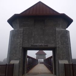
Johnny Cash / Folsom Prison Blues Trail was formerly known as part of the "Folsom Lake Trail". It was renamed to honor and to celebrate the legendary " Johnny Cash," himself, his music, and his history with the City of Folsom. The first phase of the trail is complete, being ( the bike, pedestrian bridge crossing at Folsom Lake Crossing. This bridge crossing was designed to resemble" Gothic "guard towers of Folsom State Prison's "West"gate. The trail does have a few minor hills but the majority of the trail is flat. The trail follows the Western edge of the Folsom State Prison easement . Once crossing the bridge, you'll find yourself walking /riding along Folsom Lake toward the dam. The trail has no shade, so bring plenty of water and wear a hat. The second and third phases of the trail are currently being constructed. The entire Johnny Cash/Folsom Prison Blues Trail is expected to be completed some time in 2018. When completed, there will be a 2 acre "Johnny Cash Legacy Park" and a series of art installations along the trail. The eight larger than life public art pieces will tell the story of Johnny Cash and his connection with the City of Folsom ! Once the trail is completed in 2018, The City of Folsom and the Johnny Cash/ Folsom Prison Blues Trail will be known world wide ! Can't wait for its completion! Will return to up-date my review. Enjoy ! read more


6 years ago
Sorry to say that this was one of my least favorite trail. The trail was well maintained. Although, there was a fork towards the middle of the trail that had us lost. There were no signs that said to keep straight or turn. So, we ended up towards the prison gates. There were grouchy old pedestrians along the trails. Definitely did not like the fact that it is along side the road where cars are polluting while we're on the trail. read more


2 years ago
5 years ago
Nice paved 2 way easy trail. The trail starts by Folsom prison and goes along fields and the city of Folsom. Don't expect to see views. The trail is good for walking, running or biking. I didnt see any bathrooms along or close to the trail. read more


7 years ago
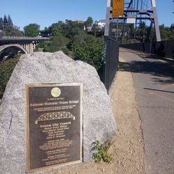
This is a review for all the people like me that could not find a CLEAR map or directions about how to get to this trail. My aimless walking has become your gain: The best way to get here is to park in the Folsom Zoo Parking lot and walk past the play structures (stick to the left). Once you pass the play structures, you'll go down a short dirt path that leads to a little set of stairs. After you go down the stairs, make a right and TA-DAH! you're on the Johnny Cash trail. The first landmark on the trail is "Robbers Bridge" which has a nice plaque explaining some history. Then right at the end of the trail theres the "Johnny Cash Bridge" decked out with American flags #Murica! Other than that, theres a lot of signs along the way that say "Future Site of Art Piece" but no clear maps or directories that indicate how far you've gone or how much further there is to go before the end of the trail. BUT FEAR NOT, (because I totally did) ALL GOOD THINGS COME TO AN END. The hike (aka leisurely stroll) is 5 miles round trip and has some slight uphill but you're on a paved path the whole time. We walked and it took us about 45 minutes to get to Folsom Lake (which is a nice spot to high five, stretch, then turn back around). Can't wait for the intended art pieces to go up! For now, there's a lovely view of happy cows and bikers galore. read more


8 years ago
Great trail, super fun to bike on, walk on, and even take great pics of the cows along the way! The biking path is superb, smooth, and connects with tons of other bike routes all along the American River Parkway. read more


7/4/19 - 7/4/19 - good six mile hike on the Johnny Cash Trail in Folsom. The freeway part of the trail was loud with no views, but the riverside and hillside was nice. There's not a whole lot of shade, so I would recommend going really early and bring water. There are no restrooms, so make sure you use the restroom first. It gets pretty busy, lots of bikers, kids on scooters/bikes and walkers. read more


4 years ago
9 years ago
9 years ago
Really nice bike trail that connects to a return bike trail after you cross the American River in front of Folsom Dam. read more

6 years ago
9 years ago
This trail is great for bicycles. I waked for a couple miles, but would have preferred touring it on bicycle to experience the entire trail. read more


7 years ago
7 years ago
More info about Johnny Cash Trail
Ask the Community - Johnny Cash Trail
Do we need our poles?
September 29, 2025 Poles? I not think so, trail is short not too steep. We had in our party six… Read more
February 6, 2025 What variety of Tourist Area is this place? I seeing it says Johnny (Ray) Cash…
February 6, 2025 Thinking is a touristy area, is there Admission Fee?
Review Highlights - Johnny Cash Trail
You might also consider


Johnny Cash Trail - landmarks - Updated May 2026
Best of Folsom
People found Johnny Cash Trail by searching for…
Beautiful Views in Folsom, California
Scenic Drive in Folsom, California
Hiking Trails in Folsom, California
Places to Take Pictures in Folsom, California
Photo Spots in Folsom, California
Walking Trails in Folsom, California
Campgrounds in Folsom, California
View Points in Folsom, California
Things to Do in Folsom, California
Sunrise View in Folsom, California
Off Road Trails in Folsom, California
Scenic Night View in Folsom, California
Tourist Attractions in Folsom, California
Night Hike in Folsom, California
Libraries in Folsom, California
Hiking Trails Kid Friendly in Folsom, California
Running Trails in Folsom, California
Flower Fields in Folsom, California
Fishing Spots in Folsom, California
Trending Searches in Folsom, CA
Boardwalk near Johnny Cash Trail
Boat Rental near Johnny Cash Trail
Botanical Gardens near Johnny Cash Trail
Bounce House Rentals near Johnny Cash Trail
Campgrounds near Johnny Cash Trail
Cheap Plants near Johnny Cash Trail
Cherry Picking near Johnny Cash Trail
Cliff Jumping near Johnny Cash Trail
Flower Fields near Johnny Cash Trail
Flower Shop near Johnny Cash Trail
Garage Sales near Johnny Cash Trail
Garden Center near Johnny Cash Trail
Hidden Gems near Johnny Cash Trail
Historic Homes near Johnny Cash Trail
Lakes & Ponds near Johnny Cash Trail
Landmarks & Historical Buildings near Johnny Cash Trail
Nurseries & Gardening near Johnny Cash Trail
Outdoor Activities near Johnny Cash Trail
Outdoor Furniture Stores near Johnny Cash Trail
Party Equipment Rentals near Johnny Cash Trail
Pedicure near Johnny Cash Trail
Photo Spots near Johnny Cash Trail
Picnic Areas near Johnny Cash Trail
Places To Take Pictures near Johnny Cash Trail
Places To Visit near Johnny Cash Trail
Places To Walk Around near Johnny Cash Trail
Public Art near Johnny Cash Trail
Rock Quarry near Johnny Cash Trail
Running Trails near Johnny Cash Trail
Rv Rental near Johnny Cash Trail
Scenic Drive near Johnny Cash Trail
Scenic Night View near Johnny Cash Trail
Sunrise View near Johnny Cash Trail
Sunset View near Johnny Cash Trail
Swimming Holes near Johnny Cash Trail
Table And Chair Rentals near Johnny Cash Trail
Tulip Garden near Johnny Cash Trail
Watch Sunset near Johnny Cash Trail
Browse Nearby
BEST of Folsom, California Restaurants near Johnny Cash Trail
BEST of Folsom, California Coffee near Johnny Cash Trail
BEST of Folsom, California Photo Spots near Johnny Cash Trail
BEST of Folsom, California Things to Do near Johnny Cash Trail
BEST of Folsom, California Scenic Drive near Johnny Cash Trail
BEST of Folsom, California Breakfast near Johnny Cash Trail
BEST of Folsom, California Caves near Johnny Cash Trail
BEST of Folsom, California Hotels near Johnny Cash Trail
BEST of Folsom, California Star Gazing near Johnny Cash Trail
Browse Brands
Related Searches in Folsom, CA
Affordable Kayak Rental Services in Folsom, California
Best Fishing Locations and Guides in Folsom, California
Best Lookout Points to Visit in Folsom, California
Best Nature Trails for Hiking in Folsom, California
Best Places for Horseback Riding in Folsom, California
Book Engaging Historical Tours in Folsom, California
Check Out Off Road Trails in Folsom, California
Discover Charming Historic Homes in Folsom, California
Discover Dog Friendly Trails to Explore in Folsom, California
Discover Famous Monuments in Folsom, California
Discover Historic Sites and Places in Folsom, California
Discover Kid Friendly Hiking Trails in Folsom, California
Discover Popular Landmarks in Folsom, California
Discover Popular Photo Spots in Folsom, California
Discover Scenic Mountain Bike Trails Near Folsom, California
Discover Scenic Waterfall Spots in Folsom, California
Discover Top Nature Parks to Visit in Folsom, California
Discover Top Points of Interest in Folsom, California
Discover Top Scenic Spots to Visit in Folsom, California
Discover Top State Parks to Visit in Folsom, California
Discover Walking Parks in Folsom, California Near You
Discover a Hiking Trail in Folsom, California
Discover the Best Night Hike Trails in Folsom, California
Dog-Friendly Hikes With Dogs in Folsom, California
Enjoy Camping Adventures Around Folsom, California
Enjoy Kayaking Adventures in Folsom, California
Enjoy Tent Camping Spots Around Folsom, California
Enjoy a Beautiful Waterfall Hike in Folsom, California
Enjoy the Best Picnic Spots and Ideas in Folsom, California
Enjoy the Best Walking Path in Folsom, California
Enjoy the Best Walking Trails in Folsom, California
Enjoy the Scenic Boardwalk Attractions in Folsom, California
Essential Tips for Every Tourist in Folsom, California
Experience Thrilling White Water Rafting in Folsom, California
Explore Beautiful Botanical Gardens in Folsom, California
Explore Beautiful Castles and Landmarks in Folsom, California
Explore Beautiful Parks and Green Spaces in Folsom, California
Explore Children's Museums Near Folsom, California
Explore Easy Hikes Perfect for All in Folsom, California
Explore Famous Historical Landmarks in Folsom, California
Explore Free Things to Do Around Folsom, California
Explore Fun Activities to Do in Folsom, California
Explore Popular Campgrounds Near Folsom, California
Explore Popular Scenic Overlook Points in Folsom, California
Explore Popular Scenic Views Near Folsom, California
Explore Popular View Points Around Folsom, California
Explore Top Art Galleries Located in Folsom, California
Explore Top History Museums in Folsom, California
Browse Articles
People who viewed Johnny Cash Trail also viewed
Lake Natoma Trail
8 reviews
Dave Moore Nature Area
16 reviews
Lake Natoma Waterfront Access Trail
9 reviews
Hinkle Creek Nature Area
11 reviews
Rainbow Bridge
3 reviews
Deer Creek Hills Preserve
11 reviews
American River Confluence
11 reviews
Nimbus Dam
8 reviews
El Dorado Trail
2 reviews
Stock Ranch Nature Preserve
12 reviews