Hinkle Creek Loop Trail Photos


You might also consider
More like Hinkle Creek Loop Trail
Recommended Reviews - Hinkle Creek Loop Trail
Start your review...

1 year ago


1 year ago
9 years ago
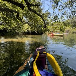
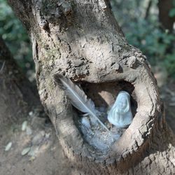
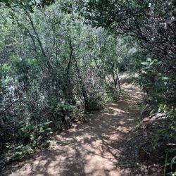
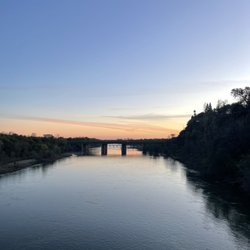
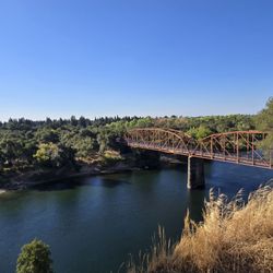
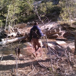
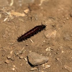
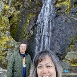
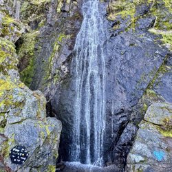
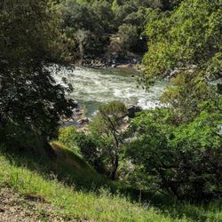
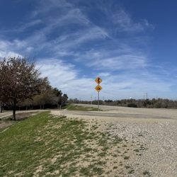
Hinkle Creek Loop Trail can be found in Folsom California. This 1 mile loop trail can be found in the Hinkle Creek Nature Area. The gravel trail winds through Oak wetlands , crossing over Hinkle Creek. It runs a half mile North-East along Oak Ave Parkway, then a half mile back to the Nature Center. Some areas of the trail does have an slight increase in elevation but the majority of the trail is fairly flat. There are 50 markers found all along the trail for a self guided nature awareness tour. It is pretty shaded but still bring a hat and water. This trail is not wheelchair accessible ! Due to muddy conditions during winter months, it is highly recommended to visit during warmer weather. Parking can be found at the Nature Center. Spring is almost here ! Let's hit the trails ! Enjoy ! read more


More info about Hinkle Creek Loop Trail
7000 Baldwin Dam Rd
Folsom, CA 95630
Directions
Hours
Outdoor Amenities


Hinkle Creek Loop Trail - hiking - Updated June 2026
Best of Folsom
People found Hinkle Creek Loop Trail by searching for…
Hiking Trails in Folsom, California
Walking Trails in Folsom, California
Beautiful Views in Folsom, California
River Access in Folsom, California
Running Trails in Folsom, California
Places to Take Pictures in Folsom, California
Nature Center in Folsom, California
Scenic Night View in Folsom, California
Free Things to Do in Folsom, California
Romantic Views in Folsom, California
Night Hike in Folsom, California
Fall Foliage in Folsom, California
Urban Exploration in Folsom, California
Scenic Spots in Folsom, California
Off Leash Dog Hikes in Folsom, California
Off Road Trails in Folsom, California
Trending Searches in Folsom, CA
Black Owned Nail Salons near Hinkle Creek Loop Trail
Boat Rental near Hinkle Creek Loop Trail
Cliff Jumping near Hinkle Creek Loop Trail
Creeks near Hinkle Creek Loop Trail
Day Trips near Hinkle Creek Loop Trail
Dog Friendly Trails near Hinkle Creek Loop Trail
Fireworks near Hinkle Creek Loop Trail
Fishing Spots near Hinkle Creek Loop Trail
Jet Ski Rental near Hinkle Creek Loop Trail
Kayak Rental near Hinkle Creek Loop Trail
Lakes & Ponds near Hinkle Creek Loop Trail
Outdoor Activities near Hinkle Creek Loop Trail
Places To Walk Around near Hinkle Creek Loop Trail
Public Pools near Hinkle Creek Loop Trail
Public Shower near Hinkle Creek Loop Trail
River Swimming near Hinkle Creek Loop Trail
Rock Quarry near Hinkle Creek Loop Trail
Scenic Night View near Hinkle Creek Loop Trail
Scenic Overlook near Hinkle Creek Loop Trail
Secluded Spots near Hinkle Creek Loop Trail
Soccer Store near Hinkle Creek Loop Trail
Splash Pad near Hinkle Creek Loop Trail
Strawberry Picking near Hinkle Creek Loop Trail
Sunrise View near Hinkle Creek Loop Trail
Swimming Holes near Hinkle Creek Loop Trail
Swimming Lakes near Hinkle Creek Loop Trail
Watch Sunset near Hinkle Creek Loop Trail
Browse Articles
Browse Nearby
BEST of Folsom, California Restaurants near Hinkle Creek Loop Trail
BEST of Folsom, California Coffee near Hinkle Creek Loop Trail
BEST of Folsom, California Things to Do near Hinkle Creek Loop Trail
BEST of Folsom, California Walking Trails near Hinkle Creek Loop Trail
BEST of Folsom, California Breakfast near Hinkle Creek Loop Trail
BEST of Folsom, California Parks near Hinkle Creek Loop Trail
BEST of Folsom, California Caves near Hinkle Creek Loop Trail
BEST of Folsom, California Hot Springs near Hinkle Creek Loop Trail
BEST of Folsom, California Campgrounds near Hinkle Creek Loop Trail
Browse Brands
Related Searches in Folsom, CA
Affordable Kayak Rental Services in Folsom, California
Best Fishing Locations and Guides in Folsom, California
Best Nature Trails for Hiking in Folsom, California
Best Places for Horseback Riding in Folsom, California
Check Out Off Road Trails in Folsom, California
Discover Dog Friendly Trails to Explore in Folsom, California
Discover Kid Friendly Hiking Trails in Folsom, California
Discover Scenic Mountain Bike Trails Near Folsom, California
Discover Scenic Waterfall Spots in Folsom, California
Discover Top State Parks to Visit in Folsom, California
Discover Walking Parks in Folsom, California Near You
Discover a Hiking Trail in Folsom, California
Discover the Best Night Hike Trails in Folsom, California
Dog-Friendly Hikes With Dogs in Folsom, California
Enjoy Camping Adventures Around Folsom, California
Enjoy Kayaking Adventures in Folsom, California
Enjoy Tent Camping Spots Around Folsom, California
Enjoy a Beautiful Waterfall Hike in Folsom, California
Enjoy the Best Picnic Spots and Ideas in Folsom, California
Enjoy the Best Walking Path in Folsom, California
Enjoy the Best Walking Trails in Folsom, California
Experience Thrilling White Water Rafting in Folsom, California
Explore Beautiful Parks and Green Spaces in Folsom, California
Explore Easy Hikes Perfect for All in Folsom, California
Explore Fun Activities to Do in Folsom, California
Explore Popular Campgrounds Near Folsom, California
Explore the Best Beach Spots in Folsom, California
Explore the Best Swimming Holes Around Folsom, California
Explore the Best Trail Options in Folsom, California
Family Friendly Hiking With Kids in Folsom, California
Find Beautiful Views in Folsom, California
Find Popular Ziplining Spots Around Folsom, California
Find the Best Parks for Picnics in Folsom, California
Find the Best Scenic View Locations in Folsom, California
Great Places to Walk in Folsom, California
Hike the Popular Waterfall Trail in Folsom, California
Hiking Trails With Waterfalls in Folsom, California
Off Leash Dog Hiking Trails in Folsom, California
Plan a Scenic Drive Route Near Folsom, California
Popular Outdoor Activities to Try in Folsom, California
Popular Picnic Spots to Visit in Folsom, California
Safe River Swimming Areas in Folsom, California
Safe and Fun Parks for Kids in Folsom, California
Top Climbing Spots and Gyms in Folsom, California
Top Paddleboarding Activities in Folsom, California
Top Running Trails to Explore in Folsom, California
Top Swimming Lakes to Enjoy in Folsom, California
Top Swimming Spots and Pools in Folsom, California
People who viewed Hinkle Creek Loop Trail also viewed
Lake Natoma Trail
9 reviews
South Fork American River Trail
6 reviews
Anatolia Wetland Preserve Trail
3 reviews
American River Parkway - Hazel Access
3 reviews
Dave Moore Nature Area
16 reviews
Folsom Parkway Rail Trail
2 reviews
Squaw Valley Hiking
2 reviews
Amos P. Catlin Park
7 reviews
El Dorado Trail
2 reviews
Humbug Willow Creek Trail
4 reviews