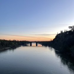
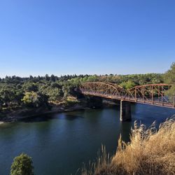
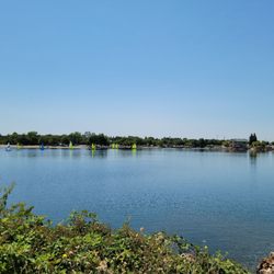
Squaw Valley Hiking Photos


You might also consider
More like Squaw Valley Hiking
Recommended Reviews - Squaw Valley Hiking
Start your review...

1 month ago


5 years ago
17 years ago
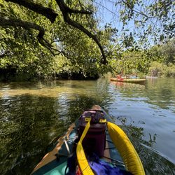
One of the best hikes in the country !!! about a two hours hike straight up with some mini rock climbing.... At the end you will find a nice mini lake...ok ok a pond....its very nice! I took a (cold) swim right before heading back and was dry by the time we got back. youcan opt to take the gondola back to town or hike back down ----be careful !!! we just saw a lady brake her ankle on her way down.... we were really careful after that.... read more
More info about Squaw Valley Hiking
Granite Bay, CA 95746
Directions
Hours
Outdoor Amenities
You might also consider


Squaw Valley Hiking - hiking - Updated May 2026
Best of Granite Bay
People found Squaw Valley Hiking by searching for…
Things to Do in Granite Bay, CA
Rock Climbing in Granite Bay, CA
Hiking Trails in Granite Bay, CA
Swimming Lakes in Granite Bay, CA
Lakes & Ponds in Granite Bay, CA
Walking Trails in Granite Bay, CA
Hiking With Kids in Granite Bay, CA
Fall Foliage in Granite Bay, CA
Things to Do at Night in Granite Bay, CA
Scenic View in Granite Bay, CA
Off Leash Dog Hikes in Granite Bay, CA
Running Trails in Granite Bay, CA
Fun Things to Do With Kids in Granite Bay, CA
Places to Walk at Night in Granite Bay, CA
Walking Groups in Granite Bay, CA
Watch Sunset in Granite Bay, CA
Places to Walk in Granite Bay, CA
Trending Searches in Granite Bay, CA
Botanical Gardens near Squaw Valley Hiking
Bounce House Rentals near Squaw Valley Hiking
Campgrounds near Squaw Valley Hiking
Cheap Plants near Squaw Valley Hiking
Cherry Picking near Squaw Valley Hiking
Cliff Jumping near Squaw Valley Hiking
Dog Friendly Things To Do near Squaw Valley Hiking
Flower Fields near Squaw Valley Hiking
Flower Shop near Squaw Valley Hiking
Garage Sales near Squaw Valley Hiking
Garden Center near Squaw Valley Hiking
Lakes & Ponds near Squaw Valley Hiking
Nurseries & Gardening near Squaw Valley Hiking
Outdoor Activities near Squaw Valley Hiking
Outdoor Furniture Stores near Squaw Valley Hiking
Parks near Squaw Valley Hiking
Party Equipment Rentals near Squaw Valley Hiking
Pedicure near Squaw Valley Hiking
Photo Spots near Squaw Valley Hiking
Picnic Areas near Squaw Valley Hiking
Places To Take Pictures near Squaw Valley Hiking
Rock Quarry near Squaw Valley Hiking
Running Trails near Squaw Valley Hiking
Rv Rental near Squaw Valley Hiking
Spray Tanning near Squaw Valley Hiking
Sunrise View near Squaw Valley Hiking
Swimming Holes near Squaw Valley Hiking
Table And Chair Rentals near Squaw Valley Hiking
Browse Articles
Browse Nearby
BEST of Granite Bay, California Coffee near Squaw Valley Hiking
BEST of Granite Bay, California Restaurants near Squaw Valley Hiking
BEST of Granite Bay, California Things to Do near Squaw Valley Hiking
BEST of Granite Bay, California Walking Trails near Squaw Valley Hiking
BEST of Granite Bay, California Breakfast near Squaw Valley Hiking
BEST of Granite Bay, California Parks near Squaw Valley Hiking
BEST of Granite Bay, California Campgrounds near Squaw Valley Hiking
BEST of Granite Bay, California Hotels near Squaw Valley Hiking
BEST of Granite Bay, California Sledding near Squaw Valley Hiking
Browse Brands
Related Searches in Granite Bay, CA
Affordable Kayak Rental Services in Granite Bay, California
Best Fishing Locations and Guides in Granite Bay, California
Best Nature Trails for Hiking in Granite Bay, California
Best Places for Horseback Riding in Granite Bay, California
Best Waterfalls and Swimming Holes in Granite Bay, California
Check Out Off Road Trails in Granite Bay, California
Discover Dog Friendly Trails to Explore in Granite Bay, California
Discover Kid Friendly Hiking Trails in Granite Bay, California
Discover Scenic Mountain Bike Trails Near Granite Bay, California
Discover Scenic Waterfall Spots in Granite Bay, California
Discover Top State Parks to Visit in Granite Bay, California
Discover Walking Parks in Granite Bay, California Near You
Discover a Hiking Trail in Granite Bay, California
Discover the Best Night Hike Trails in Granite Bay, California
Dog-Friendly Hikes With Dogs in Granite Bay, California
Enjoy Camping Adventures Around Granite Bay, California
Enjoy Kayaking Adventures in Granite Bay, California
Enjoy Tent Camping Spots Around Granite Bay, California
Enjoy a Beautiful Waterfall Hike in Granite Bay, California
Enjoy the Best Picnic Spots and Ideas in Granite Bay, California
Enjoy the Best Walking Path in Granite Bay, California
Enjoy the Best Walking Trails in Granite Bay, California
Experience Thrilling White Water Rafting in Granite Bay, California
Explore Beautiful Parks and Green Spaces in Granite Bay, California
Explore Easy Hikes Perfect for All in Granite Bay, California
Explore Fun Activities to Do in Granite Bay, California
Explore Popular Campgrounds Near Granite Bay, California
Explore the Best Beach Spots in Granite Bay, California
Explore the Best Swimming Holes Around Granite Bay, California
Explore the Best Trail Options in Granite Bay, California
Family Friendly Hiking With Kids in Granite Bay, California
Find Popular Ziplining Spots Around Granite Bay, California
Find the Best Parks for Picnics in Granite Bay, California
Great Places to Walk in Granite Bay, California
Hike the Popular Waterfall Trail in Granite Bay, California
Hiking Trails With Waterfalls in Granite Bay, California
Off Leash Dog Hiking Trails in Granite Bay, California
Plan a Scenic Drive Route Near Granite Bay, California
Popular Outdoor Activities to Try in Granite Bay, California
Popular Picnic Spots to Visit in Granite Bay, California
Safe River Swimming Areas in Granite Bay, California
Safe and Fun Parks for Kids in Granite Bay, California
Top Climbing Spots and Gyms in Granite Bay, California
Top Paddleboarding Activities in Granite Bay, California
Top Running Trails to Explore in Granite Bay, California
Top Swimming Lakes to Enjoy in Granite Bay, California
Top Swimming Spots and Pools in Granite Bay, California
Top Things to Do With Kids in Granite Bay, California
Walk Dog Friendly Hiking Trails in Granite Bay, California
Walk the Best Paved Walking Trails in Granite Bay, California
People who viewed Squaw Valley Hiking also viewed
Cronan Ranch Trails Park
32 reviews
American River Parkway - Sailor Bar
13 reviews
Lake Natoma Waterfront Access Trail
9 reviews
American River Confluence
11 reviews
Lake Natoma Trail
8 reviews
Hinkle Creek Loop Trail
3 reviews
Hinkle Creek Nature Area
11 reviews
American River Parkway - Hazel Access
3 reviews
Olmstead Loop Trail
4 reviews
South Fork American River Trail
6 reviews